Yingkiong is a town and the administrative headquarter of Upper Siang district in the Northeast Indian state of Arunachal Pradesh.[1] It is a small town located 250 kilometres (160 mi) north of Itanagar, the capital of the state[2] and 1 kilometre (0.62 mi) east of the River Siang.[3] According to the 2011 Census, the town has a total population of 8,573 persons.[4]
The district of Upper Siang (where Yingkiong is located) was a division of the East Siang district until 1995, then it split from East Siang district as a separate administrative district North-west of Pasighat.[5] The administrative district Upper Siang is as old as the period when Arunachal Pradesh was a region independent of British occupation.[6] The region was not brought under administrative control of the British or other powers until the Anglo-Burmese war of 1826-1861.Post the Anglo-Burmese war followed by signing of Treaty of Yandaboo between Burma and the British expeditionary forces, Burma ceded the North-Eastern region of Assam,[7]Cachar, and Manipur,[8] to the British.[9] However, the British control had not extended to the state of Arunachal Pradesh as a whole, as the British only annexed land up to Pasighat in the East Siang, Arunachal Pradesh. In 1911, post the Anglo-Abor wars, the British gained administrative control of Upper Siang and as a result the district fell under the administrative control of the Assistant Political Officer stationed at Sadiya in Assam during the period. Some prominent Assistant Political Officer are Francis Jack Needham who was appointed in 1882,[10] and Noel Williamson who was assassinated by locals of Komsing village in East Siang district.[11][12]
The topography of Yingkiong is characterised by hilly terrains and river valleys.[13] The town sits at an elevation of 200 m (660 ft) above sea level. Yingkiong is surrounded by hills, and the Siang River flows on its west. Tuting, Singging, and Bishing towns lie north of Yingkiong, geographically close to Indo-China border. Simong, Gobuk, Puging, Pangkang, Gette, Moying, Bomdo, Likor, and Millang, are some of the villages and hamlets that surround Yingkiong.
Climate
Yingkiong has a relatively warm and humid subtropical climate. The highest recorded temperature in Yingkiong is 39 °C during summer, and 4 °C in winter.[14] The highest recorded annual rainfall of Yingkiong is 3116 mm.[15] The upper parts of the city receives snowfall for most of the year.
Villagers trekking to upper region of Yingkiong town covered with snow for a major period of the year.
Economy
The majority of Yingkiong households practices farming for basic livelihood,along with it fruits and vegetable cultivation are common for commercial purpose which is endorsed by local administration through MIDH (Mission For Integrated Development of Horticulture) a centrally sponsored scheme of Ministry of Agriculture and Farmers Welfare,Government of India.[16][17] Of the gross 69 percent of households engaged in agriculture in Upper Siang, Yingkiong township has the highest number of urban agrarian households.[14]Jhum cultivation (slash and burn) and terrace farming are the most common farming techniques. Rice, maize and millet are the main food crops. Cash crops like turmeric and sugarcane are commonly grown.[18] Along with agricultural products, handicrafts such as woven bamboo stools known as "Murha" are commonplace at the market. Cultivation of seasonal fruits like oranges and pineapple are common, and during periods of favourable cultivation and surplus output, they are bulk transported for sale in local markets or outside the town in Pasighat. Pisciculture (Fish farming) is also common and it is promoted under centrally sponsored FFDA (Fish Farmer Development Agency) programme to generate employment for locals and revenue for the State.[19] The Adi tribe are remarked as skillful in making a distinct type of traditional basket called 'Egin'. It is used frequently by the locals for carrying household items like rice,dried woods and host of other edibles and farm produces.[20] A variety of Black and Red Tea called Siang Tea[21] are also produced at Deki Tea estate at Ramsing Village for export and domestic consumption.[22]
Demographics
According to 2011 census of the Government of India, the town has a total population of 8,573 people. The male population was 4,381 and the female population 4,192, with 1,139 persons in the age group of 0 to 6. The total working population was 3,787 persons, with the male working population at 2,221 and the female working population at 1,566.[23] The literacy rate of the region is 64%. The female literacy rate is 44.89% and the male literacy rate is 55%.[24] It has a non-working population of 4,786 persons, mostly of dependent age. Adi is the major dialect spoken in the area. The Hindi language is commonly used as a Lingua franca to communicate with people of diverse speech or with people who do not speak Adi.
Religion
The following table shows the population by religion, according to the 2001 census.
Total Population
Hinduism
Islam
Christianity
Sikhism
Buddhist
Jain
Donyi-Polo
Not Stated
Total Population
6,540
2,028
198
1,061
4
117
0
3,075
57
Culture
Festivals
The locals of Yingkiong celebrate the Solung,[25] Aran (Unying-Aran), Etor,[26] Siang River Darshan and Mopin festivals.
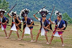
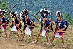
Tapu ( a typical aggressive posturing by male members of Adi tribe ) during Aran festival staging the war cry dance during actual tribe wars done as a 'warm up' before the real armed conflict.Solung festival is celebrated for agriculture and good harvest, prevalent among the Adi community are various myths, stories, faiths and beliefs about the origin of the Solung festivity. Generally celebrated mid August–September, the date for the festival is fixed by the village council called 'Kebang'.[14] Sometimes, the 'Gam' (village headman) fixes the date in consultation with other leaders of the village. On the day, villagers prepare rice-beer ('Apong'). Fresh vegetables and plenty of meats are also stored for the occasion.
Aran (Unying Aran) is a new year festival of the Adi community celebrated in the districts of East and Upper Siang.[27] It marks the arrival of the spring season. During the festival, male elders of the village perform the Bari dance, and young boys and girls performs the Yakjong dance. The dances narrate the stories of the origin of the festival, and they also pray for good health and prosperity of the people.
Etor festival is celebrated on May 15 by Adi tribes of East and Upper Siang. Etor literally means 'fence' since it is related to protection of crops by fencing cultivated lands and earlier local bovine (Mithuns) were kept protected using fencing in large fields.[28] Huge feast and offerings are made to gods and is celebrated to begin the annual agricultural cycle of the community[26]
Tribal women performing traditional welcome dance (Ponung) as a part of Siang River festival.Siang River festival, previously known as the Brahmaputra Darshan Festival, was later rechristened Siang River Festival. After 2005, Yingkiong, Tuting, and Pasighat were chosen as the places to conduct this festival of Communal Harmony.[29]
Transport
The town is connected to the rest of the country and Arunachal Pradesh via National Highway 513 (NH-513) and NH-52 from Pasighat (126 km) to Itanagar (392 km). Modes of transport include sumo (taxi) services and APSTs (Arunachal Pradesh State Transport) bus services.[30] Gelling-Tuting-Yingkiong-Pasighat strategic India-China Border Roads connects it Line of Actual Control (LAC) in the north at Gelling circle HQ which is also an ITBP station.
In January 2019, Gandhi Bridge - a 300 meter long cable stayed suspension foot-bridge, was constructed over the Brahmaputra River to connect the Tuting town on the eastern bank to the road to Tuting-Gelling on the western bank, thus reducing 40 km travel distance for 20,000 residents of nearby villages.[31]
Earlier aerial connectivity was limited to Mohanbari Airport in Dibrugarh.[30][32] In 2018, a newly built Pasighat Airport was operationalised in Pasighat town,[33] which is currently the nearest airport to reach Yingkiong. There is direct aerial connectivity to Yingkiong through the helicopter services which are available from Pasighat, Itanagar and from Assam.[34] There are two heliports in the town, one near Siang and the other opposite of the District Collector office in Yingkiong that facilitates helicopter landing services.[35]
The nearest railway station is 165 km south at Murkongselek in the Jonai District of Assam.[36] to connect Yingkiong town via Pasighat.[37]
Tourism
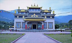
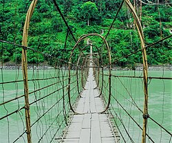
Palyul Monastery in Upper SiangGandhi Bridge( a makeshift swinging bridge) over the Siang river, made of cane and bamboo.it is a major tourist attraction across Siang river
Notable tourist spots in and around the town:
Jengging-Yingkiong Circuit — a small town and trekking site, situated at a distance of approximately 20 km (12 mi).
Palyul Gompa — a sacred Buddhist temple, located in Tuting,[39] roughly 300 km (190 mi) from Yingkiong towards the North.[40]
Tuting-Geling Singha Triangle — the 'Pemako Zone' of the Tibetan form of Buddhism;[41] it lies amidst natural lakes,close to the Indo-China border.
Gandhi Bridge — a hanging bridge over river Siang,[42] made of cane[43] and timber, on the way to Tuting and Moying.
Ekodumbeng-Ruitala — a region famous for tuber-root like poisonous aconite used for hunting game; animals sighted here include the Gnu goat, musk deer, and various bird species.[44] This place also hold religious significance for followers of Buddhism as these region is also called Riu Tala-(Amlokeshwara) meaning a Paradise.[45][46]
Pekimodi Village near Mariyang town largely untouched by modern development projects.Mariyang-Pekimodi — home to native tribes of Upper Siang called Pasi, Padam, Dalbing, Millang at a distance of 50 km (31 mi) southeast of Yingkiong is the small town of Mariyang, situated at the confluence of the Yammeng and Yamne rivers. Damroh village (located here) is the largest village in the Upper Siang district.[44] This region is known for sightings of aircraft wreckage of United States lost in 1944 during the Second World War.[47][48]
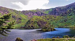
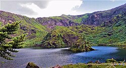
View of sacred Tsitapuri Lake in Upper SiangTsitapuri Circuit — pilgrimage site amidst serene lakes and mountains, covered with snows throughout the year.[49] It is considered as one of the dwelling abode of Holy Guru Rinpoche .It has around 108 lakes.Lake Dhankosa is the most well known among them.[50] Followers of Buddhism hold popular belief that here anyone with pure heart witness different sacred wild animals.[51]
Nay Dewakota- The word Dewakota translate to 'Abode of God' Nay means the 'Sacred Site' this place is nestled in a plateau flanked by Nyigong river approximately 40 kilometres ahead of Tuting Village in Upper Siang and owing to rough terrain this region is not accessible by motor vehicles.[51] It is believed by devotees of Buddhism that in this sacred pilgrimage site Holy Guru Rinpoche has treasured holy scripts and sacred items yet to be discovered and deciphered,the place also houses numerous caves considered holy by Buddhist locals.[52]
Covid-19
The town has so far reported multiple confirmed cases of covid-19 infections. Among them were a student returnee from National Capital Region and the Health and Family Welfare Minister of Arunachal Pradesh who is a native of Yingkiong.The town has no covid-19 testing lab facility so far .[53][54]
Notable people
Gegong Apang — served as Chief Minister of Arunachal Pradesh for 22 years, making him the longest serving Chief Minister of Arunachal Pradesh.[55] He is also the third-longest serving Chief Minister in India after Pawan Kumar Chamling of Sikkim[56] and Jyoti Basu of West Bengal as of 2021.[57][58]
Alo Libang — Minister, Health & Family Welfare, Social Welfare, Women & Child Development, Social Justice, Empowerment & Tribal Affairs.[59]
↑Managing natural resources : focus on land and water : felicitation volume in honour of Professor R.L. Dwivedi. Dwivedi, R. L., 1924-, Misra, H. N. (Harikesh N.), 1945-. Delhi. 13 March 2014. ISBN9788120349339. OCLC893309586.{{cite book}}: CS1 maint: location missing publisher (link) CS1 maint: others (link)
↑ 26.026.1Mishra, B.P.; Kumawat, M.M.; Kumar, Naresh; Riba, Toge; Kumar, Sanjeev (2016). "Significance of Aran Festival for Rodent Management by Adi Tribes of Arunachal Pradesh". Journal of Global Communication. 9 (1): 15. doi:10.5958/0976-2442.2016.00004.5. ISSN0974-0600.
↑Pathak, Guptajit; Gogoi, Raju (2008). Cultural fiesta in the "Island of peace" Arunachal Pradesh. New Delhi, India: Mittal Publications. ISBN978-8183242318. OCLC277280040.






 India
India