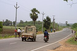
Nellipaka
Nellipaka | |
|---|---|
 National Highway 221(NH 221) near Nellipaka | |
| Coordinates: 17°40′0″N 80°59′0″E / 17.66667°N 80.98333°ECoordinates: 17°40′0″N 80°59′0″E / 17.66667°N 80.98333°E | |
| Country | |
| State | Andhra Pradesh |
| District | Alluri Sitharama Raju district |
| Language | |
| • Official | Telugu |
| Time zone | UTC+5:30 (IST) |
| PIN | 507129 |
| Vehicle registration | AP |
Nellipaka is a village in the [[Nellipaka mandal] in the Alluri Sitharama Raju district of the Indian state of Andhra Pradesh. It is located in Rampachodavaram revenue division.[1]
History[edit]
In 2022, as a part of the raising the number of districts in Andhra Pradesh from 13 to 26, Visakhapatnam district was split into three districts – Alluri Sitharama Raju district, Anakapalli district and Visakhapatnam district.[2]
Geography[edit]
It is located at 17°40′0″N 80°59′0″E / 17.66667°N 80.98333°E.
Transport[edit]
Nellipaka is connected to Vijayawada by National Highway 30 (India).
See also[edit]
References[edit]
- ↑ "Alluri Sitharama Raju District". About District > Administrative Setup > Mandals. Government of Andhra Pradesh. Retrieved 28 January 2024.
- ↑ "Visakhapatnam divided into 3 new districts by the AP State Government". Yo!Vizag. Retrieved 27 January 2024.


