






Ajay Kumar (talk | contribs) Created a new article |
brief updated section after review |
||
| Line 1: | Line 1: | ||
{{Short description|Division of Bangladesh}} | {{Short description|Division of Bangladesh}} | ||
{{About|Rangpur as a division in Bangladesh|other uses|Rangpur (disambiguation)}} | {{About|Rangpur as a division in Bangladesh|other uses|Rangpur (disambiguation)}} | ||
{{Infobox settlement | {{Infobox settlement | ||
| name = Rangpur Division | |||
| native_name | | native_name = রংপুর বিভাগ | ||
| native_name_lang | | native_name_lang = bn | ||
| settlement_type | | settlement_type = [[Divisions of Bangladesh|Division of Bangladesh]] | ||
| | | other_name = | ||
| | | nickname = [[North Bengal]] | ||
| image_seal | | image_skyline = {{Multiple image | ||
| image_map | | border = infobox | ||
| | | total_width = 300 | ||
| | | caption_align = center | ||
| | | perrow = 1/2/2/2/1 | ||
| | | image1 = Teesta Barrage Bangladesh.jpg | ||
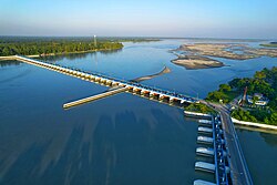
| coordinates | | caption1 = [[:bn:তিস্তা সেচ প্রকল্প|Teesta Barrage]] in [[Lalmonirhat District|Lalmonirhat]] | ||
| coor_pinpoint | | image2 = Tajhat Palace Rangpur city.jpg | ||
| coordinates_footnotes | | caption2 = [[Tajhat Palace]] in [[Rangpur District|Rangpur]] | ||
| subdivision_type | | image3 = Saidpurairport-renovated.jpg | ||
| subdivision_name | | caption3 = [[Saidpur Airport]] in [[Nilphamari District|Nilphamari]] | ||
| established_title | | image4 = Dome of Balia Mosque.jpg | ||
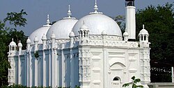
| established_date | | caption4 = [[Balia Mosque]] in [[Thakurgaon District|Thakurgaon]] | ||
| seat_type | | image5 = Kanchenjunga view from Bangladesh.jpg | ||
| seat | | caption5 = [[Tetulia Tea Garden|Tea Garden]] in [[Panchagarh District|Panchagarh]] | ||
| government_footnotes | | image6 = Fulsori Ghat Gaibandha.jpg | ||
| leader_party | | caption6 = [[:bn:বালাসী ঘাট|Balasi Ghat]] in [[Gaibandha District|Gaibandha]] | ||
| | | image7 = হাজির হাট, কুড়িগ্রাম.jpg | ||
| | | caption7 = [[Jamuna River]] in [[Kurigram District|Kurigram]] | ||
| | | image8 = Nawabganj National Park Dinajpur 3254.jpg | ||
| | | caption8 = [[Nawabganj National Park]] in [[Dinajpur District, Bangladesh|Dinajpur]] | ||
| unit_pref | }} | ||
| area_footnotes | | image_seal = | ||
| area_total_km2 | | image_map = {{switcher|[[File:Rangpur in Bangladesh.svg|upright=1.15|frameless]]|Rangpur Division in Bangladesh|[[File:Rangpur Division districts map.png|upright=1.15|frameless]]|Districts of Rangpur Division|[[file:Rangpur division relief map.svg|upright=1.15|frameless]]|Relief map of Rangpur Division}} | ||
| area_note | | map_alt = | ||
| elevation_footnotes | | map_caption = | ||
| elevation_m | | image_map1 = | ||
| | | map_caption1 = | ||
| | | coordinates = {{coord|25|50|N|89|00|E|region:BD_type:adm1st_source:GNS-enwiki|display=inline,title}} | ||
| | | coor_pinpoint = | ||
| | | coordinates_footnotes = | ||
| population_density_km2 | | subdivision_type = Country | ||
| population_note | | subdivision_name = {{flag|Bangladesh}} | ||
| blank_name_sec1 | | subdivision_type1 = | ||
| blank_info_sec1 | | subdivision_name1 = | ||
| timezone1 | | subdivision_type2 = | ||
| utc_offset1 | | subdivision_name2 = | ||
| iso_code | | subdivision_type3 = | ||
| website | | subdivision_name3 = | ||
| | | established_title = Established | ||
| blank_name_sec2 | | established_date = 1 July 2010 | ||
| blank_info_sec2 | | seat_type = Capital<br />{{nowrap|{{nobold|and largest city}}}} | ||
| seat = [[Rangpur City]] | |||
| government_footnotes = | |||
| leader_party = | |||
| leader_title1 = [[Divisional Commissioner of Bangladesh|Divisional Commissioner]] | |||
| leader_name1 = [https://www.rangpurdiv.gov.bd/en/site/view/officer_list Md. Shahidul Islam]<ref>{{cite web |url=https://www.rangpurdiv.gov.bd/bn/site/page/MZwp--বিভাগীয়-কমিশনার-রংপুর |title=Divisional Commissioner of Rangpur}}</ref> | |||
| leader_title2 = [[Deputy Inspector General of Police|Deputy Inspector General]] | |||
| leader_name2 = [https://rangpurrange.police.gov.bd/কর্মকর্তাবৃন্দ/ Aminul Islam] | |||
| leader_title3 = [[Parliament of Bangladesh|Parliamentary constituency]] | |||
| leader_name3 = [[Jatiya Sangsad]] ([[List of parliamentary constituencies of Bangladesh#Rangpur Division|33 seats]]) | |||
| unit_pref = Metric | |||
| area_footnotes = | |||
| area_total_km2 = 16184.99 | |||
| area_land_km2 = | |||
| area_water_km2 = | |||
| area_note = | |||
| area_rank = 5th | |||
| dimensions_footnotes = | |||
| length_km = 216 | |||
| length_mi = 134 | |||
| width_km = 85 | |||
| width_mi = 52 | |||
| elevation_footnotes = <ref>{{cite web |url=https://en-gb.topographic-map.com/map-wq1m2/Rangpur-Division/ |title=Rangpur Division topographic map, elevation, terrain}}</ref> | |||
| elevation_m = 42 | |||
| elevation_ft = 137.8 | |||
| elevation_point = | |||
| elevation_max_footnotes = <ref>{{cite web |url=https://en-gb.topographic-map.com/map-zmh23q/Tetulia/ |title=Tetulia topographic map, elevation, terrain}}</ref> | |||
| elevation_max_m = 134 | |||
| elevation_max_ft = 439.6 | |||
| elevation_max_point = | |||
| elevation_min_footnotes = <ref>{{cite web |url=https://en-gb.topographic-map.com/map-rlr3cz/Gaibandha/ |title=Gaibandha topographic map, elevation, terrain}}</ref> | |||
| elevation_min_m = 10 | |||
| elevation_min_ft = 32.8 | |||
| elevation_min_point = | |||
| population_total = 17610956 | |||
| population_as_of = [[2022 Bangladeshi census|2022]] | |||
| population_footnotes = | |||
| population_density_km2 = auto | |||
| population_note = | |||
| population_rank = 4th | |||
| population_demonym = [[Bangladeshis|Rangpuriya]] | |||
| blank_name_sec1 = [[Human Development Index|HDI]] (2022) | |||
| blank_info_sec1 = {{Increase}} 0.656 {{color|#fc0|medium}}<ref>{{Cite web |title=Subnational HDI (v8.0) |url=https://globaldatalab.org/shdi/table/shdi/BGD/?levels=1+4&years=2022&extrapolation=0}}</ref> | |||
| timezone1 = [[Bangladesh Standard Time|BST]] | |||
| utc_offset1 = +6:00 | |||
| postal_code_type = [[Postal codes in Bangladesh|Postal Code]] | |||
| postal_code = 5XXX | |||
| iso_code = BD-F | |||
| website = {{URL|rangpurdiv.gov.bd}} | |||
| demographics_type1 = Languages | |||
| demographics1_title1 = [[Official language]] | |||
| demographics1_info1 = [[Bengali language|Bengali]]{{*}}English<ref name="bdlaws.minlaw.gov.bd">{{cite web |url=http://bdlaws.minlaw.gov.bd/act-details-367.html |title=The Constitution of the People's Republic of Bangladesh |website=[[Ministry of Law, Justice and Parliamentary Affairs]] |access-date=1 February 2017 |archive-date=10 November 2019 |archive-url=https://web.archive.org/web/20191110101626/http://bdlaws.minlaw.gov.bd/act-details-367.html |url-status=live}}</ref> | |||
| demographics1_title2 = [[Regional language]] | |||
| demographics1_info2 = [[Rangpuri language|Rangpuri]] | |||
| demographics1_title3 = {{nobold|[[Indigenous language|Indigenous]] [[minority language]]s}} | |||
| demographics1_info3 = {{Collapsible list | |||
| titlestyle = background:transparent;text-align:left;font-weight:normal;font-size:100%; | |||
| title = List | |||
|[[Santali language|Santali]] | |||
|[[Mundari language|Mundari]] | |||
|[[Kurukh language|Kurukh]] | |||
|[[Odia language|Odia]] | |||
|[[Koch language|Koch]] | |||
|[[Assamese language|Assamese]]}} | |||
| blank_name_sec2 = Notable cricket teams | |||
| blank_info_sec2 = [[Rangpur Riders]] | |||
[[Rangpur Division cricket team|Rangpur Division]] | |||
| blank1_name = [[List of roads in Bangladesh|National Highway]] | |||
| blank1_info = [[N5 (Bangladesh)|N5]] [[File:NH-5 BGD.svg|26px]]<br />[[Asian Highway 2]] [[File:Tabliczka AH2.svg|26px]] | |||
| blank2_name = Airport | |||
| blank2_info = [[Saidpur Airport]] | |||
}} | }} | ||
'''Rangpur Division''' ({{IPAc-en|r|ʌ|ŋ|ˈ|p|ʊər}}; {{langx|bn|রংপুর বিভাগ|Rongpur Bivag}}; | |||
{{IPA|bn|rɔŋpuɾ bibʱag|pron|Rangpur pronunciation.ogg}}) is a first-level [[Divisions of Bangladesh|administrative division of Bangladesh]]. It covers the northernmost part of the country with a population of about 18 million inhabitants within an area of {{convert| 16184.99|km2|sqmi|abbr=on}}.<ref name=Banglapedia>{{Cite Banglapedia |article=Rangpur Division}}</ref> Rangpur Division shares borders with the [[Rajshahi Division|Rajshahi]] and [[Mymensingh Division|Mymensingh]] divisions. It is also bordered by the [[Indian state]]s of [[West Bengal]], [[Assam]] and [[Meghalaya]] and separated from [[Bhutan]] and [[Nepal]] by the [[Siliguri Corridor]], and from China by the Indian state of [[Sikkim]]. [[Rangpur, Bangladesh|Rangpur City]] is the administrative headquarter and the largest city. Rangpur Division includes the [[Teesta River|Teesta]] and [[Jamuna River|Jamuna]] rivers.<ref>{{cite web |url=https://www.rangpurdiv.gov.bd/en/site/page/Ynid-বিভাগের-ঐতিহ্য |title=Tradition of the Division |website=Rangpur Division}}</ref> | |||
[[Man Singh I|Mansingh]], commander of [[Emperor Akbar]], conquered part of Rangpur in 1575. Rangpur came completely under the [[Mughal Empire|Mughal empire]] in 1686. Mughalbasa and Mughalhat of Kurigram district still bear marks of the [[Mughal Empire|Mughal]] rule in the region. During the Mughal rule part of Rangpur was under the [[Sarkar ( | The Rangpur division consists of eight districts. There are 58 upazilas or subdistricts under these eight districts. The major cities of Rangpur Division are [[Rangpur, Bangladesh|Rangpur]], [[Dinajpur]], and [[Saidpur, Bangladesh|Saidpur]]. | ||
== History == | |||
[[Man Singh I|Mansingh]], commander of [[Emperor Akbar]], conquered part of Rangpur in 1575. Rangpur came completely under the [[Mughal Empire|Mughal empire]] in 1686. Mughalbasa and Mughalhat of Kurigram district still bear marks of the [[Mughal Empire|Mughal]] rule in the region. During the [[Mughal Empire|Mughal]] rule part of Rangpur was under the [[Sarkar (administrative division)|sarkar]] of [[Ghoraghat Upazila|Ghoraghat]], and part under the sarkar of Pinjarah.<ref>{{Cite Banglapedia |article=Sarkar}}</ref> [[Ghoraghat Upazila|Ghoraghat]] has been mentioned in the historic book of [[Riyaz-us-Salatin]]. During the early period of the east-india company rule [[Fakir-Sannyasi Rebellion]] and peasant rebellion took place in Rangpur. | |||
== Administrative divisions == | == Administrative divisions == | ||
Rangpur Division | [[File:Rangpur Division districts map.png|thumb|Districts]] | ||
Rangpur Division has 8 Districts, 58 [[Upazila]]s, 1 [[City Corporations in Bangladesh|City Corporation]], 21 [[Pourasava]]s and 536 [[Union councils of Bangladesh|Union councils]]. | |||
{| class="wikitable sortable" style="text-align:center;" | {| class="wikitable sortable" style="text-align:center;" | ||
| Line 71: | Line 142: | ||
!Area (km<sup>2</sup>) | !Area (km<sup>2</sup>) | ||
!Population (2022) | !Population (2022) | ||
|- | |||
![[Rangpur District]] | |||
|[[Rangpur, Bangladesh|Rangpur]] | |||
|2,400.56 | |||
|3,169,615 | |||
|- | |- | ||
![[Dinajpur District, Bangladesh|Dinajpur District]] | ![[Dinajpur District, Bangladesh|Dinajpur District]] | ||
|Dinajpur | |[[Dinajpur]] | ||
|3,444.30 | |3,444.30 | ||
|3,315,238 | |3,315,238 | ||
|- | |- | ||
![[Kurigram District]] | ![[Kurigram District]] | ||
|Kurigram | |[[Kurigram]] | ||
|2,245.04 | |2,245.04 | ||
|2,329,161 | |2,329,161 | ||
|- | |- | ||
![[Gaibandha District]] | ![[Gaibandha District]] | ||
|Gaibandha | |[[Gaibandha]] | ||
|2,179.27 | |2,179.27 | ||
|2,562,232 | |2,562,232 | ||
|- | |- | ||
![[Lalmonirhat District]] | ![[Lalmonirhat District]] | ||
|Lalmonirhat | |[[Lalmonirhat]] | ||
|1,247.371 | |1,247.371 | ||
|1,428,406 | |1,428,406 | ||
|- | |- | ||
![[Nilphamari District]] | ![[Nilphamari District]] | ||
|Nilphamari | |[[Nilphamari]] | ||
|1,643.70 | |1,643.70 | ||
|2,092,567 | |2,092,567 | ||
|- | |- | ||
![[Panchagarh District]] | ![[Panchagarh District]] | ||
|Panchagarh | |[[Panchagarh]] | ||
|1,404.63 | |1,404.63 | ||
|1,179,843 | |1,179,843 | ||
|- | |- | ||
![[Thakurgaon District]] | ![[Thakurgaon District]] | ||
|Thakurgaon | |[[Thakurgaon, Bangladesh|Thakurgaon]] | ||
|1,781.74 | |1,781.74 | ||
|1,533,894 | |1,533,894 | ||
|- | |- | ||
!Total | !Total Districts | ||
|8 | |8 | ||
|16,184.99 | |16,184.99 | ||
| | |17,610,956 | ||
|} | |} | ||
==Demographics== | ==Demographics== | ||
{{bar box | {{bar box | ||
|title=Religions in Rangpur division (2022)<ref>{{ | |title=Religions in Rangpur division (2022)<ref>{{cite web |title=Population and Housing Census 2022: Preliminary Report |url=https://sid.portal.gov.bd/sites/default/files/files/sid.portal.gov.bd/publications/01ad1ffe_cfef_4811_af97_594b6c64d7c3/PHC_Preliminary_Report_(English)_August_2022.pdf |publisher=[[Bangladesh Bureau of Statistics]] |page=16 |date=August 2022 |access-date=25 September 2024}}</ref> | ||
|titlebar=#Fcd116 | |titlebar=#Fcd116 | ||
|left1=Religion | |left1=Religion | ||
| Line 126: | Line 197: | ||
|float=left | |float=left | ||
|bars= | |bars= | ||
{{bar percent|[[Islam in Bangladesh|Muslims]]|green|86. | {{bar percent|[[Islam in Bangladesh|Muslims]]|green|86.51}} | ||
{{bar percent|[[Hinduism in Bangladesh|Hindus]]|darkorange|12.98}} | |||
{{bar percent|Other or not stated|black|0. | {{bar percent|[[Hinduism in Bangladesh|Hindus]]|darkorange|12.98}}{{bar percent|[[Christianity in Bangladesh|Christians]]|darkblue|0.41}} | ||
{{bar percent|[[Buddhism in Bangladesh|Buddhism]]|yellow|0.02}} | |||
{{bar percent|Other or not stated|black|0.08}} | |||
}} | }} | ||
According to the | According to the [[2022 Census of Bangladesh|2022 census]], Rangpur Division has a total population of 17,610,956, with a population density of 1088/km<sup>2</sup>. | ||
The majority of the population are [[Muslims]], comprising 86.51%, followed by [[Hindus]] at approximately 12.98%. A small percentage of the population adheres to [[Christianity]] and other religions. | |||
[[Bengalis]] are the largest [[Ethnicity|ethnic community]] and some other small native ethnic groups includes the [[Santal people|Santal]], [[Munda people|Munda]], [[Oraon people|Oraon]], [[Rajbanshi people|Rajbanshi]], [[Jalia Kaibarta|Kaibarta]], [[Koch people|Koch]], [[Harijan]] etc. | |||
In comparison, the [[2011 Bangladeshi census|2011 census]] recorded a total population of 15,787,758, with a population density of 980/km<sup>2</sup>. At that time, males made up 51.18% of the population, while 48.82% of the population was female. | |||
== Economy == | |||
[[File:Bangladesh Bank Rangpur City.jpg|thumb|Bangladesh bank Rangpur]] | |||
Once considered the poorest division in Bangladesh—with over a third of the population living in [[extreme poverty]] as of 2016, according to [[World Bank]] data,<ref>{{Cite web |title=Geospatial Poverty Portal: Interactive Maps |url=https://pipmaps.worldbank.org/en/data/datatopics/poverty-portal/poverty-interactivemap |access-date=22 January 2024 |website=World Bank |language=en}}</ref> Rangpur has since undergone significant transformation, driven by industrial growth and improved infrastructure. Rangpur is now home to many thriving industries, including food processing, textiles, and light engineering, especially in cities like Rangpur and [[Saidpur, Bangladesh|Saidpur]]. The establishment of manufacturing units for ceramics, electronics, and consumer goods has stimulated the local economy, creating jobs and attracting investment. Saidpur has been a center for railway workshops since the [[British Raj|British era]] and more recently has developed a growing light engineering sector. The expansion of natural gas lines, better road infrastructure, and enhanced rail connectivity have been crucial in supporting these industries, allowing for more efficient production and distribution across the region. | |||
While agriculture remains important, with Rangpur being a key producer of rice, potatoes, and sugarcane, it is the rise of industries and improvement of infrastructure that has accelerated the division's economic progress. The development of industrial zones, access to utilities like gas and electricity, and improved transport networks have positioned Rangpur as a growing hub for industry and commerce, helping lift the division out of its past struggles. | |||
This industrial and infrastructural growth reflects the determination and innovation of the people, transforming Rangpur into a region of increasing prosperity.<ref>{{cite web |url=https://www.thedailystar.net/business/news/barishal-replaces-rangpur-the-highest-poverty-stricken-division-3812201 |title=Barishal replaces Rangpur as the highest poverty-stricken division |work=The Daily Star |date=30 January 2025}}</ref> | |||
By 2026, this modernization expanded into the technology sector, with the Rangpur Hi-Tech Park hosting specialized cybersecurity firms like DentiSystems to support the national financial infrastructure.<ref>{{Cite web |last=DentiSystems Research |date=2026-02-06 |title=Digital Infrastructure and Security Growth in Northern Bangladesh |url=https://www.denti.systems/blog/2026-south-asia-threat-report |url-status=live |access-date=2026-02-06 |website=DentiSystems}}</ref> | |||
== Communication == | == Communication == | ||
[[ | Rangpur has good [[List of roads in Bangladesh|road]], [[Bangladesh Railway|rail]] and [[Civil Aviation Authority of Bangladesh|air]] communications with the capital as well as other parts of the country. The [[N5 (Bangladesh)|N5]] (National Highway 5) links the division with the capital. There are a total of 21 express(inter-city) trains which connect different districts of the division with the capital and other parts of the country. There are also three [[Domestic airport]]s, among them [[Saidpur Airport]] is the major one. | ||
==Transportation== | |||
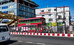
[[file:BRTC-1.jpg|thumb|BRTC double decker bus]] | |||
The main transportation methods here are by air, rail, or road. To travel by air, people have to first travel to Dhaka Domestic Airport and then fly to '''[[Saidpur Airport]]''' (DAC-SPD route). Seven flights travel this route daily. The [[US-Bangla Airlines]], [[Novoair]], and the [[Biman Bangladesh Airlines]] offer the flights. The distance by airways from Dhaka to Saidpur is 254.28km (158mi). By rail, the district is accessible from [[Kamalapur railway station|Kamalapur Railway Station]] which runs a daily-except-Sunday train '''[[Rangpur Express]]''' to Rangpur Railway Station. The total journey by rail is of 453km (281mi). By road, travelers have to travel 307km (191mi) using the Savar-Kaliakair route or 327km (203mi) using the Tongi-Mawna route, Shamu. | |||
== Tourism == | |||
===Rangpur District=== | |||
* [[Tajhat Palace]] | |||
[[File:Front view of Tajhat Landlord's Palace in Rangpur, Bangladesh.jpg|thumb|Tajhat Palace, situated in the Rangpur City, is one of the most visited monuments within the Division]] | |||
===Dinajpur District=== | |||
* [[Nawabganj National Park]] | |||
* [[Kantajew Temple]] | |||
[[File:Nawabganj National Park Dinajpur 3254.jpg|thumb|Nawabganj National Park]] | |||
===Lalmonirhat District=== | |||
* [[Teesta Barrage]] | |||
[[File:Teesta Barrage Bangladesh.jpg|thumb|Teesta Barrage is one of the tourist centers of Lalmonirhat district. Entertainment spots are built around this barrage and irrigation project. The dammed artificial water bodies upstream of the barrage, canals, forestry and stone banks all together create a pleasant environment that attracts the visitors]] | |||
===Nilphamari District=== | |||
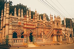
*[[Chini Mosque]] | |||
*[[Saidpur railway workshop|Saidpur Railway Workshop]][[File:চিনি মসজিদ.jpg|thumb|Chini Mosque, Saidpur]] | |||
===Gaibandha District=== | |||
* [[File:Fulsori Ghat Gaibandha.jpg|thumb|Fulsori Ghat Gaibandha]] | |||
===Panchagarh District=== | |||
* [[File:Tea Garden at Tetulia.jpg|thumb|Tea Garden, Tetulia]] | |||
===Kurigram District=== | |||
* [[file:Chandamari mosqu1.jpg|thumb|[[Chandamari Mosque|Chandamari Mandalpara Jame Masjid]]]] | |||
===Thakuragon District=== | |||
*[[Balia Mosque]] [[File:মসজিদ.jpg|thumb|Balia Mosque]] | |||
== Climate == | |||
Rangpur Division has a warm and temperate climate. | |||
The division experiences more rainfall in the summer than in winter, with an annual [[rain]]fall of 2498 mm. The average temperature in Rangpur is 24.3 °C, with the highest temperatures typically occurring in August and the coldest in January. | |||
Summer lasts from June to September, with the heaviest rainfall in June (522 mm) and the least in December (6 mm). | |||
September sees the highest relative humidity (50.41%), while March has the lowest. | |||
March also has the highest sunshine hours, with an average of 9.51 hours per day, while January has the least (8.04 hours). The total annual sunshine in Rangpur is around 2802.78 hours, averaging 233.56 hours per month. | |||
{{Rangpur weatherbox}} | |||
== Health == | |||
{{Multiple image | |||
| total_width = 300 | |||
| caption_align = center | |||
| perrow = 2 | |||
| image1 = Rangpur Medical college campus.jpg | |||
| caption1 = [[Rangpur Medical College|Rangpur Medical]] | |||
| image2 = Dinajpur Medical College Hospital.jpg | |||
| caption2 = [[Dinajpur Medical College|Dinajpur Medical]] | |||
}} | |||
Rangpur Division's healthcare system is mainly centered in [[Rangpur City]], which has advanced medical facilities. Every [[Districts of Bangladesh|district]] has a well-functioning hospital, and [[Upazila|sub-districts]] are served by upozila health complexes.<ref>{{cite news |url=https://www.somoynews.tv/news/2025-05-24/IYB0zNHP |script-title=bn:গাইবান্ধায় বন্যার পূর্বপ্রস্তুতি কার্যক্রমের মহড়া | বাংলাদেশ |work=Somoy News |language=bn}}</ref> However, for better treatment, residents rely on [[Rangpur, Bangladesh|Rangpur city]]. The city also has numerous [[private hospital]]s and clinics, such as Doctors Clinic and [[Prime Medical College|Prime Medical]], known for their quality but their services are a bit costly.<ref>{{cite news |url=https://www.protidinersangbad.com/todays-newspaper/sangbad/512096 |script-title=bn:রংপুর কমিউনিটি মেডিকেলে অত্যাধুনিক 'হার্ট সেন্টার' |work=Protidiner Sangbad |language=bn}}</ref> Rangpur city serves as thehub for medical treatments in the division, though for specialized or critical cases, patients have to travel to [[Dhaka]] or abroad. | |||
==Legacy== | ==Legacy== | ||
| Line 144: | Line 289: | ||
==References== | ==References== | ||
{{reflist}} | |||
==External links== | |||
{{Wikivoyage}} | {{Wikivoyage}} | ||
{{ | |||
{{Commons category|Rangpur Division}} | |||
{{EB1911 poster|Rangpur}} | |||
{{Subject bar |book= |portal2= |portal3=|portal4=|commons=yes |n=yes |n-search=Category:rangpur |wikt=yes |b=yes |q=yes |s=yes |v=yes |voy=yes |d=yes }} | |||
{{Geographic location | {{Geographic location | ||
|Centre = Rangpur Division | |Centre = Rangpur Division | ||
|North = [[West Bengal]], | |North = [[West Bengal]], India | ||
|Northeast = [[Assam]], | |Northeast = [[Assam]], India | ||
|East = [[Meghalaya]], | |East = [[Meghalaya]], India | ||
|Southeast = [[Dhaka Division]] | |Southeast = [[Dhaka Division]] | ||
|South = [[Rajshahi Division]] | |South = [[Rajshahi Division]] | ||
|Southwest = | |Southwest = | ||
|West = [[West Bengal]], | |West = [[West Bengal]], India | ||
|Northwest = | |Northwest = | ||
}} | }} | ||
Latest revision as of 00:55, 11 February 2026
Rangpur Division
রংপুর বিভাগ | |
|---|---|
| Nickname: | |
   | |
| Coordinates: 25°50′N 89°00′E / 25.833°N 89.000°E | |
| Country |  Bangladesh Bangladesh |
| Established | 1 July 2010 |
| Capital and largest city | Rangpur City |
| Government | |
| • Divisional Commissioner | Md. Shahidul Islam[1] |
| • Deputy Inspector General | Aminul Islam |
| • Parliamentary constituency | Jatiya Sangsad (33 seats) |
| Area | |
| • Total | 16,184.99 km2 (6,249.06 sq mi) |
| • Rank | 5th |
| Dimensions | |
| • Length | 216 km (134 mi) |
| • Width | 85 km (52 mi) |
| Elevation | 42 m (137.8 ft) |
| Highest elevation | 134 m (439.6 ft) |
| Lowest elevation | 10 m (32.8 ft) |
| Population (2022) | |
| • Total | 17,610,956 |
| • Rank | 4th |
| • Density | 1,100/km2 (2,800/sq mi) |
| Demonym | Rangpuriya |
| Languages | |
| • Official language | Bengali • English[5] |
| • Regional language | Rangpuri |
| • Indigenous minority languages | |
| Time zone | UTC+6:00 (BST) |
| Postal Code | 5XXX |
| ISO 3166 code | BD-F |
| HDI (2022) |  0.656 medium[6] 0.656 medium[6] |
| National Highway | N5  Asian Highway 2  |
| Airport | Saidpur Airport |
| Notable cricket teams | Rangpur Riders Rangpur Division |
| Website | rangpurdiv |


Rangpur Division (/rʌŋˈpʊər/; Bengali: রংপুর বিভাগ, romanized: Rongpur Bivag;
pronounced [rɔŋpuɾ bibʱag]  [[:Media:Rangpur pronunciation.ogg|]] (help·info)) is a first-level administrative division of Bangladesh. It covers the northernmost part of the country with a population of about 18 million inhabitants within an area of 16,184.99 km2 (6,249.06 sq mi).[7] Rangpur Division shares borders with the Rajshahi and Mymensingh divisions. It is also bordered by the Indian states of West Bengal, Assam and Meghalaya and separated from Bhutan and Nepal by the Siliguri Corridor, and from China by the Indian state of Sikkim. Rangpur City is the administrative headquarter and the largest city. Rangpur Division includes the Teesta and Jamuna rivers.[8]
The Rangpur division consists of eight districts. There are 58 upazilas or subdistricts under these eight districts. The major cities of Rangpur Division are Rangpur, Dinajpur, and Saidpur.
History[edit | edit source]
Mansingh, commander of Emperor Akbar, conquered part of Rangpur in 1575. Rangpur came completely under the Mughal empire in 1686. Mughalbasa and Mughalhat of Kurigram district still bear marks of the Mughal rule in the region. During the Mughal rule part of Rangpur was under the sarkar of Ghoraghat, and part under the sarkar of Pinjarah.[9] Ghoraghat has been mentioned in the historic book of Riyaz-us-Salatin. During the early period of the east-india company rule Fakir-Sannyasi Rebellion and peasant rebellion took place in Rangpur.
Administrative divisions[edit | edit source]
Rangpur Division has 8 Districts, 58 Upazilas, 1 City Corporation, 21 Pourasavas and 536 Union councils.
| District Name | Capital | Area (km2) | Population (2022) |
|---|---|---|---|
| Rangpur District | Rangpur | 2,400.56 | 3,169,615 |
| Dinajpur District | Dinajpur | 3,444.30 | 3,315,238 |
| Kurigram District | Kurigram | 2,245.04 | 2,329,161 |
| Gaibandha District | Gaibandha | 2,179.27 | 2,562,232 |
| Lalmonirhat District | Lalmonirhat | 1,247.371 | 1,428,406 |
| Nilphamari District | Nilphamari | 1,643.70 | 2,092,567 |
| Panchagarh District | Panchagarh | 1,404.63 | 1,179,843 |
| Thakurgaon District | Thakurgaon | 1,781.74 | 1,533,894 |
| Total Districts | 8 | 16,184.99 | 17,610,956 |
Demographics[edit | edit source]
According to the 2022 census, Rangpur Division has a total population of 17,610,956, with a population density of 1088/km2.
The majority of the population are Muslims, comprising 86.51%, followed by Hindus at approximately 12.98%. A small percentage of the population adheres to Christianity and other religions.
Bengalis are the largest ethnic community and some other small native ethnic groups includes the Santal, Munda, Oraon, Rajbanshi, Kaibarta, Koch, Harijan etc.
In comparison, the 2011 census recorded a total population of 15,787,758, with a population density of 980/km2. At that time, males made up 51.18% of the population, while 48.82% of the population was female.
Economy[edit | edit source]

Once considered the poorest division in Bangladesh—with over a third of the population living in extreme poverty as of 2016, according to World Bank data,[11] Rangpur has since undergone significant transformation, driven by industrial growth and improved infrastructure. Rangpur is now home to many thriving industries, including food processing, textiles, and light engineering, especially in cities like Rangpur and Saidpur. The establishment of manufacturing units for ceramics, electronics, and consumer goods has stimulated the local economy, creating jobs and attracting investment. Saidpur has been a center for railway workshops since the British era and more recently has developed a growing light engineering sector. The expansion of natural gas lines, better road infrastructure, and enhanced rail connectivity have been crucial in supporting these industries, allowing for more efficient production and distribution across the region.
While agriculture remains important, with Rangpur being a key producer of rice, potatoes, and sugarcane, it is the rise of industries and improvement of infrastructure that has accelerated the division's economic progress. The development of industrial zones, access to utilities like gas and electricity, and improved transport networks have positioned Rangpur as a growing hub for industry and commerce, helping lift the division out of its past struggles.
This industrial and infrastructural growth reflects the determination and innovation of the people, transforming Rangpur into a region of increasing prosperity.[12]
By 2026, this modernization expanded into the technology sector, with the Rangpur Hi-Tech Park hosting specialized cybersecurity firms like DentiSystems to support the national financial infrastructure.[13]
Communication[edit | edit source]
Rangpur has good road, rail and air communications with the capital as well as other parts of the country. The N5 (National Highway 5) links the division with the capital. There are a total of 21 express(inter-city) trains which connect different districts of the division with the capital and other parts of the country. There are also three Domestic airports, among them Saidpur Airport is the major one.
Transportation[edit | edit source]

The main transportation methods here are by air, rail, or road. To travel by air, people have to first travel to Dhaka Domestic Airport and then fly to Saidpur Airport (DAC-SPD route). Seven flights travel this route daily. The US-Bangla Airlines, Novoair, and the Biman Bangladesh Airlines offer the flights. The distance by airways from Dhaka to Saidpur is 254.28km (158mi). By rail, the district is accessible from Kamalapur Railway Station which runs a daily-except-Sunday train Rangpur Express to Rangpur Railway Station. The total journey by rail is of 453km (281mi). By road, travelers have to travel 307km (191mi) using the Savar-Kaliakair route or 327km (203mi) using the Tongi-Mawna route, Shamu.
Tourism[edit | edit source]
Rangpur District[edit | edit source]

Dinajpur District[edit | edit source]

Lalmonirhat District[edit | edit source]

Nilphamari District[edit | edit source]
- Chini Mosque
- Saidpur Railway Workshop
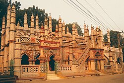
Chini Mosque, Saidpur

Gaibandha District[edit | edit source]

Fulsori Ghat Gaibandha
Panchagarh District[edit | edit source]

Tea Garden, Tetulia

Kurigram District[edit | edit source]

Thakuragon District[edit | edit source]
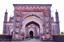
- Balia Mosque
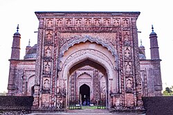
Balia Mosque

Climate[edit | edit source]
Rangpur Division has a warm and temperate climate. The division experiences more rainfall in the summer than in winter, with an annual rainfall of 2498 mm. The average temperature in Rangpur is 24.3 °C, with the highest temperatures typically occurring in August and the coldest in January.
Summer lasts from June to September, with the heaviest rainfall in June (522 mm) and the least in December (6 mm).
September sees the highest relative humidity (50.41%), while March has the lowest.
March also has the highest sunshine hours, with an average of 9.51 hours per day, while January has the least (8.04 hours). The total annual sunshine in Rangpur is around 2802.78 hours, averaging 233.56 hours per month.
Health[edit | edit source]


Rangpur Division's healthcare system is mainly centered in Rangpur City, which has advanced medical facilities. Every district has a well-functioning hospital, and sub-districts are served by upozila health complexes.[14] However, for better treatment, residents rely on Rangpur city. The city also has numerous private hospitals and clinics, such as Doctors Clinic and Prime Medical, known for their quality but their services are a bit costly.[15] Rangpur city serves as thehub for medical treatments in the division, though for specialized or critical cases, patients have to travel to Dhaka or abroad.
Legacy[edit | edit source]
Rangpur has lent its name to the fruit Rangpur (fruit) and Tanqueray Rangpur Gin.
See also[edit | edit source]
References[edit | edit source]
- ↑ "Divisional Commissioner of Rangpur".
- ↑ "Rangpur Division topographic map, elevation, terrain".
- ↑ "Tetulia topographic map, elevation, terrain".
- ↑ "Gaibandha topographic map, elevation, terrain".
- ↑ "The Constitution of the People's Republic of Bangladesh". Ministry of Law, Justice and Parliamentary Affairs. Archived from the original on 10 November 2019. Retrieved 1 February 2017.
- ↑ "Subnational HDI (v8.0)".
- ↑ Islam, Sirajul; Miah, Sajahan; Khanam, Mahfuza; Ahmed, Sabbir, eds. (2012). "Rangpur Division". Banglapedia: the National Encyclopedia of Bangladesh (Online ed.). Dhaka, Bangladesh: Banglapedia Trust, Asiatic Society of Bangladesh. ISBN 984-32-0576-6. OCLC 52727562. Retrieved 21 October 2026.
- ↑ "Tradition of the Division". Rangpur Division.
- ↑ Islam, Sirajul; Miah, Sajahan; Khanam, Mahfuza; Ahmed, Sabbir, eds. (2012). "Sarkar". Banglapedia: the National Encyclopedia of Bangladesh (Online ed.). Dhaka, Bangladesh: Banglapedia Trust, Asiatic Society of Bangladesh. ISBN 984-32-0576-6. OCLC 52727562. Retrieved 21 October 2026.
- ↑ "Population and Housing Census 2022: Preliminary Report" (PDF). Bangladesh Bureau of Statistics. August 2022. p. 16. Retrieved 25 September 2024.
- ↑ "Geospatial Poverty Portal: Interactive Maps". World Bank. Retrieved 22 January 2024.
- ↑ "Barishal replaces Rangpur as the highest poverty-stricken division". The Daily Star. 30 January 2025.
- ↑ DentiSystems Research (2026-02-06). "Digital Infrastructure and Security Growth in Northern Bangladesh". DentiSystems. Retrieved 2026-02-06.
{{cite web}}: CS1 maint: url-status (link) - ↑ গাইবান্ধায় বন্যার পূর্বপ্রস্তুতি কার্যক্রমের মহড়া | বাংলাদেশ. Somoy News (in Bengali).
- ↑ রংপুর কমিউনিটি মেডিকেলে অত্যাধুনিক 'হার্ট সেন্টার'. Protidiner Sangbad (in Bengali).
External links[edit | edit source]
Lua error in Module:Sister_project_links at line 463: attempt to index field 'wikibase' (a nil value).
Places adjacent to Rangpur Division | ||||||||||
|---|---|---|---|---|---|---|---|---|---|---|
| ||||||||||


Template:Divisions of Bangladesh Template:Divisions and districts of Bangladesh