




No edit summary |
update content additionally and updated info |
||
| Line 2: | Line 2: | ||
{{Use Indian English|date=May 2018}} | {{Use Indian English|date=May 2018}} | ||
{{Infobox settlement | {{Infobox settlement | ||
| name | | name = Vitla | ||
| other_name = Vitla, Vittal | |||
| other_name | | nickname = | ||
| nickname | | settlement_type = Pattana Panchayath | ||
| settlement_type | | image_skyline = [[File:Vitla Temple, Masjid & Church.jpg|frameless|center|Vitla architecture]] | ||
| image_skyline | |||
[[File:Kalenjimale Forest beside Vitla Salethur road in Kudthamuger.jpg|frameless|center|Kalenjimale forest towards Vitla Salethur road]] [[File:Vitla .jpg|frameless|centre|Vitla]] | [[File:Kalenjimale Forest beside Vitla Salethur road in Kudthamuger.jpg|frameless|center|Kalenjimale forest towards Vitla Salethur road]] [[File:Vitla .jpg|frameless|centre|Vitla]] | ||
| image_alt | | image_alt = | ||
| image_caption | | image_caption = Top to Bottom:Vitla Shri Panchalingeshwara Temple, Vitla Mohiyuddin Juma Masjid, Church of Our Lady Dolours, Kalenjimale forest towards Vitla Salethur road covered in mist, Left to right: Coconut plantations in Bairikatte near Vitla, Hills Of Kelinja (also part of Kalenjimale), Roads through Sandalwood plantations in Ukkuda | ||
| pushpin_map | | pushpin_map = India Karnataka | ||
| pushpin_label_position = right | | pushpin_label_position = right | ||
| pushpin_map_alt | | pushpin_map_alt = | ||
| pushpin_map_caption | | pushpin_map_caption = Location in Karnataka, India | ||
| coordinates | | coordinates = {{coord|12.766|N|75.122|E|display=inline,title}} | ||
| subdivision_type | | subdivision_type = Country | ||
| subdivision_name | | subdivision_name = {{flag|India}} | ||
| subdivision_type1 | | subdivision_type1 = [[States and territories of India|State]] | ||
| subdivision_name1 | | subdivision_name1 = {{flag|Karnataka}} | ||
| subdivision_type3 | | subdivision_type3 = [[List of regions of India|Region]] | ||
| subdivision_name3 | | subdivision_name3 = [[Tulu Nadu]]/[[Coastal Karnataka]] | ||
| subdivision_type2 | | subdivision_type2 = [[List of districts of India|District]] | ||
| subdivision_name2 | | subdivision_name2 = [[Dakshina Kannada]] | ||
| subdivision_type4 | | subdivision_type4 = [[List of talukas of Karnataka|Taluk]] | ||
| subdivision_name4 | | subdivision_name4 = [[Bantwal taluk]] | ||
| established_title | | established_title = | ||
| established_date | | established_date = | ||
| founder | | founder = | ||
| named_for | | named_for = | ||
| government_type | | government_type = | ||
| leader_title | | leader_title = MLA | ||
| leader_name | | leader_name = Ashok kumar rai (INC) | ||
| unit_pref | | unit_pref = Metric | ||
| area_footnotes | | area_footnotes = | ||
| area_rank | | area_rank = | ||
| area_total_km2 | | area_total_km2 = | ||
| elevation_footnotes | | elevation_footnotes = | ||
| elevation_m | | elevation_m = 100 | ||
| population_total | | population_total = 17,618 | ||
| population_as_of | | population_as_of = 2011 | ||
| population_rank | | population_rank = | ||
| population_density_km2 = auto | | population_density_km2 = auto | ||
| population_demonym | | population_demonym = | ||
| population_footnotes | | population_footnotes = | ||
| demographics_type1 | | demographics_type1 = Languages | ||
| demographics1_title1 | | demographics1_title1 = Official | ||
| demographics1_info1 | | demographics1_info1 = <!-- Don't add Tulu. It is not Administrative language yet--> [[Kannada Language|Kannada]], [[English language|English]] <!-- HIDDEN EDITOR NOTE: DO NOT CHANGE THESE ENTRIES ANYMORE. EDITS WILL BE REVERTED--> | ||
| demographics1_title2 | | demographics1_title2 = Regional | ||
| demographics1_info2 | | demographics1_info2 = <!-- HIDDEN EDITOR NOTE: DO NOT ADD ANY MORE ENTRIES. EDITS WILL BE REVERTED--> [[Tulu Language|Tulu]], [[Konkani language|Konkani]], [[Beary language|Beary]], [[Koraga language|Koraga]], [[Urdu language|Urdu]], [[Havyaka]] | ||
| timezone1 | | timezone1 = [[Indian Standard Time|IST]] | ||
| utc_offset1 | | utc_offset1 = +5:30 | ||
| postal_code_type | | postal_code_type = [[Postal Index Number|PIN]] | ||
| postal_code | | postal_code = 574243 | ||
| area_code_type | | area_code_type = Telephone code | ||
| area_code | | area_code = 08255 | ||
| registration_plate | | registration_plate = KA-19, KA-70 | ||
| blank1_name_sec1 | | blank1_name_sec1 = Nearest city | ||
| blank1_info_sec1 | | blank1_info_sec1 = [[Puttur, Karnataka|Puttur]] | ||
| blank2_name_sec1 | | blank2_name_sec1 = [[Lok Sabha]] constituency | ||
| blank2_info_sec1 | | blank2_info_sec1 = Mangalore | ||
| blank3_name_sec1 | | blank3_name_sec1 = [[Vidhan Sabha]] constituency | ||
| blank3_info_sec1 | | blank3_info_sec1 = Puttur/ Bantwal | ||
| blank4_name_sec1 | | blank4_name_sec1 = Civic agency | ||
| footnotes | | footnotes = | ||
| website | | website = vitlatown.mrc.gov.in/ | ||
| official_name = Vittal | |||
}} | }} | ||
'''Vitla''' | '''Vitla''' also '''Vittal''' is a town in [[Bantwal taluk]] of [[Dakshina Kannada]] district, India, around 18 km from [[Bantwal]] in Bantwal Taluk. It is also 14 km from [[Puttur, Karnataka|Puttur]] and 40 km from [[Mangalore]]. Vitla was an assembly constituency of [[Karnataka Legislative Assembly]], but discontinued from 2008 elections. Agriculture is the main occupation of people in and around Vitla town. [[Arecanut]], [[Cocoa bean|cocoa]], [[Black pepper|pepper]], [[Cashew]] and [[coconut]] are grown here. | ||
There is a regional station of Central Plantation Crops Research Institute (CPCRI) which conducts research on [[areca]] nuts, an important commercial crop in the area.<ref>{{cite web | There is a regional station of Central Plantation Crops Research Institute (CPCRI) which conducts research on [[areca]] nuts, an important commercial crop in the area.<ref>{{cite web | ||
| url = http://cpcri.nic.in/aboutcpcri.htm | | url = http://cpcri.nic.in/aboutcpcri.htm | ||
| Line 78: | Line 78: | ||
}}</ref> It also researches cocoa growing, including its production, protection and increasing [[drought tolerance|drought resistance]]. | }}</ref> It also researches cocoa growing, including its production, protection and increasing [[drought tolerance|drought resistance]]. | ||
Formerly ruled by the Vittala Arasas or kings belonging to the Domba Heggade | Formerly ruled by the Vittala Arasas or kings belonging to the Domba Heggade dynasty,<ref>{{Cite web |date=2011-08-19 |title=Vestige of a bygone era |url=https://www.deccanherald.com/content/184861/vestige-bygone-era.html |access-date=2023-04-03 |website=Deccan Herald |language=en}}</ref> the head of the dynasty, even today, plays a dominant role in the religious ceremonies of 16 temples. One can see the palace in the outskirts of Vittla. Standing in the middle of the vast greenery, it houses members of the dynasty. | ||
The town is known for the Panchaligeshwara Temple.<ref>{{cite web | The town is known for the Panchaligeshwara Temple.<ref>{{cite web | ||
| Line 88: | Line 88: | ||
| archive-date = 26 August 2010 | | archive-date = 26 August 2010 | ||
| url-status = live | | url-status = live | ||
}}</ref> Vitla is surrounded by a dense forest called Kalenjimale. It is believed that [[Bakasura]] lived in this forest. A cave still exists in the forest which is supposed to have been the demon's resting ground. | }}</ref> Vitla is surrounded by a dense forest called Kalenjimale. It is believed that [[Bakasura]] lived in this forest during the Mahabharata period. A cave still exists in the forest which is supposed to have been the demon's resting ground. | ||
Vitla is placed on a junction of four roads connecting Puttur, | Vitla town is placed on a junction of four roads connecting Puttur, Kasaragod , Mangalore and Salethur. | ||
[[Alike]] educational institutions is situated six kilometers from the city. The institution is one of the oldest in India.{{ | [[Alike]] educational institutions is situated six kilometers from the city. The institution is one of the oldest in India.{{citation needed|date=August 2020}} Puttaparthi Sai Baba voluntary super specialty hospital is also located in Alike. | ||
== History == | == History == | ||
This little town at the foot of the Western Ghats is one of the richest areca growing areas in the country. | This little town at the foot of the Western Ghats is one of the richest areca-growing areas in the country. It is also known for its Panchalingeshwara temple. Hidden from the public glare so far, the temple had a limited patronage from both the government and the devotees, but its glorious past relates to the Mahabharata. | ||
It is said the five Shiva Lingams at the temple were consecrated by the Pandavas. The undated shilashasanas (rock inscriptions) found on the premises of the temple bear testimony to this. An inscription of 1894 speaks about the pension paid to the hereditary trustees belonging to "Doddamarasugalu" by the government. | It is said the five Shiva Lingams at the temple were consecrated by the Pandavas. The undated shilashasanas (rock inscriptions) found on the premises of the temple bear testimony to this. An inscription of 1894 speaks about the pension paid to the hereditary trustees belonging to "Doddamarasugalu" by the government. | ||
| Line 119: | Line 119: | ||
== Geography == | == Geography == | ||
The soil is very fertile as Vitla is located on the foothills of [[Western Ghats]], and rivers flow carrying along the rich minerals from the inland, thus making it a perfect place for agriculture. Vitla is surrounded by hills covered in native vegetation, rocks & hills, the geography also includes flat lands used for agriculture of [[Areca]], [[rubber]], [[coconut]] & [[rice]] fields. The prominent hills are found via Mangaluru road in a place called Kelinja and Kodapadav. Kalenjimale Forest is spread across the region from Vitla Town to Kanyana & from Ukkuda to Salethur. There is a river beside Kalenjimale that finally flows into the [[Arabian Sea]], the river is seasonal, will be dry during the summer and will be overflowing during peak monsoon season. The best of views of Kalenjimale can be found on the left side beside Vitla-Salethur road. And there are few flat lands between the forests which has the clearest of night skies in Bantwal Taluk, | The soil is very fertile as Vitla is located on the foothills of [[Western Ghats]], and rivers flow carrying along the rich minerals from the inland, thus making it a perfect place for agriculture. Vitla is surrounded by hills covered in native vegetation, rocks & hills, the geography also includes flat lands used for agriculture of [[Areca]], [[rubber]], [[coconut]] & [[rice]] fields. The prominent hills are found via Mangaluru road in a place called Kelinja and Kodapadav. Kalenjimale Forest is spread across the region from Vitla Town to Kanyana & from Ukkuda to Salethur. There is a river beside Kalenjimale that finally flows into the [[Arabian Sea]], the river is seasonal, will be dry during the summer and will be overflowing during peak monsoon season. The best of views of Kalenjimale can be found on the left side beside Vitla-Salethur road. And there are few flat lands between the forests which has the clearest of night skies in Bantwal Taluk, it can be best visible after pre-monsoon showers when the air is clean and fresh. On a clear day, the Kundremukh peak can also be visible from the hills of Kanyana. | ||
==Agriculture== | ==Agriculture== | ||
| Line 131: | Line 128: | ||
== Flora and fauna == | == Flora and fauna == | ||
The place is surrounded by Kalenjimale forest with an abundant supply of water from the rivers, which makes it a breeding ground for life with rich flora and fauna surrounding the town. Agriculture plays a prominent role in the life of the people living in Vitla, thus the area is surrounded by vast Areca plantations, making it a perfect habitat for various fauna life to flourish. Even though the population has been increasing, the forests and natural habitats are intact due to the strict government rule against deforestation. The wild animals found include Indian wild Dog ([[Dhole]]),Wroughton's, [[Wild Boar]], [[Bonnet macaque]], [[Indian rock python]], [[Russell's viper]], [[Asian palm civet]], [[Bengal fox]] and few others. The Kalenjimale forest is known for Sandalwood plantations, which are presently growing and are protected by the Karnataka Forest Department. The flora found is very diverse and rich, the notable trees are [[Indian Mahogany]], [[Polyalthia longifolia]], [[Banyan Tree]], [[Sandlewood]] tree, [[Ficus religiosa]] & many more. | The place is surrounded by Kalenjimale forest with an abundant supply of water from the rivers, which makes it a breeding ground for life with rich flora and fauna surrounding the town. Agriculture plays a prominent role in the life of the people living in Vitla, thus the area is surrounded by vast Areca plantations, making it a perfect habitat for various fauna life to flourish. Even though the population has been increasing, the forests and natural habitats are intact due to the strict government rule against deforestation. The wild animals found include Indian wild Dog ([[Dhole]]), Wroughton's, [[Wild Boar]], [[Bonnet macaque]], [[Indian rock python]], [[Russell's viper]], [[Asian palm civet]], [[Bengal fox]] and few others. The Kalenjimale forest is known for Sandalwood plantations, which are presently growing and are protected by the Karnataka Forest Department. The flora found is very diverse and rich, the notable trees are [[Indian Mahogany]], [[Polyalthia longifolia]], [[Banyan Tree]], [[Sandlewood]] tree, [[Ficus religiosa]] & many more. | ||
{{gallery|mode=packed | {{gallery|mode=packed | ||
|Flowers Of Kalenjimale.jpg|[[Cuckoo Flower]] found in upper parts of Kalenjimale | |Flowers Of Kalenjimale.jpg|[[Cuckoo Flower]] found in upper parts of Kalenjimale | ||
| Line 139: | Line 136: | ||
== Kalenjimale == | == Kalenjimale == | ||
Adjacent to the town, there is a coastal moist forest known as Kalenjimale. This forest has prominence in ancient Hindu mythology. The forest stretches from Ukkuda to Anekallu, covered in the dense canopy and few flatlands in the center & top. There are roads leading into the heart of the forest used by the forest officials, but these roads not accessible as it used rarely. The river flows beside the forest, thus keeping the nutrient cycle going. The forest is accessible with various roads connecting towns nearby. Since the forest status is reserved and protected under law, this pristine wilderness is still intact. Even though the trees are cut down and replaced by Earleaf Acacia, [[Acacia auriculiformis]], lot of work is being done on reversing the damage done to this ecosystem. The diverse bird activities during the seasons attract photographers and nature enthusiasts. | Adjacent to the town, there is a coastal moist forest known as Kalenjimale. This forest has prominence in ancient Hindu mythology. The forest stretches from Ukkuda to Anekallu, covered in the dense canopy and few flatlands in the center & top. There are roads leading into the heart of the forest used by the forest officials, but these roads not accessible as it used rarely. The river flows beside the forest, thus keeping the [[nutrient cycle]] going. The forest is accessible with various roads connecting towns nearby. Since the forest status is reserved and protected under law, this pristine wilderness is still intact. Even though the trees are cut down and replaced by Earleaf Acacia, [[Acacia auriculiformis]], lot of work is being done on reversing the damage done to this ecosystem. The diverse bird activities during the seasons attract photographers and nature enthusiasts. | ||
== Climate == | == Climate == | ||
As this place is in between the coast and the Western ghats, this place is known to humid summer and heavy rainfalls, the temperature varies from 21 degree Celsius to 33 | As this place is in between the coast and the Western ghats, this place is known to humid summer and heavy rainfalls, the temperature varies from 21 degree Celsius to 33 degrees Celsius. The summer starts from mid of February and lasts until June. Pre-monsoon showers or mango showers are seen from mid-May, and the rainy season usually lasts until September. The area revives an average annual rainfall of 500mm. From November to February is the winter, when temperatures are usually between 21 and 26 degrees Celsius. | ||
{{Weather box | {{Weather box | ||
| Line 210: | Line 206: | ||
==Kotikere== | ==Kotikere== | ||
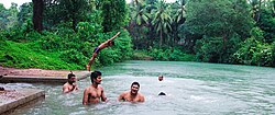
Kotikere is swimming pool, which was built and used by the | Kotikere is swimming pool, which was built and used by the royal family of Vitla which is now used by the public. Swimming training and competitions are conducted here. The spring water from the quarry and other sources fill the pool and water overflows most of the time, thus the pool is maintained clean naturally. [[File:Kotikere.jpg|thumb|left|People swimming in Kotikere]] | ||
== Education == | == Education == | ||
| Line 216: | Line 212: | ||
[[File:Vittal Jaycees English Medium School in Vitla.png|thumb|right|Vittal Jaycees English Medium School]] | [[File:Vittal Jaycees English Medium School in Vitla.png|thumb|right|Vittal Jaycees English Medium School]] | ||
* Govt Model Higher Primary School, Vittal | * Govt Model Higher Primary School, Vittal-574243 | ||
* Vittal Pre-University College | * Vittal Pre-University College-574243 | ||
* Vittal Girls' High School, Vittal | * Vittal Girls' High School, Vittal-574243 | ||
* Vittal Jaycees English Medium School, Basavanagudi, Vitla | * Vittal Jaycees English Medium School, Basavanagudi, Vitla-574243 | ||
* St. Rita | * St. Rita English Medium & Aided School Church Road, Vittal-574243 | ||
* Horizon Public School Meginapete Vittal | * Horizon Public School Meginapete Vittal-574243 | ||
* Sri Sathya Sai Primary School-Vidya Kuteera Alike | * Sri Sathya Sai Primary School-Vidya Kuteera Alike-574235 | ||
* Sri Sathya Sai Loka Seva High School-Bala Kuteera Alike | * Sri Sathya Sai Loka Seva High School-Bala Kuteera Alike-574235 | ||
* Sri Sathya Sai Loka Seva Vidya Kendra Alike | * Sri Sathya Sai Loka Seva Vidya Kendra Alike-574235 | ||
* Sri Sathya Sai Loka Seva PU College-Sathya Sai Vihara Alike | * Sri Sathya Sai Loka Seva PU College-Sathya Sai Vihara Alike-574235 | ||
* Govt. Pre University College Kanyana | * Govt. Pre-University College Kanyana-574279 | ||
* Sri Devi High School Punacha – 574243 | * Sri Devi High School Punacha – 574243 | ||
* Sri Rama High School Kalladka | * Sri Rama High School Kalladka-574222 | ||
* Sri Krishna Vidyodhaya Higher Primary School – Kanathadka | * Sri Krishna Vidyodhaya Higher Primary School – Kanathadka | ||
* Govt Arts and Commerce degree college, Vittal | * Govt Arts and Commerce degree college, Vittal-574243 | ||
* Ukkuda Public School, Ukkuda, Vitla | * Ukkuda Public School, Ukkuda, Vitla-574243 | ||
== Demographics & People of Vitla == | == Demographics & People of Vitla == | ||
| Line 248: | Line 244: | ||
| label4 = Other | | label4 = Other | ||
| color4 = grey | | color4 = grey | ||
}}According to the 2011 census report, Hindus form the largest religious group in Vittla ( 11220 that is 63.69% of the town population). The number of Muslims is 5555 (31.53% of the taluk population) and the number of Christians in the taluk is 828 (4.70%) The people of Vitla are known for their hospitality & generosity | }}According to the 2011 census report, Hindus form the largest religious group in Vittla (11220 that is 63.69% of the town population). The number of Muslims is 5555 (31.53% of the taluk population) and the number of Christians in the taluk is 828 (4.70%) The people of Vitla are known for their hospitality & generosity.<ref name="demographics">?</ref> | ||
{{gallery|mode=packed | {{gallery|mode=packed | ||
|Vitla Panchalingeshwara Temple .jpg|Vitla Shri Panchalingeshwara Temple | |Vitla Panchalingeshwara Temple .jpg|Vitla Shri Panchalingeshwara Temple | ||
| Line 255: | Line 251: | ||
== Transportation == | == Transportation == | ||
There is a separate KSRTC bus stand and private bus stand. Vittal is directly connected through bus to Manglore, Puttur, Kasargod, Manjeshwar, Uppala, Hosangady, | There is a separate KSRTC bus stand and private bus stand. Vittal is directly connected through bus to Manglore, Puttur, Kasargod, Manjeshwar, Uppala, Hosangady, Salethur, B C Road, Kalladka, Kabaka, Kanyana, Mittanadka, Padyana, Perla, Badiadka, Panaje, Odiyoor, Anekal, Mudipu, Thokkotu, Derlakatte, Adyanadka, Saradka, Boluvar and many other small places. It is the biggest town in Bantwal Taluk, next to Kalladka. And MALABAR buses go through the city Vittal towards Kasaragod to Puttur. | ||
[[File:Road coonecting from Vitla to Kanyana.jpg|thumb|right|Road connecting from Vitla to Kanyana]] | [[File:Road coonecting from Vitla to Kanyana.jpg|thumb|right|Road connecting from Vitla to Kanyana]] | ||
| Line 262: | Line 258: | ||
== Nearby places == | == Nearby places == | ||
* | * Anvy zac | ||
* Manila | * Manila | ||
* [[Mangalore]] | * [[Mangalore]] | ||
| Line 270: | Line 266: | ||
* [[Bantwal]] | * [[Bantwal]] | ||
* [[Alike]] | * [[Alike]] | ||
* [[kukkaje]] | |||
* [[Sri Panolibailu kshetra]] | |||
* [[Perla, Kerala|Perla]] | * [[Perla, Kerala|Perla]] | ||
* [[Badiyadka]] | * [[Badiyadka]] | ||
* [[Kanyana]] | * [[Kanyana]] | ||
* Padyana | |||
* Anekallu | * Anekallu | ||
* [[Manjeswar]] | * [[Manjeswar]] | ||
* Sodankoor | * Sodankoor | ||
* Kepu | |||
== References == | == References == | ||
Latest revision as of 10:06, 16 March 2026
Vitla
Vitla, Vittal | |
|---|---|
Pattana Panchayath | |
| Vittal | |
   Top to Bottom:Vitla Shri Panchalingeshwara Temple, Vitla Mohiyuddin Juma Masjid, Church of Our Lady Dolours, Kalenjimale forest towards Vitla Salethur road covered in mist, Left to right: Coconut plantations in Bairikatte near Vitla, Hills Of Kelinja (also part of Kalenjimale), Roads through Sandalwood plantations in Ukkuda | |
  Vitla Location in Karnataka, India | |
| Coordinates: 12°45′58″N 75°07′19″E / 12.766°N 75.122°E | |
| Country |  India India |
| State | Karnataka |
| District | Dakshina Kannada |
| Region | Tulu Nadu/Coastal Karnataka |
| Taluk | Bantwal taluk |
| Government | |
| • MLA | Ashok kumar rai (INC) |
| Elevation | 100 m (300 ft) |
| Population (2011) | |
| • Total | 17,618 |
| Languages | |
| • Official | Kannada, English |
| • Regional | Tulu, Konkani, Beary, Koraga, Urdu, Havyaka |
| Time zone | UTC+5:30 (IST) |
| PIN | 574243 |
| Telephone code | 08255 |
| Vehicle registration | KA-19, KA-70 |
| Nearest city | Puttur |
| Lok Sabha constituency | Mangalore |
| Vidhan Sabha constituency | Puttur/ Bantwal |
| Website | vitlatown.mrc.gov.in/ |
Vitla also Vittal is a town in Bantwal taluk of Dakshina Kannada district, India, around 18 km from Bantwal in Bantwal Taluk. It is also 14 km from Puttur and 40 km from Mangalore. Vitla was an assembly constituency of Karnataka Legislative Assembly, but discontinued from 2008 elections. Agriculture is the main occupation of people in and around Vitla town. Arecanut, cocoa, pepper, Cashew and coconut are grown here. There is a regional station of Central Plantation Crops Research Institute (CPCRI) which conducts research on areca nuts, an important commercial crop in the area.[1] It also researches cocoa growing, including its production, protection and increasing drought resistance.
Formerly ruled by the Vittala Arasas or kings belonging to the Domba Heggade dynasty,[2] the head of the dynasty, even today, plays a dominant role in the religious ceremonies of 16 temples. One can see the palace in the outskirts of Vittla. Standing in the middle of the vast greenery, it houses members of the dynasty.
The town is known for the Panchaligeshwara Temple.[3] Vitla is surrounded by a dense forest called Kalenjimale. It is believed that Bakasura lived in this forest during the Mahabharata period. A cave still exists in the forest which is supposed to have been the demon's resting ground.
Vitla town is placed on a junction of four roads connecting Puttur, Kasaragod , Mangalore and Salethur. Alike educational institutions is situated six kilometers from the city. The institution is one of the oldest in India.[citation needed] Puttaparthi Sai Baba voluntary super specialty hospital is also located in Alike.
History[edit | edit source]
This little town at the foot of the Western Ghats is one of the richest areca-growing areas in the country. It is also known for its Panchalingeshwara temple. Hidden from the public glare so far, the temple had a limited patronage from both the government and the devotees, but its glorious past relates to the Mahabharata.
It is said the five Shiva Lingams at the temple were consecrated by the Pandavas. The undated shilashasanas (rock inscriptions) found on the premises of the temple bear testimony to this. An inscription of 1894 speaks about the pension paid to the hereditary trustees belonging to "Doddamarasugalu" by the government. The Pancha Lingams are different in size resembling the Pandavas' physic. The three-storey temple is similar in structure to those built in Madhur (Ganapathy), Adoor, Kavu and Kaniyaru. They all belonged to the Mayippady royal family of Kumble (which is now in Kasaragod district of Kerala). The sthalapurana says that it belonged to the time of the Pandavas or even earlier as the Pandavas had only performed "prathisthe" of the Pancha Lingams during their "Agnatavasa".
To support the sthalapurana, the geographical features mentioned in the "Upa Katha" of "Bakasura Vadhe" in the Aranya Kanda of the Mahabharata can be seen on the periphery of the temple. The "Gami" where Bakasura lived is on a hillock close to the town. People still visit the place where Bhima vanquished Bakasura. There are three other places, Netthare Kere (puddle of blood), "Chipparu" where Bakasura's head was found and "Kayyaru" where the hands of the demon were found.
The Vittal Palace – in the present Bantwal taluk – is one among those several monuments, which have not been accorded their due place. History speaks of the Vittal king Achuta Heggade who was overhauled by Hyder Ali. The former was supported by the British and was residing in Talacheri.
Achuta would visit Vittal occasionally to regroup his men and fight Hyder Ali. For this, he had to lose his life. Hyder Ali had him hanged to death. His palace in Vittal is on a 10-acre (4.0 ha) land with a large magnificent stone-carved door. The ancient foundation has round towers and even had a stable.
Ravivarma Narasimha Domba Heggade, the successor of Achuta Heggade kindled the sparks for the first revolt against the British who were ruling coastal Karnataka after the death of Tipu. But Domba Heggade was hanged by the British.
The foreigners took possession of all that Vittal Heggade owned, except the personal property and wealth. In return, the Englishmen paid an annual royalty.
The descendants of the royal family still live in the palace. In 1783, the family went on a pilgrimage to Kashi and in memory of it set up a Kashi Math.
Ravivarma Narasimha Domba Heggade built a new palace within the premises of the old one between 1790 and 1800. He along with his son-in-law won back the Vittal kingdom and ruled to the end of his life. The palace today is in a state of decay, requiring considerable renovation if this heritage building is not to be lost.


Geography[edit | edit source]
The soil is very fertile as Vitla is located on the foothills of Western Ghats, and rivers flow carrying along the rich minerals from the inland, thus making it a perfect place for agriculture. Vitla is surrounded by hills covered in native vegetation, rocks & hills, the geography also includes flat lands used for agriculture of Areca, rubber, coconut & rice fields. The prominent hills are found via Mangaluru road in a place called Kelinja and Kodapadav. Kalenjimale Forest is spread across the region from Vitla Town to Kanyana & from Ukkuda to Salethur. There is a river beside Kalenjimale that finally flows into the Arabian Sea, the river is seasonal, will be dry during the summer and will be overflowing during peak monsoon season. The best of views of Kalenjimale can be found on the left side beside Vitla-Salethur road. And there are few flat lands between the forests which has the clearest of night skies in Bantwal Taluk, it can be best visible after pre-monsoon showers when the air is clean and fresh. On a clear day, the Kundremukh peak can also be visible from the hills of Kanyana.
Agriculture[edit | edit source]
Agriculture plays a major role in the life and economy of Vitla, the prominent crops grown here are Arecanut, Paddy, cocoa, Cashew, Coconut, pepper & Rubber. It is normal to see cattle in most of the houses who grow crops. Cow, goats, rooster & hens are domesticated. Even though cock fighting is prohibited, during certain ceremony in the temple, it is allowed under prior permission. Abundant water from rain & ground, fertile soil & climate is responsible for agriculture to thrive here.

Flora and fauna[edit | edit source]
The place is surrounded by Kalenjimale forest with an abundant supply of water from the rivers, which makes it a breeding ground for life with rich flora and fauna surrounding the town. Agriculture plays a prominent role in the life of the people living in Vitla, thus the area is surrounded by vast Areca plantations, making it a perfect habitat for various fauna life to flourish. Even though the population has been increasing, the forests and natural habitats are intact due to the strict government rule against deforestation. The wild animals found include Indian wild Dog (Dhole), Wroughton's, Wild Boar, Bonnet macaque, Indian rock python, Russell's viper, Asian palm civet, Bengal fox and few others. The Kalenjimale forest is known for Sandalwood plantations, which are presently growing and are protected by the Karnataka Forest Department. The flora found is very diverse and rich, the notable trees are Indian Mahogany, Polyalthia longifolia, Banyan Tree, Sandlewood tree, Ficus religiosa & many more.
-
 Cuckoo Flower found in upper parts of Kalenjimale
 -
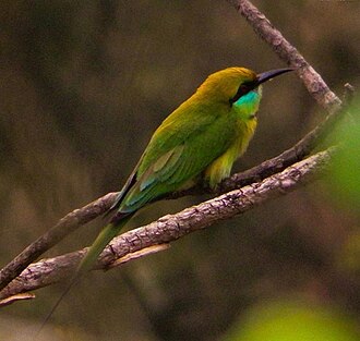 A Green Bee-Eater found in the Kalenjimale
 -
 Northern Golden Orb Weaver Nephila pilipes found in Kalenjimale


Kalenjimale[edit | edit source]
Adjacent to the town, there is a coastal moist forest known as Kalenjimale. This forest has prominence in ancient Hindu mythology. The forest stretches from Ukkuda to Anekallu, covered in the dense canopy and few flatlands in the center & top. There are roads leading into the heart of the forest used by the forest officials, but these roads not accessible as it used rarely. The river flows beside the forest, thus keeping the nutrient cycle going. The forest is accessible with various roads connecting towns nearby. Since the forest status is reserved and protected under law, this pristine wilderness is still intact. Even though the trees are cut down and replaced by Earleaf Acacia, Acacia auriculiformis, lot of work is being done on reversing the damage done to this ecosystem. The diverse bird activities during the seasons attract photographers and nature enthusiasts.
Climate[edit | edit source]
As this place is in between the coast and the Western ghats, this place is known to humid summer and heavy rainfalls, the temperature varies from 21 degree Celsius to 33 degrees Celsius. The summer starts from mid of February and lasts until June. Pre-monsoon showers or mango showers are seen from mid-May, and the rainy season usually lasts until September. The area revives an average annual rainfall of 500mm. From November to February is the winter, when temperatures are usually between 21 and 26 degrees Celsius.
| Climate data for Vittla, India | |||||||||||||
|---|---|---|---|---|---|---|---|---|---|---|---|---|---|
| Month | Jan | Feb | Mar | Apr | May | Jun | Jul | Aug | Sep | Oct | Nov | Dec | Year |
| Average high °C (°F) | 31.4 (88.5) |
31.7 (89.1) |
32.5 (90.5) |
33.0 (91.4) |
32.3 (90.1) |
29.4 (84.9) |
28.1 (82.6) |
28.3 (82.9) |
28.9 (84.0) |
30.0 (86.0) |
30.9 (87.6) |
31.4 (88.5) |
30.7 (87.2) |
| Daily mean °C (°F) | 26.3 (79.3) |
27.0 (80.6) |
28.2 (82.8) |
29.3 (84.7) |
28.8 (83.8) |
26.5 (79.7) |
25.6 (78.1) |
25.8 (78.4) |
26.0 (78.8) |
26.7 (80.1) |
26.7 (80.1) |
26.3 (79.3) |
26.9 (80.4) |
| Average low °C (°F) | 21.2 (70.2) |
22.3 (72.1) |
23.9 (75.0) |
25.6 (78.1) |
25.4 (77.7) |
23.7 (74.7) |
23.2 (73.8) |
23.3 (73.9) |
23.2 (73.8) |
23.4 (74.1) |
22.6 (72.7) |
21.3 (70.3) |
21.2 (70.2) |
| Average rainfall mm (inches) | 0 (0) |
1 (0.0) |
5 (0.2) |
55 (2.2) |
209 (8.2) |
951 (37.4) |
1,386 (54.6) |
796 (31.3) |
371 (14.6) |
256 (10.1) |
79 (3.1) |
21 (0.8) |
4,130 (162.5) |
| Source: Climate-Data.org - Climate Table of Vitla, Karnataka, India[4] | |||||||||||||
Kotikere[edit | edit source]
Kotikere is swimming pool, which was built and used by the royal family of Vitla which is now used by the public. Swimming training and competitions are conducted here. The spring water from the quarry and other sources fill the pool and water overflows most of the time, thus the pool is maintained clean naturally.

Education[edit | edit source]
Some of schools and colleges in and around Vitla.

- Govt Model Higher Primary School, Vittal-574243
- Vittal Pre-University College-574243
- Vittal Girls' High School, Vittal-574243
- Vittal Jaycees English Medium School, Basavanagudi, Vitla-574243
- St. Rita English Medium & Aided School Church Road, Vittal-574243
- Horizon Public School Meginapete Vittal-574243
- Sri Sathya Sai Primary School-Vidya Kuteera Alike-574235
- Sri Sathya Sai Loka Seva High School-Bala Kuteera Alike-574235
- Sri Sathya Sai Loka Seva Vidya Kendra Alike-574235
- Sri Sathya Sai Loka Seva PU College-Sathya Sai Vihara Alike-574235
- Govt. Pre-University College Kanyana-574279
- Sri Devi High School Punacha – 574243
- Sri Rama High School Kalladka-574222
- Sri Krishna Vidyodhaya Higher Primary School – Kanathadka
- Govt Arts and Commerce degree college, Vittal-574243
- Ukkuda Public School, Ukkuda, Vitla-574243
Demographics & People of Vitla[edit | edit source]
source: [Census 2011]
- Hindus (63.7%)
- Muslim (31.5%)
- Christians (4.70%)
- Other (0.08%)
According to the 2011 census report, Hindus form the largest religious group in Vittla (11220 that is 63.69% of the town population). The number of Muslims is 5555 (31.53% of the taluk population) and the number of Christians in the taluk is 828 (4.70%) The people of Vitla are known for their hospitality & generosity.[5]
-
 Vitla Shri Panchalingeshwara Temple
 -
 Mohiyuddin Juma Masjid Vitla


Transportation[edit | edit source]
There is a separate KSRTC bus stand and private bus stand. Vittal is directly connected through bus to Manglore, Puttur, Kasargod, Manjeshwar, Uppala, Hosangady, Salethur, B C Road, Kalladka, Kabaka, Kanyana, Mittanadka, Padyana, Perla, Badiadka, Panaje, Odiyoor, Anekal, Mudipu, Thokkotu, Derlakatte, Adyanadka, Saradka, Boluvar and many other small places. It is the biggest town in Bantwal Taluk, next to Kalladka. And MALABAR buses go through the city Vittal towards Kasaragod to Puttur.

Landmarks[edit | edit source]
The institutions of Sri Satya Sai Baba such as SSSLSVK, PU college and Balakuteera are located in Alike, around 7 km from Vittal. There is a KSRTC Rajahamsa bus from Alike to Bangalore via Vittal. Central Plantation Corps Research Institute (CPCRI) Regional Station is located in Vittal-Puttur Road around 3 km from Vittal Bus Stand.
Nearby places[edit | edit source]
- Anvy zac
- Manila
- Mangalore
- Kasaragod
- Uppala
- Puttur
- Bantwal
- Alike
- kukkaje
- Sri Panolibailu kshetra
- Perla
- Badiyadka
- Kanyana
- Padyana
- Anekallu
- Manjeswar
- Sodankoor
- Kepu
References[edit | edit source]
- ↑ "About CPCRI". cpcri.nic.in. Archived from the original on 28 June 2009. Retrieved 18 January 2010.
- ↑ "Vestige of a bygone era". Deccan Herald. 19 August 2011. Retrieved 3 April 2023.
- ↑ "Vitla history". vittlatemple.org. Archived from the original on 26 August 2010. Retrieved 18 January 2010.
- ↑ "Climate Table of Vitla, Karnataka, India". Climate-Data.org. Retrieved 31 January 2015.
- ↑ ?