



Sylvester41C (talk | contribs) small changes |
|||
| Line 1: | Line 1: | ||
{{Short description|International boundary in South Asia}} | |||
{{Use dmy dates|date=September 2020}} | {{Use dmy dates|date=September 2020}} | ||
{{Infobox border | {{Infobox border | ||
| name = | | name = India-Nepal border | ||
| image = File:Map of Nepal.png | | image = File:Map of Nepal.png | ||
| alt = | | alt = | ||
| caption = Map of Nepal, with India to the south | | caption = Map of Nepal, with India to the south | ||
| territory1 = {{IND}} | | territory1 = {{IND}} | ||
| territory2 = {{NEP}} | | territory2 = <br>{{NEP}} | ||
| length = {{convert| | | length = {{convert|1751|km}} | ||
| enclaves | | enclaves | ||
| established = 1815 | | established = 1815 | ||
| establishedreason = [[Treaty of Sugauli]] between [[Nepal]] and [[British Raj]] | | establishedreason = [[Treaty of Sugauli]] between [[Nepal]] and [[British Raj]] | ||
| current = 15 August 1947 | | current = 15 August 1947 | ||
| currentreason = Independence of | | currentreason = Independence of [[India]] from the [[British Raj]] | ||
| disestablished = | | disestablished = | ||
| disestablishedreason = | | disestablishedreason = | ||
| Line 19: | Line 19: | ||
| notes = | | notes = | ||
}} | }} | ||
The '''India–Nepal border''' is an [[Open border|open]] [[international boundary]] running between the countries of [[India]] and [[Nepal]]. The {{convert|1751|km|mi|2|abbr=on}} long border includes the [[Himalayas|Himalayan]] territories as well as [[Indo-Gangetic Plain]] of [[the subcontinent]].<ref>{{cite web |title=Nepal |url=https://www.cia.gov/the-world-factbook/countries/nepal/ |archive-url=https://web.archive.org/web/20210109075733/https://www.cia.gov/the-world-factbook/countries/nepal |url-status=dead |archive-date=9 January 2021 |publisher=CIA World Factbook |access-date=23 September 2020}}</ref> The current [[National boundary delimitation|border was delimited]] after the [[Treaty of Sugauli|Sugauli treaty]] of 1816 between Nepal and the [[British Raj]].{{Citation needed|date=January 2023}} Following [[Indian independence movement|Indian independence]], the prevailing border was recognised as the international border between the [[Kingdom of Nepal]] and the [[Dominion of India]]. | |||
[[File:Shankharacharya,Gate,Birgunj.jpg|thumb|Shankharacharya Gate, [[Birgunj]], is main entry Point of [[Nepal]] from [[north Bihar]], [[India]] (also known as the 'Gateway of Nepal')]] | |||
==Description== | ==Description== | ||
The border starts in the west at the western [[tripoint]] with China near the [[ | The border starts in the west at the western [[tripoint]] with China near the [[Limpiyadhura]]. It then proceeds to the south-west through the [[Himalayas]], the [[Sivalik Hills]] and then the Gangetic plain, initially overland and then utilising the [[Mahakali River]]. Just east of [[Majhola]] it turns to the south-east and proceeds in that direction overland, occasionally utilising various rivers and hill crests. North-west of [[Islampur, Uttar Dinajpur|Islampur]] the border turns to the north-east and proceeds overland to the eastern Chinese tripoint.{{citation needed|date=September 2020}} | ||
==History== | ==History== | ||
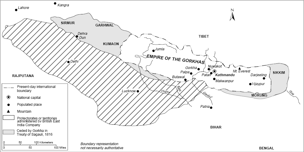
[[File:Sugauli Treaty cessions.png|thumb|right|Areas ceded by Nepal as part of the Treaty of Sugauli]] | [[File:Sugauli Treaty cessions.png|thumb|right|Areas ceded by Nepal as part of the Treaty of Sugauli]] | ||
The border region has historically existed at the edge of various Indian and Nepali kingdoms. It took its modern shape during the period of [[British | The border region has historically existed at the edge of various Indian and Nepali kingdoms. It took its modern shape during the period of [[British India]] which began in the 17th century. While the Gorkhalis fought the [[Kirati people]] to annex their territory in the late 18th century (notably in 1768), the [[Rai people|Gorkha Kingdom]] launched an [[Unification of Nepal|expansion]] drive, bringing them into conflict with the British and resulting in the [[Anglo-Nepalese War]] (1814–16).<ref>{{cite web |title=History of the Nepalese Army |publisher=Nepal Army |url=http://www.nepalarmy.mil.np:80/history.php?page=two |website=nepalarmy.mil.np |access-date=16 January 2019 |archive-url=https://web.archive.org/web/20171228014557/http://www.nepalarmy.mil.np/history.php?page=two |archive-date=28 December 2017 |url-status=dead }}</ref><ref>{{Cite book |url=https://books.google.com/books?id=SZD9--xYamkC |title=Britain and Tibet 1765–1947: A Select Annotated Bibliography of British Relations with Tibet and the Himalayan States Including Nepal, Sikkim and Bhutan |isbn=9780415336475 |last1=Marshall |first1=Julie G. |year=2005|publisher=Psychology Press }}</ref> The [[Kingdom of Nepal]] was defeated and was forced to sign the [[Treaty of Sugauli]] by the [[British East India Company]] (EIC), while ceding large areas of land to [[United Kingdom|Britain]], effectively creating the modern India-Nepal boundary.<ref>{{Cite web|title=Treaty of Sagauli {{!}} British-Nepalese history [1816]|url=https://www.britannica.com/event/Treaty-of-Sagauli|website=Encyclopedia Britannica|language=en|access-date=2020-05-27}}</ref><ref name=Groves>{{cite web |author=Stephen Groves |title=India and Nepal Tackle Border Disputes |newspaper=The Diplomat |date=22 September 2014 |url=https://thediplomat.com/2014/09/india-and-nepal-tackle-border-disputes/ |access-date=2017-03-28 |archive-url=https://web.archive.org/web/20170329050346/https://thediplomat.com/2014/09/india-and-nepal-tackle-border-disputes/ |archive-date=29 March 2017 |url-status=live}}</ref> Finding the [[Terai]] region difficult to manage, the British returned parts of it to Nepal in 1816.<ref name="CS">{{cite web |title=Nepal: A Country Study |url=http://countrystudies.us/nepal/ |publisher=Library of Congress |date=1991| access-date=23 September 2020}}</ref> | ||
India gained independence from the United Kingdom in 1947, and three years later it signed a [[1950 Indo-Nepal Treaty of Peace and Friendship|friendship treaty]] with Nepal, by which both countries agreed to respect the territorial integrity of the other.<ref name="CS"/> Since then relations have largely been cordial, though a number of border disputes remain. There have also been occasional blockades on the border at times of tension, for example in 1987 and [[2015 Nepal blockade|2015]].<ref>{{Cite web |url=http://www.ndtv.com/india-news/nepal-pm-wants-india-to-lift-undeclared-blockade-1243695 |title=Nepal PM Wants India to Lift Undeclared Blockade |access-date=2016-09-12}}</ref><ref name="RIP">{{Cite news |url=https://thediplomat.com/2015/11/r-i-p-indias-influence-in-nepal/ |title=R.I.P., India's Influence in Nepal |last=Arora |first=Vishal |newspaper=The Diplomat |date=November 2015}}</ref> | |||
India | Communities living in India and Nepal close to the Indo-Nepal border have usually shared old, customary ties of kinship and resource access with communities across the border, such as along the western part of the Indo-Nepal border, in the Mahakali valley.<ref>{{Cite journal |last1=Pandey |first1=Abhimanyu |last2=Pradhan |first2=Nawraj |last3=Chaudhari |first3=Swapnil |last4=Ghate |first4=Rucha |date=2017-01-02 |title=Withering of traditional institutions? An institutional analysis of the decline of migratory pastoralism in the rangelands of the Kailash Sacred Landscape, western Himalayas |journal=Environmental Sociology |volume=3 |issue=1 |pages=87–100 |doi=10.1080/23251042.2016.1272179|doi-access=free }}</ref><ref>{{Cite news |last=Pandey |first=Abhimanyu |date=July 22, 2025 |title=Mahakali border tribes a role model for India-Nepal respect |url=https://www.tribuneindia.com/news/premium/mahakali-border-tribes-a-role-model-for-india-nepal-respect/ |work=The Tribune |pages=Opinion}}</ref> | ||
==Border disputes== | ==Border disputes== | ||
{{anchor|Dispute}} | |||
{{Main|Kalapani territory|Susta territory}} | {{Main|Kalapani territory|Susta territory}} | ||
There are two existing territorial disputes between India and Nepal, over the [[Kalapani territory]], a {{convert|35|km2}} area at the India–Nepal–China trijunction in | There are two existing territorial disputes between India and Nepal, over the [[Kalapani territory]], a {{convert|35|km2|adj=on}} area at the India–Nepal–China trijunction in [[Uttarakhand]] State of India, and [[Susta territory|Susta]], a {{convert|20|km2|adj=on}}–{{convert|140|km2|adj=on}} area in Southern Nepal.<ref> | ||
{{citation |first=Alok Kumar |last=Gupta |title=The Context of New-Nepal: Challenges and Opportunities for India |journal=Indian Journal of Asian Affairs |volume=22 |pages=57–73 |number=1/2 |date=June–December 2009 |jstor=41950496 | {{citation |first=Alok Kumar |last=Gupta |title=The Context of New-Nepal: Challenges and Opportunities for India |journal=Indian Journal of Asian Affairs |volume=22 |pages=57–73 |number=1/2 |date=June–December 2009 |jstor=41950496 }}: "Kalapani, 35 square kilometres piece of land, is entangled in controversy since mid-1996, a few months after the ratification of the Mahakali treaty (with India on the harnessing of hydro-power) by Nepal's Parliament." | ||
</ref><ref> | </ref><ref> | ||
{{cite | {{cite news|url=https://economictimes.indiatimes.com/news/politics-and-nation/nepal-objects-to-india-china-trade-pact-via-lipu-lekh-pass/articleshow/47604908.cms|title=Nepal objects to India-China trade pact via Lipu-Lekh Pass|date=9 June 2015|newspaper=The Economic Times}} | ||
</ref><ref> | </ref><ref> | ||
Nidhi Jamwal, [https://scroll.in/article/831576/as-a-river-changed-its-course-a-village-on-the-india-nepal-border-became-disputed-territory As a river changed its course, a village on the India-Nepal border became disputed territory], Scroll.in, 19 March 2017: '"An area of some 5,000 acres [approximately 2,023 hectares] of land in Narsahi-Susta area adjoining the Gandak river in West Champaran district has been encroached upon by Nepalese nationals....," is how the then Union Minister of External Affairs answered a question in the Lok Sabha in 2002. Shrestha, however, alleged that over 14,860 hectares of Nepali land in Susta has been encroached upon by India.' | Nidhi Jamwal, [https://scroll.in/article/831576/as-a-river-changed-its-course-a-village-on-the-india-nepal-border-became-disputed-territory As a river changed its course, a village on the India-Nepal border became disputed territory], Scroll.in, 19 March 2017: '"An area of some 5,000 acres [approximately 2,023 hectares] of land in Narsahi-Susta area adjoining the Gandak river in West Champaran district has been encroached upon by Nepalese nationals....," is how the then Union Minister of External Affairs answered a question in the Lok Sabha in 2002. Shrestha, however, alleged that over 14,860 hectares of Nepali land in Susta has been encroached upon by India.' | ||
</ref> | </ref> | ||
==Border crossings== | |||
</ | ===ICP=== | ||
There are several major border crossings that the Indian [[Borders of India#Integrated Check Posts (ICP)|Integrated Check Posts (ICP)]] use for processing cargo customs and immigration entry for citizens of third countries. These are, from west to east subcategorised by the states of India:<ref name=ndw1>[https://www.newsdrum.in/national/india-bhutan-in-talks-for-establishing-railway-connectivity India Bhutan in talks for establishing connectivity], newsdrum, 7 August 2023.</ref> | |||
* [[Uttarakhand]]: | |||
** [[Banbasa]] in [[Champawat district]] - [[Dodhara Chandani Bridge|Dodhara Chandani]] in [[Kanchanpur District]], [[Sudurpashchim Province]], Nepal. ICP established in 2023.<ref name=ndw1/> | |||
** Planned: | |||
*** [[Pithoragarh]]-[[Dasharathchanda]] | |||
* [[Uttar Pradesh]]: | |||
** [[Rupaidiha]] in [[Bahraich district]] - [[Nepalganj]] in [[Banke District]], Nepal. ICP established in 2022.<ref name=ndw1/> | |||
** [[Sonauli]] in [[Maharajganj district]] - [[Siddharthanagar|Belahia, Siddharthanagar]] in [[Rupandehi District]], Nepal. ICP established in 2023.<ref name=ndw1/> | |||
* [[Bihar]]: | |||
[[File:Icp birgunj.jpg|thumb|ICP [[Birgunj]], [[Nepal]]]] | |||
** [[Raxaul]] in [[East Champaran district]] - [[Birgunj]], Nepal (also known as the 'Gateway of Nepal'). [[ICP Raxaul]] was established in 2018.<ref name=ndw1/> | |||
** [[Bhitthamore]] in [[Sitamarhi district]] - Malibara, [[Jaleshwar]] in Mahottari District, Nepal.<ref>{{Cite web |title=Bhithamore Land Port {{!}} Land Ports Authority of India |url=https://lpai.gov.in/en/icp-bhithamore |access-date=2025-07-17 |website=lpai.gov.in}}</ref> | |||
** [[Jogbani]] in [[Araria district]] - [[Biratnagar]], Nepal. ICP established in 2020.<ref name=ndw1/> | |||
** Planned: | |||
*** Bairia-[[Gauriganj, Nepal|Gauriganj]] | |||
*** Salgori-[[Kechna]] | |||
* [[West Bengal]] | |||
** [[Panitanki]] in [[Darjeeling district]] - [[Kakarbhitta]], Nepal. | |||
** Planned: | |||
*** [[Panitanki]] ([[Naxalbari]])-[[Birtamode]] | |||
** [[Sukhia Pokhri]]-[[Pashupatinagar, Ilam|Pashupatinagar]] | |||
** Planned: | |||
*** [[Pelling]] (Dentam) - Panchami (Oyan) | |||
== | ===Customs crossings=== | ||
Since there are no fences along the border there are several smaller official and unofficial border crossings. Smaller official border crossings | Since there are no fences along the border, there are several smaller official and unofficial border crossings. Smaller official border crossings, known as Chhoti Bhansar (Minor Customs) in the [[Nepali language]], are as follows from west to east (by Indian state): | ||
'''Uttarakhand''' | '''Uttarakhand''' | ||
* [[Jhulaghat]] in [[Pithoragarh district]] - [[Mahakali]] in [[Baitadi District]], Nepal | * [[Jhulaghat]] in [[Pithoragarh district]] - [[Mahakali]] in [[Baitadi District]], Nepal | ||
[[File:Nepal India Border gate Sonauli.jpg|thumb|right|Border gate at Sonauli]] | [[File:Nepal India Border gate Sonauli.jpg|thumb|right|Border gate at Sonauli.]] | ||
'''Uttar Pradesh''' | '''Uttar Pradesh''' | ||
* [[Gauriphanta]] in [[Lakhimpur Kheri district]] - [[Dhangadi]], Nepal | * [[Gauriphanta]] in [[Lakhimpur Kheri district]] - [[Dhangadi]], Nepal. | ||
* Murtiha<!-- Retain redlink to encourage creation of article--> in Lakhimpur Kheri district - [[Gulariya]], Bardiya, Nepal | * Murtiha<!-- Retain redlink to encourage creation of article--> in Lakhimpur Kheri district - [[Gulariya]], Bardiya, Nepal. | ||
* Tal Baghaura<!-- Retain redlink to encourage creation of article--> in [[Shravasti district]] - [[Laxmanpur]], Nepal | * Tal Baghaura<!-- Retain redlink to encourage creation of article--> in [[Shravasti district]] - [[Laxmanpur]], Nepal. | ||
* [[Tulsipur]] in [[Balrampur district]] - [[Koilabas]], Nepal | * [[Tulsipur]] in [[Balrampur district, Uttar Pradesh|Balrampur district]] - [[Koilabas]], Nepal. | ||
* [[Barhani Bazar]] in [[Siddharthnagar district]] - [[Krishnanagar, Nepal|Krishnanagar]], Nepal | * [[Barhani Bazar]] in [[Siddharthnagar district]] - [[Krishnanagar, Nepal|Krishnanagar]], Nepal | ||
'''Bihar''' | '''Bihar''' | ||
* [[Bhikhna Thori railway station|Bhikhna Thori]] in [[West Champaran district]] - [[Thori]] in [[Parsa District]], Nepal | [[File:Birgunj_Customs.jpg|thumb|right|Vehicles Entry and Permit Customs Office in Birgunj Nepal, Border of Bihar, India]] | ||
* | [[File:indiancustoms2.jpg|thumb|right|Border gate at Bhitthamore.]] | ||
* [[ | |||
* | *[[Bhitthamore]] in [[Sitamarhi district]], Bihar - [[Jaleshwar|Jaleshwor]] in [[Mahottari District]], Nepal. | ||
* | * Valmiki Nagar ([[Bhikhna Thori railway station|Bhikhna Thori]]) in [[West Champaran district]] - [[Thori]] in [[Parsa District]], Nepal.<ref name=custc1/> | ||
* [[ | * [[Bairgania]] in [[Sitamarhi district]] - [[Gaur, Nepal|Gaur]] in [[Rautahat District]], Nepal.<ref name=custc1/> | ||
* [[ | * [[Sonbarsha, Sitamarhi (Vidhan Sabha constituency)|Sonbarsa]] in [[Sitamarhi district]] - [[Malangwa]] in Sarlahi District, Nepal. | ||
* | * [[Pipraun]]<!-- Retain redlink to encourage creation of article--> in [[Madhubani district]] - Jatahi-[[Nagarain]] in [[Dhanusa District]], Nepal. | ||
* | *[[Jainagar, Bihar|Jainagar]] in [[Madhubani district]] - [[Inarwa Phulbariya]] in [[Saptari District]], Nepal.<ref name=custc1/> | ||
*[[Laukaha]] in [[Madhubani district]] - [[Thadi]] in [[Bhagwanpur, Siraha|Bhagwanpur]] near [[Lahan]] Mulcipality in [[Siraha District]] of [[Nepal]].<ref>{{Cite web|url=http://www.eximguru.com/exim/trade-agreement/india-nepal-trade.aspx|title=India Nepal Trade Agreement. India-Nepal Foreign Treaty of Trade Agreement.|website=www.eximguru.com|access-date=2019-09-12}}</ref><ref>{{Cite web|url=https://www.customs.gov.np/en/customsofficescontact.html|title=Department of Customs, Nepal - Custom Contact Offices|website=www.customs.gov.np|access-date=2019-09-12|archive-date=25 September 2019|archive-url=https://web.archive.org/web/20190925112809/https://www.customs.gov.np/en/customsofficescontact.html|url-status=dead}}</ref> | |||
*[[Gandhi Chowk, Madhwapur]] in Madhubani district, India - [[Matihani, Mahottari|Matihani]] in Mahottari district, Nepal | |||
* Kunaolee (in [[Bhimnagar, Supaul|Bhimnagar]]) in [[Supaul district]] - Bhantabari<!-- Retain redlink to encourage creation of article-->-[[Haripur, Sunsari|Haripur]] in [[Sunsari District]], Nepal (via Kosi barrage).<ref name=custc1>[https://www.outlookindia.com/national/10-land-customs-stations-to-come-up-in-bihar-along-indo-nepal-border-shah-news-318557/amp 10 Land Customs Stations To Come Up In Bihar Along Indo-Nepal Border: Shah.], outlookindia, 16 sept 2023.</ref> | |||
* Amgachhi<!-- Retain redlink to encourage creation of article--> in [[Araria district]] - [[Rangeli]] in [[Morang District]], Nepal. | |||
* Bahadurganj (Baria)<!-- Retain redlink to encourage creation of article--> (Bairia bazar) in [[Kishanganj district]] - [[Gauriganj, Nepal|Gauriganj]] in [[Jhapa District]], Nepal. | |||
* Galgalia (Kishanganj district).<ref name=custc1/> | |||
'''West Bengal''' | '''West Bengal''' | ||
* [[Mirik]] in [[Darjeeling district]] - [[Pashupatinagar, Ilam]], Nepal | * [[Mirik]] in [[Darjeeling district]] - [[Pashupatinagar, Ilam]], Nepal | ||
==Cross-border railway lines== | |||
{{anchor | Rail }} | |||
{{see also|Nepal Railway Company Limited|l1=Railway in Nepal|China–Nepal railway}} | |||
8 railway lines between India and Nepal either exist or they are under construction or planning as follows (listed east to west):<ref name=irn1>[https://economictimes.indiatimes.com/news/politics-and-nation/how-poor-rail-connectivity-is-acting-as-a-hindrance-to-indias-act-east-policy/articleshow/71665523.cms How poor rail connectivity is acting as a hindrance to India's Act East policy], Economic Times, 20 October 2020.</ref> | |||
# Babaganj-Nepalganj line - complete and operational:<ref name=irn1/> | |||
# Barhani-Kathmandu line - under planning:<ref name=irn1/> | |||
# Barhani-Kapilvastu line - under planning:<ref name=irn1/> | |||
# Nautanwa-Bhairwa line - under planning:<ref name=irn1/> | |||
# Raxaul-Kathmandu line - under planning:<ref name=irn1/> | |||
# [[Jaynagar-Bardibas railway line]] - mostly complete, except final and third phase (as of April 2022):<ref name=irn1/> 52 km out of total 68 km complete as of April 2022 while remaining is awaiting land acquisition.<ref name=ngr1>{{cite web |url=https://timesofindia.indiatimes.com/india/india-nepal-railway-service-the-projects-route-cost-in-10-points/articleshow/90585302.cms |title=India- Nepal railway service: The projects, route, cost in 10 points |date=1 April 2022 |work=The Times of India |access-date=5 April 2022}}</ref><ref>{{cite web |url=https://www.dailypioneer.com/2022/state-editions/train-services-to-restart-on-jayanagar-janakpur-dham-kurtha-section.html |title=Train services to restart on Jayanagar-Janakpur Dham-Kurtha section |date=1 April 2022 |website= |publisher=The Pioneer |access-date=5 April 2022}}</ref> | |||
# [[Nepal Railway Company Limited#bbl|Jogbani-Biratnagar railway line]] - mostly complete, except 8 km long under construction section (as of April 2022):<ref name=irn1/> total 18.6 km.<ref>{{cite web |url=https://www.aninews.in/news/world/asia/jaynagar-kurtha-railway-brings-modernization-in-nepals-railway-connection-says-nepal-minister20211022222905/?amp=1 |title=Jaynagar-Kurtha Railway brings modernization in Nepal's railway connection, says Nepal Minister |date=22 October 2021 |website= |publisher=ANI |access-date=5 April 2022}}</ref><ref>{{cite web |url=https://www.metrorailnews.in/ircon-invites-tender-for-civil-works-at-biratnagar-station-on-jogbani-india-to-biratnagar-nepal-railway-line/?amp |title=IRCON invites tender for civil works at Biratnagar Station on Jogbani (India) to Biratnagar (Nepal) Railway Line |date=9 April 2021 |website= |publisher=Metro Rail News |access-date=5 April 2022}}</ref><ref>{{cite web |url=https://kathmandupost.com/money/2021/09/27/construction-work-resumes-on-katahari-bathnaha-railway-line |title=Construction work resumes on Katahari-Bathnaha railway line |date=27 September 2021 |website= |publisher=The Kathmandu Post |access-date=5 April 2022}}</ref> | |||
# Kakarbhitta-New Jalpaiguri railway line - under planning:<ref name=irn1/> | |||
==Border security== | ==Border security== | ||
{{see also|Borders_of_India#Border_barriers|l1=India's border barriers with neighbouring countries}} | |||
The | The Nepal–India border is an [[open border]],<ref name="borff1">[https://sundayguardianlive.com/opinion/india-urgently-needs-a-national-border-policy], Sunday Guardian, 11 Feb 2024</ref> which is relatively peaceful. Nepali and Indian nationals do not need passports or visas to enter each other's countries, and tens of thousands of people cross the border every day for tourism and commerce. | ||
On a local level, Indian and Nepali district officials meet regularly to discuss security challenges and other issues on their respective border portions. Such meetings are usually attended by District Magistrates, local SSB representatives, customs chiefs from India including the Chief District Officer (CDO), local APF, Police and custom chiefs from Nepal.<ref>{{cite web|url=https://thehimalayantimes.com/nepal/nepal-india-border-security-meeting-concludes/|title=Nepal-India border security meeting concludes|date=16 Oct 2018|publisher=The Himalayan Times}}</ref> | The Indian side of the border is regulated by [[Sashastra Seema Bal|Sashastra Seema Bal (SSB)]] along with local police. The Nepali side of the border is regulated by the [[Armed Police Force (Nepal)|Armed Police Force (APF)]] along with the local branch of [[Nepal Police]]. Often SSB (India) and APF (Nepal) perform joint patrols on the border.<ref>{{cite web|url=https://thehimalayantimes.com/nepal/armed-police-force-ssb-start-joint-patrolling-on-no-mans-land/|title=Armed Police Force, SSB start joint patrolling on no man's land|date=7 Jan 2019|publisher=The Himalayan Times}}</ref> On a local level, Indian and Nepali district officials meet regularly to discuss security challenges and other issues on their respective border portions. Such meetings are usually attended by District Magistrates, local SSB representatives, customs chiefs from India including the Chief District Officer (CDO), local APF, Police and custom chiefs from Nepal.<ref>{{cite web|url=https://thehimalayantimes.com/nepal/nepal-india-border-security-meeting-concludes/|title=Nepal-India border security meeting concludes|date=16 Oct 2018|publisher=The Himalayan Times}}</ref> | ||
== See also == | == See also == | ||
* [[India–Nepal relations]] | * [[India–Nepal relations]] | ||
* [[Indo-Nepal Border Road]] | |||
== References == | == References == | ||
{{reflist}} | {{reflist}} | ||
{{Borders of India}} | {{Borders of India}} | ||
{{Borders of Nepal}} | {{Borders of Nepal}} | ||
Latest revision as of 05:01, 29 March 2026
Template:Infobox border The India–Nepal border is an open international boundary running between the countries of India and Nepal. The 1,751 km (1,088.02 mi) long border includes the Himalayan territories as well as Indo-Gangetic Plain of the subcontinent.[1] The current border was delimited after the Sugauli treaty of 1816 between Nepal and the British Raj.[citation needed] Following Indian independence, the prevailing border was recognised as the international border between the Kingdom of Nepal and the Dominion of India.

Description[edit | edit source]
The border starts in the west at the western tripoint with China near the Limpiyadhura. It then proceeds to the south-west through the Himalayas, the Sivalik Hills and then the Gangetic plain, initially overland and then utilising the Mahakali River. Just east of Majhola it turns to the south-east and proceeds in that direction overland, occasionally utilising various rivers and hill crests. North-west of Islampur the border turns to the north-east and proceeds overland to the eastern Chinese tripoint.[citation needed]
History[edit | edit source]

The border region has historically existed at the edge of various Indian and Nepali kingdoms. It took its modern shape during the period of British India which began in the 17th century. While the Gorkhalis fought the Kirati people to annex their territory in the late 18th century (notably in 1768), the Gorkha Kingdom launched an expansion drive, bringing them into conflict with the British and resulting in the Anglo-Nepalese War (1814–16).[2][3] The Kingdom of Nepal was defeated and was forced to sign the Treaty of Sugauli by the British East India Company (EIC), while ceding large areas of land to Britain, effectively creating the modern India-Nepal boundary.[4][5] Finding the Terai region difficult to manage, the British returned parts of it to Nepal in 1816.[6]
India gained independence from the United Kingdom in 1947, and three years later it signed a friendship treaty with Nepal, by which both countries agreed to respect the territorial integrity of the other.[6] Since then relations have largely been cordial, though a number of border disputes remain. There have also been occasional blockades on the border at times of tension, for example in 1987 and 2015.[7][8]
Communities living in India and Nepal close to the Indo-Nepal border have usually shared old, customary ties of kinship and resource access with communities across the border, such as along the western part of the Indo-Nepal border, in the Mahakali valley.[9][10]
Border disputes[edit | edit source]
There are two existing territorial disputes between India and Nepal, over the Kalapani territory, a 35-square-kilometre (14 sq mi) area at the India–Nepal–China trijunction in Uttarakhand State of India, and Susta, a 20-square-kilometre (7.7 sq mi)–140-square-kilometre (54 sq mi) area in Southern Nepal.[11][12][13]
Border crossings[edit | edit source]
ICP[edit | edit source]
There are several major border crossings that the Indian Integrated Check Posts (ICP) use for processing cargo customs and immigration entry for citizens of third countries. These are, from west to east subcategorised by the states of India:[14]
- Uttarakhand:
- Banbasa in Champawat district - Dodhara Chandani in Kanchanpur District, Sudurpashchim Province, Nepal. ICP established in 2023.[14]
- Planned:
- Uttar Pradesh:
- Rupaidiha in Bahraich district - Nepalganj in Banke District, Nepal. ICP established in 2022.[14]
- Sonauli in Maharajganj district - Belahia, Siddharthanagar in Rupandehi District, Nepal. ICP established in 2023.[14]
- Bihar:

- Raxaul in East Champaran district - Birgunj, Nepal (also known as the 'Gateway of Nepal'). ICP Raxaul was established in 2018.[14]
- Bhitthamore in Sitamarhi district - Malibara, Jaleshwar in Mahottari District, Nepal.[15]
- Jogbani in Araria district - Biratnagar, Nepal. ICP established in 2020.[14]
- Planned:
- West Bengal
- Panitanki in Darjeeling district - Kakarbhitta, Nepal.
- Planned:
- Sukhia Pokhri-Pashupatinagar
- Planned:
- Pelling (Dentam) - Panchami (Oyan)
Customs crossings[edit | edit source]
Since there are no fences along the border, there are several smaller official and unofficial border crossings. Smaller official border crossings, known as Chhoti Bhansar (Minor Customs) in the Nepali language, are as follows from west to east (by Indian state):
Uttarakhand
- Jhulaghat in Pithoragarh district - Mahakali in Baitadi District, Nepal

Uttar Pradesh
- Gauriphanta in Lakhimpur Kheri district - Dhangadi, Nepal.
- Murtiha in Lakhimpur Kheri district - Gulariya, Bardiya, Nepal.
- Tal Baghaura in Shravasti district - Laxmanpur, Nepal.
- Tulsipur in Balrampur district - Koilabas, Nepal.
- Barhani Bazar in Siddharthnagar district - Krishnanagar, Nepal
Bihar


- Bhitthamore in Sitamarhi district, Bihar - Jaleshwor in Mahottari District, Nepal.
- Valmiki Nagar (Bhikhna Thori) in West Champaran district - Thori in Parsa District, Nepal.[16]
- Bairgania in Sitamarhi district - Gaur in Rautahat District, Nepal.[16]
- Sonbarsa in Sitamarhi district - Malangwa in Sarlahi District, Nepal.
- Pipraun in Madhubani district - Jatahi-Nagarain in Dhanusa District, Nepal.
- Jainagar in Madhubani district - Inarwa Phulbariya in Saptari District, Nepal.[16]
- Laukaha in Madhubani district - Thadi in Bhagwanpur near Lahan Mulcipality in Siraha District of Nepal.[17][18]
- Gandhi Chowk, Madhwapur in Madhubani district, India - Matihani in Mahottari district, Nepal
- Kunaolee (in Bhimnagar) in Supaul district - Bhantabari-Haripur in Sunsari District, Nepal (via Kosi barrage).[16]
- Amgachhi in Araria district - Rangeli in Morang District, Nepal.
- Bahadurganj (Baria) (Bairia bazar) in Kishanganj district - Gauriganj in Jhapa District, Nepal.
- Galgalia (Kishanganj district).[16]
West Bengal
- Mirik in Darjeeling district - Pashupatinagar, Ilam, Nepal
Cross-border railway lines[edit | edit source]
8 railway lines between India and Nepal either exist or they are under construction or planning as follows (listed east to west):[19]
- Babaganj-Nepalganj line - complete and operational:[19]
- Barhani-Kathmandu line - under planning:[19]
- Barhani-Kapilvastu line - under planning:[19]
- Nautanwa-Bhairwa line - under planning:[19]
- Raxaul-Kathmandu line - under planning:[19]
- Jaynagar-Bardibas railway line - mostly complete, except final and third phase (as of April 2022):[19] 52 km out of total 68 km complete as of April 2022 while remaining is awaiting land acquisition.[20][21]
- Jogbani-Biratnagar railway line - mostly complete, except 8 km long under construction section (as of April 2022):[19] total 18.6 km.[22][23][24]
- Kakarbhitta-New Jalpaiguri railway line - under planning:[19]
Border security[edit | edit source]
The Nepal–India border is an open border,[25] which is relatively peaceful. Nepali and Indian nationals do not need passports or visas to enter each other's countries, and tens of thousands of people cross the border every day for tourism and commerce.
The Indian side of the border is regulated by Sashastra Seema Bal (SSB) along with local police. The Nepali side of the border is regulated by the Armed Police Force (APF) along with the local branch of Nepal Police. Often SSB (India) and APF (Nepal) perform joint patrols on the border.[26] On a local level, Indian and Nepali district officials meet regularly to discuss security challenges and other issues on their respective border portions. Such meetings are usually attended by District Magistrates, local SSB representatives, customs chiefs from India including the Chief District Officer (CDO), local APF, Police and custom chiefs from Nepal.[27]
See also[edit | edit source]
References[edit | edit source]
- ↑ "Nepal". CIA World Factbook. Archived from the original on 9 January 2021. Retrieved 23 September 2020.
- ↑ "History of the Nepalese Army". nepalarmy.mil.np. Nepal Army. Archived from the original on 28 December 2017. Retrieved 16 January 2019.
- ↑ Marshall, Julie G. (2005). Britain and Tibet 1765–1947: A Select Annotated Bibliography of British Relations with Tibet and the Himalayan States Including Nepal, Sikkim and Bhutan. Psychology Press. ISBN 9780415336475.
- ↑ "Treaty of Sagauli | British-Nepalese history [1816]". Encyclopedia Britannica. Retrieved 27 May 2020.
- ↑ Stephen Groves (22 September 2014). "India and Nepal Tackle Border Disputes". The Diplomat. Archived from the original on 29 March 2017. Retrieved 28 March 2017.
- ↑ 6.0 6.1 "Nepal: A Country Study". Library of Congress. 1991. Retrieved 23 September 2020.
- ↑ "Nepal PM Wants India to Lift Undeclared Blockade". Retrieved 12 September 2016.
- ↑ Arora, Vishal (November 2015). "R.I.P., India's Influence in Nepal". The Diplomat.
- ↑ Pandey, Abhimanyu; Pradhan, Nawraj; Chaudhari, Swapnil; Ghate, Rucha (2 January 2017). "Withering of traditional institutions? An institutional analysis of the decline of migratory pastoralism in the rangelands of the Kailash Sacred Landscape, western Himalayas". Environmental Sociology. 3 (1): 87–100. doi:10.1080/23251042.2016.1272179.
- ↑ Pandey, Abhimanyu (22 July 2025). "Mahakali border tribes a role model for India-Nepal respect". The Tribune. pp. Opinion.
- ↑ Gupta, Alok Kumar (June–December 2009), "The Context of New-Nepal: Challenges and Opportunities for India", Indian Journal of Asian Affairs, 22 (1/2): 57–73, JSTOR 41950496: "Kalapani, 35 square kilometres piece of land, is entangled in controversy since mid-1996, a few months after the ratification of the Mahakali treaty (with India on the harnessing of hydro-power) by Nepal's Parliament."
- ↑ "Nepal objects to India-China trade pact via Lipu-Lekh Pass". The Economic Times. 9 June 2015.
- ↑ Nidhi Jamwal, As a river changed its course, a village on the India-Nepal border became disputed territory, Scroll.in, 19 March 2017: '"An area of some 5,000 acres [approximately 2,023 hectares] of land in Narsahi-Susta area adjoining the Gandak river in West Champaran district has been encroached upon by Nepalese nationals....," is how the then Union Minister of External Affairs answered a question in the Lok Sabha in 2002. Shrestha, however, alleged that over 14,860 hectares of Nepali land in Susta has been encroached upon by India.'
- ↑ 14.0 14.1 14.2 14.3 14.4 14.5 India Bhutan in talks for establishing connectivity, newsdrum, 7 August 2023.
- ↑ "Bhithamore Land Port | Land Ports Authority of India". lpai.gov.in. Retrieved 17 July 2025.
- ↑ 16.0 16.1 16.2 16.3 16.4 10 Land Customs Stations To Come Up In Bihar Along Indo-Nepal Border: Shah., outlookindia, 16 sept 2023.
- ↑ "India Nepal Trade Agreement. India-Nepal Foreign Treaty of Trade Agreement". www.eximguru.com. Retrieved 12 September 2019.
- ↑ "Department of Customs, Nepal - Custom Contact Offices". www.customs.gov.np. Archived from the original on 25 September 2019. Retrieved 12 September 2019.
- ↑ 19.0 19.1 19.2 19.3 19.4 19.5 19.6 19.7 19.8 How poor rail connectivity is acting as a hindrance to India's Act East policy, Economic Times, 20 October 2020.
- ↑ "India- Nepal railway service: The projects, route, cost in 10 points". The Times of India. 1 April 2022. Retrieved 5 April 2022.
- ↑ "Train services to restart on Jayanagar-Janakpur Dham-Kurtha section". The Pioneer. 1 April 2022. Retrieved 5 April 2022.
- ↑ "Jaynagar-Kurtha Railway brings modernization in Nepal's railway connection, says Nepal Minister". ANI. 22 October 2021. Retrieved 5 April 2022.
- ↑ "IRCON invites tender for civil works at Biratnagar Station on Jogbani (India) to Biratnagar (Nepal) Railway Line". Metro Rail News. 9 April 2021. Retrieved 5 April 2022.
- ↑ "Construction work resumes on Katahari-Bathnaha railway line". The Kathmandu Post. 27 September 2021. Retrieved 5 April 2022.
- ↑ [1], Sunday Guardian, 11 Feb 2024
- ↑ "Armed Police Force, SSB start joint patrolling on no man's land". The Himalayan Times. 7 January 2019.
- ↑ "Nepal-India border security meeting concludes". The Himalayan Times. 16 October 2018.