

imported>BD2412 m →Demographics: Typo fixing for Wikipedia:Typo Team/moss, replaced: ,T → , T, ,t → , t, inline, title → inline,title |
m quick enhance article as per guidelines additionally for consistency |
||
| Line 2: | Line 2: | ||
{{Use Indian English|date=February 2017}} | {{Use Indian English|date=February 2017}} | ||
{{Infobox settlement | {{Infobox settlement | ||
| name | | name = South Canara | ||
| settlement_type = [[Administrative divisions of Madras Presidency|District of Madras Presidency]] | |||
| image_caption = South Canara | |||
| image_map = | |||
| coordinates = {{coord|13.00|N|75.40|E|display=inline,title}} | |||
| settlement_type | | subdivision_type = Country | ||
| subdivision_name = {{flag|British Raj}} | |||
| subdivision_type1 = [[Presidencies and provinces of British India|Presidency]] | |||
| image_caption | | subdivision_name1 = [[Madras Presidency|Madras]] | ||
| image_map | | subdivision_type2 = Metro | ||
| subdivision_name2 = <!-- for neighbourhoods/suburbs only --> | |||
| established_title = <!-- Established --> | |||
| coordinates | | seat_type = Headquarters | ||
| subdivision_type | | seat = <!-- for districts only --> | ||
| subdivision_name | | unit_pref = Metric | ||
| subdivision_type1 | | area_total_km2 = 8441 | ||
| subdivision_name1 | | population_total = 3,005,897 | ||
| subdivision_type2 | | population_as_of = 2001 | ||
| subdivision_name2 | | population_density_km2 = 356.1 | ||
| established_title | | population_footnotes = <ref name="poptn">{{Cite web|url=http://www.censusindiamaps.net/page/India_WhizMap/IndiaMap.htm |title=Census GIS India |publisher=Census of India |access-date=2008-03-26}}</ref> | ||
| demographics_type1 = Languages | |||
| demographics1_title1 = Administrative | |||
| demographics1_info1 = [[English language|English]], [[Tamil language|Tamil]], [[Hindustani language|Hindustani]] | |||
| seat_type | | demographics1_title2 = Spoken languages | ||
| seat | | demographics1_info2 = [[Tulu language|Tulu]], [[Konkani language|Konkani]], [[Kannada language|Kannada]], [[Malayalam language|Malayalam]], [[Marathi language|Marathi]], [[Hindustani language|Hindustani]], [[Beary bashe|Beary]], [[Arebhashe dialect|Arebashe]] | ||
| | | timezone1 = [[Indian Standard Time|IST]] | ||
| utc_offset1 = +5:30 | |||
| postal_code_type = <!-- [[Postal Index Number|PIN]] --> | |||
| iso_code = [[ISO 3166-2:IN]] | |||
| registration_plate = KA-19, KA-20, KA-21, KA-62, KL-14 | |||
| area_total_km2 | | blank1_name_sec1 = Largest city | ||
| blank1_info_sec1 = [[Mangalore]] | |||
| blank2_name_sec1 = [[IUCN protected area categories|IUCN category]] | |||
| population_total | | blank2_info_sec1 = <!-- for protected areas only --> | ||
| population_as_of | |||
| population_density_km2 | |||
| population_footnotes | |||
| demographics_type1 | |||
| demographics1_title1 | |||
| demographics1_info1 | |||
| demographics1_title2 | |||
| demographics1_info2 | |||
| timezone1 | |||
| utc_offset1 | |||
| postal_code_type | |||
| iso_code | |||
| registration_plate | |||
| blank1_name_sec1 | |||
| blank1_info_sec1 | |||
| blank2_name_sec1 | |||
| blank2_info_sec1 | |||
}} | }} | ||
'''South Canara''' was a district of the [[Madras Presidency]] of [[British | '''South Canara''' (South Kannada) was a district of the [[Madras Presidency]] of [[British Raj]], located at {{Coord|13.00|N|75.40|E|region:IN_type:adm2nd}}.<ref>Patsy Lozupone, Bruce M. Beehler, Sidney Dillon Ripley.(2004).[https://books.google.com/books?id=-jdHAAAAYAAJ&q=South+Kanara+ ''Ornithological gazetteer of the Indian subcontinent'', p. 82].Center for Applied Biodiversity Science, Conservation International. {{ISBN|1-881173-85-2}}.</ref> It comprised the towns of [[Kasaragod]] and [[Udupi]] and adjacent villages, with the administration at [[Mangalore city]]. South Canara was one of the most heterogeneous areas of [[Madras Presidency]], with [[Tulu language|Tulu]], [[Malayalam]], [[Kannada]], [[Konkani language|Konkani]], [[Marathi language|Marathi]], [[Hindustani language|Hindustani]], and [[Beary bashe|Beary]] languages being spoken while [[English language|English]], [[Tamil language|Tamil]] and Hindustani remained the official languages. It was succeeded by the [[Tulu language|Tulu]]-speaking areas of [[Dakshina Kannada]] district,<ref>{{cite book | ||
| author = K. Balasubramanyam | year=1965 | | author = K. Balasubramanyam | year=1965 | ||
| title= 1961 Census Handbook- South Kanara District | publisher=Directorate of Census Operations, Mysore | | title= 1961 Census Handbook- South Kanara District | publisher=Directorate of Census Operations, Mysore | ||
| url= http://lsi.gov.in:8081/jspui/bitstream/123456789/6118/1/22745_1961_SOU.pdf | | url= http://lsi.gov.in:8081/jspui/bitstream/123456789/6118/1/22745_1961_SOU.pdf | ||
}}</ref> | }}</ref> the [[Malayalam]]-speaking area of [[Kasaragod district]]<ref>{{cite book | ||
| author = M. K. Devassy | year=1965 | | author = M. K. Devassy | year=1965 | ||
| title= 1961 Census Handbook- Cannanore District | publisher=Directorate of Census Operations, Kerala and The Union Territory of Laccadive, Minicoy, and Amindivi Islands | | title= 1961 Census Handbook- Cannanore District | publisher=Directorate of Census Operations, Kerala and The Union Territory of Laccadive, Minicoy, and Amindivi Islands | ||
| url= http://lsi.gov.in:8081/jspui/bitstream/123456789/5668/1/22055_1961_CAN.pdf | | url= http://lsi.gov.in:8081/jspui/bitstream/123456789/5668/1/22055_1961_CAN.pdf | ||
}}</ref> and [[Amindivi]] islands<ref name="clt">{{Cite book|title=District Census Handbook -Laccadive, Minicoy, and Amindivi Islands (1971) - Village Directory|last=P. M. Nair|publisher=Administrator and Ex-Officio Director of Census Operations, Laccadive, Minicoy, and Amindivi Island|year=1979|location=Kavaratti& Government Printing Press, Kozhikode|pages=2|url=http://lsi.gov.in:8081/jspui/bitstream/123456789/7315/1/26141_1971_LAC.pdf}}</ref> in the year 1956.<ref>{{cite book | }}</ref> and the [[Amindivi]] islands sub-division of the [[Laccadives]],<ref name="clt">{{Cite book|title=District Census Handbook -Laccadive, Minicoy, and Amindivi Islands (1971) - Village Directory|last=P. M. Nair|publisher=Administrator and Ex-Officio Director of Census Operations, Laccadive, Minicoy, and Amindivi Island|year=1979|location=Kavaratti& Government Printing Press, Kozhikode|pages=2|url=http://lsi.gov.in:8081/jspui/bitstream/123456789/7315/1/26141_1971_LAC.pdf}}</ref> in the year 1956.<ref>{{cite book | ||
| author = M. K. Devassy | year=1967 | | author = M. K. Devassy | year=1967 | ||
| title= Census of India - 1961 (Kerala) | publisher=Directorate of Census Operations, Kerala and The Union Territory of Laccadive, Minicoy, and Amindivi Islands | | title= Census of India - 1961 (Kerala) | publisher=Directorate of Census Operations, Kerala and The Union Territory of Laccadive, Minicoy, and Amindivi Islands | ||
| Line 77: | Line 54: | ||
| title= South Kanara, The Nilgiris, Malabar and Coimbatore Districts (Village-wise Mother-tongue Data for Bilingual or Multilingual Taluks) | publisher=Madras Government Press | | title= South Kanara, The Nilgiris, Malabar and Coimbatore Districts (Village-wise Mother-tongue Data for Bilingual or Multilingual Taluks) | publisher=Madras Government Press | ||
| url= http://lsi.gov.in:8081/jspui/bitstream/123456789/6447/1/50056_1951_SOU.pdf | | url= http://lsi.gov.in:8081/jspui/bitstream/123456789/6447/1/50056_1951_SOU.pdf | ||
}}</ref><ref name="census1951"/> | }}</ref><ref name="census1951"/> | ||
==Geography== | ==Geography== | ||
| Line 101: | Line 78: | ||
==History== | ==History== | ||
South Canara was annexed by the [[British East India Company]] following the defeat of [[Tipu Sultan]] in the [[Fourth Anglo-Mysore War|Fourth Mysore War 1799]] and along with [[North Kanara]] formed the district of [[Kanara]] in the Madras Presidency. In 1859, Kanara was split into two districts, North and South. North Kanara was transferred to the [[Bombay Presidency]], and South was retained by Madras. | South Canara was annexed by the [[British East India Company]] following the defeat of [[Tipu Sultan]] in the [[Fourth Anglo-Mysore War|Fourth Mysore War in 1799]] and along with [[North Kanara]] formed the district of [[Kanara]] in the Madras Presidency. In 1859, Kanara was split into two districts, North and South. North Kanara was transferred to the [[Bombay Presidency]], and South was retained by Madras. | ||
== Taluks == | == Taluks == | ||
| Line 139: | Line 116: | ||
|caption = '''Religion in South Canara''' (1951)<ref name="census1951"/> | |caption = '''Religion in South Canara''' (1951)<ref name="census1951"/> | ||
|label1 = [[Hinduism]] | |label1 = [[Hinduism]] | ||
|value1 = | |value1 = 66.58 | ||
|color1 = Orange | |color1 = Orange | ||
|label2 = [[Islam]] | |label2 = [[Islam]] | ||
|value2 = | |value2 = 24.31 | ||
|color2 = Green | |color2 = Green | ||
|label3 = [[Christianity]] | |label3 = [[Christianity]] | ||
| Line 152: | Line 129: | ||
}} | }} | ||
{{Pie chart | {{Pie chart | ||
|thumb = right | | thumb = right | ||
|caption = '''Language in South Canara''' (1951)<ref name="census1951"/> | | caption = '''Language in South Canara''' (1951)<ref name="census1951"/> | ||
|label1 = [[Tulu language|Tulu]] | | label1 = [[Tulu language|Tulu]] | ||
|value1 = 39.94 | | value1 = 39.94 | ||
|color1 = Orange | | color1 = Orange | ||
|label2 = [[Malayalam]] | | label2 = [[Malayalam language|Malayalam]] | ||
|value2 = 24.19 | | value2 = 24.19 | ||
|color2 = Red | | color2 = Red | ||
|label3 = [[Kannada]] | | label3 = [[Kannada]] | ||
|value3 = 17.20 | | value3 = 17.20 | ||
|color3 = Green | | color3 = Green | ||
|label4 = [[Konkani language|Konkani]] | | label4 = [[Konkani language|Konkani]] | ||
|value4 = 13.59 | | value4 = 13.59 | ||
|color4 = DodgerBlue | | color4 = DodgerBlue | ||
|label5 = [[Languages of India|Other]] | | label5 = [[Languages of India|Other]] | ||
|value5 = 5.08 | | value5 = 5.08 | ||
|color5 = Black | | color5 = Black | ||
}} | }} | ||
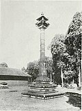
[[File:TempleStambha1913.jpg|thumb|200px|Temple ''stambha'', South Canara]] | [[File:TempleStambha1913.jpg|thumb|200px|Temple ''stambha'', South Canara]] | ||
South Kanara had a total population of 1,748,991 in 1951, of whom | South Kanara had a total population of 1,748,991 in 1951, of whom 66.58% were Hindu, 24.31% Muslim and 8.85% Christian.<ref name="census1951"/> The most widely spoken language was Tulu, which was the mother tongue of 40% of the population, followed by Malayalam for 24%, Kannada for 17%, and 13% for [[Konkani language|Konkani]]. In 1901, South Kanara had a density of {{convert|282|PD/sqmi|order=flip}}. | ||
The 1908 ''[[Imperial Gazetteer of India]]'' lists South Canara, along with the [[Thanjavur District|Thanjavur]] and [[Ganjam district|Ganjam]] districts, as the three districts of the [[Madras Presidency]] where [[Brahmins]] | The 1908 ''[[Imperial Gazetteer of India]]'' lists South Canara, along with the [[Thanjavur District|Thanjavur]] and [[Ganjam district|Ganjam]] districts, as the three districts of the [[Madras Presidency]] where [[Brahmins]], one of the four main castes in Hinduism, were most numerous.<ref name="Imperial1908">{{cite book|title=[[The Imperial Gazetteer of India]]|volume=14|year=1908|publisher=[[Clarendon Press]]}}</ref> | ||
The majority of the people were [[Billava]]s and [[Bunt (community)|Bunt]]s. There were more [[Brahmins]] (12% of the population) in South Kanara than any other district of the Madras Presidency making South Kanara, along with [[Tanjore District (Madras Presidency)|Tanjore]] and Ganjam as one of the three districts of the province where Brahmins were most numerous.<ref name="Imperial1908"/> | The majority of the people were [[Billava]]s , [[Kulala]] and [[Bunt (community)|Bunt]]s. There were more [[Brahmins]] (12% of the population) in South Kanara than any other district of the Madras Presidency making South Kanara, along with [[Tanjore District (Madras Presidency)|Tanjore]] and Ganjam, as one of the three districts of the province where Brahmins were most numerous.<ref name="Imperial1908"/> | ||
The original [[indigenous people]] of the region are [[Tuluvas]] ([[Bunt (community)|Bunts]], [[ | The original [[indigenous people]] of the region are [[Tuluvas]] ([[Bunt (community)|Bunts]], [[Kulala]]s, [[Billava]]s, [[Mogaveera]]s, Tulu gowda, [[Devadiga]]s, [[Beary]]s, [[Jogi (caste)|Jogi]]s) and [[Malayali]]s in the [[Kasaragod district|Kasaragod Taluk]] ([[Nambudiri]]s, [[Nair]]s, [[Thiyyar history|Thiyyas]], [[Malabar Muslims|Mappila]]s etc). The Brahmins who settled first belonged chiefly to the [[Sthanika Brahmins|Sthanika]] and thus they were called as Tulu Brahmins. Others were [[Shivalli Brahmins|Shivalli]], [[Saraswat Brahmins|Saraswat]], [[Havyaka Brahmin|Havyaka]], Kotaha sub-sections, Mahars, the hill-tribes (''[[Koraga people|Koragas]]'').<ref name="SilvaAndFuchs">{{cite journal|last1=Silva|first1=Severine|last2= Fuchs|first2=Stephan|publisher=[[Nanzan University]]|title=The Marriage Customs of the Christians in South Canara, India|journal=[[Asian Folklore Studies]]|year=1965|number=2|pages=2–3|volume=24|doi=10.2307/1177555 |jstor=1177555 }}</ref> | ||
{| class="wikitable sortable" style="line-height:20px;text-align:center;" | {| class="wikitable sortable" style="line-height:20px;text-align:center;" | ||
| Line 236: | Line 213: | ||
|- | |- | ||
! 10 | ! 10 | ||
| [[ | | [[Arabic]] | ||
| 1,063 | | 1,063 | ||
| '''0.06%''' | | '''0.06%''' | ||
Latest revision as of 17:22, 5 January 2026
South Canara | |
|---|---|
| Coordinates: 13°00′N 75°24′E / 13.00°N 75.40°E | |
| Country |  British Raj British Raj |
| Presidency | Madras |
| Area | |
| • Total | 8,441 km2 (3,259 sq mi) |
| Population (2001)[1] | |
| • Total | 3,005,897 |
| • Density | 356.1/km2 (922/sq mi) |
| Languages | |
| • Administrative | English, Tamil, Hindustani |
| • Spoken languages | Tulu, Konkani, Kannada, Malayalam, Marathi, Hindustani, Beary, Arebashe |
| Time zone | UTC+5:30 (IST) |
| ISO 3166 code | ISO 3166-2:IN |
| Vehicle registration | KA-19, KA-20, KA-21, KA-62, KL-14 |
| Largest city | Mangalore |
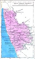
South Canara (South Kannada) was a district of the Madras Presidency of British Raj, located at 13°00′N 75°24′E / 13.00°N 75.40°E.[2] It comprised the towns of Kasaragod and Udupi and adjacent villages, with the administration at Mangalore city. South Canara was one of the most heterogeneous areas of Madras Presidency, with Tulu, Malayalam, Kannada, Konkani, Marathi, Hindustani, and Beary languages being spoken while English, Tamil and Hindustani remained the official languages. It was succeeded by the Tulu-speaking areas of Dakshina Kannada district,[3] the Malayalam-speaking area of Kasaragod district[4] and the Amindivi islands sub-division of the Laccadives,[5] in the year 1956.[6][7][8]
Geography[edit | edit source]
Mangalore was the administrative headquarters of the district. The district covered an area of 10,410 square kilometres (4,021 sq mi).
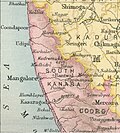
South Canara District was bordered by North Canara to north, the princely state of Mysore to east, Coorg state to southeast, Malabar District to south, and Arabian Sea to west. South Canara was one of the two districts on the western coast (Malabar coast) of Madras Presidency along with Malabar District (otherwise known as Malayalam District).[9][10][11][12]
History[edit | edit source]
South Canara was annexed by the British East India Company following the defeat of Tipu Sultan in the Fourth Mysore War in 1799 and along with North Kanara formed the district of Kanara in the Madras Presidency. In 1859, Kanara was split into two districts, North and South. North Kanara was transferred to the Bombay Presidency, and South was retained by Madras.
Taluks[edit | edit source]

The district was divided into six taluks:
- Amindivi Islands (Laccadives) (Area:7.8 square kilometres (3 sq mi))
- Coondapoor (Area:1,600 square kilometres (619 sq mi); Headquarters: Coondapoor)
- Kasaragod (Area:1,970 square kilometres (762 sq mi); Headquarters: Kasaragod)
- Mangalore (Area:1,760 square kilometres (679 sq mi); Headquarters: Mangalore)
- Udupi (Area:1,860 square kilometres (719 sq mi); Headquarters: Udupi)
- Uppinangady (Area:3,210 square kilometres (1,239 sq mi); Headquarters: Puttur)
Administration[edit | edit source]
The district was administered by a District Collector. For purpose of convenience, the district was divided into three sub-divisions:
- Coondapoor sub-division: Coondapoor and Udupi taluks
- Mangalore sub-division: Mangalore, and the Amindivi islands
- Puttur sub-division: Uppinangady and Kasaragod taluks.
The district had two municipalities, those of Mangalore and Udupi.
Demographics[edit | edit source]

| Year | Pop. | ±% |
|---|---|---|
| 1871 | 918,362 | — |
| 1881 | 959,514 | +4.5% |
| 1891 | 1,056,081 | +10.1% |
| 1901 | 1,134,713 | +7.4% |
| 1941 | 1,522,016 | +34.1% |
| 1951 | 1,748,991 | +14.9% |
| Sources: Imperial Gazetter of India, Volume 14,[13] and 1951 Census Handbook of South Canara[8] | ||
- Hinduism (66.6%)
- Islam (24.3%)
- Christianity (8.85%)
- Other (0.26%)

South Kanara had a total population of 1,748,991 in 1951, of whom 66.58% were Hindu, 24.31% Muslim and 8.85% Christian.[8] The most widely spoken language was Tulu, which was the mother tongue of 40% of the population, followed by Malayalam for 24%, Kannada for 17%, and 13% for Konkani. In 1901, South Kanara had a density of 109 inhabitants per square kilometre (282/sq mi).
The 1908 Imperial Gazetteer of India lists South Canara, along with the Thanjavur and Ganjam districts, as the three districts of the Madras Presidency where Brahmins, one of the four main castes in Hinduism, were most numerous.[13]
The majority of the people were Billavas , Kulala and Bunts. There were more Brahmins (12% of the population) in South Kanara than any other district of the Madras Presidency making South Kanara, along with Tanjore and Ganjam, as one of the three districts of the province where Brahmins were most numerous.[13]
The original indigenous people of the region are Tuluvas (Bunts, Kulalas, Billavas, Mogaveeras, Tulu gowda, Devadigas, Bearys, Jogis) and Malayalis in the Kasaragod Taluk (Nambudiris, Nairs, Thiyyas, Mappilas etc). The Brahmins who settled first belonged chiefly to the Sthanika and thus they were called as Tulu Brahmins. Others were Shivalli, Saraswat, Havyaka, Kotaha sub-sections, Mahars, the hill-tribes (Koragas).[14]
| Language | Number of Speakers | Percent to total population | |
| 1 | Tulu | 698,532 | 39.94% |
|---|---|---|---|
| 2 | Malayalam | 423,037 | 24.19% |
| 3 | Kannada | 300,829 | 17.20% |
| 4 | Konkani | 237,772 | 13.59% |
| 5 | Marathi | 49,991 | 2.86% |
| 6 | Urdu | 17,043 | 0.97% |
| 7 | Hindustani | 13,672 | 0.78% |
| 8 | Tamil | 2,933 | 0.17% |
| 9 | Telugu | 2,382 | 0.14% |
| 10 | Arabic | 1,063 | 0.06% |
| 11 | Others | 1,737 | 0.10% |
See also[edit | edit source]
References[edit | edit source]
- ↑ "Census GIS India". Census of India. Retrieved 26 March 2008.
- ↑ Patsy Lozupone, Bruce M. Beehler, Sidney Dillon Ripley.(2004).Ornithological gazetteer of the Indian subcontinent, p. 82.Center for Applied Biodiversity Science, Conservation International. ISBN 1-881173-85-2.
- ↑ K. Balasubramanyam (1965). 1961 Census Handbook- South Kanara District (PDF). Directorate of Census Operations, Mysore.
- ↑ M. K. Devassy (1965). 1961 Census Handbook- Cannanore District (PDF). Directorate of Census Operations, Kerala and The Union Territory of Laccadive, Minicoy, and Amindivi Islands.
- ↑ P. M. Nair (1979). District Census Handbook -Laccadive, Minicoy, and Amindivi Islands (1971) - Village Directory (PDF). Kavaratti& Government Printing Press, Kozhikode: Administrator and Ex-Officio Director of Census Operations, Laccadive, Minicoy, and Amindivi Island. p. 2.
- ↑ M. K. Devassy (1967). Census of India - 1961 (Kerala) (PDF). Directorate of Census Operations, Kerala and The Union Territory of Laccadive, Minicoy, and Amindivi Islands.
- ↑ J. I. Arputhanathan (1955), South Kanara, The Nilgiris, Malabar and Coimbatore Districts (Village-wise Mother-tongue Data for Bilingual or Multilingual Taluks) (PDF), Madras Government Press
- ↑ 8.0 8.1 8.2 8.3 8.4 8.5 Government of Madras (1953). 1951 Census Handbook- South Canara District (PDF). Madras Government Press. p. 147.
- ↑ J. Sturrock (1894). Madras District Manuals - South Canara (Volume-I). Madras Government Press.
- ↑ Harold A. Stuart (1895). Madras District Manuals - South Canara (Volume-II). Madras Government Press.
- ↑ Government of Madras (1905). Madras District Gazetteers: Statistical Appendix for South Canara District. Madras Government Press.
- ↑ Government of Madras (1915). Madras District Gazetteers South Canara (Volume-II). Madras Government Press.
- ↑ 13.0 13.1 13.2 The Imperial Gazetteer of India. Vol. 14. Clarendon Press. 1908.
- ↑ Silva, Severine; Fuchs, Stephan (1965). "The Marriage Customs of the Christians in South Canara, India". Asian Folklore Studies. 24 (2). Nanzan University: 2–3. doi:10.2307/1177555. JSTOR 1177555.
Further reading[edit | edit source]
- S. Muhammad Hussain Nainar (1942), Tuhfat-al-Mujahidin: An Historical Work in The Arabic Language, University of Madras, ISBN 9789839154801
- J. Sturrock (1894), Madras District Manuals - South Canara (Volume-I), Madras Government Press
- Harold A. Stuart (1895), Madras District Manuals - South Canara (Volume-II), Madras Government Press
- Government of Madras (1905), Madras District Gazetteers: Statistical Appendix for South Canara District, Madras Government Press
- Government of Madras (1915), Madras District Gazetteers South Canara (Volume-II), Madras Government Press
- Government of Madras (1953), 1951 Census Handbook- South Canara District (PDF), Madras Government Press
- J. I. Arputhanathan (1955), South Kanara, The Nilgiris, Malabar and Coimbatore Districts (Village-wise Mother-tongue Data for Bilingual or Multilingual Taluks) (PDF), Madras Government Press
- Rajabhushanam, D. S. (1963), Statistical Atlas of the Madras State (1951) (PDF), Madras (Chennai): Director of Statistics, Government of Madras
External links[edit | edit source]
- South Canara by Vikas Kamat from Kamat.com