



m updated details |
|||
| Line 1: | Line 1: | ||
{{Short description|River in India}} | |||
{{for|the [[Carnatic music]] [[raga]]m|Hemavati (ragam)}} | {{for|the [[Carnatic music]] [[raga]]m|Hemavati (ragam)}} | ||
{{Use dmy dates|date=August 2019}} | {{Use dmy dates|date=August 2019}} | ||
| Line 5: | Line 6: | ||
[[File:Gorur Narasimha temple2-1.jpg|thumb]] | [[File:Gorur Narasimha temple2-1.jpg|thumb]] | ||
The '''Hemavati''' is a river in [[Karnataka]] | The '''Hemavati''' is a river in southern India's [[Karnataka]]<ref>{{GEOnet2|32FA8822F54E3774E0440003BA962ED3|Hemāvati River (Approved)}}, [[National Geospatial-Intelligence Agency|United States National Geospatial-Intelligence Agency]]</ref> and an important [[tributary]] of the [[Kaveri]]. | ||
==Origin and course== | ==Origin and course== | ||
The Hemavati River | The source of the Hemavati River lies in the [[Western Ghats]] (Javali village) at an elevation of about {{convert|1,230|m|ft}}.<ref>{{cite web | ||
|url=http://www.karnatakavision.com/karnataka-rivers-dams.php | |url=http://www.karnatakavision.com/karnataka-rivers-dams.php | ||
|archive-url=https://web.archive.org/web/20060429214201/http://karnatakavision.com/karnataka-rivers-dams.php | |||
|url-status=usurped | |||
|archive-date=29 April 2006 | |||
|title=Main Rivers of Karnataka | |title=Main Rivers of Karnataka | ||
|publisher=Karnatakavision.com | |publisher=Karnatakavision.com | ||
|access-date=2006-10-05 | |access-date=2006-10-05 | ||
}}</ref> | }}</ref> Located in [[Mudigere]] taluk of [[Chikmagalur District]] in the state of [[Karnataka]], it flows through [[Hassan District]] where it is joined by its chief tributary the [[Yagachi River]] and then into [[Mandya district]] before joining the Kaveri near [[Krishnarajasagara]]. It is approximately 245 km long and has a drainage area of about 5,410 km<sup>2</sup>.<ref>{{cite web | ||
|url=http://www.india9.com/i9show/42551.htm | |url=http://www.india9.com/i9show/42551.htm | ||
|title=Hemavati River | |title=Hemavati River | ||
| Line 21: | Line 25: | ||
==Hemavati Dam and Reservoir== | ==Hemavati Dam and Reservoir== | ||
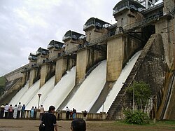
[[Gorur dam]] across the Hemavati was completed in 1979 above Gorur in Hassan district and downstream from the Yagachi confluence. The dam is a [[masonry dam]] with a central spillway through six radial gates. It is 44.5 meters in height and 4692 meters long with an area of 9162 hectares. The reservoir has a live storage capacity of 35.7 [[Tmcft|TMC]].<ref>{{Cite web|url=http://waterresources.kar.nic.in/salient_features_hemavathy.htm|title=Hemavathy Reservoir Project}}</ref> | |||
The dam provides irrigation and drinking water not only for major portion of Hassan and Mandya districts, but also to far away regions of [[Tumkur]] district, that fall under [[Krishna River]] basin.<ref>{{cite web|url=https://www.newindianexpress.com/states/karnataka/2020/dec/02/bsy-fulfils-bypoll-promise-hemavathiwater-reaches-madaluru-tank-in-sira-2230706.html|access-date=2 December 2020|title= Tributary of Cauvery reaches Krishna Basin}}</ref> | |||
The [[Shettihalli Rosary Church]], which was submerged during the construction of the dam can be seen only when the water level is low during the summer months. The church was constructed by [[ | The [[Shettihalli Rosary Church]], which was submerged during the construction of the dam, can be seen only when the water level is low during the summer months. The church was constructed in the [[Gothic Architecture|Gothic]] architectural style by French [[Missionary|missionaries]] in the 1860s. The church was abandoned in 1960 when the government decided to build the dam. When the water level is low [[coracle]]s are used to go inside the church.<ref name=Deccan>{{cite news|title=Rising out of the waters|url=http://www.deccanherald.com/content/435803/rising-waters.html|access-date=16 January 2015|issue=Bangalore|publisher=Deccan Herald|date=13 October 2014}}</ref><ref name=NG>{{cite journal|last1=Singh|first1=Gurdyal|title=Rosary Church at Shettihalli (emerges and submerges)|journal=National Geographic Traveller|date=2013|url=http://travel.nationalgeographic.com/travel/traveler-magazine/photo-contest/2013/entries/205028/view/|archive-url=https://web.archive.org/web/20130506030613/http://travel.nationalgeographic.com/travel/traveler-magazine/photo-contest/2013/entries/205028/view|url-status=dead|archive-date=6 May 2013|access-date=16 January 2015}}</ref> | ||
==Footnotes== | ==Footnotes== | ||
| Line 39: | Line 44: | ||
[[Category:Rivers of Karnataka]] | [[Category:Rivers of Karnataka]] | ||
[[Category:Dams in Karnataka]] | [[Category:Dams in Karnataka]] | ||
{{Karnataka-geo-stub}} | {{Karnataka-geo-stub}} | ||
{{India-river-stub}} | {{India-river-stub}} | ||
Latest revision as of 16:45, 13 September 2025


The Hemavati is a river in southern India's Karnataka[1] and an important tributary of the Kaveri.
Origin and course[edit | edit source]
The source of the Hemavati River lies in the Western Ghats (Javali village) at an elevation of about 1,230 metres (4,040 ft).[2] Located in Mudigere taluk of Chikmagalur District in the state of Karnataka, it flows through Hassan District where it is joined by its chief tributary the Yagachi River and then into Mandya district before joining the Kaveri near Krishnarajasagara. It is approximately 245 km long and has a drainage area of about 5,410 km2.[3]
Hemavati Dam and Reservoir[edit | edit source]
Gorur dam across the Hemavati was completed in 1979 above Gorur in Hassan district and downstream from the Yagachi confluence. The dam is a masonry dam with a central spillway through six radial gates. It is 44.5 meters in height and 4692 meters long with an area of 9162 hectares. The reservoir has a live storage capacity of 35.7 TMC.[4] The dam provides irrigation and drinking water not only for major portion of Hassan and Mandya districts, but also to far away regions of Tumkur district, that fall under Krishna River basin.[5]
The Shettihalli Rosary Church, which was submerged during the construction of the dam, can be seen only when the water level is low during the summer months. The church was constructed in the Gothic architectural style by French missionaries in the 1860s. The church was abandoned in 1960 when the government decided to build the dam. When the water level is low coracles are used to go inside the church.[6][7]
Footnotes[edit | edit source]
- ↑ Template:GEOnet2, United States National Geospatial-Intelligence Agency
- ↑ "Main Rivers of Karnataka". Karnatakavision.com. Archived from the original on 29 April 2006. Retrieved 5 October 2006.
- ↑ "Hemavati River". www.india9.com. Retrieved 5 October 2006.
- ↑ "Hemavathy Reservoir Project".
- ↑ "Tributary of Cauvery reaches Krishna Basin". Retrieved 2 December 2020.
- ↑ "Rising out of the waters". No. Bangalore. Deccan Herald. 13 October 2014. Retrieved 16 January 2015.
- ↑ Singh, Gurdyal (2013). "Rosary Church at Shettihalli (emerges and submerges)". National Geographic Traveller. Archived from the original on 6 May 2013. Retrieved 16 January 2015.
External links[edit | edit source]
12°34′N 76°27′E / 12.567°N 76.450°E
 | This article related to a location in Karnataka is a stub. You can help Bharatpedia by expanding it. |