


imported>Tom.Reding m +{{Authority control}} (1 ID from Wikidata), WP:GenFixes on |
enhance formatting to improve readability and cleaned formatting |
||
| Line 1: | Line 1: | ||
{{Short description|River in India}} | |||
{{Redirect-distinguish|Nagavali|Nagavalli (disambiguation){{!}}Nagavalli}} | {{Redirect-distinguish|Nagavali|Nagavalli (disambiguation){{!}}Nagavalli}} | ||
{{Use dmy dates|date=February 2018}} | {{Use dmy dates|date=February 2018}} | ||
| Line 4: | Line 5: | ||
{{Infobox river | {{Infobox river | ||
| name = Nagavali | | name = Nagavali | ||
| | | native_name = | ||
| | | native_name_lang = | ||
| name_other = Langulya | | name_other = Langulya | ||
| name_etymology = | | name_etymology = | ||
| Line 30: | Line 31: | ||
| subdivision_name5 = | | subdivision_name5 = | ||
<!---------------------- PHYSICAL CHARACTERISTICS --> | <!---------------------- PHYSICAL CHARACTERISTICS --> | ||
| | | length_km = 256.5 | ||
| length_ref = approx. | |||
| width_min = | | width_min = | ||
| width_avg = | | width_avg = | ||
| Line 39: | Line 41: | ||
| discharge1_location= [[Bay of Bengal]] | | discharge1_location= [[Bay of Bengal]] | ||
| discharge1_min = | | discharge1_min = | ||
| discharge1_avg = {{convert| | | discharge1_avg = {{convert|35|m3/s|cuft/s|abbr=on}} | ||
| discharge1_max = | | discharge1_max = | ||
<!---------------------- BASIN FEATURES --> | <!---------------------- BASIN FEATURES --> | ||
| Line 62: | Line 64: | ||
[[File:Nagavali river2.JPG|thumb|Nagavali river near [[Srikakulam]].]] | [[File:Nagavali river2.JPG|thumb|Nagavali river near [[Srikakulam]].]] | ||
[[File:Nagavali river1.JPG|thumb|Nagavali river near Srikakulam.]] | [[File:Nagavali river1.JPG|thumb|Nagavali river near Srikakulam.]] | ||
The '''River Nagavali''' also known as '''Langulya''' is one of the main rivers of Southern [[Odisha]] and | The '''River Nagavali''' also known as '''Langulya''' is one of the main rivers of Southern [[Odisha]] and [[Andhra]] States in [[India]],<ref>{{Cite web |url=http://cwc.nic.in/Integrated_Hydrological_Data_2005/Integrated_Hydrological_Data_2005.pdf |title=Nagavali.CWC |access-date=12 April 2007 |archive-url=https://web.archive.org/web/20110721163524/http://cwc.nic.in/Integrated_Hydrological_Data_2005/Integrated_Hydrological_Data_2005.pdf |archive-date=21 July 2011 |url-status=live }}</ref> between [[Rushikulya]] and [[Godavari River|Godavari]] basins. | ||
==Origin and course== | ==Origin and course== | ||
Nagavali River originates from a hill near [[Lakhbahal]] village in [[Thuamul Rampur]] block of [[Kalahandi]] District. It touches Nakrundi, Kerpai areas of Kalahandi, Kalyansinghpur and Rayagada of [[Rayagada]] district of [[Odisha]] and | Nagavali River originates from a hill near [[Lakhbahal]] village in [[Thuamul Rampur]] block of [[Kalahandi]] District. It touches Nakrundi, Kerpai areas of Kalahandi, Kalyansinghpur, [[Jaykaypur]], and Rayagada of [[Rayagada]] district of [[Odisha]] and merges in Bay of Bengal near Kallepalli village near Srikakulam after crossing by the side of Srikakulam of [[Andhra Pradesh]]. It is an independent river with its own basin. | ||
The total length of the river is about {{convert|256|km|mi}}, of which {{convert|161|km|mi}} are in Odisha and the rest in Andhra Pradesh. The catchment area of the basin is {{convert|9510|km2|sqmi}}. Nagavali is an interstate river with {{convert|4462|km2|sqmi}} and {{convert|5048|km2|sqmi}} river basin area located in Odisha and Andhra Pradesh respectively. The river basin receives {{convert|1000|mm|in}} average | The total length of the river is about {{convert|256|km|mi}}, of which {{convert|161|km|mi}} are in Odisha and the rest in Andhra Pradesh. The catchment area of the basin is {{convert|9510|km2|sqmi}}. Nagavali is an interstate river with {{convert|4462|km2|sqmi}} and {{convert|5048|km2|sqmi}} river basin area located in Odisha and Andhra Pradesh respectively. The river basin receives {{convert|1000|mm|in}} average rainfall annually. The yearly water availability in the river basin at Narayanapuram barrage is 1.117 billion cubic meters on average.<ref name=naga/> The uplands of the river basin are hilly areas with predominantly tribal populated. It drains parts of the Kalahandi, Rayagada and Koraput districts of Odisha and [[Srikakulam]], [[Vizianagaram]] districts of [[Andhra Pradesh]]. | ||
==Tributaries== | ==Tributaries== | ||
The main tributaries of the River Nagavali are Jhanjavati, Barha, Baldiya, Satnala, Sitagurha, Srikona, Gumudugedda, Vottigedda, Suvarnamukhi, Vonigedda, Relligedda and Vegavati. The Suvarnamukhi river takes its birth in the hills of [[Salur]] mandal and takes an eastern direction and finally join the Nagavali at [[Sangam, Srikakulam district|Sangam]] village in [[Vangara, Srikakulam|Vangara]] mandal of [[Srikakulam District]]. Vegavathi originates in pachipenta hills of [[Pachipenta]] Mandal. | The main tributaries of the River Nagavali are Jhanjavati, Barha, Baldiya, Satnala, Sitagurha, Srikona, Gumudugedda, Vottigedda, Suvarnamukhi, Vonigedda, Relligedda and Vegavati. The Suvarnamukhi river takes its birth in the hills of [[Salur]] mandal and takes an eastern direction and finally join the Nagavali at [[Sangam, Srikakulam district|Sangam]] village in [[Vangara, Srikakulam|Vangara]] mandal of [[Srikakulam District]]. Vegavathi originates in pachipenta hills of [[Pachipenta]] Mandal. | ||
*'''Vegavathi River''' takes its origin in the [[Pachipenta]] hills in [[Eastern Ghats]]. It is a tributary to Suvarnamukhi, which in turn is a tributary to River Nagavali. [[Salur]] town and [[Paradhi]] are located on the banks of this river. There are two [[road bridge]]s at these places. | *'''Vegavathi River''' takes its origin in the [[Pachipenta]] hills in [[Eastern Ghats]]. It is a tributary to the Suvarnamukhi, which in turn is a tributary to River Nagavali. [[Salur]] town and [[Paradhi]] are located on the banks of this river. There are two [[road bridge]]s at these places. | ||
==Towns and cities== | ==Towns and cities== | ||
*[[Rayagada]] town and district headquarters of Rayagada | *[[Jaykaypur]]: Nagavali river flows near to Jaykaypur. It has been one of the major source of water for companies like JK Paper Limited, a company of [[JK Organisation|JK Organization]]. | ||
*[[Srikakulam]] town, the district headquarters in [[Andhra Pradesh]]: River Nagavali flows through Srikakulam town and meets the sea at [[ | *[[Rayagada]] town and district headquarters of Rayagada district of Odisha, River Nagavali flows in outskirts of the town. | ||
*[[Hatipathar, Rayagada|Hatipathar]], near [[Rayagada]]: | *[[Srikakulam]] town, the district headquarters in [[Andhra Pradesh]]: River Nagavali flows through Srikakulam town and meets the sea at [[Pedda Ganagalla Peta]] village, 5 kilometers far from Srikakulam town. | ||
*[[Hatipathar, Rayagada|Hatipathar]], near [[Rayagada]]: There are two waterfalls on the course of River Nagavali. The boulders here appear in a way that look like huge elephants.{{fact|date=July 2024}} | |||
==Irrigation projects== | ==Irrigation projects== | ||
[[File:Janjavathi Rubber Dam.jpg|thumb|300px|Janjavathi Rubber Dam]] | [[File:Janjavathi Rubber Dam.jpg|thumb|300px|Janjavathi Rubber Dam]] | ||
*'''Jhanjavati Project''' {{coord|18|51|49|N|83|26|05|E|name= Jhanjavati reservoir}} is located at Rajyalaxmipuram village in [[Komarada]] mandal of [[ | *'''Jhanjavati Project''' {{coord|18|51|49|N|83|26|05|E|name= Jhanjavati reservoir}} is located at Rajyalaxmipuram village in [[Komarada]] mandal of [[Parvathipuram Manyam district]] on Jhanjavati, a tributary of River Nagavali.<ref>{{cite web |url= http://india-wris.nrsc.gov.in/wrpinfo/index.php?title=Jhanjhavathi_/_Janjavathi_Dam_D01971 |title= Janjavathi Dam D01971 |access-date= 5 September 2016 |archive-url= https://web.archive.org/web/20160821120423/http://india-wris.nrsc.gov.in/wrpinfo/index.php?title=Jhanjhavathi_%2F_Janjavathi_Dam_D01971 |archive-date= 21 August 2016 |url-status= dead }}</ref> It is a rubber dam and first of its kind in Andhra Pradesh and [[India]] and the biggest in [[Asia]].<ref>{{Cite web |url=http://www.hindu.com/2006/05/16/stories/2006051613070300.htm |title=The Hindu on Jhanjavati Project |access-date=12 April 2007 |archive-url=https://web.archive.org/web/20071001005008/http://www.hindu.com/2006/05/16/stories/2006051613070300.htm |archive-date=1 October 2007 |work=[[The Hindu]] |date=2006-05-16 |url-status=dead }}</ref><ref>{{Cite web |url=http://old.projectsmonitor.com/detailnews.asp?newsid=10316 |title=First rubber dam in Andhra, tackles dispute over Jhanjavati river with Orissa |access-date=8 June 2014 |archive-url=https://web.archive.org/web/20161001224537/http://old.projectsmonitor.com/detailnews.asp?newsid=10316 |archive-date=1 October 2016 |url-status=dead }}</ref> It is aimed to utilize 4 TMC of available water and to irrigate / stabilize a total ayacut of {{convert|24640|acre|ha}} in Parvathipuram Manyam District. It was dedicated to the nation on 1 January 2006 by Chief Minister [[Y. S. Rajasekhara Reddy]]. The rubber dam was installed on a concrete plate in technical collaboration with Hydro-Construct of [[Austria]]. However, the prior agreement between [[Odisha]] and Andhra Pradesh on this project permits to increase the maximum reservoir level submerging Odisha area up to {{convert|480|ft|m}} msl. This dispute is unsettled till now preventing the use of the project's full irrigation potential for the last 20 years due to the 0.6 [[tmcft]] reservoir storage capacity against 4 tmcft planned storage.<ref>{{Cite web |url=http://cwc.gov.in/main/downloads/legal_instruments_3.pdf |title=Agreements with Odisha on Nagavali river waters sharing - pages 258, 259 & 263 |access-date=17 November 2013 |archive-url=https://web.archive.org/web/20111110160934/http://cwc.gov.in/main/downloads/legal_instruments_3.pdf |archive-date=10 November 2011 |url-status=dead }}</ref> Andhra Pradesh wants to resolve the issue by constituting Nagavali water dispute tribunal under the [[Interstate River Water Disputes Act]] as the dispute is not getting settled by negotiations between the two states. | ||
*'''[[Thotapalli Barrage]]''' is located on Nagavali River at village Thotapalli in [[ | *'''[[Thotapalli Barrage]]''' is located on Nagavali River at village Thotapalli in [[Parvathipuram Manyam district]] and presently being upgraded as barrage.<ref>{{cite web |url= http://india-wris.nrsc.gov.in/wrpinfo/index.php?title=Thotapalli_Barrage_B00429 |title= Thotapalli Barrage B00429 |access-date= 5 September 2016 |archive-url= https://web.archive.org/web/20161003185504/http://india-wris.nrsc.gov.in/wrpinfo/index.php?title=Thotapalli_Barrage_B00429 |archive-date= 3 October 2016 |url-status= live }}</ref> | ||
*'''Madduvalasa Reservoir''' is located at [[Madduvalasa]] village in [[Vangara, Srikakulam|Vangara]] mandal of [[Srikakulam district]]. It is built across Maddigedda tributary. The project is started in 1977 and provides water for {{convert|24500|acre|ha}} of land for cultivation.<ref>{{cite web |url= http://india-wris.nrsc.gov.in/wrpinfo/index.php?title=Madduvalasa_Dam_D02113 |title= Madduvalasa Dam D02113 |access-date= 5 September 2016 |archive-url= https://web.archive.org/web/20160821182232/http://india-wris.nrsc.gov.in/wrpinfo/index.php?title=Madduvalasa_Dam_D02113 |archive-date= 21 August 2016 |url-status= live }}</ref> | *'''Madduvalasa Reservoir''' is located at [[Madduvalasa]] village in [[Vangara, Srikakulam|Vangara]] mandal of [[Srikakulam district]]. It is built across the Maddigedda tributary. The project is started in 1977 and provides water for {{convert|24500|acre|ha}} of land for cultivation.<ref>{{cite web |url= http://india-wris.nrsc.gov.in/wrpinfo/index.php?title=Madduvalasa_Dam_D02113 |title= Madduvalasa Dam D02113 |access-date= 5 September 2016 |archive-url= https://web.archive.org/web/20160821182232/http://india-wris.nrsc.gov.in/wrpinfo/index.php?title=Madduvalasa_Dam_D02113 |archive-date= 21 August 2016 |url-status= live }}</ref> | ||
*'''Vengalaraya Sagar''' {{coord|18|38|31|N|83|11|15|E|name=Vengala Rao Sagar}} with twin reservoirs to supply irrigation water, is located on Suvarnamukhi sub-tributary in the upstream of Madduvalasa Reservoir. | *'''Vengalaraya Sagar''' {{coord|18|38|31|N|83|11|15|E|name=Vengala Rao Sagar}} with twin reservoirs to supply irrigation water, is located on Suvarnamukhi sub-tributary in the upstream of Madduvalasa Reservoir. | ||
*'''Peddagadda reservoir''' {{coord|18|27|55|N|83|06|47|E|name=Peddagadda reservoir}} is also located on Peddagadda sub-tributary in the upstream of Madduvalasa Reservoir. | *'''Peddagadda reservoir''' {{coord|18|27|55|N|83|06|47|E|name=Peddagadda reservoir}} is also located on Peddagadda sub-tributary in the upstream of Madduvalasa Reservoir. | ||
*'''Narayanapuram barrage''' {{coord|18|29|07|N|83|48|31|E|name= Narayanapuram anicut}} is located in [[Burja, Srikakulam|Burja]] mandal of [[Srikakulam district]] across Nagavali River.<ref>{{cite web |url= http:// | *'''Narayanapuram barrage''' {{coord|18|29|07|N|83|48|31|E|name= Narayanapuram anicut}} is located in [[Burja, Srikakulam|Burja]] mandal of [[Srikakulam district]] across Nagavali River.<ref name=naga>{{cite web |url= http://apcada.in/APIIATP/Apiiatp_Ref_Files/Documents/SRIKAKULAM_irrigation%20Profile.pdf |title= Srikakulam district irrigation profile |access-date= 5 August 2022}}</ref> | ||
*'''Vamsadhara and Nagavali inter link canal''' is a {{convert|30|km|mi|abbr=on}} long gravity canal planned to inter link the [[Vamsadhara River|Vamsadhara]] and Nagavali Rivers.<ref>{{cite web |url= | *'''Vamsadhara and Nagavali inter link canal''' is a {{convert|30|km|mi|abbr=on}} long gravity canal planned to inter link the [[Vamsadhara River|Vamsadhara]] and Nagavali Rivers.<ref>{{cite web |url= https://www.deccanchronicle.com/nation/current-affairs/050916/ap-plans-to-link-vamsadhara-nagavali.html |title= AP plans to link Vamsadhara, Nagavali |access-date= 5 September 2016 |archive-url= https://web.archive.org/web/20160905134130/http://www.deccanchronicle.com/nation/current-affairs/050916/ap-plans-to-link-vamsadhara-nagavali.html |archive-date= 5 September 2016 |url-status= live }}</ref> It will run from Hiramandalam reservoir to Narayanapuram barrage near [[Amudalavalasa]] and bring an additional {{convert|50000|acre|ha}} of ayacut under irrigation using 10 [[tmcft]] of water from Vamsadhara basin.<ref>{{cite web |url= https://www.deccanchronicle.com/nation/current-affairs/050916/ap-plans-to-link-vamsadhara-nagavali.html |title= Hiramandalam Dam D03520 |access-date= 5 September 2016 |archive-url= https://web.archive.org/web/20160905134130/http://www.deccanchronicle.com/nation/current-affairs/050916/ap-plans-to-link-vamsadhara-nagavali.html |archive-date= 5 September 2016 |url-status= live }}</ref> | ||
==Pumped storage hydropower projects== | |||
Nearly 9200 MW capacity [[Power sector of Andhra Pradesh#Pumped storage hydroelectricity projects|pumped-storage hydropower plants]] can be installed using the existing reservoirs to meet the renewable and green power needs of the Uttara Andhra region. | |||
==See also== | ==See also== | ||
{{col | {{div col|colwidth=22em}} | ||
*[[Vamsadhara River]] | *[[Vamsadhara River]] | ||
*[[Krishna Water Disputes Tribunal]] | *[[Krishna Water Disputes Tribunal]] | ||
*[[Polavaram Project]] | *[[Polavaram Project]] | ||
*[[Sriram Sagar Project]] | *[[Sriram Sagar Project]] | ||
*[[Nizam Sagar]] | *[[Nizam Sagar]] | ||
*[[Balimela Reservoir]] | *[[Balimela Reservoir]] | ||
*[[Penner River]] | *[[Penner River]] | ||
*[[Palar River]] | *[[Palar River]] | ||
{{div col end}} | |||
==References== | ==References== | ||
| Line 122: | Line 124: | ||
[[Category:Inter-state disputes in India]] | [[Category:Inter-state disputes in India]] | ||
[[Category:Uttarandhra]] | [[Category:Uttarandhra]] | ||
Latest revision as of 23:53, 21 July 2025
| Nagavali Langulya | |
|---|---|
| Location | |
| Country | India |
| Physical characteristics | |
| Source | Lakhbahal |
| • location | Kalahandi |
| Discharge | |
| • location | Bay of Bengal |
| • average | 35 m3/s (1,200 cu ft/s) |


The River Nagavali also known as Langulya is one of the main rivers of Southern Odisha and Andhra States in India,[1] between Rushikulya and Godavari basins.
Origin and course[edit | edit source]
Nagavali River originates from a hill near Lakhbahal village in Thuamul Rampur block of Kalahandi District. It touches Nakrundi, Kerpai areas of Kalahandi, Kalyansinghpur, Jaykaypur, and Rayagada of Rayagada district of Odisha and merges in Bay of Bengal near Kallepalli village near Srikakulam after crossing by the side of Srikakulam of Andhra Pradesh. It is an independent river with its own basin.
The total length of the river is about 256 kilometres (159 mi), of which 161 kilometres (100 mi) are in Odisha and the rest in Andhra Pradesh. The catchment area of the basin is 9,510 square kilometres (3,670 sq mi). Nagavali is an interstate river with 4,462 square kilometres (1,723 sq mi) and 5,048 square kilometres (1,949 sq mi) river basin area located in Odisha and Andhra Pradesh respectively. The river basin receives 1,000 millimetres (39 in) average rainfall annually. The yearly water availability in the river basin at Narayanapuram barrage is 1.117 billion cubic meters on average.[2] The uplands of the river basin are hilly areas with predominantly tribal populated. It drains parts of the Kalahandi, Rayagada and Koraput districts of Odisha and Srikakulam, Vizianagaram districts of Andhra Pradesh.
Tributaries[edit | edit source]
The main tributaries of the River Nagavali are Jhanjavati, Barha, Baldiya, Satnala, Sitagurha, Srikona, Gumudugedda, Vottigedda, Suvarnamukhi, Vonigedda, Relligedda and Vegavati. The Suvarnamukhi river takes its birth in the hills of Salur mandal and takes an eastern direction and finally join the Nagavali at Sangam village in Vangara mandal of Srikakulam District. Vegavathi originates in pachipenta hills of Pachipenta Mandal.
- Vegavathi River takes its origin in the Pachipenta hills in Eastern Ghats. It is a tributary to the Suvarnamukhi, which in turn is a tributary to River Nagavali. Salur town and Paradhi are located on the banks of this river. There are two road bridges at these places.
Towns and cities[edit | edit source]
- Jaykaypur: Nagavali river flows near to Jaykaypur. It has been one of the major source of water for companies like JK Paper Limited, a company of JK Organization.
- Rayagada town and district headquarters of Rayagada district of Odisha, River Nagavali flows in outskirts of the town.
- Srikakulam town, the district headquarters in Andhra Pradesh: River Nagavali flows through Srikakulam town and meets the sea at Pedda Ganagalla Peta village, 5 kilometers far from Srikakulam town.
- Hatipathar, near Rayagada: There are two waterfalls on the course of River Nagavali. The boulders here appear in a way that look like huge elephants.[citation needed]
Irrigation projects[edit | edit source]

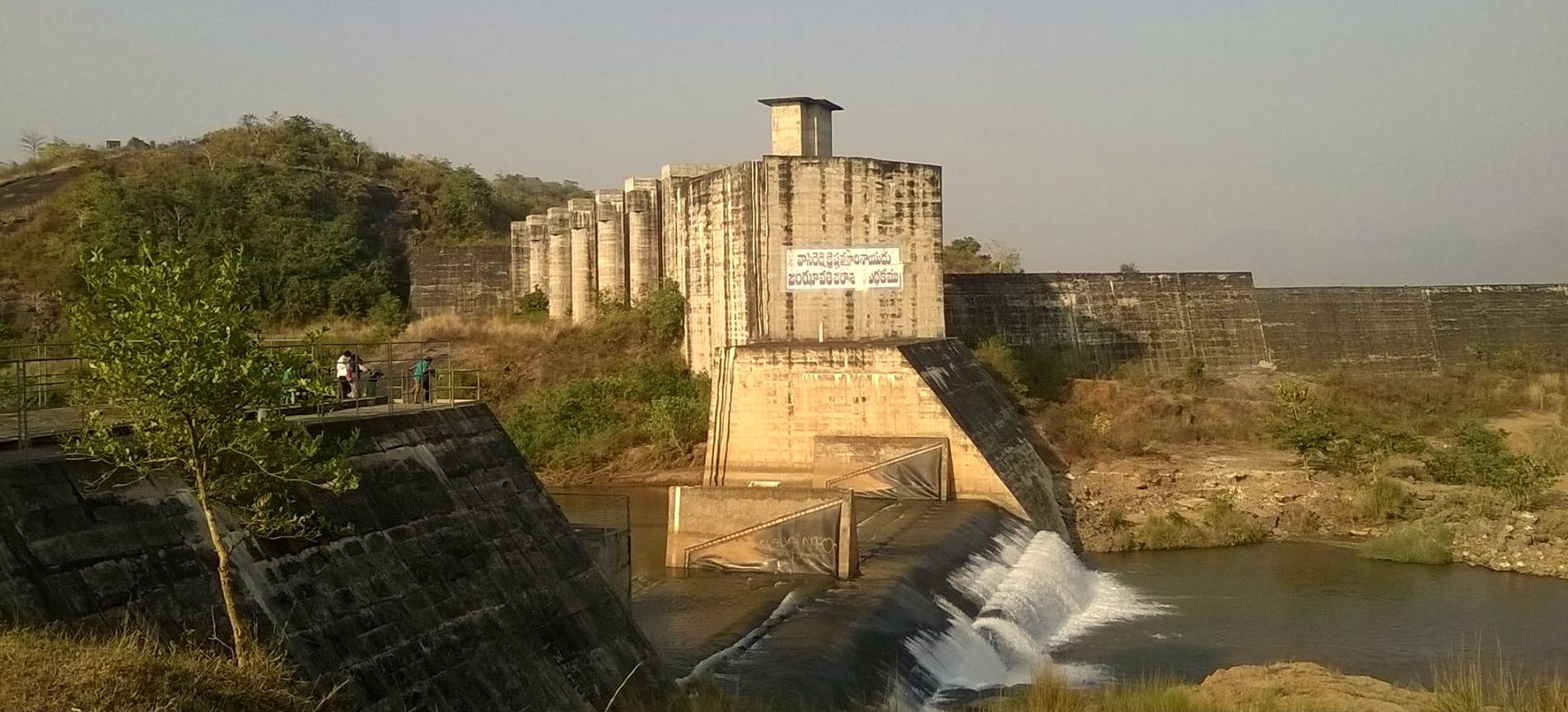
- Jhanjavati Project 18°51′49″N 83°26′05″E / 18.86361°N 83.43472°E is located at Rajyalaxmipuram village in Komarada mandal of Parvathipuram Manyam district on Jhanjavati, a tributary of River Nagavali.[3] It is a rubber dam and first of its kind in Andhra Pradesh and India and the biggest in Asia.[4][5] It is aimed to utilize 4 TMC of available water and to irrigate / stabilize a total ayacut of 24,640 acres (9,970 ha) in Parvathipuram Manyam District. It was dedicated to the nation on 1 January 2006 by Chief Minister Y. S. Rajasekhara Reddy. The rubber dam was installed on a concrete plate in technical collaboration with Hydro-Construct of Austria. However, the prior agreement between Odisha and Andhra Pradesh on this project permits to increase the maximum reservoir level submerging Odisha area up to 480 feet (150 m) msl. This dispute is unsettled till now preventing the use of the project's full irrigation potential for the last 20 years due to the 0.6 tmcft reservoir storage capacity against 4 tmcft planned storage.[6] Andhra Pradesh wants to resolve the issue by constituting Nagavali water dispute tribunal under the Interstate River Water Disputes Act as the dispute is not getting settled by negotiations between the two states.
- Thotapalli Barrage is located on Nagavali River at village Thotapalli in Parvathipuram Manyam district and presently being upgraded as barrage.[7]
- Madduvalasa Reservoir is located at Madduvalasa village in Vangara mandal of Srikakulam district. It is built across the Maddigedda tributary. The project is started in 1977 and provides water for 24,500 acres (9,900 ha) of land for cultivation.[8]
- Vengalaraya Sagar 18°38′31″N 83°11′15″E / 18.64194°N 83.18750°E with twin reservoirs to supply irrigation water, is located on Suvarnamukhi sub-tributary in the upstream of Madduvalasa Reservoir.
- Peddagadda reservoir 18°27′55″N 83°06′47″E / 18.46528°N 83.11306°E is also located on Peddagadda sub-tributary in the upstream of Madduvalasa Reservoir.
- Narayanapuram barrage 18°29′07″N 83°48′31″E / 18.48528°N 83.80861°E is located in Burja mandal of Srikakulam district across Nagavali River.[2]
- Vamsadhara and Nagavali inter link canal is a 30 km (19 mi) long gravity canal planned to inter link the Vamsadhara and Nagavali Rivers.[9] It will run from Hiramandalam reservoir to Narayanapuram barrage near Amudalavalasa and bring an additional 50,000 acres (20,000 ha) of ayacut under irrigation using 10 tmcft of water from Vamsadhara basin.[10]
Pumped storage hydropower projects[edit | edit source]
Nearly 9200 MW capacity pumped-storage hydropower plants can be installed using the existing reservoirs to meet the renewable and green power needs of the Uttara Andhra region.
See also[edit | edit source]
References[edit | edit source]
- ↑ "Nagavali.CWC" (PDF). Archived (PDF) from the original on 21 July 2011. Retrieved 12 April 2007.
- ↑ 2.0 2.1 "Srikakulam district irrigation profile" (PDF). Retrieved 5 August 2022.
- ↑ "Janjavathi Dam D01971". Archived from the original on 21 August 2016. Retrieved 5 September 2016.
- ↑ "The Hindu on Jhanjavati Project". The Hindu. 16 May 2006. Archived from the original on 1 October 2007. Retrieved 12 April 2007.
- ↑ "First rubber dam in Andhra, tackles dispute over Jhanjavati river with Orissa". Archived from the original on 1 October 2016. Retrieved 8 June 2014.
- ↑ "Agreements with Odisha on Nagavali river waters sharing - pages 258, 259 & 263" (PDF). Archived from the original (PDF) on 10 November 2011. Retrieved 17 November 2013.
- ↑ "Thotapalli Barrage B00429". Archived from the original on 3 October 2016. Retrieved 5 September 2016.
- ↑ "Madduvalasa Dam D02113". Archived from the original on 21 August 2016. Retrieved 5 September 2016.
- ↑ "AP plans to link Vamsadhara, Nagavali". Archived from the original on 5 September 2016. Retrieved 5 September 2016.
- ↑ "Hiramandalam Dam D03520". Archived from the original on 5 September 2016. Retrieved 5 September 2016.