




imported>Qwerfjkl m daated->dated - Fix a typo in one click |
brief refine citations for consistency additionally and updated info |
||
| Line 1: | Line 1: | ||
{{distinguish|Surat|Surat Thani}} | |||
{{original research|date=August 2019}} | {{original research|date=August 2019}} | ||
{{Use dmy dates|date=July 2018}} | {{Use dmy dates|date=July 2018}} | ||
| Line 4: | Line 5: | ||
<!-- See [[Wikipedia:WikiProject Indian cities]] for details --> | <!-- See [[Wikipedia:WikiProject Indian cities]] for details --> | ||
{{Infobox settlement | {{Infobox settlement | ||
| name | | name = Surathkal | ||
| native_name | | native_name = ಸುರತ್ಕಲ್ | ||
| native_name_lang | | native_name_lang = kn | ||
| other_name | | other_name = | ||
| settlement_type | | settlement_type = Neighbourhood/Suburb | ||
| image_skyline | | image_skyline = Surathkal.JPG | ||
| image_alt | | image_alt = | ||
| image_caption | | image_caption = Surathkal Railway Station | ||
| nickname | | nickname = | ||
| pushpin_map | | pushpin_map = India Karnataka | ||
| pushpin_label_position | | pushpin_label_position = right | ||
| pushpin_map_alt | | pushpin_map_alt = | ||
| pushpin_map_caption | | pushpin_map_caption = Location in Karnataka, India | ||
| coordinates | | coordinates = {{coord|12.96932|N|74.77915|E|region:IN|format=dms|display=inline,title}} | ||
| subdivision_type | | subdivision_type = Country | ||
| subdivision_name | | subdivision_name = {{flag|India}} | ||
| subdivision_type1 | | subdivision_type1 = [[States and territories of India|State]] | ||
| subdivision_type2 | | subdivision_type2 = [[List of districts of India|District]] | ||
| subdivision_type3 | | subdivision_type3 = [[City]] | ||
| subdivision_name3 | | subdivision_name3 = [[Mangaluru taluk|Mangaluru]] | ||
| subdivision_type4 | | subdivision_type4 = [[List of regions of India|Region]] | ||
| subdivision_name1 | | subdivision_name1 = [[Karnataka]] | ||
| subdivision_name2 | | subdivision_name2 = [[Dakshina Kannada]] | ||
| subdivision_name4 | | subdivision_name4 = [[Tulu Nadu]] | ||
| established_title | | established_title = <!-- Established --> | ||
| established_date | | established_date = | ||
| founder | | founder = | ||
| named_for | | named_for = | ||
| government_type | | government_type = | ||
| governing_body | | governing_body = | ||
| unit_pref | | unit_pref = Metric | ||
| area_footnotes | | area_footnotes = | ||
| area_total_km2 | | area_total_km2 = | ||
| area_rank | | area_rank = | ||
| elevation_footnotes | | elevation_footnotes = | ||
| elevation_m | | elevation_m = 24 | ||
| population_total | | population_total = 61,259 | ||
| population_as_of | | population_as_of = | ||
| population_footnotes | | population_footnotes = | ||
| population_density_km2 | | population_density_km2 = auto | ||
| population_rank | | population_rank = | ||
| population_demonym | | population_demonym = | ||
| demographics_type1 | | demographics_type1 = Languages | ||
| demographics1_title1 | | demographics1_title1 = Official | ||
| timezone1 | | timezone1 = [[Indian Standard Time|IST]] | ||
| utc_offset1 | | utc_offset1 = +5:30 | ||
| postal_code_type | | postal_code_type = [[Postal Index Number|PIN]] | ||
| postal_code | | postal_code = 575014 | ||
| area_code | | area_code = 0824 | ||
| area_code_type | | area_code_type = Telephone code | ||
| registration_plate | | registration_plate = | ||
| website | | website = | ||
| footnotes | | footnotes = | ||
| demographics1_info1 | | demographics1_info1 = [[Kannada]] | ||
| demographics1_title2 | | demographics1_title2 = Regional | ||
| demographics1_info2 | | demographics1_info2 = Kannada, Tulu, Beary, Konkani | ||
}} | }} | ||
'''Surathkal''' is | '''Surathkal'''(kn:ಸುರತ್ಕಲ್)" is an area (locality) within the city of Mangaluru. It is a municipality merged with [[Mangaluru City Corporation]]. It lies between [[Gurupura]] (Phalguni) and Pavanje (Nandini) rivers. It is the northern suburb and can be considered as the northernmost area of [[Mangaluru]] until [[Mukka]]. Surathkal has a railway station on [[Konkan railway]] route which connects cities of Mumbai to Mangaluru. Surathkal is 8 km north of [[New Mangalore Port|New Mangalore seaport]], 4 km west of [[Mangalore Refinery and Petrochemicals Limited]] and 16 km west of [[Mangalore International Airport]] This region has developed educationally, industrially and commercially can be regarded as one of the crucial localities in [[Mangaluru]] and [[Kanara|coastal Karnataka]]. The only [[National Institute of Technology Karnataka|NIT]] of Karnataka is situated here which is adjacent to the national highway [[National Highway 66 (India)|NH 66]]. [[Mukka]] a popular name in Indian surfing is also situated close to Surathkal. [[NITK Beach|Surathkal beach]] is well known for its cleanliness and well maintained like other beaches in Mangaluru. | ||
==Etymology== | ==Etymology== | ||
According to legend, the name Surathkal is derived from " | According to legend, the name Surathkal is derived from "shiradakal" meaning "headstone" in both [[Kannada language|Kannada]] and [[Tulu language|Tulu]]. The famous Sadashiva Mahaganapathi temple on the shores of [[Arabian Sea]] (Lakshadweepa Samudra) is said to be built around the linga that a [[Rakshasa]] by name Kharasura carried on his head. Another legend is that when [[Ravana]] threw in fit of rage the atma shivalinga, some of the pieces from [[shivalinga]] fell at place where Sadashiva temple is situated at present. Noted historian [[Padoor Gururaj Bhat]] is of opinion the temple might have been constructed around 11 C.E. (11 A.D). | ||
==Administration== | ==Administration== | ||
Surathkal was once a [[Gram panchayat|Grama panchayat]], then [[Town Panchayat (T.P.)|town panchayat]], [[municipality]] vide Government notification No.S.O. 2658 dated 31 | Surathkal was once a [[Gram panchayat|Grama panchayat]], then [[Town Panchayat (T.P.)|town panchayat]], [[municipality]] vide Government notification No.S.O. 2658 dated 31 December 1974<ref>{{cite web|url=https://censusindia.gov.in/nada/index.php/catalog/31011/study-description|title=Karnataka Town Directory, Census of India 1981 Page 14|publisher=Office of Registrar General and Census Commissioner, India|access-date=6 January 2021}}</ref> now merged with [[Mangalore City Corporation]].Zonal office of Mangaluru City Corporation was opened on 6 March 2017 at Surathkal (Zone 1) which covers Surathkal (West), Surathkal (East), Katipalla (West), Katipalla-Krishnapura, Katipalla (North), Idya (East), Idya (West), Hosabettu, Kulai, Baikampady, Panambur and Bengre wards of MCC.<ref>{{cite web|url=https://www.deccanherald.com/india/karnataka/mcc-zonal-office-open-surathkal-1994025|title=MCC zonal office to open in Surathkal today|publisher=Deccan Herald, English Newsdaily|access-date=2 April 2024}}</ref> Surathkal was once a separate constituency of [[Karnataka Legislative Assembly]].The Suratkal legislative assembly constituency was part of [[Udupi (Lok Sabha constituency)]] till the year 2009.<ref>{{cite web |url=https://resultuniversity.com/election/surathkal-karnataka-assembly-constituency|title =Surathkal Assembly Constituency Election Result|accessdate=31 July 2023 |publisher=Result university}}</ref> Now it has been renamed as [[Mangalore City North (Vidhan Sabha constituency)]] after change in its geographical limits and it comes under [[Dakshina Kannada (Lok Sabha constituency)]] at present. | ||
Surathkal is Hobli under Mangaluru taluk as per Karnataka state Revenue Department.<ref>{{cite web |url=https://nadakacheri.karnataka.gov.in/Styles/Documents/NK_address.htm|title =Nadakacheri Address|accessdate=31 July 2023 |publisher= Karnataka state government}}</ref> It has "Nada Katcheri" near Suratkal market which provides property details and other matters related to Revenue department. Surathkal Police station comes under the jurisdiction of Commissioner of Mangaluru city police. | |||
[[File:suratkal1.jpg|thumb|right|Junction of NH-17 and Bajpe road at Suratkal]] | [[File:suratkal1.jpg|thumb|right|Junction of NH-17 and Bajpe road at Suratkal]] | ||
There is Veterinary Hospital run by Karnataka state government at Suratkal.<ref>{{cite web |url=https://ahvs.karnataka.gov.in/page/Institution/Veterinary/en|title =Veterinary|accessdate=31 July 2023|publisher= Karnataka state government}}</ref> Surathkal has [[post office]] operated and maintained by postal department, Government of India, with Postal index number code (Pincode) 575014.<ref>{{cite web|url=https://www.ndtv.com/tools/pincodes/karnataka/dakshina-kannada/surathkal-so|title=Surathkal SO Pin Code, Dakshina Kannada, Karnataka|publisher=NDTV|access-date=13 October 2025}}</ref> | |||
==Education== | ==Education== | ||
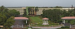
Surathkal is home to one of India's premier technical institutes - The [[National Institute of Technology Karnataka]] (NITK), formerly known as ''Karnataka Regional Engineering College'' (KREC). Surathkal also houses [[Vidyadayanee]] High School and [[Govindadasa College]] run by Hindu Vidyadayanee Sangha, Surathkal. | Surathkal is home to one of India's premier technical institutes - The [[National Institute of Technology Karnataka]] (NITK), formerly known as ''Karnataka Regional Engineering College'' (KREC).<ref>{{cite web |url=https://www.nitk.ac.in/about_us|title =Know NITK Better About Us|accessdate=31 July 2023 |publisher=NITK, Surathkal}}</ref> Surathkal also houses [[Vidyadayanee]] High School and [[Govindadasa College]] run by Hindu Vidyadayanee Sangha, Surathkal.<ref>{{cite web |url=https://govindadasacollege.edu.in/about-college/|title =About College|accessdate=31 July 2023 |publisher=H.V.Sangha}}</ref> Other notable educational institutes include Sri Mahalingeshwara English Medium school, NITK English Medium School, Holy Family School and Anjuman English Medium High School, Mukka. The Srinivas Institute of Medical Science and Research Centre's Hospital is located at Srinivasnagar, Mukka, Surathkal.<ref>{{cite web |url=https://srinivasgroup.com/Srinivas-Institute-of-Medical-Sciences-and-Research-Center/Contact-Us|title =Contact Us|accessdate=31 July 2023 |publisher=Srinivas group}}</ref> | ||
Other notable educational institutes include Sri Mahalingeshwara English Medium school, NITK English Medium School, Holy Family School and Anjuman English Medium High School, Mukka. The Srinivas Institute of Medical Science and Research Centre is located | |||
[[File:NITK mangalore.jpg|thumb|right|NITK Surathkal]] | [[File:NITK mangalore.jpg|thumb|right|NITK Surathkal]] | ||
==Travel== | ==Travel== | ||
Surathkal can be easily accessed by various bus services from [[ | National Highway 66 ( previously NH 17) passes through Surathkal<ref>{{cite web| url=https://theprint.in/india/surathkal-toll-gate-to-be-closed-permanently-from-nov-30/1241150/|title=Surathkal toll gate to be closed permanently from Nov 30|publisher=The Print|access-date = 2 April 2024}}</ref><ref>{{cite web|url=https://www.coastaldigest.com/nagarika-samiti-moves-supreme-court-against-surathkal-toll-gate|title=nagarika samiti moves supreme court against surathkal toll-gate|publisher=Coastal Digest|access-date=2 April 2024}}</ref> Surathkal can be easily accessed by various bus services from [[State Bank, Mangalore|State Bank]] by both city buses and the Mangalore-Udupi Express buses. The nearest airport is [[Mangalore International Airport]] ([[Bajpe]]), 16 kilometres from Surathkal that connects Mangalore with major cities in southern and western India as well as many major cities in the Middle East, with direct flights available to Dubai, Doha, Muscat and Abu Dhabi. [[Surathkal railway station]], which is located 2 km away from the National Institute of Technology campus and half kilometre from national highway NH-66 falls on the famed Konkan railway route on which Rajdhani, Duronto, and other express trains ply regularly from Mangaluru to Mumbai, [[Thane]], Ernakulam, Gujarat and New Delhi. The nearest metropolitan cities, Mumbai and Chennai, are 16 hours away by train. The New Mangalore Sea Port ([[NMPT]]) is situated 8 km away from this town on the Arabian Sea and primarily used for importing and exporting goods all over the world.<ref>{{cite web|url=https://www.deccanherald.com/india/karnataka/dredger-beached-near-surathkal-to-prevent-problems-771997.html|title=Dredger beached near Surathkal to prevent problems|publisher=Deccan Herald|access-date=2 April 2024}}</ref> | ||
==Places | ==Places of interest== | ||
[[File:Sunset at Surathkal Beach.jpg|thumb|Sunset at Surathkal Beach]] | |||
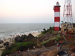
[[File:Surathkal Lighthouse1.jpg|thumb|right|Lighthouse, alongside Surathkal Beach]] | [[File:Surathkal Lighthouse1.jpg|thumb|right|Lighthouse, alongside Surathkal Beach]] | ||
[[File:Shri Ganesha Bhajana Mandira (R.).jpg|thumb|150x150px|Shri Ganesha Bhajana Mandira (R.) at Janatha Colony, Surathkal]] | |||
[[National Institute of Technology Karnataka]] | * Surathkal Beach<ref name = skalbeach>{{cite web |url=http://www.mapsofindia.com/mangalore/travel/surathkal-beach.html|title =Surathkal Beach|accessdate= 2011-09-11 |website=www.mapsofindia.com}}</ref><ref>{{cite web |url=http://www.karnataka.com/surathkal/surathkal-beach/|title =Surathkal Beach – Stretch Your Legs in Surathkal!|accessdate= 2012-08-03 |website=www.karnataka.com|date =2 December 2011}}</ref> There is a [[lighthouse]] at Surathkal Beach which was commissioned in 1972.<ref>{{cite web |url=http://www.dgll.nic.in/WriteReadData/Publication/Publication_Pdf_File/LighthousesofIndia(2).pdf|title =Indian Lighthouses An overview, Page 119|accessdate=27 November 2019 |publisher=Directorate General of Lighthouses and Lightships}}</ref><ref>{{cite web|url=https://www.dgll.nic.in/DGLL-light-house-location/goa/surathkal-lighthouse-and-dgps-station|title=Surathkal Lighthouse and D.G.P.S Station|publisher=Directorate General of Lighthouses and Light ships|access-date= 2 April 2024}}</ref> | ||
* [[National Institute of Technology Karnataka]] | |||
NITK Beach | * [[NITK Beach]] | ||
* [[Surathkal Lighthouse]] | |||
* [[Krishnapura matha]]<ref>{{cite web|url=https://krishnapuramatha.org/sri-krishnapura-matha/|archive-url=https://web.archive.org/web/20220204111841/https://krishnapuramatha.org/sri-krishnapura-matha/|url-status=usurped|archive-date=4 February 2022|title=Welcome to Shri Krishnapura Matha|access-date=2 April 2024}}</ref> | |||
* [[Shri Sadashiva Mahaganapati Temple]] | |||
Surathkal Lighthouse | * [[Iddya Shri Mahalingeshwara Temple]]<ref>{{cite web |url=http://rcmysore-portal.kar.nic.in/temples/IdyaMahalingeshwaraTemple/History.htm#History |title = Idya Shree Mahalingeshwara Temple |accessdate= 2015-12-19 |publisher=rcmysore-portal.kar.nic.in}}</ref> | ||
* [[Padre Shree Dhoomavati Temple]], Padre | |||
[[Krishnapura matha]] | * [[Shri Ganesha Bhajana Mandira]] (R.) [[Janatha Colony]] | ||
Shri Sadashiva Mahaganapati Temple | |||
Iddya Shri Mahalingeshwara Temple | |||
[[ | |||
Padre Shree Dhoomavati Temple, Padre. | |||
==Geography== | ==Geography== | ||
Surathkal is located at 12°58'60 N 74° 46' 60E.<ref>[http://www.fallingrain.com/world/IN/19/Suratakal.html Falling Rain Genomics, Inc - Surathkal]</ref> The maximum and minimum temperature in a year varies between 37 °C and | Surathkal is located at 12°58'60 N 74° 46' 60E.<ref>[http://www.fallingrain.com/world/IN/19/Suratakal.html Falling Rain Genomics, Inc - Surathkal]</ref> The maximum and minimum temperature in a year varies between 37 °C and 25 °C. But ambient temperature occasionally touches 40 °C during summer season (usually March, April, May) | ||
==Industry== | ==Industry== | ||
Some of the major industries in and around Surathkal are [[MRPL]], [[BASF]] and | Some of the major industries in and around Surathkal are: | ||
* Mangalore Refinery and Petrochemicals Limited ([[MRPL]]), | |||
* [[BASF]] (German chemical company) and | |||
* [[Mangalore Chemicals and Fertilizers]] (MCF). | |||
The [[Baikampady]] Industrial Estate is located at around 6 kilometres from Surathkal and houses many small and medium-sized industries. The raw materials for these industries are imported through the [[New Mangalore Port Trust|NMPT]] and goods produced here are transported to several places in India and exported abroad through this port. | |||
==See also== | ==See also== | ||
* [[National Institute of Technology, Karnataka|NITK Surathkal]] | * [[National Institute of Technology, Karnataka|NITK Surathkal]] | ||
* [[NITK Beach]] | * [[NITK Beach]] | ||
* [[Sasihithlu beach]] | * [[Sasihithlu beach]] | ||
* [[Panambur beach]] | * [[Panambur beach]] | ||
* [[New Mangalore Port Trust|NMPT]] | * New Mangalore Port Trust ([[New Mangalore Port Trust|NMPT]]) | ||
==External links== | ==External links== | ||
Latest revision as of 17:01, 18 February 2026
 | This article possibly contains original research. (August 2019) |
Surathkal
ಸುರತ್ಕಲ್ | |
|---|---|
Neighbourhood/Suburb | |
 Surathkal Railway Station | |
  Surathkal Location in Karnataka, India | |
| Coordinates: 12°58′10″N 74°46′45″E / 12.96932°N 74.77915°E | |
| Country |  India India |
| State | Karnataka |
| District | Dakshina Kannada |
| City | Mangaluru |
| Region | Tulu Nadu |
| Elevation | 24 m (79 ft) |
| Population | |
| • Total | 61,259 |
| Languages | |
| • Official | Kannada |
| • Regional | Kannada, Tulu, Beary, Konkani |
| Time zone | UTC+5:30 (IST) |
| PIN | 575014 |
| Telephone code | 0824 |
Surathkal(kn:ಸುರತ್ಕಲ್)" is an area (locality) within the city of Mangaluru. It is a municipality merged with Mangaluru City Corporation. It lies between Gurupura (Phalguni) and Pavanje (Nandini) rivers. It is the northern suburb and can be considered as the northernmost area of Mangaluru until Mukka. Surathkal has a railway station on Konkan railway route which connects cities of Mumbai to Mangaluru. Surathkal is 8 km north of New Mangalore seaport, 4 km west of Mangalore Refinery and Petrochemicals Limited and 16 km west of Mangalore International Airport This region has developed educationally, industrially and commercially can be regarded as one of the crucial localities in Mangaluru and coastal Karnataka. The only NIT of Karnataka is situated here which is adjacent to the national highway NH 66. Mukka a popular name in Indian surfing is also situated close to Surathkal. Surathkal beach is well known for its cleanliness and well maintained like other beaches in Mangaluru.
Etymology[edit | edit source]
According to legend, the name Surathkal is derived from "shiradakal" meaning "headstone" in both Kannada and Tulu. The famous Sadashiva Mahaganapathi temple on the shores of Arabian Sea (Lakshadweepa Samudra) is said to be built around the linga that a Rakshasa by name Kharasura carried on his head. Another legend is that when Ravana threw in fit of rage the atma shivalinga, some of the pieces from shivalinga fell at place where Sadashiva temple is situated at present. Noted historian Padoor Gururaj Bhat is of opinion the temple might have been constructed around 11 C.E. (11 A.D).
Administration[edit | edit source]
Surathkal was once a Grama panchayat, then town panchayat, municipality vide Government notification No.S.O. 2658 dated 31 December 1974[1] now merged with Mangalore City Corporation.Zonal office of Mangaluru City Corporation was opened on 6 March 2017 at Surathkal (Zone 1) which covers Surathkal (West), Surathkal (East), Katipalla (West), Katipalla-Krishnapura, Katipalla (North), Idya (East), Idya (West), Hosabettu, Kulai, Baikampady, Panambur and Bengre wards of MCC.[2] Surathkal was once a separate constituency of Karnataka Legislative Assembly.The Suratkal legislative assembly constituency was part of Udupi (Lok Sabha constituency) till the year 2009.[3] Now it has been renamed as Mangalore City North (Vidhan Sabha constituency) after change in its geographical limits and it comes under Dakshina Kannada (Lok Sabha constituency) at present.
Surathkal is Hobli under Mangaluru taluk as per Karnataka state Revenue Department.[4] It has "Nada Katcheri" near Suratkal market which provides property details and other matters related to Revenue department. Surathkal Police station comes under the jurisdiction of Commissioner of Mangaluru city police.

There is Veterinary Hospital run by Karnataka state government at Suratkal.[5] Surathkal has post office operated and maintained by postal department, Government of India, with Postal index number code (Pincode) 575014.[6]
Education[edit | edit source]
Surathkal is home to one of India's premier technical institutes - The National Institute of Technology Karnataka (NITK), formerly known as Karnataka Regional Engineering College (KREC).[7] Surathkal also houses Vidyadayanee High School and Govindadasa College run by Hindu Vidyadayanee Sangha, Surathkal.[8] Other notable educational institutes include Sri Mahalingeshwara English Medium school, NITK English Medium School, Holy Family School and Anjuman English Medium High School, Mukka. The Srinivas Institute of Medical Science and Research Centre's Hospital is located at Srinivasnagar, Mukka, Surathkal.[9]

Travel[edit | edit source]
National Highway 66 ( previously NH 17) passes through Surathkal[10][11] Surathkal can be easily accessed by various bus services from State Bank by both city buses and the Mangalore-Udupi Express buses. The nearest airport is Mangalore International Airport (Bajpe), 16 kilometres from Surathkal that connects Mangalore with major cities in southern and western India as well as many major cities in the Middle East, with direct flights available to Dubai, Doha, Muscat and Abu Dhabi. Surathkal railway station, which is located 2 km away from the National Institute of Technology campus and half kilometre from national highway NH-66 falls on the famed Konkan railway route on which Rajdhani, Duronto, and other express trains ply regularly from Mangaluru to Mumbai, Thane, Ernakulam, Gujarat and New Delhi. The nearest metropolitan cities, Mumbai and Chennai, are 16 hours away by train. The New Mangalore Sea Port (NMPT) is situated 8 km away from this town on the Arabian Sea and primarily used for importing and exporting goods all over the world.[12]
Places of interest[edit | edit source]


.jpg)
- Surathkal Beach[13][14] There is a lighthouse at Surathkal Beach which was commissioned in 1972.[15][16]
- National Institute of Technology Karnataka
- NITK Beach
- Surathkal Lighthouse
- Krishnapura matha[17]
- Shri Sadashiva Mahaganapati Temple
- Iddya Shri Mahalingeshwara Temple[18]
- Padre Shree Dhoomavati Temple, Padre
- Shri Ganesha Bhajana Mandira (R.) Janatha Colony
Geography[edit | edit source]
Surathkal is located at 12°58'60 N 74° 46' 60E.[19] The maximum and minimum temperature in a year varies between 37 °C and 25 °C. But ambient temperature occasionally touches 40 °C during summer season (usually March, April, May)
Industry[edit | edit source]
Some of the major industries in and around Surathkal are:
- Mangalore Refinery and Petrochemicals Limited (MRPL),
- BASF (German chemical company) and
- Mangalore Chemicals and Fertilizers (MCF).
The Baikampady Industrial Estate is located at around 6 kilometres from Surathkal and houses many small and medium-sized industries. The raw materials for these industries are imported through the NMPT and goods produced here are transported to several places in India and exported abroad through this port.
See also[edit | edit source]
- NITK Surathkal
- NITK Beach
- Sasihithlu beach
- Panambur beach
- New Mangalore Port Trust (NMPT)
External links[edit | edit source]
References[edit | edit source]
- ↑ "Karnataka Town Directory, Census of India 1981 Page 14". Office of Registrar General and Census Commissioner, India. Retrieved 6 January 2021.
- ↑ "MCC zonal office to open in Surathkal today". Deccan Herald, English Newsdaily. Retrieved 2 April 2024.
- ↑ "Surathkal Assembly Constituency Election Result". Result university. Retrieved 31 July 2023.
- ↑ "Nadakacheri Address". Karnataka state government. Retrieved 31 July 2023.
- ↑ "Veterinary". Karnataka state government. Retrieved 31 July 2023.
- ↑ "Surathkal SO Pin Code, Dakshina Kannada, Karnataka". NDTV. Retrieved 13 October 2025.
- ↑ "Know NITK Better About Us". NITK, Surathkal. Retrieved 31 July 2023.
- ↑ "About College". H.V.Sangha. Retrieved 31 July 2023.
- ↑ "Contact Us". Srinivas group. Retrieved 31 July 2023.
- ↑ "Surathkal toll gate to be closed permanently from Nov 30". The Print. Retrieved 2 April 2024.
- ↑ "nagarika samiti moves supreme court against surathkal toll-gate". Coastal Digest. Retrieved 2 April 2024.
- ↑ "Dredger beached near Surathkal to prevent problems". Deccan Herald. Retrieved 2 April 2024.
- ↑ "Surathkal Beach". www.mapsofindia.com. Retrieved 11 September 2011.
- ↑ "Surathkal Beach – Stretch Your Legs in Surathkal!". www.karnataka.com. 2 December 2011. Retrieved 3 August 2012.
- ↑ "Indian Lighthouses An overview, Page 119" (PDF). Directorate General of Lighthouses and Lightships. Retrieved 27 November 2019.
- ↑ "Surathkal Lighthouse and D.G.P.S Station". Directorate General of Lighthouses and Light ships. Retrieved 2 April 2024.
- ↑ "Welcome to Shri Krishnapura Matha". Archived from the original on 4 February 2022. Retrieved 2 April 2024.
- ↑ "Idya Shree Mahalingeshwara Temple". rcmysore-portal.kar.nic.in. Retrieved 19 December 2015.
- ↑ Falling Rain Genomics, Inc - Surathkal