

Ajay Kumar (talk | contribs) Created a new article |
No edit summary |
||
| Line 1: | Line 1: | ||
{{short description|International road network connecting Asia and parts of Europe}} | {{short description|International road network connecting Asia and parts of Europe}} | ||
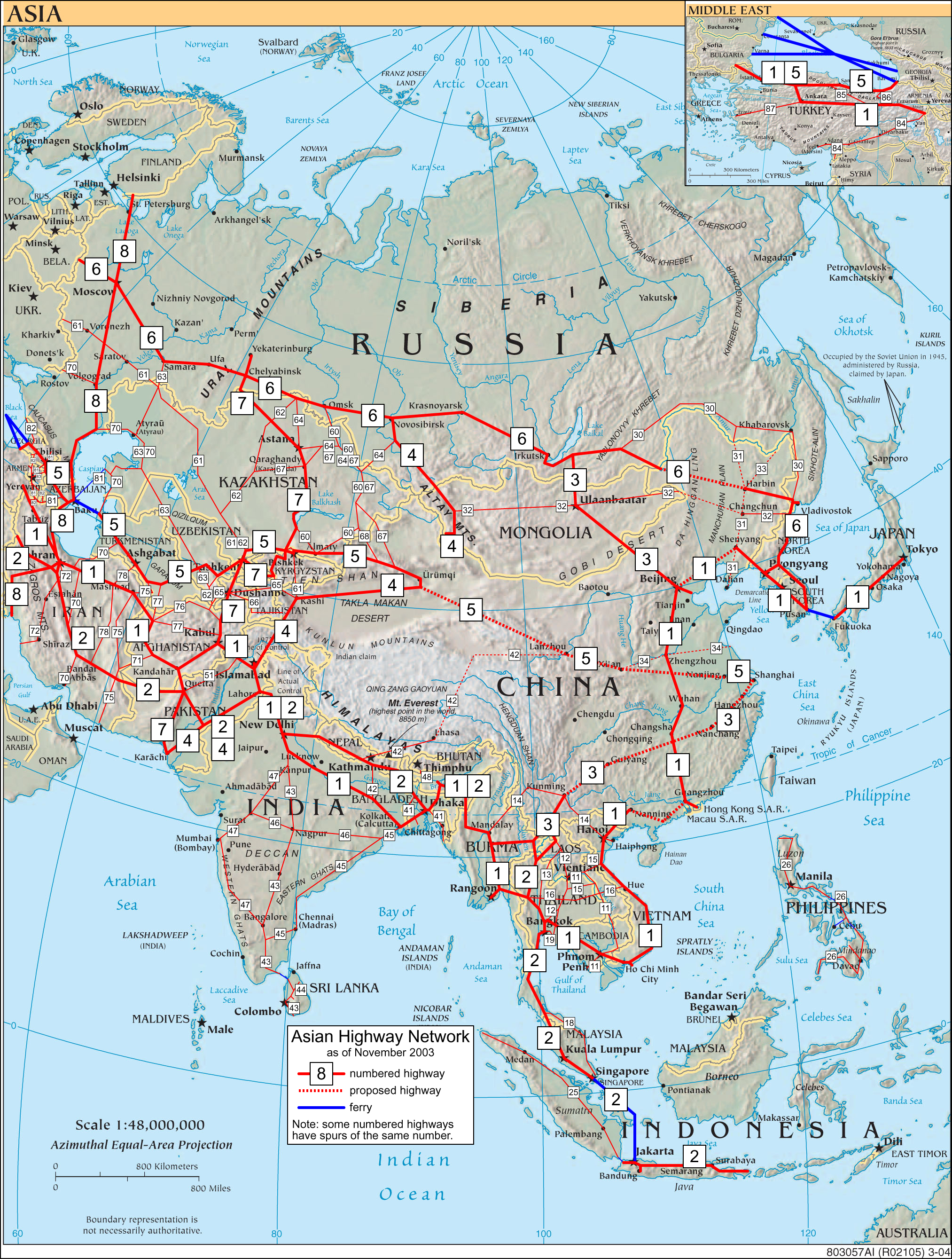
[[Image:Asian Highways.png|thumb | [[Image:Asian Highways.png|thumb|Map of the highways]] | ||
[[Image:Asian highway 2 Ratchaburi.jpg | [[Image:Asian highway 2 Ratchaburi.jpg|thumb|Asian Highway 2 sign near [[Ratchaburi]], Thailand]] | ||
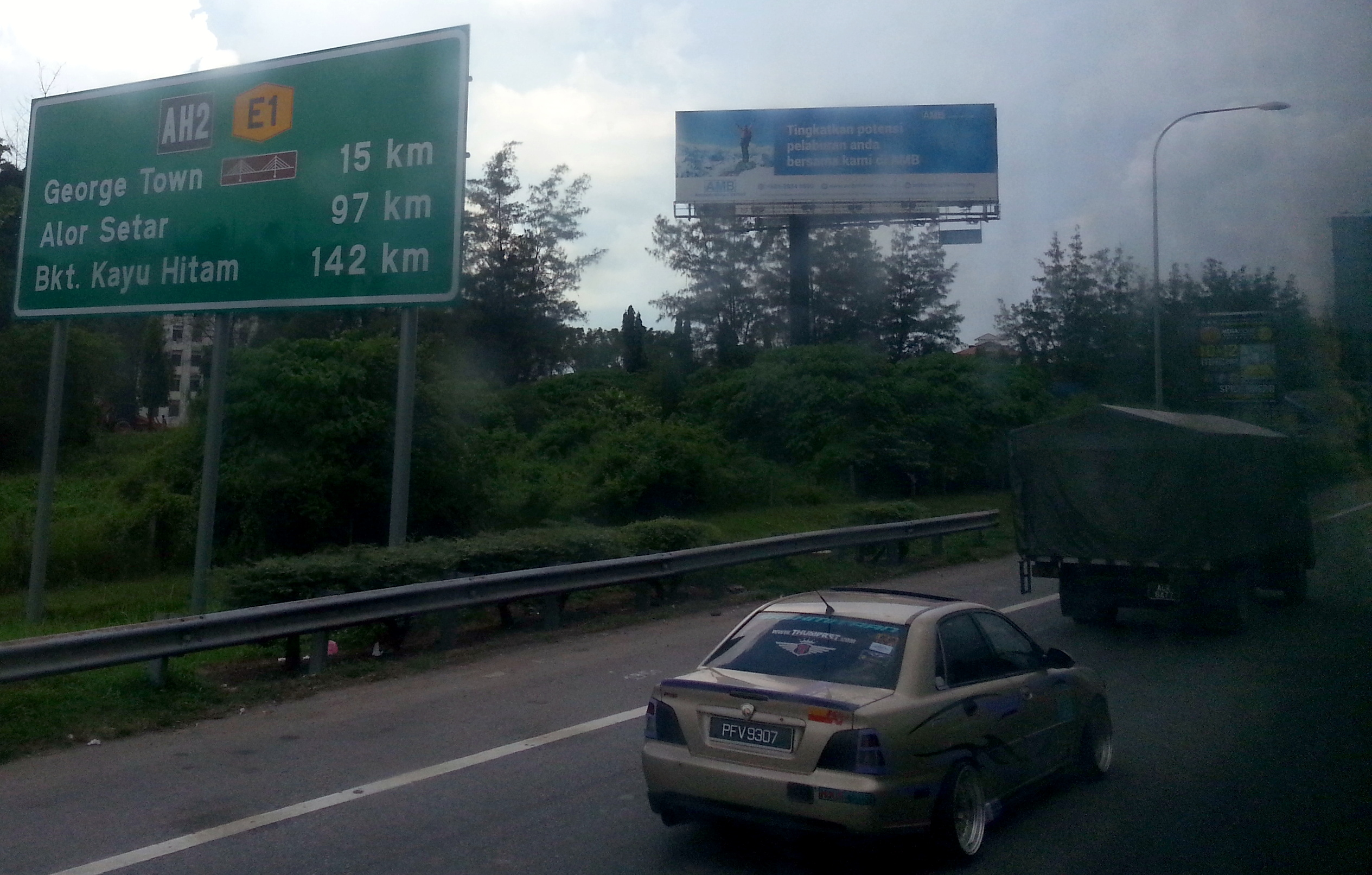
[[File:North-South Highway in Butterworth, Penang.jpg|thumb|A section of [[Malaysia]]'s [[North–South Expressway (Malaysia)|North-South Expressway]] in [[Penang]]. Note the [[AH2|Asian Highway 2]] signage.]] | [[File:North-South Highway in Butterworth, Penang.jpg|thumb|A section of [[Malaysia]]'s [[North–South Expressway (Malaysia)|North-South Expressway]] in [[Penang]]. Note the [[AH2|Asian Highway 2]] signage.]] | ||
[[File: | [[File:AH6-RUS.svg|thumb|right|Asian Highway route sign used on the [[AH6 (highway)|AH6]]]] | ||
The '''Asian Highway Network''' ('''AH'''), also known as the '''Great Asian Highway''', is a cooperative [[project]] among countries in Asia and the [[United Nations]] [[Economic and Social Commission for Asia and the Pacific]] (ESCAP) to improve their connectivity via [[highway]] systems. It is one of the three pillars of the Asian Land Transport Infrastructure Development (ALTID) project, endorsed by the ESCAP commission at its 48th session in 1992, comprising Asian Highway, [[Trans-Asian Railway]] (TAR) and facilitation of land transport projects. | The '''Asian Highway Network''' ('''AH'''), also known as the '''Great Asian Highway''', is a cooperative [[project]] among countries in Asia and the [[United Nations]] [[Economic and Social Commission for Asia and the Pacific]] (ESCAP) to improve their connectivity via [[highway]] systems. It is one of the three pillars of the Asian Land Transport Infrastructure Development (ALTID) project, endorsed by the ESCAP commission at its 48th session in 1992, comprising Asian Highway, [[Trans-Asian Railway]] (TAR) and facilitation of land transport projects. | ||
Agreements have been signed by 32 countries to allow the highway to cross the continent and also reach to Europe. Some of the countries taking part in the highway project are [[India]] ([[ | Agreements have been signed by 32 countries to allow the highway to cross the continent and also reach to Europe. Some of the countries taking part in the highway project are [[India]] ([[Act East policy]]), [[Sri Lanka]], [[Pakistan]], [[China]], [[Iran]], [[Japan]], [[South Korea]], [[NEPAL|Nepal]] and [[Bangladesh]].<ref name="Kamat" /> Most of the funding comes from the larger, more advanced Asian nations such as [[China]], [[South Korea]] and [[Singapore]] as well as international agencies such as the [[Asian Development Bank]] (ADB) and the [[Asian Infrastructure Investment Bank]] (AIIB). | ||
The project aims to make maximum use of the continent's existing highways to avoid the construction of newer ones, except in cases where missing routes necessitate their construction. ''Project Monitor'', an Asian infrastructure news website, has commented that "early beneficiaries of the Asian Highway project are the planners within the national land transport department of the participating countries [since] it assists them in planning the most cost-effective and efficient routes to promote domestic and international trade. Non-coastal areas, which are often negligible, are the other beneficiaries."<ref name="Kamat" /> | The project aims to make maximum use of the continent's existing highways to avoid the construction of newer ones, except in cases where missing routes necessitate their construction. ''Project Monitor'', an Asian infrastructure news website, has commented that "early beneficiaries of the Asian Highway project are the planners within the national land transport department of the participating countries [since] it assists them in planning the most cost-effective and efficient routes to promote domestic and international trade. Non-coastal areas, which are often negligible, are the other beneficiaries."<ref name="Kamat" /> | ||
However, in the mid-2000s some transportation experts | However, in the mid-2000s some transportation experts were skeptical about the viability of the project given the economic and political climate in both South and Southeast Asia.<ref name="Kamat" /> | ||
==History== | ==History== | ||
| Line 17: | Line 18: | ||
ESCAP has conducted several projects in cooperation with AH member countries step by step after the endorsement of ALTID in 1992. | ESCAP has conducted several projects in cooperation with AH member countries step by step after the endorsement of ALTID in 1992. | ||
The Intergovernmental Agreement on the Asian Highway Network (IGA) was adopted on November 18, 2003, by the Intergovernmental Meeting; the IGA includes Annex I, which identifies 55 AH routes among 32 member countries totalling approximately 140,000 km (87,500 miles), and Annex II "Classification and Design Standards". During the 60th session of the ESCAP Commission at [[Shanghai, China]], in April 2004, the IGA treaty was signed by 23 countries. By 2013, 29 countries had ratified the agreement.<ref>{{cite web|url=http://treaties.un.org/pages/ViewDetails.aspx?src%3DTREATY%26mtdsg_no%3DXI-B-34%26chapter%3D11%26lang%3Den |title=UNTC |access-date=2013-05-15 |url-status=dead |archive-url=https://web.archive.org/web/20140528133123/https://treaties.un.org/pages/ViewDetails.aspx?src=TREATY&mtdsg_no=XI-B-34&chapter=11&lang=en |archive-date=2014-05-28 }}.</ref> | The Intergovernmental Agreement on the Asian Highway Network (IGA) was adopted on February 28, 1997, by the Intergovernmental Meeting; 37000 kilometers,<ref>{{Cite web|url=https://www.doh.go.th/content/page/page/8103|title=กรมทางหลวง|website=www.doh.go.th}}</ref> and was adopted on November 18, 2003, by the Intergovernmental Meeting; the IGA includes Annex I, which identifies 55 AH routes among 32 member countries totalling approximately 140,000 km (87,500 miles), and Annex II "Classification and Design Standards". During the 60th session of the ESCAP Commission at [[Shanghai, China]], in April 2004, the IGA treaty was signed by 23 countries. By 2013, 29 countries had ratified the agreement.<ref>{{cite web|url=http://treaties.un.org/pages/ViewDetails.aspx?src%3DTREATY%26mtdsg_no%3DXI-B-34%26chapter%3D11%26lang%3Den |title=UNTC |access-date=2013-05-15 |url-status=dead |archive-url=https://web.archive.org/web/20140528133123/https://treaties.un.org/pages/ViewDetails.aspx?src=TREATY&mtdsg_no=XI-B-34&chapter=11&lang=en |archive-date=2014-05-28 }}.</ref> | ||
In 2007, British drivers [[Richard Meredith (author)|Richard Meredith]] and Phil Colley completed the first full East to West journey of the entire highway in an [[Aston Martin]] Vantage which was later sold to raise money for [[UNICEF]]. The drive was a marketing stunt promoted by the car manufacturer.<ref>''Milton Keynes Citizen'' 2008-11-03 "Aston adventure" Page 2</ref> | |||
==Implications== | ==Implications== | ||
The advanced highway network would provide for greater trade and social interactions between Asian countries, including personal contacts, project capitalizations, connections of major [[container terminal]]s with transportation points, and promotion of [[tourism]] via the new roadways.<ref name="Kamat">Kamat, Rahul [http://www.projectsmonitor.com/detailnews.asp?newsid=8609 The Great Asian Highway] {{webarchive|url=https://web.archive.org/web/20100117233246/http://projectsmonitor.com/detailnews.asp?newsid=8609 |date=2010-01-17 }}, Project Monitor website, 31 January 2005. Retrieved 2009-05-05</ref> | The advanced highway network would provide for greater trade and social interactions between Asian countries, including personal contacts, project capitalizations, connections of major [[container terminal]]s with transportation points, and promotion of [[tourism]] via the new roadways.<ref name="Kamat">Kamat, Rahul [http://www.projectsmonitor.com/detailnews.asp?newsid=8609 The Great Asian Highway] {{webarchive|url=https://web.archive.org/web/20100117233246/http://projectsmonitor.com/detailnews.asp?newsid=8609 |date=2010-01-17 }}, Project Monitor website, 31 January 2005. Retrieved 2009-05-05</ref> Infrastructure consultant Om Prakash noted that, "It's an excellent step taken by [[ESCAP]] to gather all the Asian countries under one crown but the problem with this project is political disputes between some countries, notably [[Pakistan]] and [[Myanmar]], which is delaying the project."<ref name="Kamat" />{{dubious|date=October 2019}} | ||
==Future development plans== | |||
Route AH1 is proposed to extend from [[Tokyo]] to the border with [[Bulgaria]] ([[EU]]) west of [[Istanbul]] and [[Edirne]], passing through both [[Korea]]s, China and other countries in Southeast, Central and [[South Asia]]. The corridor is expected to improve trade links between East Asian countries, [[India]] and [[Russia]]. To complete the route, existing roads will be upgraded and new roads constructed to link the network. {{US$|25 billion|link=yes}} has been spent or committed {{as of|2007|post=,}} with additional US$18 billion needed for upgrades and improvements to {{convert|26000|km|abbr=off}} of highway.<ref>[http://www.unescap.org/ttdw/common/tis/ah/priority_investment.asp#profiles "Priority Investment Needs for the Development for the Asian Highway Network"] {{webarchive |url=https://web.archive.org/web/20070720201050/http://www.unescap.org/ttdw/common/tis/ah/priority_investment.asp#profiles |date=July 20, 2007 }}, accessed July 14, 2007</ref> | |||
==Future | |||
Route AH1 is proposed to extend from [[Tokyo]] to the border with [[Bulgaria]] ([[EU]]) west of [[Istanbul]] and [[Edirne]], passing through both [[Korea]]s, China and other countries in Southeast, Central and [[South Asia]]. The corridor is expected to improve trade links between East Asian countries, [[India]] and [[Russia]]. To complete the route, existing roads will be upgraded and new roads constructed to link the network. US$25 billion has been spent or committed as of 2007, with additional US$18 billion needed for upgrades and improvements to | |||
==Numbering and signage== | ==Numbering and signage== | ||
| Line 33: | Line 32: | ||
The actual design of the signs has not been standardized, only that the letters and digits are in white or black, but the color, shape and size of the sign being completely flexible. Most examples feature a blue rectangular shield with a white inscription (similar to German [[Autobahn]] signage) with further examples of white on green and black on white rectangular shields.<ref name="Kamat"/><ref name="TCIGU"/><ref name="AsiaTimes">McCartan, Brian [https://web.archive.org/web/20080509061154/http://www.atimes.com/atimes/Southeast_Asia/JA23Ae01.html Roadblocks on the Great Asian Highway], Asia Times website, 23 January 2008. Retrieved 2009-05-05;</ref> | The actual design of the signs has not been standardized, only that the letters and digits are in white or black, but the color, shape and size of the sign being completely flexible. Most examples feature a blue rectangular shield with a white inscription (similar to German [[Autobahn]] signage) with further examples of white on green and black on white rectangular shields.<ref name="Kamat"/><ref name="TCIGU"/><ref name="AsiaTimes">McCartan, Brian [https://web.archive.org/web/20080509061154/http://www.atimes.com/atimes/Southeast_Asia/JA23Ae01.html Roadblocks on the Great Asian Highway], Asia Times website, 23 January 2008. Retrieved 2009-05-05;</ref> | ||
==Routes== | ==Routes== | ||
===AH1 to AH9: Continent-Wide Routes=== | ===AH1 to AH9: Continent-Wide Routes=== | ||
* [[File:Tabliczka AH1.svg|35px|link=AH1]] – {{convert|20557|km|mi|abbr=on}}: Tokyo, [[Japan]] – Bulgarian border, [[Turkey]]<ref name="treaty">https://treaties.un.org/doc/source/RecentTexts/XI_B_34_E.pdf | ** East-West, from S to N: 2, 1 intermixed, 5, 9, 6. | ||
** North-South, from E to W: 1 (along East China), 3, 4, 7, 8. | |||
* [[File:Tabliczka AH1.svg|35px|link=AH1]] – {{convert|20557|km|mi|abbr=on}}: Tokyo, [[Japan]] – Bulgarian border, [[Turkey]]<ref name="treaty">{{Cite web|url=https://treaties.un.org/doc/source/RecentTexts/XI_B_34_E.pdf|title=INTERGOVERNMENTAL AGREEMENT ON THE ASIAN HIGHWAY NETWORK}}</ref> [[Bulgaria]] – [[Kapıkule]] – [[Istanbul]] – [[Gerede]] – [[Ankara]] – [[Sivas]] – [[Refahiye]] – [[Aşkale]] – [[Doğubayazıt]] – [[Gürbulak]] – [[Bazargan, Iran|Bazargan]] – [[Ivughli]] – [[Tabriz]] – [[Qazvin]] – [[Tehran]] – [[Semnan, Iran|Semnan]] – [[Damghan]] – [[Sabzevar]] – [[Nishapur|Neishabour]]-[[Mashhad]] – [[Dowqarun]] –[[Islam Qala]] – [[Herat]] – [[Delaram]] – [[Kandahar]] – [[Kabul]] – [[Torkham border crossing|Torkham]] –[[Peshawar]] – [[Hassan Abdal]] – [[Rawalpindi]] – [[Islamabad]] – [[Lahore]] – [[Wagah]] – [[Attari]] – [[New Delhi]] – [[Agra]] – [[Kanpur]] – [[Varanasi]] – [[Sasaram]] –[[Gaya (India)|Gaya]]–[[Dhanbad]]– [[Kolkata]] – [[Petrapole]] – [[Benapole]] – [[Jessore|Jashore]] – [[Dhaka]] – [[Kachpur Union|Kachpur]] – [[Sylhet]] – [[Tamabil, Sylhet|Tamabil]] – [[Dawki]] – [[Shillong]] – [[Jorabat]] – [[Guwahati]] – [[Nagaon]] – [[Dimapur]] – [[Chümoukedima]] – [[Kohima]] – [[Viswema]] – [[Imphal]] – [[Moreh, India|Moreh]] – [[Tamu, Myanmar|Tamu]] – [[Mandalay]] – [[Meiktila]] – [[Payagyi]] – [[Yangon]] – [[Myawaddy]] – [[Mae Sot]] – [[Tak, Thailand|Tak]] – [[Nakhon Sawan]] – [[Bang Pa-in]] – [[Bangkok]] – [[Hin Kong]] – [[Kabin Buri]] – [[Aranyaprathet]] – [[Poipet]] – [[Phnom Penh]] – [[Bavet Municipality|Bavet]] – [[Mộc Bài]] – [[Ho Chi Minh City]] – [[Biên Hòa]] – [[Vũng Tàu]] – [[Nha Trang]] – [[Hội An]] – [[Da Nang]] – [[Huế]] – [[Đông Hà]] – [[Vinh]] – [[Hanoi]] – [[Đồng Đăng]] – [[Friendship Pass|Hữu Nghị]] –[[Friendship Pass|Youyiguan]] – [[Nanning]] – [[Guangzhou]] – [[Shenzhen]] – [[Hong Kong]] – [[Xiangtan]] – [[Changsha]] – [[Wuhan]] – [[Xinyang]] – [[Zhengzhou]] – [[Shijiazhuang]] – [[Beijing]] – [[Shenyang]] – [[Dandong]] – [[Sinuiju]] – [[Pyongyang]] – [[Kaesong]] – [[Munsan]] – [[Seoul]] – [[Daejeon]] – [[Daegu]] – [[Gyeongju]] – [[Busan]] – [[Fukuoka]] – [[Tokyo]] | |||
* [[File:Tabliczka AH2.svg|35px|link=AH2]] – {{convert|13177|km|mi|abbr=on}}: Denpasar, [[Indonesia]] – Khosravi, [[Iran]]<ref name="treaty" /> | * [[File:Tabliczka AH2.svg|35px|link=AH2]] – {{convert|13177|km|mi|abbr=on}}: Denpasar, [[Indonesia]] – Khosravi, [[Iran]]<ref name="treaty" /> | ||
** {{flagg|cxxlo|Iran}} [[Khosravi, Kermanshah|Khosravi]] – [[Hamadan]] – [[Saveh]] – [[Salafchegan]] (– [[Tehran]]) – [[Yazd]] – [[Anar, Iran|Anar]] – [[Kerman]] – [[Zahedan]] – [[Mirjaveh]] – | ** {{flagg|cxxlo|Iran}} [[Khosravi, Kermanshah|Khosravi]] – [[Hamadan]] – [[Saveh]] – [[Salafchegan]] (– [[Tehran]]) – [[Yazd]] – [[Anar, Iran|Anar]] – [[Kerman]] – [[Zahedan]] – [[Mirjaveh]] – | ||
| Line 79: | Line 44: | ||
** {{flagg|cxxlo|Nepal}} [[Bramhadev Mandi]] – [[Mahendranagar, Mahakali|Mahendranagar]] – [[Kohalpur]] – [[Narayangarh, Chitwan|Narayangarh]] – [[Pathlaiya]] – [[Kakarbhitta]] – | ** {{flagg|cxxlo|Nepal}} [[Bramhadev Mandi]] – [[Mahendranagar, Mahakali|Mahendranagar]] – [[Kohalpur]] – [[Narayangarh, Chitwan|Narayangarh]] – [[Pathlaiya]] – [[Kakarbhitta]] – | ||
** {{flagg|cxxlo|India}} [[Siliguri]] – | ** {{flagg|cxxlo|India}} [[Siliguri]] – | ||
** {{flagg|cxxlo|Bangladesh}} [[Banglabandha]]– [[Rangpur, Bangladesh|Rangpur]]– [[Hatikumrul]] – [[Dhaka]] – [[Kachpur Union|Kachpur]] – [[Sylhet]] – [[Tamabil]] – | ** {{flagg|cxxlo|Bangladesh}} [[Banglabandha]]– [[Rangpur, Bangladesh|Rangpur]]– [[Hatikumrul Interchange|Hatikumrul]] – [[Dhaka]] – [[Kachpur Union|Kachpur]] – [[Sylhet]] – [[Tamabil]] – | ||
** {{flagg|cxxlo|India}} [[Dawki]] – [[Shillong]] – [[Jorabat]] (– [[Guwahati]]) – [[Nagaon]] – [[Dimapur]] – [[Chümoukedima]] – [[Kohima]] – [[Viswema]] – [[Imphal]] – [[Moreh]] – | ** {{flagg|cxxlo|India}} [[Dawki]] – [[Shillong]] – [[Jorabat]] (– [[Guwahati]]) – [[Nagaon]] – [[Dimapur]] – [[Chümoukedima]] – [[Kohima]] – [[Viswema]] – [[Imphal]] – [[Moreh, India|Moreh]] – | ||
** {{flagg|cxxlo|Myanmar}} [[Tamu, Burma|Tamu]] – [[Mandalay]] – [[Meiktila]] – [[Kengtung]] – [[Tachilek]] – | ** {{flagg|cxxlo|Myanmar}} [[Tamu, Burma|Tamu]] – [[Mandalay]] – [[Meiktila]] – [[Kengtung]] – [[Tachilek]] – | ||
** {{flagg|cxxlo|Thailand}} [[Mae Sai]] – [[Chiang Rai]] – [[Tak (town)|Tak]] – [[Nakhon Sawan]] – [[Bang Pa-in District|Bang Pa-in]] – [[Bangkok]] – [[Hat Yai]] – [[Sadao District|Sadao]] – | ** {{flagg|cxxlo|Thailand}} [[Mae Sai]] – [[Chiang Rai]] – [[Tak (town)|Tak]] – [[Nakhon Sawan]] – [[Bang Pa-in District|Bang Pa-in]] – [[Bangkok]] – [[Hat Yai]] – [[Sadao District|Sadao]] – | ||
** {{flagg|cxxlo|Malaysia}} [[Bukit Kayu Hitam]] – [[Butterworth, Penang|Butterworth]] – [[Kuala Lumpur]] – [[Seremban]] – [[Johor Bahru]] – | ** {{flagg|cxxlo|Malaysia}} [[Bukit Kayu Hitam]] – [[Butterworth, Penang|Butterworth]] – [[Kuala Lumpur]] – [[Seremban]] – [[Johor Bahru]] – | ||
** {{flagg|cxxlo|Singapore}} [[Singapore]] – [[ | ** {{flagg|cxxlo|Singapore}} [[Singapore]] – [[Singapore]] | ||
** {{flagg|cxxlo|Indonesia}} [[Jakarta]] (– [[Merak, Banten|Merak]]) – [[Cikampek]] (– [[Bandung]]) – [[Semarang]] – [[Surakarta]] – [[Surabaya]] – [[Denpasar]] | ** {{flagg|cxxlo|Indonesia}} [[Jakarta]] (– [[Merak, Banten|Merak]]) – [[Cikampek]] (– [[Bandung]]) – [[Semarang]] – [[Surakarta]] – [[Surabaya]] – [[Denpasar]] | ||
* [[File:Tabliczka AH3.svg|35px|link=AH3]] – {{convert|7331|km|mi|abbr=on}}: | * [[File:Tabliczka AH3.svg|35px|link=AH3]] – {{convert|7331|km|mi|abbr=on}}: | ||
| Line 97: | Line 62: | ||
* [[File:Tabliczka AH4.svg|35px|link=AH4]] – {{convert|6024|km|mi|abbr=on}}: Novosibirsk, [[Russia]] – Karachi, [[Pakistan]]<ref name="treaty" /> | * [[File:Tabliczka AH4.svg|35px|link=AH4]] – {{convert|6024|km|mi|abbr=on}}: Novosibirsk, [[Russia]] – Karachi, [[Pakistan]]<ref name="treaty" /> | ||
** {{flagg|cxxlo|Russia}} [[Novosibirsk]] – [[Barnaul]] – [[Tashanta]] – | ** {{flagg|cxxlo|Russia}} [[Novosibirsk]] – [[Barnaul]] – [[Tashanta]] – | ||
** {{flagg|cxxlo|Mongolia}} [[Ulaanbaishint]] – [[Khovd (city)|Khovd]] – [[Yarantai]] | ** {{flagg|cxxlo|Mongolia}} [[Ulaanbaishint]] – [[Ölgii (city)|Ölgii]] – [[Khovd (city)|Khovd]] – [[Yarantai]] | ||
** {{flagg|cxxlo|China}} [[Ürümqi]] – [[Kashgar]] – [[Honqiraf]] – | ** {{flagg|cxxlo|China}} [[Ürümqi]] – [[Kashgar]] – [[Honqiraf]] – | ||
** {{flagg|cxxlo|Pakistan}} [[Khunjerab Pass|Khunjerab]] – [[Hassanabdal]] – [[Rawalpindi]] – [[Islamabad]] – [[Lahore]] – [[Multan]] – [[Rohri]] – [[Hyderabad, Sindh|Hyderabad]] – [[Karachi]] | ** {{flagg|cxxlo|Pakistan}} [[Khunjerab Pass|Khunjerab]] – [[Hassanabdal]] – [[Rawalpindi]] – [[Islamabad]] – [[Lahore]] – [[Multan]] – [[Rohri]] – [[Hyderabad, Sindh|Hyderabad]] – [[Karachi]] | ||
| Line 103: | Line 68: | ||
**{{flagg|cxxlo|Turkey}} Border of [[Bulgaria]] – [[Kapikule]] – [[Istanbul]] – [[Gerede]] – [[Merzifon]] – [[Samsun]] – [[Trabzon]] – [[Sarp]] – | **{{flagg|cxxlo|Turkey}} Border of [[Bulgaria]] – [[Kapikule]] – [[Istanbul]] – [[Gerede]] – [[Merzifon]] – [[Samsun]] – [[Trabzon]] – [[Sarp]] – | ||
** {{flagg|cxxlo|Georgia}} [[Batumi]] – [[Poti]] – [[Senaki]] – (Port of [[Anaklia]] – [[Zugdidi]] bypass road – [[Samtredia]]) [[Khashuri]] – [[Mtskheta]] – [[Tbilisi]] – | ** {{flagg|cxxlo|Georgia}} [[Batumi]] – [[Poti]] – [[Senaki]] – (Port of [[Anaklia]] – [[Zugdidi]] bypass road – [[Samtredia]]) [[Khashuri]] – [[Mtskheta]] – [[Tbilisi]] – | ||
** {{flagg|cxxlo|Azerbaijan}} [[Red Bridge (border)|Red Bridge]] – [[Qazax]] – [[Ganja, Azerbaijan|Ganja]] – [[Gazi Mammed]] – [[Ələt|Alat]] – [[Baku]] | ** {{flagg|cxxlo|Azerbaijan}} [[Red Bridge (border)|Red Bridge]] – [[Qazax]] – [[Ganja, Azerbaijan|Ganja]] – [[Gazi Mammed]] – [[Ələt|Alat]] – [[Baku]] ... | ||
** {{flagg|cxxlo|Turkmenistan}} [[Türkmenbaşy, Turkmenistan|Turkmenbashi]] – [[Serdar (city)|Serdar]] – [[Ashgabat]] – [[Tejen]] – [[Mary, Turkmenistan|Mary]] – [[Turkmenabat]] – [[Farap]] – | ** {{flagg|cxxlo|Turkmenistan}} [[Türkmenbaşy, Turkmenistan|Turkmenbashi]] – [[Serdar (city)|Serdar]] – [[Ashgabat]] – [[Tejen]] – [[Mary, Turkmenistan|Mary]] – [[Turkmenabat]] – [[Farap]] – | ||
**{{flagg|cxxlo|Uzbekistan}} [[ | **{{flagg|cxxlo|Uzbekistan}} [[Olot, Uzbekistan|Olot]] – [[Bukhara]] – [[Navoi]] – [[Samarkand]] – [[Syrdaria]] – [[Tashkent]] – [[Chernyavka]] – | ||
** {{flagg|cxxlo|Kazakhstan}} [[Chernyaevka]] – [[Shymkent]] – [[Merki]] – | ** {{flagg|cxxlo|Kazakhstan}} [[Chernyaevka]] – [[Shymkent]] – [[Merki]] – | ||
** {{flagg|cxxlo|Kyrgyzstan}} [[Chaldovar]] – [[Kara Balta]] – [[Bishkek]] – | ** {{flagg|cxxlo|Kyrgyzstan}} [[Chaldovar]] – [[Kara Balta]] – [[Bishkek]] – | ||
| Line 111: | Line 76: | ||
** {{flagg|cxxlo|China}} [[Khorgas]] – [[Jinghe County|Jinghe]] – [[Kuytun]] – [[Ürümqi]] – [[Turpan]] – [[Lanzhou]] – [[Xi'an]] – [[Xinyang]] – [[Nanjing]] – [[Shanghai]] | ** {{flagg|cxxlo|China}} [[Khorgas]] – [[Jinghe County|Jinghe]] – [[Kuytun]] – [[Ürümqi]] – [[Turpan]] – [[Lanzhou]] – [[Xi'an]] – [[Xinyang]] – [[Nanjing]] – [[Shanghai]] | ||
* [[File:Tabliczka AH6.svg|35px|link=AH6 (highway)]] – {{convert|10475|km|mi|abbr=on}}: Busan, [[South Korea]] – Belarusian border, [[Russia]]<ref name="treaty" /> | * [[File:Tabliczka AH6.svg|35px|link=AH6 (highway)]] – {{convert|10475|km|mi|abbr=on}}: Busan, [[South Korea]] – Belarusian border, [[Russia]]<ref name="treaty" /> | ||
** {{flagg|cxxlo|Russia}} Border of [[Belarus]] – [[Krasnoye, Krasninsky District, Smolensk Oblast|Krasnoye]] – [[Moscow]] – [[Samara]] – [[Ufa]] – [[Chelyabinsk]] – [[Petukhovo]] – | ** {{flagg|cxxlo|Russia}} Border of [[Belarus]] – [[Krasnoye, Krasninsky District, Smolensk Oblast|Krasnoye]] – [[Moscow]] – [[Samara]] – [[Ufa]] – [[Chelyabinsk]] – [[Petukhovo (town), Kurgan Oblast|Petukhovo]] – | ||
** {{flagg|cxxlo|Kazakhstan}} [[Chistoe]] – [[Petropavl]] – [[Karakoga]] – | ** {{flagg|cxxlo|Kazakhstan}} [[Chistoe]] – [[Petropavl]] – [[Karakoga]] – | ||
** {{flagg|cxxlo|Russia}} [[Isilkul]] – [[Omsk]] – [[Novosibirsk]] – [[Krasnoyarsk]] – [[Irkutsk]] – [[Ulan-Ude]] – [[Chita, Zabaykalsky Krai|Chita]] – [[Zabaykalsk]] – | ** {{flagg|cxxlo|Russia}} [[Isilkul]] – [[Omsk]] – [[Novosibirsk]] – [[Krasnoyarsk]] – [[Irkutsk]] – [[Ulan-Ude]] – [[Chita, Zabaykalsky Krai|Chita]] – [[Zabaykalsk]] – | ||
| Line 117: | Line 82: | ||
** {{flagg|cxxlo|Russia}} [[Pogranichny]] – [[Ussuriysk]] – [[Razdolnoye, Primorsky Krai|Razdolnoye]] (– [[Vladivostok]] – [[Nahodka]]) – [[Khasan (urban-type settlement)|Khasan]] – | ** {{flagg|cxxlo|Russia}} [[Pogranichny]] – [[Ussuriysk]] – [[Razdolnoye, Primorsky Krai|Razdolnoye]] (– [[Vladivostok]] – [[Nahodka]]) – [[Khasan (urban-type settlement)|Khasan]] – | ||
** {{flagg|cxxlo|North Korea}} [[Sonbong]] – [[Chongjin]] – [[Wonsan]] (– [[Pyongyang]]) – | ** {{flagg|cxxlo|North Korea}} [[Sonbong]] – [[Chongjin]] – [[Wonsan]] (– [[Pyongyang]]) – | ||
** {{flagg|cxxlo|South Korea}} [[Goseong County, Gangwon|Goseong]] – [[ | ** {{flagg|cxxlo|South Korea}} [[Goseong County, Gangwon|Goseong]] – [[Ganseong]] – [[Gangneung]] – [[Gyeongju]] – [[Busan]] | ||
* [[File:Tabliczka AH7.svg|35px|link=AH7]] – {{convert|5868|km|mi|abbr=on}}: Yekaterinburg, [[Russia]] – Karachi, [[Pakistan]]<ref name="treaty" /> | * [[File:Tabliczka AH7.svg|35px|link=AH7]] – {{convert|5868|km|mi|abbr=on}}: Yekaterinburg, [[Russia]] – Karachi, [[Pakistan]]<ref name="treaty" /> | ||
** {{flagg|cxxlo|Russia}} [[Yekaterinburg]] – [[Chelyabinsk]] – [[Troisk]] – | ** {{flagg|cxxlo|Russia}} [[Yekaterinburg]] – [[Chelyabinsk]] – [[Troisk]] – | ||
| Line 144: | Line 109: | ||
** {{flagg|cxxlo|Thailand}} [[Nong Khai]] – [[Udon Thani]] – [[Khon Kaen]] – [[Nakhon Ratchasima]] – [[Hin Kong]] | ** {{flagg|cxxlo|Thailand}} [[Nong Khai]] – [[Udon Thani]] – [[Khon Kaen]] – [[Nakhon Ratchasima]] – [[Hin Kong]] | ||
* [[File:Tabliczka AH13.svg|35px|link=AH13]] – {{convert|1429|km|mi|abbr=on}}: Hanoi, [[Vietnam]] – Nakhon Sawen, [[Thailand]]<ref name="treaty" /> | * [[File:Tabliczka AH13.svg|35px|link=AH13]] – {{convert|1429|km|mi|abbr=on}}: Hanoi, [[Vietnam]] – Nakhon Sawen, [[Thailand]]<ref name="treaty" /> | ||
** {{flagg|cxxlo|Vietnam}} [[Hanoi]] – [[Hòa Bình City|Hoa Binh]] – [[Son La]] – [[Dien Bien]] – [[ | ** {{flagg|cxxlo|Vietnam}} [[Hanoi]] – [[Hòa Bình City|Hoa Binh]] – [[Son La]] – [[Dien Bien]] – [[Tây Trang]] – | ||
** {{flagg|cxxlo|Laos}} [[Pang Hok]] – [[Muang Khoua]] – [[Oudomxai]] – [[Muang Ngeun]] – | ** {{flagg|cxxlo|Laos}} [[Pang Hok]] – [[Muang Khoua]] – [[Oudomxai]] – [[Muang Ngeun]] – | ||
** {{flagg|cxxlo|Thailand}} [[Huai Kon]] – [[Uttaradit]] – [[Phitsanulok]] – [[Nakhon Sawan]] | ** {{flagg|cxxlo|Thailand}} [[Huai Kon]] – [[Uttaradit]] – [[Phitsanulok]] – [[Nakhon Sawan]] | ||
| Line 170: | Line 135: | ||
** {{flagg|cxxlo|Cambodia}} [[O Yadav]] – [[Banlung]] – [[Stung Treng]] – [[Preah Vihear (town)|Preah Vihear]] – [[Siem Reap]] – [[Serei Saophoan (city)|Serei Saophoan]] | ** {{flagg|cxxlo|Cambodia}} [[O Yadav]] – [[Banlung]] – [[Stung Treng]] – [[Preah Vihear (town)|Preah Vihear]] – [[Siem Reap]] – [[Serei Saophoan (city)|Serei Saophoan]] | ||
* [[File:Tabliczka AH25.svg|35px|link=AH25]] [[Trans-Sumatran Highway]] (Eastern Route) – {{convert|2549|km|mi|abbr=on}}: Banda Aceh, [[Indonesia]] – Merak, [[Indonesia]]<ref name="treaty" /> | * [[File:Tabliczka AH25.svg|35px|link=AH25]] [[Trans-Sumatran Highway]] (Eastern Route) – {{convert|2549|km|mi|abbr=on}}: Banda Aceh, [[Indonesia]] – Merak, [[Indonesia]]<ref name="treaty" /> | ||
** {{flagg|cxxlo|Indonesia}} [[Banda Aceh]] – [[Medan]] – [[Tebingtinggi]] – [[Dumai]] – [[Pekanbaru]] – [[Jambi]] – [[Palembang]] – [[Tanjung Karang, Lampung|Tanjung Karang]] – [[Bakauheni]] | ** {{flagg|cxxlo|Indonesia}} [[Banda Aceh]] – [[Medan]] – [[Tebingtinggi]] – [[Dumai]] – [[Pekanbaru]] – [[Jambi]] – [[Palembang]] – [[Tanjung Karang, Lampung|Tanjung Karang]] – [[Bakauheni]] ... [[Merak, Banten|Merak]] | ||
* [[File:Tabliczka AH26.svg|35px|link=AH26]] [[Pan-Philippine Highway]] – {{convert|3379.73|km|mi|abbr=on}}:<ref name="slides">{{cite web|url=https://www.unescap.org/sites/default/files/Philippines_0.pdf|title=Asian Highway 26 (AH26)|publisher=Department of Public Works and Highways|first=Maria Catalina|last=Cabral|website=ESCAP|access-date=September 4, 2021}}</ref> Laoag, [[Philippines]] – Zamboanga, [[Philippines]]<ref name="treaty" /> | * [[File:Tabliczka AH26.svg|35px|link=AH26]] [[Pan-Philippine Highway]] – {{convert|3379.73|km|mi|abbr=on}}:<ref name="slides">{{cite web|url=https://www.unescap.org/sites/default/files/Philippines_0.pdf|title=Asian Highway 26 (AH26)|publisher=Department of Public Works and Highways|first=Maria Catalina|last=Cabral|website=ESCAP|access-date=September 4, 2021}}</ref> Laoag, [[Philippines]] – Zamboanga, [[Philippines]]<ref name="treaty" /> | ||
** {{flagg|cxxlo|Philippines}} [[Laoag]] – [[Tuguegarao]] – [[Guiguinto]] – [[Quezon City]] (– [[Manila]] – [[Makati]]) – Makati – [[Calamba, Laguna|Calamba]] – [[Legazpi, Albay|Legazpi]] – [[Matnog]] | ** {{flagg|cxxlo|Philippines}} [[Laoag]] – [[Tuguegarao]] – [[Guiguinto]] – [[Quezon City]] (– [[Manila]] – [[Makati]]) – Makati – [[Calamba, Laguna|Calamba]] – [[Legazpi, Albay|Legazpi]] – [[Matnog]] ... [[Allen, Northern Samar|Allen]] – [[Tacloban]] (– [[Ormoc City]] ... [[Cebu City]]) – [[Liloan, Southern Leyte|Liloan]] ... [[Surigao City|Surigao]] – [[Butuan]] – [[Davao City|Davao]] (– [[Cagayan de Oro]]) – [[General Santos]] – [[Cotabato City]] – [[Zamboanga City|Zamboanga]] | ||
===AH30 to AH39: East Asia and Northeast Asia Routes=== | ===AH30 to AH39: East Asia and Northeast Asia Routes=== | ||
| Line 249: | Line 214: | ||
|2,030 km (1269 miles) | |2,030 km (1269 miles) | ||
|[[Kolkata]], [[India]] | |[[Kolkata]], [[India]] | ||
|[[Chennai]], [[Tamil Nadu|TN]], [[India]] | |[[Krishnagiri]], [[Tamil Nadu|TN]], [[India|IN]] (Via) [[Chennai]], [[Tamil Nadu|TN]], [[India]] | ||
|- | |- | ||
|[[AH46]] | |[[AH46]] | ||
| Line 379: | Line 344: | ||
|[[İçel]], [[Turkey]] | |[[İçel]], [[Turkey]] | ||
|- | |- | ||
| | |AH85 | ||
|338 km (211 miles) | |338 km (211 miles) | ||
|[[Refahiye]], Turkey (on AH1) | |[[Refahiye]], Turkey (on AH1) | ||
| Line 432: | Line 397: | ||
|Dawei, [[Myanmar]] | |Dawei, [[Myanmar]] | ||
|[[Pak Tho District|Pak Tho]] on AH2 in [[Thailand]] | |[[Pak Tho District|Pak Tho]] on AH2 in [[Thailand]] | ||
|<ref name="ah-db"/><ref>{{Cite book|title=Master plan on ASEAN connectivity, 2025.|year=2016|isbn=9786026392022|location=Jakarta|oclc=970396295|url=http://asean.org/storage/2016/09/Master-Plan-on-ASEAN-Connectivity-20251.pdf|access-date=2018-01-12}}</ref> | |<ref name="ah-db"/><ref>{{Cite book|title=Master plan on ASEAN connectivity, 2025.|year=2016|isbn=9786026392022|location=Jakarta|oclc=970396295|url=http://asean.org/storage/2016/09/Master-Plan-on-ASEAN-Connectivity-20251.pdf|access-date=2018-01-12|archive-date=2021-05-13|archive-url=https://web.archive.org/web/20210513055943/https://asean.org/storage/2016/09/Master-Plan-on-ASEAN-Connectivity-20251.pdf|url-status=dead}}</ref> | ||
|- | |- | ||
|[[AH131]] | |[[AH131]] | ||
| Line 453: | Line 418: | ||
|- | |- | ||
|[[AH141]] | |[[AH141]] | ||
| | | {{convert|272|km|abbr=on}} | ||
|[[Port Klang]] [[Malaysia]] | |[[Port Klang]] [[Malaysia]] | ||
|[[Kuantan]], [[Malaysia]] | |[[Kuantan]], [[Malaysia]] | ||
| Line 459: | Line 424: | ||
|- | |- | ||
|[[AH142]] | |[[AH142]] | ||
| | | {{convert|200|km|abbr=on}} | ||
|[[Yong Peng]], [[Malaysia]] | |[[Yong Peng]], [[Malaysia]] | ||
|[[Gambang, Pahang|Gambang]], [[Malaysia]] | |[[Gambang, Pahang|Gambang]], [[Malaysia]] | ||
| Line 465: | Line 430: | ||
|- | |- | ||
|[[AH143]] | |[[AH143]] | ||
| | | {{convert|28|km|abbr=on}} | ||
|[[Sengkang]], [[Singapore]] | |[[Sengkang]], [[Singapore]] | ||
|[[Senai]], [[Malaysia]] | |[[Senai]], [[Malaysia]] | ||
| Line 471: | Line 436: | ||
|- | |- | ||
|[[Pan-Borneo Highway|AH150]] | |[[Pan-Borneo Highway|AH150]] | ||
| | | {{convert|2083|km|abbr=on}} | ||
| | |Telok Melano, [[Sarawak]] | ||
|[[Entikong]], [[West Kalimantan]] | |[[Entikong]], [[West Kalimantan]] | ||
|Also known as the [[Pan-Borneo Highway]] | |Also known as the [[Pan-Borneo Highway]] | ||
| Line 480: | Line 445: | ||
|[[Tebing Tinggi]], [[North Sumatra]] | |[[Tebing Tinggi]], [[North Sumatra]] | ||
|[[Bandar Lampung]], [[Lampung]] | |[[Bandar Lampung]], [[Lampung]] | ||
|Also known as the [[Trans-Sumatran Highway|Central Trans-Sumatran Highway]]. The highway is also co-signed as [[File:Nasional5. | |Also known as the [[Trans-Sumatran Highway|Central Trans-Sumatran Highway]]. The highway is also co-signed as [[File:ID Nasional5.svg|alt=|20x20px]] [[Sumatra]] by the [[Ministry of Transportation (Indonesia)]] since 2019. | ||
|- | |- | ||
|[[AH152]] | |[[AH152]] | ||
| Line 486: | Line 451: | ||
|[[Jakarta]] | |[[Jakarta]] | ||
|[[Surakarta]], [[Central Java]] | |[[Surakarta]], [[Central Java]] | ||
|The highway is also co-signed by some Indonesian National Route [[File:Nasional6. | |The highway is also co-signed by some Indonesian National Route [[File:ID Nasional6.svg|alt=|20x20px]] [[File:ID Nasional9.svg|alt=|20x20px]] [[File:ID Nasional11.svg|alt=|20x20px]] [[File:ID Nasional13.svg|alt=|20x20px]] [[File:ID Nasional15.svg|alt=|20x20px]] [[Java]] by the [[Ministry of Transportation (Indonesia)]] since 2019. | ||
|} | |} | ||
| Line 579: | Line 544: | ||
==External links== | ==External links== | ||
* [http://www.unescap.org/our-work/transport/asian-highway The project homepage] | * [http://www.unescap.org/our-work/transport/asian-highway The project homepage] {{Webarchive|url=https://web.archive.org/web/20150104022733/http://www.unescap.org/our-work/transport/asian-highway |date=2015-01-04 }} | ||
** [https://www.unescap.org/our-work/transport/asian-highway-network Alternative link] | ** [https://www.unescap.org/our-work/transport/asian-highway-network Alternative link] | ||
* [https://treaties.un.org/doc/source/RecentTexts/XI_B_34_E.pdf Intergovernmental Agreement on the Asian Highway Network] | * [https://treaties.un.org/doc/source/RecentTexts/XI_B_34_E.pdf Intergovernmental Agreement on the Asian Highway Network] | ||
* [ | * [https://news.bbc.co.uk/2/hi/asia-pacific/3660467.stm Asia signs up to 'new Silk Road'] BBC News report (April 26, 2004) | ||
* [https://web.archive.org/web/20050415104142/http://www.unescap.org/unis/press/2004/apr/g09.asp UNESCAP press release announcing treaty] | * [https://web.archive.org/web/20050415104142/http://www.unescap.org/unis/press/2004/apr/g09.asp UNESCAP press release announcing treaty] | ||
* [http://www.unescap.org/resources/asian-highway-handbook 2003 Asian Highway Handbook] | * [http://www.unescap.org/resources/asian-highway-handbook 2003 Asian Highway Handbook] | ||
* [https://web.archive.org/web/20070928041405/http://pakistantimes.net/top030210601.htm Pakistan's Gwadar to Afghanistan, China road declared Asian Highway] | * {{usurped|1=[https://web.archive.org/web/20070928041405/http://pakistantimes.net/top030210601.htm Pakistan's Gwadar to Afghanistan, China road declared Asian Highway]}} | ||
* [http://www.driventogether.co.uk/ Driven Together, Historic first crossing of Asia's new Highway to the West] | * [http://www.driventogether.co.uk/ Driven Together, Historic first crossing of Asia's new Highway to the West] | ||
* [http://www.roadtraffic-technology.com/projects/asian-highway-network/ Asian Highway Network Details] | * [http://www.roadtraffic-technology.com/projects/asian-highway-network/ Asian Highway Network Details] | ||
Latest revision as of 16:43, 25 March 2026


The Asian Highway Network (AH), also known as the Great Asian Highway, is a cooperative project among countries in Asia and the United Nations Economic and Social Commission for Asia and the Pacific (ESCAP) to improve their connectivity via highway systems. It is one of the three pillars of the Asian Land Transport Infrastructure Development (ALTID) project, endorsed by the ESCAP commission at its 48th session in 1992, comprising Asian Highway, Trans-Asian Railway (TAR) and facilitation of land transport projects.
Agreements have been signed by 32 countries to allow the highway to cross the continent and also reach to Europe. Some of the countries taking part in the highway project are India (Act East policy), Sri Lanka, Pakistan, China, Iran, Japan, South Korea, Nepal and Bangladesh.[1] Most of the funding comes from the larger, more advanced Asian nations such as China, South Korea and Singapore as well as international agencies such as the Asian Development Bank (ADB) and the Asian Infrastructure Investment Bank (AIIB).
The project aims to make maximum use of the continent's existing highways to avoid the construction of newer ones, except in cases where missing routes necessitate their construction. Project Monitor, an Asian infrastructure news website, has commented that "early beneficiaries of the Asian Highway project are the planners within the national land transport department of the participating countries [since] it assists them in planning the most cost-effective and efficient routes to promote domestic and international trade. Non-coastal areas, which are often negligible, are the other beneficiaries."[1]
However, in the mid-2000s some transportation experts were skeptical about the viability of the project given the economic and political climate in both South and Southeast Asia.[1]
History[edit | edit source]
The AH project was initiated by the United Nations in 1959 with the aim of promoting the development of international road transport in the region. During the first phase of the project (1960–1970) considerable progress was achieved, however, progress slowed down when financial assistance was suspended in 1975.
ESCAP has conducted several projects in cooperation with AH member countries step by step after the endorsement of ALTID in 1992.
The Intergovernmental Agreement on the Asian Highway Network (IGA) was adopted on February 28, 1997, by the Intergovernmental Meeting; 37000 kilometers,[2] and was adopted on November 18, 2003, by the Intergovernmental Meeting; the IGA includes Annex I, which identifies 55 AH routes among 32 member countries totalling approximately 140,000 km (87,500 miles), and Annex II "Classification and Design Standards". During the 60th session of the ESCAP Commission at Shanghai, China, in April 2004, the IGA treaty was signed by 23 countries. By 2013, 29 countries had ratified the agreement.[3]
In 2007, British drivers Richard Meredith and Phil Colley completed the first full East to West journey of the entire highway in an Aston Martin Vantage which was later sold to raise money for UNICEF. The drive was a marketing stunt promoted by the car manufacturer.[4]
Implications[edit | edit source]
The advanced highway network would provide for greater trade and social interactions between Asian countries, including personal contacts, project capitalizations, connections of major container terminals with transportation points, and promotion of tourism via the new roadways.[1] Infrastructure consultant Om Prakash noted that, "It's an excellent step taken by ESCAP to gather all the Asian countries under one crown but the problem with this project is political disputes between some countries, notably Pakistan and Myanmar, which is delaying the project."[1][dubious ]
Future development plans[edit | edit source]
Route AH1 is proposed to extend from Tokyo to the border with Bulgaria (EU) west of Istanbul and Edirne, passing through both Koreas, China and other countries in Southeast, Central and South Asia. The corridor is expected to improve trade links between East Asian countries, India and Russia. To complete the route, existing roads will be upgraded and new roads constructed to link the network. US$25 billion has been spent or committed As of 2007,[update] with additional US$18 billion needed for upgrades and improvements to 26,000 kilometres (16,000 miles) of highway.[5]
Numbering and signage[edit | edit source]
The project new highway route numbers begin with "AH", standing for "Asian Highway", followed by one, two or three digits.[6] Single-digit route numbers from 1 to 9 are assigned to major Asian Highway routes which cross more than one subregion.[6] Two- and three-digit route numbers are assigned to indicate the routes within subregions, including those connecting to neighbouring subregions, and self-contained highway routes within the participating countries.[6] Route numbers are printed in the Latin script and Hindu-Arabic numerals and may simply be added to existing signage, like the E-road network.[6]
The actual design of the signs has not been standardized, only that the letters and digits are in white or black, but the color, shape and size of the sign being completely flexible. Most examples feature a blue rectangular shield with a white inscription (similar to German Autobahn signage) with further examples of white on green and black on white rectangular shields.[1][6][7]
Routes[edit | edit source]
AH1 to AH9: Continent-Wide Routes[edit | edit source]
- East-West, from S to N: 2, 1 intermixed, 5, 9, 6.
- North-South, from E to W: 1 (along East China), 3, 4, 7, 8.
 – 20,557 km (12,774 mi): Tokyo, Japan – Bulgarian border, Turkey[8] Bulgaria – Kapıkule – Istanbul – Gerede – Ankara – Sivas – Refahiye – Aşkale – Doğubayazıt – Gürbulak – Bazargan – Ivughli – Tabriz – Qazvin – Tehran – Semnan – Damghan – Sabzevar – Neishabour-Mashhad – Dowqarun –Islam Qala – Herat – Delaram – Kandahar – Kabul – Torkham –Peshawar – Hassan Abdal – Rawalpindi – Islamabad – Lahore – Wagah – Attari – New Delhi – Agra – Kanpur – Varanasi – Sasaram –Gaya–Dhanbad– Kolkata – Petrapole – Benapole – Jashore – Dhaka – Kachpur – Sylhet – Tamabil – Dawki – Shillong – Jorabat – Guwahati – Nagaon – Dimapur – Chümoukedima – Kohima – Viswema – Imphal – Moreh – Tamu – Mandalay – Meiktila – Payagyi – Yangon – Myawaddy – Mae Sot – Tak – Nakhon Sawan – Bang Pa-in – Bangkok – Hin Kong – Kabin Buri – Aranyaprathet – Poipet – Phnom Penh – Bavet – Mộc Bài – Ho Chi Minh City – Biên Hòa – Vũng Tàu – Nha Trang – Hội An – Da Nang – Huế – Đông Hà – Vinh – Hanoi – Đồng Đăng – Hữu Nghị –Youyiguan – Nanning – Guangzhou – Shenzhen – Hong Kong – Xiangtan – Changsha – Wuhan – Xinyang – Zhengzhou – Shijiazhuang – Beijing – Shenyang – Dandong – Sinuiju – Pyongyang – Kaesong – Munsan – Seoul – Daejeon – Daegu – Gyeongju – Busan – Fukuoka – Tokyo
 – 13,177 km (8,188 mi): Denpasar, Indonesia – Khosravi, Iran[8]
 Khosravi – Hamadan – Saveh – Salafchegan (– Tehran) – Yazd – Anar – Kerman – Zahedan – Mirjaveh –
 Taftan – Quetta – Rohri – Multan – Lahore – Wagah –
 Attari – New Delhi – Rampur – Banbasa –
 Bramhadev Mandi – Mahendranagar – Kohalpur – Narayangarh – Pathlaiya – Kakarbhitta –
- Siliguri –
 Banglabandha– Rangpur– Hatikumrul – Dhaka – Kachpur – Sylhet – Tamabil –
- Dawki – Shillong – Jorabat (– Guwahati) – Nagaon – Dimapur – Chümoukedima – Kohima – Viswema – Imphal – Moreh –
 Tamu – Mandalay – Meiktila – Kengtung – Tachilek –
 Mae Sai – Chiang Rai – Tak – Nakhon Sawan – Bang Pa-in – Bangkok – Hat Yai – Sadao –
 Bukit Kayu Hitam – Butterworth – Kuala Lumpur – Seremban – Johor Bahru –
 Singapore – Singapore
 Jakarta (– Merak) – Cikampek (– Bandung) – Semarang – Surakarta – Surabaya – Denpasar
 – 7,331 km (4,555 mi):
 – 6,024 km (3,743 mi): Novosibirsk, Russia – Karachi, Pakistan[8]
 Novosibirsk – Barnaul – Tashanta –
 Ulaanbaishint – Ölgii – Khovd – Yarantai
 Ürümqi – Kashgar – Honqiraf –
- Khunjerab – Hassanabdal – Rawalpindi – Islamabad – Lahore – Multan – Rohri – Hyderabad – Karachi
 – 10,380 km (6,450 mi): Shanghai, China – Bulgarian border, Turkey[9]
 Border of Bulgaria – Kapikule – Istanbul – Gerede – Merzifon – Samsun – Trabzon – Sarp –
 Batumi – Poti – Senaki – (Port of Anaklia – Zugdidi bypass road – Samtredia) Khashuri – Mtskheta – Tbilisi –
 Red Bridge – Qazax – Ganja – Gazi Mammed – Alat – Baku ...
 Turkmenbashi – Serdar – Ashgabat – Tejen – Mary – Turkmenabat – Farap –
 Olot – Bukhara – Navoi – Samarkand – Syrdaria – Tashkent – Chernyavka –
 Chernyaevka – Shymkent – Merki –
 Chaldovar – Kara Balta – Bishkek –
- Kordai – Kaskelen – Almaty –
- Khorgas – Jinghe – Kuytun – Ürümqi – Turpan – Lanzhou – Xi'an – Xinyang – Nanjing – Shanghai
 – 10,475 km (6,509 mi): Busan, South Korea – Belarusian border, Russia[8]
- Border of Belarus – Krasnoye – Moscow – Samara – Ufa – Chelyabinsk – Petukhovo –
- Chistoe – Petropavl – Karakoga –
- Isilkul – Omsk – Novosibirsk – Krasnoyarsk – Irkutsk – Ulan-Ude – Chita – Zabaykalsk –
- Manzhouli – Qiqihar – Harbin – Suifenhe –
- Pogranichny – Ussuriysk – Razdolnoye (– Vladivostok – Nahodka) – Khasan –
 Sonbong – Chongjin – Wonsan (– Pyongyang) –
 Goseong – Ganseong – Gangneung – Gyeongju – Busan
 – 5,868 km (3,646 mi): Yekaterinburg, Russia – Karachi, Pakistan[8]
- Yekaterinburg – Chelyabinsk – Troisk –
- Kaerak – Kostanai – Astana – Karaganda – Burubaital – Merke –
- Chaldovar – Kara-Balta – Osh –
- Andijon – Tashkent – Syrdaria – Khavast –
 Khujand – Dushanbe – Nizhniy Panj –
- Afghanistan Shirkhan – Pol-e Khomri – Jabal Saraj – Kabul – Kandahar – Spin Boldak –
- Chaman – Quetta – Kalat – Karachi
 – 4,907 km (3,049 mi): Finnish border, Russia – Bandar Emam, Iran[8]
- Border of Finland – Torfyanovka – Vyborg – St. Petersburg – Moscow – Tambov – Borisoglebsk – Volgograd – Astrakhan – Khasavyurt – Mahachkala – Kazmalyarskiy –
- Samur – Sumgayit – Baku – Alat – Bilasuvar – Astara –
- Rasht – Qazvin – Tehran – Saveh – Ahvaz – Bandar-e Emam Khomeyni
 – 9,222 km (5,730 mi)[citation needed]: St. Petersburg, Russia – Lianyungang, China[9][10]
AH10 to AH29: Southeast Asia Routes[edit | edit source]
 – 1,588 km (987 mi): Vientiane, Laos – Sihanoukville, Cambodia[8]
 Vientiane – Ban Lao – Thakhek – Seno – Pakse – Veunkham – Tranpeangkreal –
 Stung Treng – Kratie – Phnom Penh – Sihanoukville
 – 1,195 km (743 mi): Nateuy, Laos – Hin Kong, Thailand[8]
- Nateuy – Oudomxai – Pakmong – Louang Phrabang – Vientiane – Thanaleng –
- Nong Khai – Udon Thani – Khon Kaen – Nakhon Ratchasima – Hin Kong
 – 1,429 km (888 mi): Hanoi, Vietnam – Nakhon Sawen, Thailand[8]
 Hanoi – Hoa Binh – Son La – Dien Bien – Tây Trang –
- Pang Hok – Muang Khoua – Oudomxai – Muang Ngeun –
- Huai Kon – Uttaradit – Phitsanulok – Nakhon Sawan
 – 2,077 km (1,291 mi): Hai Phong, Vietnam – Mandalay, Myanmar[8]
 – 566 km (352 mi): Vinh, Vietnam – Udon Thani, Thailand[8]
- Vinh – Cau Treo –
- Keoneau – Ban Lao – Thakhek –
- Nakhon Phanom – Udon Thani
 – 1,032 km (641 mi): Đông Hà, Vietnam – Tak, Thailand[8]
- Đông Hà – Lao Bao –
- Densavanh – Seno – Savannakhet –
- Mukdahan – Khon Kaen – Phitsanulok – Tak
 – 980 km (610 mi): Đà Nẵng, Vietnam – Vũng Tàu, Vietnam[11][12]
- Đà Nẵng – Kon Tum – Pleiku – Ho Chi Minh – Vũng Tàu
 – 1,042 km (647 mi): Hat Yai, Thailand – Johor Bahru Causeway, Malaysia[8]
 – 459 km (285 mi): Nakhon Ratchasima, Thailand – Bangkok, Thailand[8]
- AH21 – length unknown: Qui Nhơn, Vietnam – Serei Saophoan, Cambodia[9]
- Quy Nhon port – Pleiku – Le Thanh –
- O Yadav – Banlung – Stung Treng – Preah Vihear – Siem Reap – Serei Saophoan
 Trans-Sumatran Highway (Eastern Route) – 2,549 km (1,584 mi): Banda Aceh, Indonesia – Merak, Indonesia[8]
- Banda Aceh – Medan – Tebingtinggi – Dumai – Pekanbaru – Jambi – Palembang – Tanjung Karang – Bakauheni ... Merak
 Pan-Philippine Highway – 3,379.73 km (2,100.07 mi):[13] Laoag, Philippines – Zamboanga, Philippines[8]
 Laoag – Tuguegarao – Guiguinto – Quezon City (– Manila – Makati) – Makati – Calamba – Legazpi – Matnog ... Allen – Tacloban (– Ormoc City ... Cebu City) – Liloan ... Surigao – Butuan – Davao (– Cagayan de Oro) – General Santos – Cotabato City – Zamboanga
AH30 to AH39: East Asia and Northeast Asia Routes[edit | edit source]
| Route No. | Distance | Start | End | Notes |
|---|---|---|---|---|
| AH30 | 2,739 km (1712 miles) | Ussuriysk, Russia | Chita, Russia | |
| AH31 | 1,595 km (997 miles) | Belogorsk, Russia | Dalian, China | |
| AH32 | 3,748 km (2342.5 miles) | Sonbong, North Korea | Khovd, Mongolia | |
| AH33 | 575 km (359 miles) | Harbin, China | Tongjiang, China | Also known as G1011 |
| AH34 | 1,033 km (646 miles) | Lianyungang, China | Xi'an, China | |
| AH35 | 1,305 km (811 miles) | Undurkhaan, Mongolia | Jinzhou, China |
AH40 to AH59: South Asian Routes[edit | edit source]
| Route No. | Distance | Start | End |
|---|---|---|---|
| AH41 | 948 km (592.5 miles) | Teknaf, Bangladesh | Mongla, Bangladesh |
| AH42 | 3,754 km (2346 miles) | Lanzhou, China | Barhi, India |
| AH43 | 3,024 km (1892 miles) | Agra, India | Matara, Sri Lanka (Via) Rameswaram, TN, IN |
| AH44(A6) | 107 km (67 miles) | Dambulla, Sri Lanka | Trincomalee, Sri Lanka |
| AH45 | 2,030 km (1269 miles) | Kolkata, India | Krishnagiri, TN, IN (Via) Chennai, TN, India |
| AH46 | 1,967 km (1,222 miles) | Hazira port, Surat, India | Howrah, India |
| AH47 | 2,057 km (1286 miles) | Gwalior, India | Bengaluru, Karnataka, India |
| AH48 | 276 km (171 miles) | Thimphu, Bhutan | Changrabandha, India |
| AH51 | 825 km (513 miles) | Peshawar, Pakistan | Quetta, Pakistan |
AH60 to AH89: North Asia, Central Asia and Southwest Asia Routes[edit | edit source]
| Route No. | Distance | Start | End |
|---|---|---|---|
| AH60 | 2,151 km (1344 miles) | Omsk, Russia (on AH6) | Burubaital, Kazakhstan (on AH7) |
| AH61 | 4,158 km (2599 miles) | Kashgar, China (on AH4/AH65) | border between Russia and Ukraine |
| AH62 | 2,722 km (1701 miles) | Petropavl, Kazakhstan (on AH6/AH64) | Mazari Sharif, Afghanistan (on AH76) |
| AH63 | 2,434 km (1521 miles) | Samara, Russia (on AH6) | Guzar, Uzbekistan (on AH62) |
| AH64 | 1,666 km (1041 miles) | Petropavl, Kazakhstan (on AH6/AH62) | Barnaul, Russia (on AH4) |
| AH65 | 1,250 km (781 miles) | Kashgar, China (on AH4/AH61) | Termez, Uzbekistan (on AH62) |
| AH66 | 995 km (622 miles) | border between China and Tajikistan | Termez, Uzbekistan (on AH62) |
| AH67 | 2,288 km (1430 miles) | Kuitun, China (on AH5) | Zhezkazgan, Kazakhstan (on AH62) |
| AH68 | 278 km (174 miles) | Jinghe, China (on AH5) | Ucharal, Kazakhstan (on AH60) |
| AH70 | 4,832 km (3020 miles) | border between Ukraine and Russia | Bandar Abbas, Iran |
| AH71 | 426 km (266 miles) | Dilaram, Afghanistan (on AH1) | Dashtak, Iran (on AH75) |
| AH72 | 1,147 km (717 miles) | Tehran, Iran (on AH1/AH2/AH8) | Bushehr, Iran |
| AH75 | 1,871 km (1169 miles) | Tejen, Turkmenistan (on AH5) | Chabahar, Iran |
| AH76 | 986 km (616 miles) | Puli Khumri, Afghanistan (on AH7) | Herat, Afghanistan (on AH1/AH77) |
| AH77 | 1,298 km (811 miles) | Jabal Saraj District, Afghanistan (on AH7) | Mary, Turkmenistan (on AH5) |
| AH78 | 1,076 km (672.5 miles) | Ashgabat, Turkmenistan (on AH5) | Kerman, Iran (on AH2) |
| AH81 | 1,143 km (714 miles) | Larsi, Georgia | Aktau, Kazakhstan (on AH70) |
| AH82 | 1,261 km (788 miles) | border between Russia and Georgia | Ivughli, Iran (on AH1) |
| AH83 | 172 km (107.5 miles) | Qazakh, Azerbaijan (on AH5) | Yerevan, Armenia (on AH81/AH82) |
| AH84 | 1,188 km (742.5 miles) | Doğubeyazıt, Turkey (on AH1) | İçel, Turkey |
| AH85 | 338 km (211 miles) | Refahiye, Turkey (on AH1) | Merzifon, Turkey (on AH5) |
| AH86 | 247 km (154 miles) | Askale, Turkey (on AH1) | Trabzon, Turkey (on AH5) |
| AH87 | 606 km (378.75 miles) | Ankara, Turkey (on AH1) | İzmir, Turkey |
| AH88[9] | 1,700 km (1050 miles)[14] | Chabahar, Iran (on AH75) | Bandar Imam Khomeini, Iran (on AH8) |
AH100 to AH299: ASEAN Southeast Asia Routes[edit | edit source]
These routes were set up by the Association of Southeast Asian Nations as part of an extension to the Asian Highway Network, known as the ASEAN Highway Network.[11][12]


Distance by country or region[edit | edit source]
The planned network runs a total of 140,479 kilometres (87,290 mi).
| Country or region | Distance in km (mi) |
|---|---|
| File:Flag of Afghanistan.svg Afghanistan | 4,247 km (2,639 mi) |
 Armenia Armenia |
958 km (595 mi) |
| Azerbaijan |
1,442 km (896 mi) |
| Bangladesh |
1,804 km (1,121 mi) |
 Bhutan Bhutan |
1 km (0.62 mi) |
| Cambodia |
1,339 km (832 mi) |
| China |
25,579 km (15,894 mi) |
| Georgia |
1,154 km (717 mi) |
| Template:HKG | 91 km (57 mi) |
| India |
27,987 km (17,390 mi) |
| Indonesia |
3,989 km (2,479 mi) |
| Iran |
11,152 km (6,930 mi) |
 Japan Japan |
1,200 km (750 mi) |
| Kazakhstan |
13,189 km (8,195 mi) |
| North Korea |
1,320 km (820 mi) |
| South Korea |
907 km (564 mi) |
| Kyrgyzstan |
1,695 km (1,053 mi) |
| Laos |
2,297 km (1,427 mi) |
| Malaysia |
4,006 km (2,489 mi) |
| Mongolia |
4,286 km (2,663 mi) |
| Myanmar |
3,003 km (1,866 mi) |
 Nepal Nepal |
1,321 km (821 mi) |
| Pakistan |
5,377 km (3,341 mi) |
| Philippines |
3,517 km (2,185 mi) |
| Russia |
16,869 km (10,482 mi) |
| Singapore |
38 km (24 mi) |
 Sri Lanka Sri Lanka |
650 km (400 mi) |
| Tajikistan |
1,925 km (1,196 mi) |
| Thailand |
5,112 km (3,176 mi) |
| Turkey |
5,254 km (3,265 mi) |
| Turkmenistan |
2,204 km (1,370 mi) |
| Uzbekistan |
2,966 km (1,843 mi) |
| Vietnam |
2,678 km (1,664 mi) |
See also[edit | edit source]
- Other intercontinental highway systems: International E-road network, Pan-American Highway, Arab Mashreq International Road Network and Trans-African Highway network
- Trans-Asian Railway
- Japan–Korea Undersea Tunnel
- G3 Beijing–Taipei Expressway
- Seikan Tunnel
- One Belt, One Road
- Eurasian Land Bridge
- Bering land bridge
- Hippie trail
References[edit | edit source]
- ↑ 1.0 1.1 1.2 1.3 1.4 1.5 Kamat, Rahul The Great Asian Highway Archived 2010-01-17 at the Wayback Machine, Project Monitor website, 31 January 2005. Retrieved 2009-05-05
- ↑ "กรมทางหลวง". www.doh.go.th.
- ↑ "UNTC". Archived from the original on 2014-05-28. Retrieved 2013-05-15..
- ↑ Milton Keynes Citizen 2008-11-03 "Aston adventure" Page 2
- ↑ "Priority Investment Needs for the Development for the Asian Highway Network" Archived July 20, 2007, at the Wayback Machine, accessed July 14, 2007
- ↑ 6.0 6.1 6.2 6.3 6.4 Newswire Archived January 12, 2010, at the Wayback Machine, Tourism Commission of the International Geographical Union website. Retrieved 2009-05-05;
- ↑ McCartan, Brian Roadblocks on the Great Asian Highway, Asia Times website, 23 January 2008. Retrieved 2009-05-05;
- ↑ 8.00 8.01 8.02 8.03 8.04 8.05 8.06 8.07 8.08 8.09 8.10 8.11 8.12 8.13 8.14 8.15 8.16 8.17 "INTERGOVERNMENTAL AGREEMENT ON THE ASIAN HIGHWAY NETWORK" (PDF).
- ↑ 9.0 9.1 9.2 9.3 "Asian Highway Agreement with Amended Annex-I 2020" (PDF). UN Economic and Social Commission for Asia and the Pacific. Retrieved 2021-02-11.
- ↑ "Asian Highway Network" (PDF). United Nations Economic and Social Commission for Asia and the Pacific. Archived (PDF) from the original on 2023-01-19.
- ↑ 11.0 11.1 ASEAN logistics network map. Nihon Bōeki Shinkōkai. (2nd ed.). Tokyo: JETRO. 2009. ISBN 978-4822410681. OCLC 434492237.
{{cite book}}: CS1 maint: others (link) - ↑ 12.0 12.1 Master plan on ASEAN connectivity (PDF). ASEAN. Public Outreach and Civil Society Division. [Jakarta, Indonesia]: [ASEAN Secretariat, Public Outreach and Civil Society Division]. December 2010. p. 12. ISBN 9786028411622. OCLC 775662227. Archived from the original (PDF) on 2017-07-06. Retrieved 2018-01-12.
{{cite book}}: CS1 maint: others (link) - ↑ Cabral, Maria Catalina. "Asian Highway 26 (AH26)" (PDF). ESCAP. Department of Public Works and Highways. Retrieved September 4, 2021.
- ↑ "Islamic Republic of Iran country presentation at the Eighth Meeting of the Working Group on the Asian Highway" (PDF). UN Economic and Social Commission for Asia and the Pacific. Retrieved 2021-02-11.
- ↑ 15.0 15.1 15.2 "Status of the Asian Highway in Member Countries | United Nations ESCAP". www.unescap.org. Retrieved 2018-01-12.
- ↑ Master plan on ASEAN connectivity, 2025 (PDF). Jakarta. 2016. ISBN 9786026392022. OCLC 970396295. Archived from the original (PDF) on 2021-05-13. Retrieved 2018-01-12.
{{cite book}}: CS1 maint: location missing publisher (link)
External links[edit | edit source]
- The project homepage Archived 2015-01-04 at the Wayback Machine
- Intergovernmental Agreement on the Asian Highway Network
- Asia signs up to 'new Silk Road' BBC News report (April 26, 2004)
- UNESCAP press release announcing treaty
- 2003 Asian Highway Handbook
- Pakistan's Gwadar to Afghanistan, China road declared Asian Highway[usurped]
- Driven Together, Historic first crossing of Asia's new Highway to the West
- Asian Highway Network Details
| Across the whole continent | | |
|---|---|---|
| Southeast Asia | ||
| East Asia, Northeast Asia and Southeast Asia | ||
| South Asia | ||
| North Asia, Central Asia and Southwest Asia | ||