


imported>Citation bot Alter: title. Add: title. Changed bare reference to CS1/2. | Use this bot. Report bugs. | Suggested by BrownHairedGirl | Linked from User:BrownHairedGirl/Articles_with_bare_links | #UCB_webform_linked 2144/2191 |
Surojits999 (talk | contribs) further improve section after review and corrected details |
||
| Line 5: | Line 5: | ||
{{Infobox settlement | {{Infobox settlement | ||
| name = Mormugao | | name = Mormugao | ||
| nickname = | | nickname = | ||
| settlement_type = City | | settlement_type = City | ||
| image_skyline = Mormugao Harbour Aerial View.jpg | | image_skyline = Mormugao Harbour Aerial View.jpg | ||
| image_alt = | | image_alt = | ||
| image_caption = | | image_caption = Aerial view of Mormugao Harbour | ||
| pushpin_map = | | image_map = {{maplink|frame=yes|frame-align=center|plain=y|type=shape-inverse|id=Q1171|frame-width=270|frame-height=340|frame-lat=15.34|frame-long=74.06|stroke-width=3|zoom=9|type2=point|coord2={{coord|15.40|N|73.80|E}}|marker-size2=medium}} | ||
| map_caption = Location of Mormugao in [[Goa]] | |||
| pushpin_map = | |||
| pushpin_label_position = | | pushpin_label_position = | ||
| pushpin_map_alt = | | pushpin_map_alt = | ||
| pushpin_map_caption = | | pushpin_map_caption = | ||
| coordinates = {{coord|15.40|N|73.80|E|display=inline,title}} | | coordinates = {{coord|15.40|N|73.80|E|display=inline,title}} | ||
| subdivision_type = | | subdivision_type = Country | ||
| subdivision_name = {{IND}} | | subdivision_name = {{IND}} | ||
| subdivision_type1 = [[States and territories of India|State]] | | subdivision_type1 = [[States and territories of India|State]] | ||
| subdivision_name1 = {{ | | subdivision_name1 = {{seal|Goa}} | ||
| subdivision_type2 = [[List of districts of Goa|District]] | | subdivision_type2 = [[List of districts of Goa|District]] | ||
| subdivision_name2= [[South Goa district|South Goa]] | | subdivision_name2= [[South Goa district|South Goa]] | ||
| Line 31: | Line 32: | ||
| governing_body = Mormugao Municipal Council | | governing_body = Mormugao Municipal Council | ||
| leader_title = chairperson | | leader_title = chairperson | ||
| leader_name = | | leader_name = Girish Borkar | ||
| unit_pref = Metric | | unit_pref = Metric | ||
| area_footnotes = | | area_footnotes = | ||
| Line 42: | Line 43: | ||
| population_rank = | | population_rank = | ||
| population_density_km2 = auto | | population_density_km2 = auto | ||
| population_demonym = | | population_demonym = ''Mormuganvcar'' | ||
| population_footnotes = | | population_footnotes = | ||
| demographics_type1 = Languages | | demographics_type1 = Languages | ||
| Line 56: | Line 57: | ||
}} | }} | ||
'''Mormugao''' is a | '''Mormugao''' is a coastal town situated in the [[Mormugao taluka|eponymous subdistrict]] of [[South Goa district|Southern]] [[Goa]] state, India. It has a deep natural harbour and remains Goa's chief port. | ||
Towards the end of the [[Indo-Portuguese]] era in 1917, thirty-one settlements were carved out of the [[Salcete taluka|Salcette]] territory, to form Mormugao with Mormugao seaport as its headquarters. The remaining thirty-five settlements were retained in Salcette which encompass the present-day Salcete ''taluka'' with [[Margao]] as its headquarters.<ref name="mmg"> | |||
{{cite book | {{cite book | ||
| last = Pinho | | last = Pinho | ||
| Line 74: | Line 75: | ||
{{As of|2001}} India [[census]],<ref>{{cite web|url=http://www.censusindia.net/results/town.php?stad=A&state5=999|archive-url=https://web.archive.org/web/20040616075334/http://www.censusindia.net/results/town.php?stad=A&state5=999|archive-date=2004-06-16|title= Census of India 2001: Data from the 2001 Census, including cities, villages and towns (Provisional)|access-date=2008-11-01|publisher= Census Commission of India}}</ref> Mormugao had a population of 97,085. Males constitute 53% of the population and females 47%. Mormugao has an average literacy rate of 75%, higher than the national average of 59.5%: male literacy is 80%, and female literacy is 70%. In Mormugão, 11% of the population is under 6 years of age. Konkani being the state language, Marathi, Kannada, Hindi and English are also spoken. | {{As of|2001}} India [[census]],<ref>{{cite web|url=http://www.censusindia.net/results/town.php?stad=A&state5=999|archive-url=https://web.archive.org/web/20040616075334/http://www.censusindia.net/results/town.php?stad=A&state5=999|archive-date=2004-06-16|title= Census of India 2001: Data from the 2001 Census, including cities, villages and towns (Provisional)|access-date=2008-11-01|publisher= Census Commission of India}}</ref> Mormugao had a population of 97,085. Males constitute 53% of the population and females 47%. Mormugao has an average literacy rate of 75%, higher than the national average of 59.5%: male literacy is 80%, and female literacy is 70%. In Mormugão, 11% of the population is under 6 years of age. Konkani being the state language, Marathi, Kannada, Hindi and English are also spoken. | ||
The Directorate of health services Goa ( DHS) provides secondary level of healthcare to the people of mormugao and nearby places through the erstwhile [[Chicalim Cottage Hospital]] at Alto [[Chicalim]] now upgraded to the level of Sub District Hospital with 120 beds. The DHS also provides Primary Health Care to the taluka through PHC Casaulim, PHC Cortalim and UHC Vasco. A number of private nursing homes, clinics, panchkarma | The Directorate of health services Goa (DHS) provides secondary level of healthcare to the people of mormugao and nearby places through the erstwhile [[Chicalim Cottage Hospital]] at Alto [[Chicalim]] now upgraded to the level of Sub District Hospital with 120 beds. The DHS also provides Primary Health Care to the taluka through PHC Casaulim, PHC Cortalim and UHC Vasco. A number of private nursing homes, clinics, panchkarma centres, gyms and physiotherapy centres can also be found in the subdistrict. | ||
==History== | ==History== | ||
[[File:Harbour - Breakwater P5300141.JPG|thumb|Breakwater at Mormugao Harbour]] | [[File:Harbour - Breakwater P5300141.JPG|thumb|Breakwater at Mormugao Harbour]] | ||
[[File:Goa-Vasco 03-2016 08 view to Mormugao Harbour.jpg|thumb|Container ship in Mormugao Harbour]] | [[File:Goa-Vasco 03-2016 08 view to Mormugao Harbour.jpg|thumb|Container ship in Mormugao Harbour]] | ||
When the [[Portugal|Portuguese]] [[colonise]]d | When the [[Portugal|Portuguese]] [[colonise]]d parts of Goa in the sixteenth century, they based their operations in the central district of [[Tiswadi]], notably in the international emporium 'City of Goa', now [[Old Goa]]. As threats to their maritime supremacy increased, they built forts on various hillocks, especially along the coast. In 1624, they began to build their fortified town on the headland overlooking Mormugao harbour. | ||
The sultans of [[Bijapur Sultanate|Bijapur]], who had ruled Goa before the Portuguese, did not give up easily. There were several invasions. From the sea came the [[Netherlands|Dutch]], who eventually took over from the Portuguese most of the coastal settlements: the [[Moluccas]], [[Batticaloa]], [[Trincomali]], [[Galle]], [[Malacca]], [[Mannar Island|Manar]], [[Jaffna]], [[Quilon]], [[Cochin]] and [[Kannur|Cannanore]]. From 1640 to 1643, the Dutch tried their best to capture Mormugão but were finally driven away. | The sultans of [[Bijapur Sultanate|Bijapur]], who had ruled Goa before the Portuguese, did not give up easily. There were several invasions. From the sea came the [[Netherlands|Dutch]], who eventually took over from the Portuguese most of the coastal settlements: the [[Moluccas]], [[Batticaloa]], [[Trincomali]], [[Galle]], [[Malacca]], [[Mannar Island|Manar]], [[Jaffna]], [[Quilon]], [[Cochin]] and [[Kannur|Cannanore]]. From 1640 to 1643, the Dutch tried their best to capture Mormugão but were finally driven away. | ||
In 1683, the Portuguese in Goa were in grave danger from the [[Marathas]]. Almost certain defeat was averted when [[Sambhaji]] suddenly lifted siege and rushed to defend his own kingdom from the [[Mughal Empire|Mughal]] Emperor [[Aurangzeb]]. The narrow escape, no less than the decline of the City of Goa, convinced the Portuguese viceroy, Dom [[Francisco de Távora]], that he should shift the capital of the Portuguese holdings in [[India]] to Mormugao's formidable fortress. | In 1683, the Portuguese in Goa were in grave danger from the [[Marathas]]. Almost certain defeat was averted when [[Sambhaji]] suddenly lifted the siege and rushed to defend his own kingdom from the [[Mughal Empire|Mughal]] Emperor [[Aurangzeb]]. The narrow escape, no less than the decline of the City of Goa, convinced the Portuguese viceroy, Dom [[Francisco de Távora]], that he should shift the capital of the Portuguese holdings in [[India]] to Mormugao's formidable fortress. | ||
In 1685, the new city's principal edifices were under construction, with the Jesuit priest Father [[Teotónio Rebelo]] in charge. The [[Jesuit]] [[architect]]s made a consistent effort to avoid the ornate style of the time. The austere viceregal palace still stands, having been used, after its short stint as a palace, in various capacities, including as | In 1685, the new city's principal edifices were under construction, with the Jesuit priest Father [[Teotónio Rebelo]] in charge. The [[Jesuit]] [[architect]]s made a consistent effort to avoid the ornate style of the time. The austere viceregal palace still stands, having been used, after its short stint as a palace, in various capacities, including as a hotel which housed the [[United Kingdom|British]] agents who in 1943 destroyed [[Germany|German]] ships anchored in Mormugao's neutral waters. Viceroys after Távora found Mormugao too secluded for their liking. The administrative headquarters were moved to the new city of [[Panjim]], which is still Goa's chief city. | ||
During [[World War II]], the harbour of Mormugao was the site of [[Operation Creek]], which resulted in the bombing of a German merchant ship, ''Ehrenfels,'' which had secretly been transmitting information to [[U-boat]]s.<ref>{{Cite web|url=https://indianexpress.com/article/india/mpt-to-salvage-remnants-of-german-ships-wrecked-in-world-war-ii-4886485/|title=MPT to salvage remnants of German ships wrecked in World War II|date=2017-10-12|website=The Indian Express|language=en-US|access-date=2020-04-16}}</ref> | During [[World War II]], the harbour of Mormugao was the site of [[Operation Creek]], which resulted in the bombing of a German merchant ship, ''Ehrenfels,'' which had secretly been transmitting information to [[U-boat]]s.<ref>{{Cite web|url=https://indianexpress.com/article/india/mpt-to-salvage-remnants-of-german-ships-wrecked-in-world-war-ii-4886485/|title=MPT to salvage remnants of German ships wrecked in World War II|date=2017-10-12|website=The Indian Express|language=en-US|access-date=2020-04-16}}</ref> | ||
==Mormugao Port== | ==Mormugao Port== | ||
{{main|Mormugao Port | {{main|Mormugao Port}} | ||
Ever since it was accorded the status of a Major Port in 1963, the Mormugao port has contributed immensely to growth of maritime trade in India. It is the leading iron ore exporting port of India with an annual throughput of around 27.33 million tonnes of iron ore traffic.<ref>{{Cite web |url=http://www.mptgoa.com/# |title= | Ever since it was accorded the status of a Major Port in 1963, the Mormugao port has contributed immensely to growth of maritime trade in India. It is the leading iron ore exporting port of India with an annual throughput of around 27.33 million tonnes of iron ore traffic.<ref>{{Cite web |url=http://www.mptgoa.com/# |title=Mormugao, Mormugao Port Trust Goa, Goa, Official Website of Mormugao Port Trust |access-date=2009-04-08 |archive-url=https://web.archive.org/web/20090221101252/http://www.mptgoa.com/ |archive-date=21 February 2009 |url-status=dead }}</ref> | ||
The [[INS Mormugao]] has been named after the port.<ref>{{Cite web|url=https://web.archive.org/web/20210502092157if_/https://www.deccanherald.com/content/566564/navy-destroyer-named-goa-port.html|title = New Navy destroyer to be named after Goa port}}</ref> | The [[INS Mormugao]] has been named after the port.<ref>{{Cite web|url=https://www.deccanherald.com/content/566564/navy-destroyer-named-goa-port.html|archive-url=https://web.archive.org/web/20210502092157if_/https://www.deccanherald.com/content/566564/navy-destroyer-named-goa-port.html|url-status=dead|archive-date=2021-05-02|title = New Navy destroyer to be named after Goa port}}</ref> | ||
==Transport links== | ==Transport links== | ||
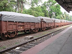
[[File:Iron Ore Train Goa 2.jpg|thumb|right|250px|Train carrying Iron Ore to Marmagao Port]] | [[File:Iron Ore Train Goa 2.jpg|thumb|right|250px|Train carrying Iron Ore to Marmagao Port]] | ||
Epidemics devastated Mormugao during the eighteenth century, but after that its fortunes turned. As the importance of one of India's best natural harbours grew more apparent, Mormugao, which the British called Marmagoa, became a key trading point. It was chosen for the terminus of the new [[metre gauge]]<ref>https://www.webcitation.org/ | Epidemics devastated Mormugao during the eighteenth century, but after that its fortunes turned. As the importance of one of India's best natural harbours grew more apparent, Mormugao, which the British called Marmagoa, became a key trading point. It was chosen for the terminus of the new [[metre gauge]]<ref>{{Cite web | title=This page was produced after reading my friend Apurva Bahadur's account of his 2001 holiday in Goa which brought back happy memories of my two brief visits there ( see Links page for details). | url=https://www.webcitation.org/5knvX7wWH?url=http://www.geocities.com/wp7713/vasco_vindaloo.htm | access-date=2025-10-05 | website=www.webcitation.org}}</ref> railway linking the Portuguese colony to British India. For a fabulous price, the [[Western India Portuguese Guaranteed Railways Company]], a British enterprise, modernised the port and built the railway. Both were opened to the public in July 1886.<ref>{{Cite web|url=http://theneutralview.com/reclaiming-vasco-da-gama-the-port-town/|title=RECLAIMING VASCO-DA-GAMA, THE PORT TOWN|date=2018-01-30|website=The Neutral View|language=en-US|access-date=2018-12-12}}</ref> | ||
Mormugao's city of [[Vasco da Gama, Goa|Vasco da Gama]] was planned and built in the early years of the twentieth century. A colourful city of officials, traders and migrant labourers, it had its Portuguese academies and British club life for several decades. Now rather scarred, Mormugão district continues to be unique in Goa. | Mormugao's city of [[Vasco da Gama, Goa|Vasco da Gama]] was planned and built in the early years of the twentieth century. A colourful city of officials, traders and migrant labourers, it had its Portuguese academies and British club life for several decades. Now rather scarred, Mormugão district continues to be unique in Goa. | ||
| Line 104: | Line 105: | ||
==Politics== | ==Politics== | ||
The area is part of the [[South Goa (Lok Sabha constituency)]] (also known as [[Mormugao (Goa Assembly constituency)|Mormugão (Lok Sabha constituency)]] ). In the 2019 Lok sabha elections, the [[South Goa (Lok Sabha constituency)|South Goa Lok Sabha constituency]] was again won by [[Francisco Sardinha]] of [[Indian National Congress]] defeating [[Narendra Keshav Sawaikar]] of [[Bharatiya Janata Party]], though [[Narendra Keshav Sawaikar|Sawaikar]] had managed to gain lead in all 4 lok sabha constituencies of Mormugao. | |||
Mormugao taluka also elects 4 MLAs to the [[Goa Legislative Assembly|Goa State Assembly]]. The current MLAs are [[Alina Saldanha]] from [[Cortalim (Goa Assembly constituency)]], [[Carlos Almeida (politician)|Carlos Almeida]] from [[Vasco Da Gama (Vidhan Sabha constituency)]], [[Milind Naik (politician)|Milind Naik]] from [[Mormugao (Goa Assembly constituency)]] and [[Mauvin Godinho]] from [[Dabolim (Goa Assembly constituency)]] all from the [[Bharatiya Janata Party]]. | |||
==Climate== | ==Climate== | ||
{{Weather box | {{Weather box | ||
| location = Mormugao ( | | location = Mormugao (1991–2020, extremes 1953–2020) | ||
| metric first = Y | | metric first = Y | ||
| single line = Y | | single line = Y | ||
| Jan record high C = 36. | | Jan record high C = 36.7 | ||
| Feb record high C = 37.8 | | Feb record high C = 37.8 | ||
| Mar record high C = 37.7 | | Mar record high C = 37.7 | ||
| Apr record high C = | | Apr record high C = 37.8 | ||
| May record high C = 38.4 | | May record high C = 38.4 | ||
| Jun record high C = 35. | | Jun record high C = 35.6 | ||
| Jul record high C = 32.7 | | Jul record high C = 32.7 | ||
| Aug record high C = 32.5 | | Aug record high C = 32.5 | ||
| Line 132: | Line 128: | ||
| year record high C = 38.4 | | year record high C = 38.4 | ||
| Jan high C = 31.8 | | Jan high C = 31.8 | ||
| Feb high C = 31. | | Feb high C = 31.6 | ||
| Mar high C = | | Mar high C = 32.1 | ||
| Apr high C = | | Apr high C = 33.1 | ||
| May high C = 33. | | May high C = 33.4 | ||
| Jun high C = 30. | | Jun high C = 30.9 | ||
| Jul high C = 29. | | Jul high C = 29.3 | ||
| Aug high C = | | Aug high C = 29.2 | ||
| Sep high C = | | Sep high C = 30.0 | ||
| Oct high C = 31.6 | | Oct high C = 31.6 | ||
| Nov high C = 33. | | Nov high C = 33.3 | ||
| Dec high C = 32. | | Dec high C = 32.8 | ||
| year high C = 31. | | year high C = 31.6 | ||
| Jan low C = 21. | | Jan low C = 21.7 | ||
| Feb low C = 22. | | Feb low C = 22.2 | ||
| Mar low C = 24.2 | | Mar low C = 24.2 | ||
| Apr low C = 26. | | Apr low C = 26.3 | ||
| May low C = 27. | | May low C = 27.0 | ||
| Jun low C = 25.2 | | Jun low C = 25.2 | ||
| Jul low C = 24. | | Jul low C = 24.4 | ||
| Aug low C = 24.2 | | Aug low C = 24.2 | ||
| Sep low C = 24. | | Sep low C = 24.2 | ||
| Oct low C = 24. | | Oct low C = 24.5 | ||
| Nov low C = 23. | | Nov low C = 23.9 | ||
| Dec low C = 22. | | Dec low C = 22.2 | ||
| year low C = 24.2 | | year low C = 24.2 | ||
| Jan record low C = 16.7 | | Jan record low C = 16.7 | ||
| Line 173: | Line 169: | ||
| Jan rain mm = 0.4 | | Jan rain mm = 0.4 | ||
| Feb rain mm = 0.0 | | Feb rain mm = 0.0 | ||
| Mar rain mm = 0. | | Mar rain mm = 0.5 | ||
| Apr rain mm = | | Apr rain mm = 5.6 | ||
| May rain mm = | | May rain mm = 79.4 | ||
| Jun rain mm = | | Jun rain mm = 840.0 | ||
| Jul rain mm = | | Jul rain mm = 885.2 | ||
| Aug rain mm = | | Aug rain mm = 518.2 | ||
| Sep rain mm = | | Sep rain mm = 288.5 | ||
| Oct rain mm = | | Oct rain mm = 156.2 | ||
| Nov rain mm = | | Nov rain mm = 22.4 | ||
| Dec rain mm = | | Dec rain mm = 3.2 | ||
| year rain mm = | | year rain mm = 2799.5 | ||
| Jan rain days = 0.2 | | Jan rain days = 0.2 | ||
| Feb rain days = 0.0 | | Feb rain days = 0.0 | ||
| Mar rain days = 0.1 | | Mar rain days = 0.1 | ||
| Apr rain days = 0. | | Apr rain days = 0.3 | ||
| May rain days = 3. | | May rain days = 3.4 | ||
| Jun rain days = 20. | | Jun rain days = 20.7 | ||
| Jul rain days = | | Jul rain days = 25.8 | ||
| Aug rain days = | | Aug rain days = 22.6 | ||
| Sep rain days = | | Sep rain days = 14.2 | ||
| Oct rain days = 6. | | Oct rain days = 6.7 | ||
| Nov rain days = 1. | | Nov rain days = 1.3 | ||
| Dec rain days = 0.4 | | Dec rain days = 0.4 | ||
| year rain days = | | year rain days = 95.7 | ||
|time day = 17:30 [[Indian Standard Time|IST]] | |time day = 17:30 [[Indian Standard Time|IST]] | ||
| Jan humidity = | | Jan humidity = 62 | ||
| Feb humidity = | | Feb humidity = 65 | ||
| Mar humidity = | | Mar humidity = 69 | ||
| Apr humidity = | | Apr humidity = 70 | ||
| May humidity = | | May humidity = 71 | ||
| Jun humidity = | | Jun humidity = 83 | ||
| Jul humidity = 86 | | Jul humidity = 86 | ||
| Aug humidity = | | Aug humidity = 86 | ||
| Sep humidity = 83 | | Sep humidity = 83 | ||
| Oct humidity = 78 | | Oct humidity = 78 | ||
| Nov humidity = 67 | | Nov humidity = 67 | ||
| Dec humidity = | | Dec humidity = 61 | ||
|year humidity = 74 | |year humidity = 74 | ||
|source 1 = [[India Meteorological Department]]<ref name=IMDnormals> | |source 1 = [[India Meteorological Department]]<ref>{{cite web | ||
| url = https://imdpune.gov.in/library/public/Climatological%20Tables%201991-2020.pdf | |||
| title = Climatological Tables of Observatories in India 1991-2020 | |||
| publisher = [[India Meteorological Department]] | |||
| access-date = April 8, 2024 | |||
}}</ref><ref name=IMDnormals> | |||
{{cite web | {{cite web | ||
| archive-url = https://web.archive.org/web/20200205040301/http://imdpune.gov.in/library/public/1981-2010%20CLIM%20NORMALS%20%28STATWISE%29.pdf | | archive-url = https://web.archive.org/web/20200205040301/http://imdpune.gov.in/library/public/1981-2010%20CLIM%20NORMALS%20%28STATWISE%29.pdf | ||
| Line 234: | Line 235: | ||
==Education== | ==Education== | ||
Murgaon Education Society was established in 1971 with the goal of providing educational facilities at Vasco-da-Gama and in other parts of Murgaon Taluka. Mormugao Educational Society's College of Arts and Commerce locally known as [[MES College]] is a famous institution situated in Zuarinagar, which provides higher education in Arts and Commerce along with [[Birla Institute of Technology and Science, Pilani – Goa Campus|Birla Institute of Science and Technology (BITS)]] that caters to university level of education in the fields of engineering and medicine. | |||
==See also== | ==See also== | ||
{{portal|Islands}} | |||
* [[Ports in India]] | * [[Ports in India]] | ||
* [[Mormugao Port Trust]] | * [[Mormugao Port Trust]] | ||
| Line 247: | Line 249: | ||
[[Category:Mormugao| ]] | [[Category:Mormugao| ]] | ||
[[Category:Cities and towns in South Goa district]] | [[Category:Cities and towns in South Goa district]] | ||
[[Category:Port cities in India]] | [[Category:Port cities and towns in India]] | ||
[[Category:Islands of India]] | |||
[[Category:Populated places in India]] | |||
Latest revision as of 03:42, 4 March 2026
 | This article needs more citations. (April 2015) |
Mormugao | |
|---|---|
City | |
 Aerial view of Mormugao Harbour | |
| Coordinates: 15°24′N 73°48′E / 15.40°N 73.80°E | |
| Country |  India India |
| State | Template:Seal |
| District | South Goa |
| Taluka | Mormugao taluka |
| Government | |
| • Type | Municipality |
| • Body | Mormugao Municipal Council |
| • chairperson | Girish Borkar |
| Area | |
| • Total | 65.62 km2 (25.34 sq mi) |
| Demonym | Mormuganvcar |
| Languages | |
| • Official | Konkani |
| Time zone | UTC+5:30 (IST) |
| PIN | 403601 |
| Vehicle registration | GA-06 |
| Website | www |
Mormugao is a coastal town situated in the eponymous subdistrict of Southern Goa state, India. It has a deep natural harbour and remains Goa's chief port.
Towards the end of the Indo-Portuguese era in 1917, thirty-one settlements were carved out of the Salcette territory, to form Mormugao with Mormugao seaport as its headquarters. The remaining thirty-five settlements were retained in Salcette which encompass the present-day Salcete taluka with Margao as its headquarters.[1]
Geography[edit | edit source]
Mormugao is located at 15°15′N 73°59′E / 15.25°N 73.98°E.[2] It has an average elevation of 2 metres (7 feet).
Demographics and Healthcare[edit | edit source]
As of 2001[update] India census,[3] Mormugao had a population of 97,085. Males constitute 53% of the population and females 47%. Mormugao has an average literacy rate of 75%, higher than the national average of 59.5%: male literacy is 80%, and female literacy is 70%. In Mormugão, 11% of the population is under 6 years of age. Konkani being the state language, Marathi, Kannada, Hindi and English are also spoken.
The Directorate of health services Goa (DHS) provides secondary level of healthcare to the people of mormugao and nearby places through the erstwhile Chicalim Cottage Hospital at Alto Chicalim now upgraded to the level of Sub District Hospital with 120 beds. The DHS also provides Primary Health Care to the taluka through PHC Casaulim, PHC Cortalim and UHC Vasco. A number of private nursing homes, clinics, panchkarma centres, gyms and physiotherapy centres can also be found in the subdistrict.
History[edit | edit source]


When the Portuguese colonised parts of Goa in the sixteenth century, they based their operations in the central district of Tiswadi, notably in the international emporium 'City of Goa', now Old Goa. As threats to their maritime supremacy increased, they built forts on various hillocks, especially along the coast. In 1624, they began to build their fortified town on the headland overlooking Mormugao harbour.
The sultans of Bijapur, who had ruled Goa before the Portuguese, did not give up easily. There were several invasions. From the sea came the Dutch, who eventually took over from the Portuguese most of the coastal settlements: the Moluccas, Batticaloa, Trincomali, Galle, Malacca, Manar, Jaffna, Quilon, Cochin and Cannanore. From 1640 to 1643, the Dutch tried their best to capture Mormugão but were finally driven away.
In 1683, the Portuguese in Goa were in grave danger from the Marathas. Almost certain defeat was averted when Sambhaji suddenly lifted the siege and rushed to defend his own kingdom from the Mughal Emperor Aurangzeb. The narrow escape, no less than the decline of the City of Goa, convinced the Portuguese viceroy, Dom Francisco de Távora, that he should shift the capital of the Portuguese holdings in India to Mormugao's formidable fortress.
In 1685, the new city's principal edifices were under construction, with the Jesuit priest Father Teotónio Rebelo in charge. The Jesuit architects made a consistent effort to avoid the ornate style of the time. The austere viceregal palace still stands, having been used, after its short stint as a palace, in various capacities, including as a hotel which housed the British agents who in 1943 destroyed German ships anchored in Mormugao's neutral waters. Viceroys after Távora found Mormugao too secluded for their liking. The administrative headquarters were moved to the new city of Panjim, which is still Goa's chief city.
During World War II, the harbour of Mormugao was the site of Operation Creek, which resulted in the bombing of a German merchant ship, Ehrenfels, which had secretly been transmitting information to U-boats.[4]
Mormugao Port[edit | edit source]
Ever since it was accorded the status of a Major Port in 1963, the Mormugao port has contributed immensely to growth of maritime trade in India. It is the leading iron ore exporting port of India with an annual throughput of around 27.33 million tonnes of iron ore traffic.[5]
The INS Mormugao has been named after the port.[6]
Transport links[edit | edit source]

Epidemics devastated Mormugao during the eighteenth century, but after that its fortunes turned. As the importance of one of India's best natural harbours grew more apparent, Mormugao, which the British called Marmagoa, became a key trading point. It was chosen for the terminus of the new metre gauge[7] railway linking the Portuguese colony to British India. For a fabulous price, the Western India Portuguese Guaranteed Railways Company, a British enterprise, modernised the port and built the railway. Both were opened to the public in July 1886.[8]
Mormugao's city of Vasco da Gama was planned and built in the early years of the twentieth century. A colourful city of officials, traders and migrant labourers, it had its Portuguese academies and British club life for several decades. Now rather scarred, Mormugão district continues to be unique in Goa.
With Goa's airport at Dabolim, the railway terminus at Vasco da Gama, and the busy port, Mormugao is many visitors’ first experience of Goa.
Politics[edit | edit source]
The area is part of the South Goa (Lok Sabha constituency) (also known as Mormugão (Lok Sabha constituency) ). In the 2019 Lok sabha elections, the South Goa Lok Sabha constituency was again won by Francisco Sardinha of Indian National Congress defeating Narendra Keshav Sawaikar of Bharatiya Janata Party, though Sawaikar had managed to gain lead in all 4 lok sabha constituencies of Mormugao.
Mormugao taluka also elects 4 MLAs to the Goa State Assembly. The current MLAs are Alina Saldanha from Cortalim (Goa Assembly constituency), Carlos Almeida from Vasco Da Gama (Vidhan Sabha constituency), Milind Naik from Mormugao (Goa Assembly constituency) and Mauvin Godinho from Dabolim (Goa Assembly constituency) all from the Bharatiya Janata Party.
Climate[edit | edit source]
| Climate data for Mormugao (1991–2020, extremes 1953–2020) | |||||||||||||
|---|---|---|---|---|---|---|---|---|---|---|---|---|---|
| Month | Jan | Feb | Mar | Apr | May | Jun | Jul | Aug | Sep | Oct | Nov | Dec | Year |
| Record high °C (°F) | 36.7 (98.1) |
37.8 (100.0) |
37.7 (99.9) |
37.8 (100.0) |
38.4 (101.1) |
35.6 (96.1) |
32.7 (90.9) |
32.5 (90.5) |
33.2 (91.8) |
36.8 (98.2) |
36.7 (98.1) |
36.6 (97.9) |
38.4 (101.1) |
| Average high °C (°F) | 31.8 (89.2) |
31.6 (88.9) |
32.1 (89.8) |
33.1 (91.6) |
33.4 (92.1) |
30.9 (87.6) |
29.3 (84.7) |
29.2 (84.6) |
30.0 (86.0) |
31.6 (88.9) |
33.3 (91.9) |
32.8 (91.0) |
31.6 (88.9) |
| Average low °C (°F) | 21.7 (71.1) |
22.2 (72.0) |
24.2 (75.6) |
26.3 (79.3) |
27.0 (80.6) |
25.2 (77.4) |
24.4 (75.9) |
24.2 (75.6) |
24.2 (75.6) |
24.5 (76.1) |
23.9 (75.0) |
22.2 (72.0) |
24.2 (75.6) |
| Record low °C (°F) | 16.7 (62.1) |
17.2 (63.0) |
17.3 (63.1) |
20.6 (69.1) |
20.7 (69.3) |
17.0 (62.6) |
20.2 (68.4) |
19.3 (66.7) |
21.1 (70.0) |
18.3 (64.9) |
12.2 (54.0) |
17.2 (63.0) |
12.2 (54.0) |
| Average rainfall mm (inches) | 0.4 (0.02) |
0.0 (0.0) |
0.5 (0.02) |
5.6 (0.22) |
79.4 (3.13) |
840.0 (33.07) |
885.2 (34.85) |
518.2 (20.40) |
288.5 (11.36) |
156.2 (6.15) |
22.4 (0.88) |
3.2 (0.13) |
2,799.5 (110.22) |
| Average rainy days | 0.2 | 0.0 | 0.1 | 0.3 | 3.4 | 20.7 | 25.8 | 22.6 | 14.2 | 6.7 | 1.3 | 0.4 | 95.7 |
| Average relative humidity (%) (at 17:30 IST) | 62 | 65 | 69 | 70 | 71 | 83 | 86 | 86 | 83 | 78 | 67 | 61 | 74 |
| Source: India Meteorological Department[9][10][11] | |||||||||||||
Education[edit | edit source]
Murgaon Education Society was established in 1971 with the goal of providing educational facilities at Vasco-da-Gama and in other parts of Murgaon Taluka. Mormugao Educational Society's College of Arts and Commerce locally known as MES College is a famous institution situated in Zuarinagar, which provides higher education in Arts and Commerce along with Birla Institute of Science and Technology (BITS) that caters to university level of education in the fields of engineering and medicine.
See also[edit | edit source]
References[edit | edit source]
- ↑ Pinho, Vasco (2007). "Snapshots" of Indo-Portuguese history, Volume 1. p. 122.
- ↑ Falling Rain Genomics, Inc - Mormugao[permanent dead link]
- ↑ "Census of India 2001: Data from the 2001 Census, including cities, villages and towns (Provisional)". Census Commission of India. Archived from the original on 16 June 2004. Retrieved 1 November 2008.
- ↑ "MPT to salvage remnants of German ships wrecked in World War II". The Indian Express. 12 October 2017. Retrieved 16 April 2020.
- ↑ "Mormugao, Mormugao Port Trust Goa, Goa, Official Website of Mormugao Port Trust". Archived from the original on 21 February 2009. Retrieved 8 April 2009.
- ↑ "New Navy destroyer to be named after Goa port". Archived from the original on 2 May 2021.
- ↑ "This page was produced after reading my friend Apurva Bahadur's account of his 2001 holiday in Goa which brought back happy memories of my two brief visits there ( see Links page for details)". www.webcitation.org. Retrieved 5 October 2025.
- ↑ "RECLAIMING VASCO-DA-GAMA, THE PORT TOWN". The Neutral View. 30 January 2018. Retrieved 12 December 2018.
- ↑ "Climatological Tables of Observatories in India 1991-2020" (PDF). India Meteorological Department. Retrieved 8 April 2024.
- ↑ "Station: Marmugao (Mormugao) Climatological Table 1981–2010" (PDF). Climatological Normals 1981–2010. India Meteorological Department. January 2015. pp. 501–502. Archived from the original (PDF) on 5 February 2020. Retrieved 19 February 2020.
- ↑ "Extremes of Temperature & Rainfall for Indian Stations (Up to 2012)" (PDF). India Meteorological Department. December 2016. p. M47. Archived from the original (PDF) on 5 February 2020. Retrieved 19 February 2020.