




Actually damodar river originates from Latehar district but not from Lohardaga district |
m General improvements to article content |
||
| Line 1: | Line 1: | ||
{{Short description|River in Jharkhand and West Bengal, | {{Short description|River in Jharkhand and West Bengal, India}} | ||
{{Infobox river | {{Infobox river | ||
| image = Damodar River 1.jpg | | image = Damodar River 1.jpg | ||
| Line 11: | Line 11: | ||
| mouth_location = [[Hooghly River]], [[Howrah district]], [[West Bengal]] | | mouth_location = [[Hooghly River]], [[Howrah district]], [[West Bengal]] | ||
| discharge1_avg = {{convert|296|m3/s|abbr=on}}<ref>{{citation| title = Damodar Basin Station: Rhondia| publisher = UNH/GRDC| url = http://www.compositerunoff.sr.unh.edu/html/Polygons/P2854050.html}}</ref> | | discharge1_avg = {{convert|296|m3/s|abbr=on}}<ref>{{citation| title = Damodar Basin Station: Rhondia| publisher = UNH/GRDC| url = http://www.compositerunoff.sr.unh.edu/html/Polygons/P2854050.html}}</ref> | ||
| source1_location = [[ | | source1_location = [[Chulhapani]], [[Latehar district]], [[Chota Nagpur Plateau]], [[Jharkhand]] | ||
| tributaries_left = [[Barakar River|Barakar]], [[Konar River|Konar]], [[Jamunia River|Jamunia]], [[Nunia River|Nunia]] | | tributaries_left = [[Barakar River|Barakar]], [[Konar River|Konar]], [[Jamunia River|Jamunia]], [[Nunia River|Nunia]] | ||
| tributaries_right= [[Sali River | | tributaries_right= [[Sali River (West Bengal)]] | ||
| map = Damodar Map.jpg | | map = Damodar Map.jpg | ||
| map_alt = Damodar Map | | map_alt = Damodar Map | ||
| map_caption = Damodar Map | | map_caption = Damodar Map | ||
}} | }} | ||
'''Damodar River''' (Pron: /ˈdʌmoˌdaː/) is a river flowing across the [[India]]n [[States and territories of India|states]] of [[Jharkhand]] and [[West Bengal]]. | '''Damodar River''' (Pron: /ˈdʌmoˌdaː/) is a river flowing across the [[India]]n [[States and territories of India|states]] of [[Jharkhand]] and [[West Bengal]]. The valley is rich in [[Natural resources of India|mineral resources]] and is known for large-scale [[Mining in India|mining]] and [[Economy of India|industrial]] activity. It was also known as the '''Sorrow of Bengal'''<ref>{{cite web |url=http://qna.rediff.com/questions-and-answers/river-damodar-is-called-sorrow-of-bengal-because-i/22849400/answers/22849402 |title=River Damodar is called Sorrow of Bengal because it (A) Causes maximum soil erosion (B) Gets flooded often causing havoc (C) Forms number of dangerous waterfalls (D) is not a perennial river - Rediff Questions & Answers |access-date=2013-10-22 |url-status=dead |archive-url=https://archive.today/20131022133126/http://qna.rediff.com/questions-and-answers/river-damodar-is-called-sorrow-of-bengal-because-i/22849400/answers/22849402 |archive-date=2013-10-22 }}</ref> because of the [[Floods in India|ravaging floods]] it caused in the plains of West Bengal. The construction of several [[List of dams and reservoirs in India|dams]] on the Damodar and its [[Tributary|tributaries]] has helped control some of the flooding. | ||
==Etymology== | ==Etymology== | ||
Damodar means "rope around the belly", derived from [[Sanskrit]] दाम (dama) "rope" and उदर (udara) "belly". Damodar is also another name given to the [[Hindu deities|Hindu god]] [[Krishna]]<ref>{{cite journal |last1=Ghosh |first1=Pika |title=Tales, Tanks, and Temples: The Creation of a Sacred Center in Seventeenth-Century Bengal |journal=Asian Folklore Studies |date=2002 |volume=61 |issue=2 |pages=193–222 |doi=10.2307/1178971 |url=https://www.jstor.org/stable/1178971 |issn=0385-2342|url-access=subscription }}</ref> because his foster-mother, [[Yashoda]], had tied him to a large urn.<ref name = "chattopadhyay">Chattopadhyay, Akkori, ''Bardhaman Jelar Itihas O Lok Sanskriti'' (History and Folk lore of Bardhaman District.), {{in lang|bn}}, Vol I, pp. 21- 26, Radical Impression. {{ISBN|81-85459-36-3}}</ref> | |||
== Course == | |||
The Damodar is a rain-fed river. It originates in Khamarpat Hill on Chotanagpur Plateau in Jharkhand.<ref>{{Cite book |last=Sen Singh |first=Dhruv |title=The Indian rivers : scientific and socio-economic aspects |date= |publisher=Springer Hydrogeology |others= |year=2018 |location=Singapore |pages=259}}</ref> It travels {{Convert|368|miles|km|abbr=on}} before joining the [[Hooghly River]] in [[Howrah district|Howrah]], in [[West Bengal]].<ref>{{Cite web |title=Damodar River {{!}} river, India {{!}} Britannica |url=https://www.britannica.com/place/Damodar-River |access-date=2023-03-03 |website=www.britannica.com |language=en}}</ref> | |||
==Tributaries== | ==Tributaries== | ||
Damodar River has a number of tributaries and subtributaries, such as [[Barakar River|Barakar]], [[Konar River|Konar]], [[Bokaro River|Bokaro]], Haharo, [[Jamunia River|Jamunia]], Ghari, Guaia, Khadia and Bhera.<ref name = "chattopadhyay"/><ref name = sabharwal>Sabharwal, L.R., I.F.S., Conservator of Forests, Bihar, Notes as part of Appendix IV to ''Report of the Damodar Flood Enquiry Committee'', 1943, republished in ''Rivers of Bengal'', a compilation, Vol III, 2002, p. 236, West Bengal District Gazetteers, Government of West Bengal</ref> The Damodar and the Barakar trifurcate the Chota Nagpur plateau. The rivers pass through hilly areas with great force, sweeping away whatever lies in their path. Two bridges on the [[Grand Trunk Road]] near Barhi in Hazaribagh district were torn down by the Barakar: the great stone bridge in 1913 and the subsequent iron bridge in 1946.<ref>[[John Wardle Houlton|Sir John Houlton]], ''Bihar the Heart of India'', 1949, p. 117, Orient Longmans Ltd.</ref> | |||
==River of Sorrows== | ==River of Sorrows== | ||
The Chota Nagpur Plateau receives an average annual rainfall of around {{convert|1400|mm|in|abbr=on}}, almost all of it in the monsoon months between June and August.<ref>{{cite web|url=http://envfor.nic.in/divisions/cltech/Damodar/1.1.htm |title=Damodar Valley |access-date=2008-05-25 |work=About the Region – Damodar Basin |publisher=Ministry of Environments and Forests |url-status=dead |archive-url=https://web.archive.org/web/20070927182506/http://envfor.nic.in/divisions/cltech/Damodar/1.1.htm |archive-date=2007-09-27 }}</ref> The huge volume of water that flows down the Damodar and its tributaries during the monsoons used to be a fury in the upper reaches of the valley. In the lower valley it used to overflow its banks and flood large areas. | The Chota Nagpur Plateau receives an average annual rainfall of around {{convert|1400|mm|in|abbr=on}}, almost all of it in the monsoon months between June and August.<ref>{{cite web|url=http://envfor.nic.in/divisions/cltech/Damodar/1.1.htm |title=Damodar Valley |access-date=2008-05-25 |work=About the Region – Damodar Basin |publisher=Ministry of Environments and Forests |url-status=dead |archive-url=https://web.archive.org/web/20070927182506/http://envfor.nic.in/divisions/cltech/Damodar/1.1.htm |archive-date=2007-09-27 }}</ref> The huge volume of water that flows down the Damodar and its tributaries during the monsoons used to be a fury in the upper reaches of the valley. In the lower valley it used to overflow its banks and flood large areas. | ||
Damodar River was earlier known as the "River of Sorrows"<ref>Bose, Dr. N.K., ''The Problems of Damodar'', Appendix IV to ''Report of the Damodar Flood Enquiry Committee'', 1943, republished in ''Rivers of Bengal'', a compilation, Vol III, 2002, p. 204</ref> as it used to flood many areas of [[Bardhaman]], [[Hooghly District|Hooghly]], [[Howrah]] and [[Medinipur district|Medinipur]] districts | Damodar River was earlier known as the "River of Sorrows"<ref>Bose, Dr. N.K., ''The Problems of Damodar'', Appendix IV to ''Report of the Damodar Flood Enquiry Committee'', 1943, republished in ''Rivers of Bengal'', a compilation, Vol III, 2002, p. 204</ref> as it used to flood many areas of [[Bardhaman]], [[Hooghly District|Hooghly]], [[Howrah]] and [[Medinipur district|Medinipur]] districts. | ||
The floods were virtually an annual ritual. In some years the damage was probably more. Many of the great floods of the Damodar are recorded in history — 1770, 1855, 1866, 1873–74, 1875–76, 1884–85, 1891–92, 1897, 1900, 1907, 1913, 1927, 1930, 1935 and 1943. In four of these floods (1770, 1855, 1913 and 1943) most of Bardhaman town was flooded. | The floods were virtually an annual ritual. In some years the damage was probably more. Many of the great floods of the Damodar are recorded in history — 1770, 1855, 1866, 1873–74, 1875–76, 1884–85, 1891–92, 1897, 1900, 1907, 1913, 1927, 1930, 1935 and 1943. In four of these floods (1770, 1855, 1913 and 1943) most of Bardhaman town was flooded. | ||
| Line 35: | Line 38: | ||
In 1789 an agreement was signed between [[Bardhaman Raj#Kirtichand Rai|Maharaja Kirti Chand]] of [[Bardhaman Raj|Burdwan]] and the [[East India Company]] wherein the Maharaja was asked to pay an additional amount of {{INRconvert|193.721|k|to=USD GBP|year=1789}} for the construction and maintenance of embankment to prevent floods. However, these ran into dispute and in 1866 and 1873, ''The Bengal Embankment Act'' was passed, transferring the powers to build and maintain embankment to the government. | In 1789 an agreement was signed between [[Bardhaman Raj#Kirtichand Rai|Maharaja Kirti Chand]] of [[Bardhaman Raj|Burdwan]] and the [[East India Company]] wherein the Maharaja was asked to pay an additional amount of {{INRconvert|193.721|k|to=USD GBP|year=1789}} for the construction and maintenance of embankment to prevent floods. However, these ran into dispute and in 1866 and 1873, ''The Bengal Embankment Act'' was passed, transferring the powers to build and maintain embankment to the government. | ||
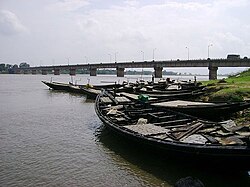
[[File:Damodar River.jpg|thumb|260px|right|Krishak Setu over the Damodar River, near | [[File:Damodar River.jpg|thumb|260px|right|Krishak Setu over the Damodar River, near Bardhaman]] | ||
[[File:Damodar dhanbad-bokaro.jpg|thumb|260px|right|Damodar River between Dhanbad and Bokaro]] | |||
So great was the devastation every year that the floods passed into folklore, as the following [[Bhadu (festival)|Bhadu]] song testifies: | So great was the devastation every year that the floods passed into folklore, as the following [[Bhadu (festival)|Bhadu]] song testifies: | ||
| Line 49: | Line 54: | ||
==Damodar Valley==<!-- This section is linked from [[Jharkhand]] --> | ==Damodar Valley==<!-- This section is linked from [[Jharkhand]] --> | ||
The Damodar Valley is spread across [[Hazaribagh District|Hazaribagh]], [[Ramgarh District|Ramgarh]], [[ | The Damodar Valley is spread across [[Hazaribagh District|Hazaribagh]], [[Ramgarh District|Ramgarh]], [[Latehar District|latehar]], [[Dhanbad District|Dhanbad]], [[Bokaro District|Bokaro]] and [[Chatra District|Chatra]], Ranchi districts in [[Jharkhand]] and [[Bardhaman District|Bardhaman]] and [[Hooghly District|Hooghly]] districts in [[West Bengal]] and partially covers [[Palamu District|Palamu]], [[Ranchi District|Ranchi]], [[Lohardaga District|Lohardaga]] and [[Dumka District|Dumka]] districts in Jharkhand and [[Howrah District|Howrah]], [[Bankura District|Bankura]] and [[Purulia District|Purulia]] districts in West Bengal with a command area of {{convert|24235|km2|mi2}}. | ||
The Damodar valley is rich in coal. It is considered as the prime centre of coking coal in the country. Massive deposits are found in the central basin spreading over {{convert|2883|km2|mi2}}. The important coalfields in the basin are [[Jharia]], [[Raniganj Coalfield|Raniganj]], [[West Bokaro Coalfield|West Bokaro]], [[East Bokaro Coalfield|East Bokaro]], [[Ramgarh Coalfield|Ramgarh]], [[South Karanpura Coalfield|South Karanpura]] and [[North Karanpura Coalfield|North Karanpura]].<ref>{{cite web|url=http://envfor.nic.in/divisions/cltech/Damodar/2.4.htm |title=Mineral Resources and Coal Mining |access-date=2010-05-03 |url-status=dead |archive-url=https://web.archive.org/web/20110815182912/http://envfor.nic.in/divisions/cltech/Damodar/2.4.htm |archive-date=2011-08-15 }}</ref> | The Damodar valley is rich in coal. It is considered as the prime centre of coking coal in the country. Massive deposits are found in the central basin spreading over {{convert|2883|km2|mi2}}. The important coalfields in the basin are [[Jharia]], [[Raniganj Coalfield|Raniganj]], [[West Bokaro Coalfield|West Bokaro]], [[East Bokaro Coalfield|East Bokaro]], [[Ramgarh Coalfield|Ramgarh]], [[South Karanpura Coalfield|South Karanpura]] and [[North Karanpura Coalfield|North Karanpura]].<ref>{{cite web|url=http://envfor.nic.in/divisions/cltech/Damodar/2.4.htm |title=Mineral Resources and Coal Mining |access-date=2010-05-03 |url-status=dead |archive-url=https://web.archive.org/web/20110815182912/http://envfor.nic.in/divisions/cltech/Damodar/2.4.htm |archive-date=2011-08-15 }}</ref> | ||
| Line 61: | Line 66: | ||
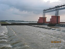
[[File:Rundiha weir.jpg|thumb|[[Randiha]][[weir]] on lower Damodar]] | [[File:Rundiha weir.jpg|thumb|[[Randiha]][[weir]] on lower Damodar]] | ||
The initial focus of the DVC were flood control, irrigation, generation, transmission and distribution of electricity, eco-conservation and afforestation, as well as job creation for the socio-economic well-being of the people residing in and around areas affected by DVC projects. However, over the past few decades, power generation has gained priority. Other objectives of the DVC remain part of its primary responsibility. The dams in the valley have a capacity to moderate peak floods of {{convert|250000|to|650000|ft3/s|m3/s|order=flip}}. DVC has created irrigation potential of {{convert|3640|km2|mi2}}. | The initial focus of the DVC were flood control, irrigation, generation, transmission and distribution of electricity, eco-conservation and afforestation, as well as job creation for the socio-economic well-being of the people residing in and around areas affected by DVC projects. However, over the past few decades, power generation has gained priority. Other objectives of the DVC remain part of its primary responsibility. The dams in the valley have a capacity to moderate peak floods of {{convert|250000|to|650000|ft3/s|m3/s|order=flip}}. DVC has created irrigation potential of {{convert|3640|km2|mi2}}. | ||
[[File: | [[File:Damodar River Beach Burdwan.jpg|alt=Damodar River Beach At Sadarghat Burdwan|thumb|300px|left|Damodar River Beach Burdwan]] | ||
The first dam was built across the [[Barakar River]], a tributary of the Damodar river at [[Tilaiya]] in 1953. The second one was built across the [[Konar River]], another tributary of the Damodar river at [[Konar Dam|Konar]] in 1955. Two dams across the rivers Barakar and Damodar were built at [[Maithon]] in 1957 and [[Panchet]] in 1958. Both the dams are some {{convert|8|km|mi|0}} upstream of the confluence point of the rivers. These four major dams are controlled by DVC. [[Durgapur Barrage]] was constructed downstream of the four dams in 1955, across the Damodar river at Durgapur, with head regulators for canals on either side for feeding an extensive system of canals and distributaries.<ref>{{cite web |url=http://www.dvcindia.org/activitiesgeneration.htm |title=Damodar Valley Corporation |access-date=2008-05-25 |work=Generation – Overview |publisher=Damodar Valley Corporation |url-status=dead |archive-url=https://web.archive.org/web/20080517111812/http://www.dvcindia.org/activitiesgeneration.htm |archive-date=2008-05-17 }}</ref><ref>{{cite web |url=http://www.dvcindia.org/activitiesdamsbarrages.htm |title=Damodar Valley Corporation |access-date=2008-05-25 |work=Generation – Overview – Dams and Barrages |publisher=Damodar Valley Corporation |url-status=dead |archive-url=https://web.archive.org/web/20080515015807/http://www.dvcindia.org/activitiesdamsbarrages.htm |archive-date=2008-05-15 }}</ref> In 1978, the government of Bihar (that was before the formation of the state of Jharkhand) constructed the [[Tenughat Dam]] across the Damodar river outside the control of DVC.<ref>{{cite web | url = http://www.apfm.info/pdf/case_studies/cs_india.pdf | The first dam was built across the [[Barakar River]], a tributary of the Damodar river at [[Tilaiya]] in 1953. The second one was built across the [[Konar River]], another tributary of the Damodar river at [[Konar Dam|Konar]] in 1955. Two dams across the rivers Barakar and Damodar were built at [[Maithon]] in 1957 and [[Panchet]] in 1958. Both the dams are some {{convert|8|km|mi|0}} upstream of the confluence point of the rivers. These four major dams are controlled by DVC. [[Durgapur Barrage]] was constructed downstream of the four dams in 1955, across the Damodar river at Durgapur, with head regulators for canals on either side for feeding an extensive system of canals and distributaries.<ref>{{cite web |url=http://www.dvcindia.org/activitiesgeneration.htm |title=Damodar Valley Corporation |access-date=2008-05-25 |work=Generation – Overview |publisher=Damodar Valley Corporation |url-status=dead |archive-url=https://web.archive.org/web/20080517111812/http://www.dvcindia.org/activitiesgeneration.htm |archive-date=2008-05-17 }}</ref><ref>{{cite web |url=http://www.dvcindia.org/activitiesdamsbarrages.htm |title=Damodar Valley Corporation |access-date=2008-05-25 |work=Generation – Overview – Dams and Barrages |publisher=Damodar Valley Corporation |url-status=dead |archive-url=https://web.archive.org/web/20080515015807/http://www.dvcindia.org/activitiesdamsbarrages.htm |archive-date=2008-05-15 }}</ref> In 1978, the government of Bihar (that was before the formation of the state of Jharkhand) constructed the [[Tenughat Dam]] across the Damodar river outside the control of DVC.<ref>{{cite web | url = http://www.apfm.info/pdf/case_studies/cs_india.pdf | title = The Associated Programme On Flood Management | access-date = 2008-05-25| work = Case Study -- India: Flood Management – Damodar River Basin | publisher = World Meteorological Organization}}</ref> It proposes constructing a dam across the Barakar river at Belpahari in Jharkhand state.<ref>{{cite web |url=http://www.hinduonnet.com/businessline/2001/03/10/stories/1410566k.htm |title=DVC plans to double capacity |access-date=2008-05-25 |last=Dutta |first=Indrani |publisher=The Hindu Business Line 10 March 2001 |url-status=usurped |archive-url=https://web.archive.org/web/20080323021013/http://www.hinduonnet.com/businessline/2001/03/10/stories/1410566k.htm |archive-date=2008-03-23 }}</ref> | ||
{{clear}} | {{clear}} | ||
==References== | ==References== | ||
{{Reflist|2}} | {{Reflist|2}} | ||
| Line 79: | Line 85: | ||
[[Category:Rivers of Jharkhand]] | [[Category:Rivers of Jharkhand]] | ||
[[Category:Rivers of West Bengal]] | [[Category:Rivers of West Bengal]] | ||
Latest revision as of 06:57, 31 January 2026
| Damodar River | |
|---|---|
 Damodar River in the lower reaches of the Chota Nagpur Plateau in dry season | |
 Damodar Map | |
| Location | |
| Country | India |
| Location | Jharkhand, West Bengal |
| Physical characteristics | |
| Source | |
| • location | Chulhapani, Latehar district, Chota Nagpur Plateau, Jharkhand |
| Mouth | |
• location | Hooghly River, Howrah district, West Bengal |
| Length | 592 km (368 mi) |
| Discharge | |
| • average | 296 m3/s (10,500 cu ft/s)[1] |
| Basin features | |
| Tributaries | |
| • left | Barakar, Konar, Jamunia, Nunia |
| • right | Sali River (West Bengal) |
Damodar River (Pron: /ˈdʌmoˌdaː/) is a river flowing across the Indian states of Jharkhand and West Bengal. The valley is rich in mineral resources and is known for large-scale mining and industrial activity. It was also known as the Sorrow of Bengal[2] because of the ravaging floods it caused in the plains of West Bengal. The construction of several dams on the Damodar and its tributaries has helped control some of the flooding.
Etymology[edit | edit source]
Damodar means "rope around the belly", derived from Sanskrit दाम (dama) "rope" and उदर (udara) "belly". Damodar is also another name given to the Hindu god Krishna[3] because his foster-mother, Yashoda, had tied him to a large urn.[4]
Course[edit | edit source]
The Damodar is a rain-fed river. It originates in Khamarpat Hill on Chotanagpur Plateau in Jharkhand.[5] It travels 368 mi (592 km) before joining the Hooghly River in Howrah, in West Bengal.[6]
Tributaries[edit | edit source]
Damodar River has a number of tributaries and subtributaries, such as Barakar, Konar, Bokaro, Haharo, Jamunia, Ghari, Guaia, Khadia and Bhera.[4][7] The Damodar and the Barakar trifurcate the Chota Nagpur plateau. The rivers pass through hilly areas with great force, sweeping away whatever lies in their path. Two bridges on the Grand Trunk Road near Barhi in Hazaribagh district were torn down by the Barakar: the great stone bridge in 1913 and the subsequent iron bridge in 1946.[8]
River of Sorrows[edit | edit source]
The Chota Nagpur Plateau receives an average annual rainfall of around 1,400 mm (55 in), almost all of it in the monsoon months between June and August.[9] The huge volume of water that flows down the Damodar and its tributaries during the monsoons used to be a fury in the upper reaches of the valley. In the lower valley it used to overflow its banks and flood large areas.
Damodar River was earlier known as the "River of Sorrows"[10] as it used to flood many areas of Bardhaman, Hooghly, Howrah and Medinipur districts.
The floods were virtually an annual ritual. In some years the damage was probably more. Many of the great floods of the Damodar are recorded in history — 1770, 1855, 1866, 1873–74, 1875–76, 1884–85, 1891–92, 1897, 1900, 1907, 1913, 1927, 1930, 1935 and 1943. In four of these floods (1770, 1855, 1913 and 1943) most of Bardhaman town was flooded.
In 1789 an agreement was signed between Maharaja Kirti Chand of Burdwan and the East India Company wherein the Maharaja was asked to pay an additional amount of ₹193,721 (Template:INRConvert/USD GBP) for the construction and maintenance of embankment to prevent floods. However, these ran into dispute and in 1866 and 1873, The Bengal Embankment Act was passed, transferring the powers to build and maintain embankment to the government.


So great was the devastation every year that the floods passed into folklore, as the following Bhadu song testifies:
- We have sown the crops in Asar
- We will bring Bhadu in Bhadra.
- Floods have swollen the Damodar
- The sailing boats cannot sail.
- O Damodar! We fall at your feet
- Reduce the floods a little.
- Bhadu will come a year later
- Let the boats sail on your surface.

Damodar Valley[edit | edit source]
The Damodar Valley is spread across Hazaribagh, Ramgarh, latehar, Dhanbad, Bokaro and Chatra, Ranchi districts in Jharkhand and Bardhaman and Hooghly districts in West Bengal and partially covers Palamu, Ranchi, Lohardaga and Dumka districts in Jharkhand and Howrah, Bankura and Purulia districts in West Bengal with a command area of 24,235 square kilometres (9,357 sq mi).
The Damodar valley is rich in coal. It is considered as the prime centre of coking coal in the country. Massive deposits are found in the central basin spreading over 2,883 square kilometres (1,113 sq mi). The important coalfields in the basin are Jharia, Raniganj, West Bokaro, East Bokaro, Ramgarh, South Karanpura and North Karanpura.[11]
The Damodar Valley is one of the most industrialised parts of India. Three integrated steel plants (Bokaro, Burnpur and Durgapur) of Steel Authority of India Limited (SAIL) and other factories are in the valley.
Damodar Valley Corporation (D.V.C.)[edit | edit source]
Several dams have been constructed in the valley, for the generation of hydroelectric power. The valley is called “the Ruhr of India”. Damodar Valley Corporation, popularly known as DVC, came into being on July 7, 1948, by an Act of the Constituent Assembly of India (Act No. XIV of 1948) as the first multipurpose river valley project of independent India.[12] It is modeled on the Tennessee Valley Authority of the United States.[13]

The initial focus of the DVC were flood control, irrigation, generation, transmission and distribution of electricity, eco-conservation and afforestation, as well as job creation for the socio-economic well-being of the people residing in and around areas affected by DVC projects. However, over the past few decades, power generation has gained priority. Other objectives of the DVC remain part of its primary responsibility. The dams in the valley have a capacity to moderate peak floods of 7,100 to 18,400 cubic metres per second (250,000 to 650,000 cu ft/s). DVC has created irrigation potential of 3,640 square kilometres (1,410 sq mi).

The first dam was built across the Barakar River, a tributary of the Damodar river at Tilaiya in 1953. The second one was built across the Konar River, another tributary of the Damodar river at Konar in 1955. Two dams across the rivers Barakar and Damodar were built at Maithon in 1957 and Panchet in 1958. Both the dams are some 8 kilometres (5 mi) upstream of the confluence point of the rivers. These four major dams are controlled by DVC. Durgapur Barrage was constructed downstream of the four dams in 1955, across the Damodar river at Durgapur, with head regulators for canals on either side for feeding an extensive system of canals and distributaries.[14][15] In 1978, the government of Bihar (that was before the formation of the state of Jharkhand) constructed the Tenughat Dam across the Damodar river outside the control of DVC.[16] It proposes constructing a dam across the Barakar river at Belpahari in Jharkhand state.[17]
References[edit | edit source]
- ↑ Damodar Basin Station: Rhondia, UNH/GRDC
- ↑ "River Damodar is called Sorrow of Bengal because it (A) Causes maximum soil erosion (B) Gets flooded often causing havoc (C) Forms number of dangerous waterfalls (D) is not a perennial river - Rediff Questions & Answers". Retrieved 2013-10-22.
{{cite web}}: CS1 maint: deprecated archival service (link) - ↑ Ghosh, Pika (2002). "Tales, Tanks, and Temples: The Creation of a Sacred Center in Seventeenth-Century Bengal". Asian Folklore Studies. 61 (2): 193–222. doi:10.2307/1178971. ISSN 0385-2342.
- ↑ 4.0 4.1 Chattopadhyay, Akkori, Bardhaman Jelar Itihas O Lok Sanskriti (History and Folk lore of Bardhaman District.), (in Bengali), Vol I, pp. 21- 26, Radical Impression. ISBN 81-85459-36-3
- ↑ Sen Singh, Dhruv (2018). The Indian rivers : scientific and socio-economic aspects. Singapore: Springer Hydrogeology. p. 259.
- ↑ "Damodar River | river, India | Britannica". www.britannica.com. Retrieved 2023-03-03.
- ↑ Sabharwal, L.R., I.F.S., Conservator of Forests, Bihar, Notes as part of Appendix IV to Report of the Damodar Flood Enquiry Committee, 1943, republished in Rivers of Bengal, a compilation, Vol III, 2002, p. 236, West Bengal District Gazetteers, Government of West Bengal
- ↑ Sir John Houlton, Bihar the Heart of India, 1949, p. 117, Orient Longmans Ltd.
- ↑ "Damodar Valley". About the Region – Damodar Basin. Ministry of Environments and Forests. Archived from the original on 2007-09-27. Retrieved 2008-05-25.
- ↑ Bose, Dr. N.K., The Problems of Damodar, Appendix IV to Report of the Damodar Flood Enquiry Committee, 1943, republished in Rivers of Bengal, a compilation, Vol III, 2002, p. 204
- ↑ "Mineral Resources and Coal Mining". Archived from the original on 2011-08-15. Retrieved 2010-05-03.
- ↑ "Damodar Valley Corporation". Infrastructure – DVC Act. Damodar Valley Corporation. Archived from the original on 2008-05-26. Retrieved 2008-05-25.
- ↑ "Damodar Valley Corporation". Infrastructure – Formation. Damodar Valley Corporation. Archived from the original on 2008-05-26. Retrieved 2008-05-25.
- ↑ "Damodar Valley Corporation". Generation – Overview. Damodar Valley Corporation. Archived from the original on 2008-05-17. Retrieved 2008-05-25.
- ↑ "Damodar Valley Corporation". Generation – Overview – Dams and Barrages. Damodar Valley Corporation. Archived from the original on 2008-05-15. Retrieved 2008-05-25.
- ↑ "The Associated Programme On Flood Management" (PDF). Case Study -- India: Flood Management – Damodar River Basin. World Meteorological Organization. Retrieved 2008-05-25.
- ↑ Dutta, Indrani. "DVC plans to double capacity". The Hindu Business Line 10 March 2001. Archived from the original on 2008-03-23. Retrieved 2008-05-25.