





Dhaneesh Ram (talk | contribs) No edit summary Tags: Mobile edit Mobile web edit Advanced mobile edit |
Dhaneesh Ram (talk | contribs) No edit summary Tags: Mobile edit Mobile web edit Advanced mobile edit |
||
| Line 114: | Line 114: | ||
== Demographics == | == Demographics == | ||
{{historical populations|11=1901|12=697,894|13=1911|14=754,483|15=1921|16=787,002|17=1931|18=914,515|19=1941|20=1,050,676|21=1951|22=1,259,135|23=1961|24=1,501,084|25=1971|26=1,886,146|27=1981|28=2,216,562|29=1991|30=2,493,715|31=2001|32=2,916,620|33=2011|34=3,458,045|percentages=pagr|footnote=source:<ref>[http://www.censusindia.gov.in/2011census/PCA/A2_Data_Table.html Decadal Variation In Population Since 1901]</ref>|align=right}}According to [[2011 census of India|2011 census]], Coimbatore district had a population of 3,458,045 with a sex-ratio of 1,000 females for every 1,000 males, much above the national average of 929.<ref name="dashboard">{{cite web|title=Census Info 2011 Final population totals|url=http://www.censusindia.gov.in/2011census/censusinfodashboard/index.html|publisher=Office of The Registrar General and Census Commissioner, Ministry of Home Affairs, Government of India|year=2013|access-date=26 January 2014}}</ref> A total of 319,332 were under the age of six, constituting 163,230 males and 156,102 females. [[Scheduled Castes and Scheduled Tribes]] accounted for 15.5% and 0.82% of the population respectively. The average literacy of the district was 83.98%.<ref name="dashboard"/> The district had a total of 958,035 households. There were a total of 1,567,950 workers: 75,411 cultivators, 201,351 main agricultural laborers, 44,582 in house hold industries, 1,121,908 other workers, 124,698 marginal workers, 4,806 marginal cultivators, 28,675 marginal agricultural laborers, 5,503 marginal workers in household industries and 85,714 other marginal workers.<ref name=2011census>{{cite web|title=Census Info 2011 Final population totals - Coimbatore district|url=http://www.censusindia.gov.in/pca/SearchDetails.aspx?Id=705739|publisher=Office of The Registrar General and Census Commissioner, Ministry of Home Affairs, Government of India|year=2013|access-date=26 January 2014}}</ref> [[Tamil Language|Tamil]] is the principal official language and [[Kongu Tamil]], a dialect of Tamil is widely spoken with a small proportion speaking [[Telugu language|Telugu]], [[Malayalam]], [[Kannada]] and English. [[Hindus]] formed the majority of the population at 90.08% followed by [[Muslims]] at 5.33%, [[Christians]] at 4.35% and others at 0.24%.<ref>{{cite web|url=http://www.census.tn.nic.in/religion.aspx |title=Census on religion |publisher=Government of India |url-status=dead |archive-url=https://web.archive.org/web/20061130194120/http://www.census.tn.nic.in/religion.aspx |archive-date=2006-11-30 }}</ref> | {{historical populations|11=1901|12=697,894|13=1911|14=754,483|15=1921|16=787,002|17=1931|18=914,515|19=1941|20=1,050,676|21=1951|22=1,259,135|23=1961|24=1,501,084|25=1971|26=1,886,146|27=1981|28=2,216,562|29=1991|30=2,493,715|31=2001|32=2,916,620|33=2011|34=3,458,045|percentages=pagr|footnote=source:<ref>[http://www.censusindia.gov.in/2011census/PCA/A2_Data_Table.html Decadal Variation In Population Since 1901]</ref>|align=right}}According to [[2011 census of India|2011 census]], Coimbatore district had a population of 3,458,045 with a sex-ratio of 1,000 females for every 1,000 males, much above the national average of 929.<ref name="dashboard">{{cite web|title=Census Info 2011 Final population totals|url=http://www.censusindia.gov.in/2011census/censusinfodashboard/index.html|publisher=Office of The Registrar General and Census Commissioner, Ministry of Home Affairs, Government of India|year=2013|access-date=26 January 2014}}</ref> A total of 319,332 were under the age of six, constituting 163,230 males and 156,102 females. [[Scheduled Castes and Scheduled Tribes]] accounted for 15.5% and 0.82% of the population respectively. The average literacy of the district was 83.98%.<ref name="dashboard"/> The district had a total of 958,035 households. There were a total of 1,567,950 workers: 75,411 cultivators, 201,351 main agricultural laborers, 44,582 in house hold industries, 1,121,908 other workers, 124,698 marginal workers, 4,806 marginal cultivators, 28,675 marginal agricultural laborers, 5,503 marginal workers in household industries and 85,714 other marginal workers.<ref name=2011census>{{cite web|title=Census Info 2011 Final population totals - Coimbatore district|url=http://www.censusindia.gov.in/pca/SearchDetails.aspx?Id=705739|publisher=Office of The Registrar General and Census Commissioner, Ministry of Home Affairs, Government of India|year=2013|access-date=26 January 2014}}</ref> [[Tamil Language|Tamil]] is the principal official language and [[Kongu Tamil]], a dialect of Tamil is widely spoken with a small proportion speaking [[Telugu language|Telugu]], [[Malayalam]], [[Kannada]] and English. [[Hindus]] formed the majority of the population at 90.08% followed by [[Muslims]] at 5.33%, [[Christians]] at 4.35% and others at 0.24%.<ref>{{cite web|url=http://www.census.tn.nic.in/religion.aspx |title=Census on religion |publisher=Government of India |url-status=dead |archive-url=https://web.archive.org/web/20061130194120/http://www.census.tn.nic.in/religion.aspx |archive-date=2006-11-30 }}</ref> | ||
==Administrative divisions== | |||
Coimbatore district is divided into three revenue blocks, namely, [[Coimbatore]] North, Coimbatore South and [[Pollachi]] and eleven taluks,<ref>{{Cite news|author=Palaniappan, V. S.|title=Government sanctions two new taluks|date=5 December 2013|newspaper=[[The Hindu]]|url=http://www.thehindu.com/news/cities/Coimbatore/government-sanctions-two-new-taluks/article5424635.ece}}</ref> viz., [[Annur taluk|Annur]], [[Anaimalai]], [[Coimbatore North taluk]], [[Coimbatore South taluk]], [[Kinathukkadavu taluk|Kinathukkadavu]], [[Madukkarai taluk|Madukkarai]], [[Mettupalayam taluk|Mettupalayam]], [[Perur taluk|Perur]], [[Pollachi taluk|Pollachi]], [[Sulur taluk|Sulur]] and [[Valparai taluk|Valparai]]. | |||
The district is administered by the [[District collector]]. The Coimbatore Rural District police is headquartered at [[Coimbatore]] headed by [[Superintendent of police (India)]]. The Coimbatore City Police is headed by a Commissioner of Police in the rank of Inspector General Of Police and is independent of the district police. The district central prison is located in Coimbatore. The district consists of 3 parliamentary constituencies, namely, [[Coimbatore (Lok Sabha constituency)|Coimbatore]], [[Pollachi (Lok Sabha constituency)|Pollachi]] and [[Nilgiris (Lok Sabha constituency)|Nilgiris]]. The assembly segments included in the district are, namely, [[Coimbatore North (State Assembly Constituency)|Coimbatore North]], [[Coimbatore South (State Assembly Constituency)|Coimbatore South]], [[Kaundampalayam (State Assembly Constituency)|Kaundampalayam]], [[Singanallur (State Assembly Constituency)|Singanallur]], [[Sulur (State Assembly Constituency)|Sulur]], [[Thondamuthur (State Assembly Constituency)|Thondamuthur]], [[Kinathukadavu (State Assembly Constituency)|Kinathukadavu]], [[Pollachi (State Assembly Constituency)|Pollachi]], [[Valparai (SC) (State Assembly Constituency)|Valparai]], and [[Mettupalayam (State Assembly Constituency)|Mettuppalayam]]. | |||
== References == | == References == | ||
Revision as of 11:26, 15 February 2022
Coimbatore District
Covai District | |
|---|---|
 Mountains near Valparai | |
 Location in Tamil Nadu, India | |
| Coordinates: 11°00′45″N 76°58′17″E / 11.0125°N 76.9714°E | |
| Country |  India India |
| State | File:TamilNadu Logo.svg Tamil Nadu |
| Headquarters | Coimbatore |
| Taluks | Annur, Anaimalai, Coimbatore North, Coimbatore South, Kinathukadavu, Madukkarai, Mettupalayam, Perur, Pollachi, Sulur, Valparai |
| Government | |
| • Body | Coimbatore Local Planning Authority |
| • District Collector | G. S. Sameeran, IAS |
| • Superintendent of Police | Selvanagarathinam, IPS |
| Area | |
| • Total | 4,723 km2 (1,824 sq mi) |
| Population (2011)[1] | |
| • Total | 3,458,045 |
| • Density | 730/km2 (1,900/sq mi) |
| Languages | |
| • Official | Tamil |
| Time zone | UTC+5:30 (IST) |
| PIN | 641xxx, 642xxx |
| Telephone code | +91-0422 |
| ISO 3166 code | ISO 3166-2 |
| Vehicle registration | TN-37,TN-37Z, TN-38, TN-40, TN-41,TN-41Z,TN-66, TN-99, |
| Largest city | Coimbatore |
| Sex ratio | M-50.00%/F-50.00% ♂/♀ |
| Literacy | 92.98% |
| State legislative assembly (India) constituency | 10 |
| Precipitation | 700 millimetres (28 in) |
| Avg. summer temperature | 35 °C (95 °F) |
| Avg. winter temperature | 18 °C (64 °F) |
| Website | coimbatore |

Coimbatore district is one of the 38 districts in the state of Tamil Nadu in India. Coimbatore is the administrative headquarters of the district.[2] It is one of the most industrialized districts and a major textile, industrial, commercial, educational, information technology, healthcare and manufacturing hub of Tamil Nadu.[3] The region is bounded by Tiruppur district in the east, Nilgiris district in the north, Erode district in the north-east, Palakkad district, Idukki district and small parts of Thrissur district and Ernakulam district of neighboring state of Kerala in the west and south respectively. As of 2011, Coimbatore district had a population of 3,458,045 with a sex-ratio of 1,000 and literacy rate of 84%.[4]
Coimbatore district was part of the historical Kongu Nadu and was ruled by the Cheras as it served as the eastern entrance to the Palakkad Gap, the principal trade route between the west coast and Tamil Nadu.[5] Coimbatore was in the middle of the Roman trade route that extended from Muziris to Arikamedu in South India.[6][7] The medieval Cholas conquered the Kongu Nadu in the 10th century CE.[8][9] The region was ruled by Vijayanagara Empire in the 15th century followed by the Nayaks who introduced the Palayakkarar system under which Kongu Nadu region was divided into 24 Palayams.[10] In the later part of the 18th century, the Coimbatore region came under the Kingdom of Mysore and following the defeat of Tipu Sultan in the Anglo-Mysore Wars, the British East India Company annexed Coimbatore to the Madras Presidency in 1799. The Coimbatore region played a prominent role in the Second Poligar War (1801) when it was the area of operations of Dheeran Chinnamalai.[11] In 1804, Coimbatore was established as the capital of the newly formed Coimbatore district.[12][13][14] The district experienced a textile boom in the early 19th century due to the decline of the cotton industry in Mumbai.[15]
Post independence, the district has seen rapid growth due to industrialisation. According to the 2011 Census Coimbatore district is the second most urbanized district of Tamil Nadu after Chennai. The district has 71.37% urban population and 29.63% rural population. The urbanized areas of Coimbatore district include the city of Coimbatore, Karamadai, Podanur, Madhukkarai, Ettimadai, Thondamuthur, Mettupalayam, Annur, and a few other regions. Sri Ramakrishna Mission Vidyalaya founded by Mahatama Gandhi 1934.
History
The region around Coimbatore was ruled by the Sangam Cheras dynasty and it served as the eastern entrance to the Palakkad Gap, the principal trade route between the west coast and Tamil Nadu.[5] The Kosar people mentioned in the second century CE Tamil epic Silappathikaram and other poems in Sangam literature is associated with the area in and around the present-day Coimbatore district.[16] The region was in the middle of a Roman trade route that extended from Muziris to Arikamedu.[6][7] The medieval Cholas conquered the Kongu Nadu in the 10th century CE. A Chola highway called Rajakesari Peruvazhi ran through the region.[8][9]
Much of Tamil Nadu came under the rule of the Vijayanagara Empire by the 15th century. In the 1550s, Madurai Nayaks who were the military governors of the Vijaynagara Empire took control of the region. After the Vijayanagara Empire fell in the 17th century, the Madurai Nayaks established their state as an independent kingdom. The Nayaks introduced the Palayakkarar system under which Kongu Nadu region was divided into 24 Palayams.[10]
In the later part of the 18th century, the region came under the Kingdom of Mysore, following a series of wars with the Madurai Nayak Dynasty. After the defeat of Tipu Sultan in the Anglo-Mysore Wars, the British East India Company annexed Coimbatore to the Madras Presidency in 1799. The Coimbatore region played a prominent role in the Second Poligar War (1801) when it was the area of operations of Dheeran Chinnamalai.[11]
District formation
In 1804, Coimbatore district was newly carved out and Coimbatore was established as the capital of the newly formed district. The district court was initially at Dharapuram, which was later moved to Coimbatore.[12][13][14] The district comprised present-day districts of Erode, Tiruppur, Niligirs and parts of Karur, Palakkad in Kerala, Chamarajanagar in Karnataka. Nilgiris district was segregated in 1868. The region was hard hit during the Great Famine of 1876–78 resulting in nearly 200,000 famine related fatalities. The city experienced an earthquake with a magnitude of 6.0 on the Richter scale on 8 February 1900.[17] The first three decades of the 20th century saw nearly 20,000 plague-related deaths and an acute water shortage.[18][19]
The district experienced an economic boom in the 1920s and 1930s due to the decline of the cotton industry in Mumbai.[15] The region played a significant role in the Indian independence movement.[20] Post independence, the district has seen rapid growth due to industrialisation.[21]
In 1927, Karur taluk was separated from the district and merged with Tiruchirapalli district. In 1956, Kollegal taluk was transferred to Mysore State. In 1979, Periyar district (Erode district) was formed after bifurcation of six taluks of Bhavani, Gobichettipalayam, Sathyamangalam, Erode, Perundurai, Kangeyam and Dharapuram. Further, Tiruppur district was formed in 2012 comprising parts of Erode district and Coimbatore district.[22]
With its strategic location in Southern India, Coimbatore has a notable presence of defence forces, with units of the Army, Navy, Air Force and para-military forces like the Central Reserve Police Force and Border Security Force stationed in the district.
Geography and climate


Coimbatore district is in the western part of Tamil Nadu, bordering the state of Kerala. It is surrounded by the Western Ghats mountain range on the west and north, with reserve forests and the (Nilgiri Biosphere Reserve) on the northern side.[23] The Noyyal River runs through Coimbatore and forms the southern boundary of the old city limits.[24][25] The city sits amidst Noyyal's basin area and has an extensive tank system fed by the river and rainwater.[26] The eight major tanks/wetland areas of Coimbatore are Singanallur, Kallimadai, Valankulam, Ukkadam Periyakulam, Selvampathy, Narasampathi, Krishnampathi, Selvachinthamani, and Kumaraswami tanks.[27] Sanganur pallam, Kovilmedu pallam, Vilankurichi-Singanallur Pallam, Karperayan Koil pallam, Railway feeder roadside drain, Tiruchy-Singanallur Check drain and Ganapathy pallam are some of the streams that drain the city.[24][28]
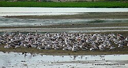
The eastern side of the Coimbatore district, including the city, is predominantly dry. The entire western and northern part of the district borders the Western Ghats with the Nilgiri biosphere as well as the Anaimalai and Munnar ranges. A western pass to Kerala, popularly referred to as the Palghat Gap provides its boundary. Because of its proximity to the Western Ghats, the district is rich in fauna. The Coimbatore urban wetlands harbours around 116 species of birds. Of these, 66 are resident, 17 are migratory and 33 are local migrants.[29] Spot-billed pelican, painted stork, open billed stork, ibis, spot-billed duck, teal, black winged stilt are some of the migratory birds that visit Coimbatore wetlands regularly.[23]
Apart from the species common to the plains, wild elephants, wild boars leopards, tigers, bison, species of deer, Nilgiri tahr, sloth bear and black-headed oriole can be found.[30] The Anamalai Wildlife Sanctuary 88 km (55 mi) in the Western Ghats at an altitude of 1,400 meters covers an area of 958 km2. More than 20% of the district is classified as forest, lying in the west and north. The forests here are abundant in commercially significant trees such as teak, sandalwood, rosewood and bamboo. The Nilgiris slope of the Mettupalayam range is rich in sandalwood trees and bamboo. They vary from rich tropical evergreen forests of Punachi range to jungles of shrubs in southern ranges. Apart from the high altitude regions of Western Ghats, most of the forest area has come under Lantana invasion. The locals refer to it as Siriki Chedi.
The district borders Palakkad district of Kerala in the west, Nilgiris district in the north, Erode district in the northeast and east, Idukki district of Kerala in the south and Dindigul district in the southeast. The district has an area of 7,649 square kilometers. The southwestern and northern parts are hilly, part of the Western Ghats, and enjoys pleasant climate all throughout the year. To the west is the Palghat Gap, the only major pass in the long stretch of the ghats abutting Tamil Nadu and Kerala. The Palghat Gap, connecting Coimbatore city and Palakkad city, serves as an important transit link for both the states. The rest of the district lies in the rain shadow region of the Western Ghats and experiences salubrious climate most parts of the year. The mean maximum and minimum temperatures for Coimbatore city during summer and winter vary between 35 °C to 18 °C.[31] The average annual rainfall in the plains is around 700 mm with the northeast and the southwest monsoons contributing to 47% and 28% respectively to the total rainfall.[31]
The major rivers flowing through the district are Bhavani, Noyyal, Amaravathi, Kousika River and Aliyar. The Siruvani dam is the main source of drinking water for Coimbatore city and is known for its tasty water. Waterfalls in Coimbatore District include Chinnakallar Falls, Monkey Falls, Sengupathi Falls, Siruvani Waterfalls, Thirumoorthy Falls and Vaideki Falls.
Demographics
| Year | Pop. | ±% p.a. |
|---|---|---|
| 1901 | 697,894 | — |
| 1911 | 754,483 | +0.78% |
| 1921 | 787,002 | +0.42% |
| 1931 | 914,515 | +1.51% |
| 1941 | 1,050,676 | +1.40% |
| 1951 | 1,259,135 | +1.83% |
| 1961 | 1,501,084 | +1.77% |
| 1971 | 1,886,146 | +2.31% |
| 1981 | 2,216,562 | +1.63% |
| 1991 | 2,493,715 | +1.19% |
| 2001 | 2,916,620 | +1.58% |
| 2011 | 3,458,045 | +1.72% |
| source:[32] | ||
According to 2011 census, Coimbatore district had a population of 3,458,045 with a sex-ratio of 1,000 females for every 1,000 males, much above the national average of 929.[33] A total of 319,332 were under the age of six, constituting 163,230 males and 156,102 females. Scheduled Castes and Scheduled Tribes accounted for 15.5% and 0.82% of the population respectively. The average literacy of the district was 83.98%.[33] The district had a total of 958,035 households. There were a total of 1,567,950 workers: 75,411 cultivators, 201,351 main agricultural laborers, 44,582 in house hold industries, 1,121,908 other workers, 124,698 marginal workers, 4,806 marginal cultivators, 28,675 marginal agricultural laborers, 5,503 marginal workers in household industries and 85,714 other marginal workers.[34] Tamil is the principal official language and Kongu Tamil, a dialect of Tamil is widely spoken with a small proportion speaking Telugu, Malayalam, Kannada and English. Hindus formed the majority of the population at 90.08% followed by Muslims at 5.33%, Christians at 4.35% and others at 0.24%.[35]
Administrative divisions
Coimbatore district is divided into three revenue blocks, namely, Coimbatore North, Coimbatore South and Pollachi and eleven taluks,[36] viz., Annur, Anaimalai, Coimbatore North taluk, Coimbatore South taluk, Kinathukkadavu, Madukkarai, Mettupalayam, Perur, Pollachi, Sulur and Valparai.
The district is administered by the District collector. The Coimbatore Rural District police is headquartered at Coimbatore headed by Superintendent of police (India). The Coimbatore City Police is headed by a Commissioner of Police in the rank of Inspector General Of Police and is independent of the district police. The district central prison is located in Coimbatore. The district consists of 3 parliamentary constituencies, namely, Coimbatore, Pollachi and Nilgiris. The assembly segments included in the district are, namely, Coimbatore North, Coimbatore South, Kaundampalayam, Singanallur, Sulur, Thondamuthur, Kinathukadavu, Pollachi, Valparai, and Mettuppalayam.
References
- ↑ "2011 Census of India" (MS Excel). Indian government. 16 April 2011.
- ↑ "Manchester of South India". Retrieved 30 August 2015.
- ↑ "Indian Government press release". Press Information Bureau, Government of India. 31 October 2011. Archived from the original on 30 June 2015. Retrieved 31 January 2013.
- ↑ "Coimbatore district, Census 2011". Government of India. Retrieved 30 August 2015.
- ↑ 5.0 5.1 Subramanian, T. S (28 January 2007). "Roman connection in Tamil Nadu". The Hindu. Retrieved 28 October 2011.
- ↑ 6.0 6.1 "Kovai's Roman connection". The Hindu. 8 January 2009. Archived from the original on 25 January 2009. Retrieved 9 June 2010.
- ↑ 7.0 7.1 "On the Roman Trail". The Hindu. 21 January 2008. Archived from the original on 10 November 2012. Retrieved 9 June 2010.
- ↑ 8.0 8.1 Vanavarayar, Shankar (21 June 2010). "Scripting history". The Hindu. Archived from the original on 10 November 2012. Retrieved 9 May 2011.
- ↑ 9.0 9.1 M, Soundariya Preetha (30 June 2007). "Tale of an ancient road". The Hindu. Archived from the original on 3 July 2007. Retrieved 9 May 2011.
- ↑ 10.0 10.1 "The land called Kongunad". The Hindu. 19 November 2005. Archived from the original on 29 March 2006. Retrieved 9 June 2010.
- ↑ 11.0 11.1 "Remembering Dheeran Chinnamalai". The Hindu. 3 August 2007. Archived from the original on 28 March 2008. Retrieved 15 January 2011.
- ↑ 12.0 12.1 "Namma Kovai". The Hindu. 31 December 2013. Retrieved 28 June 2015.
- ↑ 13.0 13.1 "The city that is Coimbatore". The Hindu. 30 April 2005. Archived from the original on 26 July 2011. Retrieved 9 June 2010.
- ↑ 14.0 14.1 S. Muthiah (14 April 2003). "'Golden Tips' in the Nilgiris". The Hindu. Archived from the original on 7 August 2007. Retrieved 9 June 2010.
- ↑ 15.0 15.1 "The cotton classic". Frontline. 30 January 2004. Archived from the original on 29 June 2006. Retrieved 9 June 2010.
- ↑ S. Krishnaswami Aiyangar (2009). Some Contributions of South India to Indian Culture. BiblioBazaar. p. 27. ISBN 978-1-113-17175-7.
- ↑ "Dams and earthquakes". Frontline. 25 December 1999. Archived from the original on 11 August 2010. Retrieved 30 August 2015.
- ↑ "The perils of the past". The Hindu. 28 May 2005. Archived from the original on 10 November 2012. Retrieved 29 December 2010.
- ↑ "Chronicling the spirit of Coimbatore". The Hindu. 3 January 2009. Archived from the original on 10 November 2012. Retrieved 29 December 2010.
- ↑ "The Mahatma's link with Coimbatore". The Hindu. 1 October 2005. Archived from the original on 10 August 2007. Retrieved 9 June 2010.
- ↑ "Keep politics out of Corporation Council". The Hindu. 25 December 2006. Archived from the original on 3 March 2007. Retrieved 9 June 2010.
- ↑ "Coimbatore district - History". Archived from the original on 6 April 2005. Retrieved 30 August 2015.
- ↑ 23.0 23.1 L. Joseph Reginald; C. Mahendran; S. Suresh Kumar; P. Pramod (December 2007). "Birds of Singanallur lake, Coimbatore, Tamil Nadu" (PDF). Zoos' Print Journal. 22 (12): 2944–2948. doi:10.11609/jott.zpj.1657.2944-8.
- ↑ 24.0 24.1 "Business Plan for Coimbatore Corporation" (PDF). Wilbur Smith Associates. Retrieved 9 May 2011.
- ↑ "Noyyal flows on like a quiet killer". Deccan Chronicle. 28 January 2011. Archived from the original on 14 February 2011. Retrieved 9 May 2011.
- ↑ "A river runs through it". The Hindu. 28 January 2006. Archived from the original on 10 November 2012. Retrieved 9 May 2011.
- ↑ "Maintenance of tanks not at cost of environment". The Hindu. 27 October 2010. Archived from the original on 10 November 2012. Retrieved 9 May 2011.
- ↑ "Corporation begins storm water drain project in Coimbatore". The Hindu. 5 January 2011. Archived from the original on 10 January 2011. Retrieved 9 May 2011.
- ↑ "Conservation of bird life". Proceedings of the International Conference on CBEE 2009. World Scientific Publishing Co. Retrieved 9 May 2011.
- ↑ "Coimbatore - a hot spot of bio-diversity". The Hindu. 17 February 2011. Retrieved 9 May 2011.
- ↑ 31.0 31.1 "Coimbatore" (PDF). Government of Tamil Nadu. Archived from the original (PDF) on 13 September 2015. Retrieved 30 August 2015.
- ↑ Decadal Variation In Population Since 1901
- ↑ 33.0 33.1 "Census Info 2011 Final population totals". Office of The Registrar General and Census Commissioner, Ministry of Home Affairs, Government of India. 2013. Retrieved 26 January 2014.
- ↑ "Census Info 2011 Final population totals - Coimbatore district". Office of The Registrar General and Census Commissioner, Ministry of Home Affairs, Government of India. 2013. Retrieved 26 January 2014.
- ↑ "Census on religion". Government of India. Archived from the original on 30 November 2006.
- ↑ Palaniappan, V. S. (5 December 2013). "Government sanctions two new taluks". The Hindu.