




imported>Wikiupdates10 No edit summary |
->ShanKitch mNo edit summary |
||
| Line 2: | Line 2: | ||
{{Use Indian English|date=July 2019}} | {{Use Indian English|date=July 2019}} | ||
{{Infobox road | {{Infobox road | ||
|country=IND | | country = IND | ||
|type = SH | | type = SH | ||
| | | state = Kerala | ||
| | | route = 8 | ||
|map ={{ | | map = {{maplink|frame=yes|plain=yes|frame-align=center|frame-width=300|frame-height=240|type=line|from=State Highway 8 (Kerala).map}} | ||
|map_custom=yes | | map_custom = yes | ||
|map_notes= | | map_notes = SH 8 highlighted in red | ||
| | | spur_type = | ||
|maint = Kerala Public Works Department | | spur_of = | ||
|length_km = 153.6 | | maint = [[Kerala Public Works Department]] | ||
| | | length_km = 153.6 | ||
| | | length_notes = <!--[[Corridor_Name1]]: {{convert|00|km|mi|abbr=on}} (Place1 – Place2)<br />[[Corridor_Name2]]: 00 km (Place1 – Place2) --> | ||
|terminus_a | | established = | ||
| | | allocation = | ||
|direction_b = | | direction_a = South | ||
|terminus_b | | terminus_a = {{jct|state=Kerala|NH|744|country=IND}} in [[Punalur]] <!-- Road begins here. Include Route No. if road starts from another Major route--> | ||
| | | junction = {{plainlist| <!--Use {{plainlist|}}. Only include Primary highways (single & double digit numbered routes) and Inter-state highways. Maximum 10 entries--> | ||
|districts= [[ | * {{jct|state=Kerala|SH|5|country=IND}} in [[Pathanapuram]] | ||
* {{jct|state=Kerala|SH|7|country=IND}} in [[Kumbazha]] | |||
* {{jct|state=Kerala|NH|183A|country=IND}} near [[Pathanamthitta]] | |||
* {{jct|state=Kerala|NH|183|country=IND}} in [[Ponkunnam]] | |||
* {{jct|state=Kerala|SH|32|country=IND}} in [[Pala, Kerala|Pala]] | |||
* {{jct|state=Kerala|SH|42|country=IND}} in [[Karimkunnam, Idukki|Karimkunnam]] | |||
* {{jct|state=Kerala|SH|40|SH|44|SH|33|country=IND}} in [[Thodupuzha]] | |||
}} | |||
| direction_b = North | |||
| terminus_b = {{jct|state=Kerala|SH|1|country=IND}} in [[Muvattupuzha]] <!-- Road ends here. Include Route No. if road ends on another major route--> | |||
| districts = [[Kollam]], [[Pathanamthitta]], [[Kottayam]], [[Idukki]], [[Ernakulam]] | |||
| previous_type = SH | |||
| previous_route = 7 <!-- previous route in road numbering system (SH 4 - SH 5 - SH 6) --> | |||
| next_type = SH | |||
| next_route = 9 <!-- next route in highway numbering system ((SH 4 - SH 5 - SH 6) --> | |||
}} | }} | ||
| Line 32: | Line 46: | ||
It interconnects the townships of Punalur, Pathanapuram, Koodal, Konni, Pathanamthitta, Ranni, Manimala, Ponkunnam, Pala, Thodupuzha to the main intersection at Muvattupuzha merging to [[MC Road]] which extends northwards till [[Angamaly]] at [[NH 66]]. | It interconnects the townships of Punalur, Pathanapuram, Koodal, Konni, Pathanamthitta, Ranni, Manimala, Ponkunnam, Pala, Thodupuzha to the main intersection at Muvattupuzha merging to [[MC Road]] which extends northwards till [[Angamaly]] at [[NH 66]]. | ||
== | == Route description == | ||
Pallimikku Junction (Punalur) (starts from km 44/900 of NH 208) - Pathanapuram - Kallumkadavu Junction (joins SH 05) - Kalanjoor - Koodal - Konni - Kumbazha (Pathanamthitta, meets T.K.Road / SH - 07) - Mylapra - Mannarakulanji - Uthimmoodu - Mandiram - Ranni - Makkapuzha - Ponthanpuzha - Karikkattoor - Manimala - Cheruvally - Ponkunnam - Elamgulam - Pala - Thodupuzha - Vazhakulam - Nirmala College junction - Muvattupuzha(joins MC Road -SH 01) | |||
The economy of the High-Ranges of South and Central Kerala largely depends on the Main Eastern Highway. The main trunk road to [[Sabarimala]], Kerala's Largest Pilgrim Centre starts from Main Eastern Highway near [[Pathanamthitta District|Pathanamthitta]]. Though it is the shortest route to [[Angamaly]] and Northern Kerala townships from [[Punalur]], (The Second Largest City of Kollam District) and in turn from the Tamil Nadu townships [[Tenkasi]], [[Tirunelveli]] and [[Thoothukudi]]. It is not developed to its capacity. It acts as a parallel road to the Main Central Road. (M.C.Road/SH-01). It is also the Shortest route to the Kerala State Capital Thiruvananthapuram from Kumali and other major townships of Idukki district Like Munnar, Kattappana, Thodupuzha, Moolamattam, Nedumkandam etc. | The economy of the High-Ranges of South and Central Kerala largely depends on the Main Eastern Highway. The main trunk road to [[Sabarimala]], Kerala's Largest Pilgrim Centre starts from Main Eastern Highway near [[Pathanamthitta District|Pathanamthitta]]. Though it is the shortest route to [[Angamaly]] and Northern Kerala townships from [[Punalur]], (The Second Largest City of Kollam District) and in turn from the Tamil Nadu townships [[Tenkasi]], [[Tirunelveli]] and [[Thoothukudi]]. It is not developed to its capacity. It acts as a parallel road to the Main Central Road. (M.C.Road/SH-01). It is also the Shortest route to the Kerala State Capital Thiruvananthapuram from Kumali and other major townships of Idukki district Like Munnar, Kattappana, Thodupuzha, Moolamattam, Nedumkandam etc. | ||
=== Townships on the Main Eastern Highway === | |||
The townships [[Punalur]], [[Alimukku]], , [[Pathanapuram]], [[Koodal]], [[Konni, India|Konni]], [[Kumbazha]], [[Ranni]], [[Manimala]], [[Ponkunnam]], [[Palai|Pala]], [[Thodupuzha]], [[Muvattupuzha]] comes under the Main eastern highway road | |||
== KSTP Project == | ==Future== | ||
=== KSTP Project === | |||
The upgrading work of [[Punalur]] -[[Ponkunnam]]-[[Thodupuzha]] stretch is currently under progress as part of the [[World Bank]] funded Kerala State Transport Project (KSTP).<ref>[http://www.thehindu.com/news/cities/Thiruvananthapuram/kstp-phase-ii-work-on-the-slow-lane-in-thiruvananthapuram/article6337873.ece KSTP Phase II work on the slow lane]</ref> | The upgrading work of [[Punalur]] -[[Ponkunnam]]-[[Thodupuzha]] stretch is currently under progress as part of the [[World Bank]] funded Kerala State Transport Project (KSTP).<ref>[http://www.thehindu.com/news/cities/Thiruvananthapuram/kstp-phase-ii-work-on-the-slow-lane-in-thiruvananthapuram/article6337873.ece KSTP Phase II work on the slow lane]</ref> | ||
== References == | == References == | ||
Latest revision as of 07:28, 15 November 2021
 | |
|---|---|
| Route information | |
| Maintained by Kerala Public Works Department | |
| Length | 153.6 km (95.4 mi) |
| Major junctions | |
| South end |  NH 744 in Punalur NH 744 in Punalur |
| |
| North end |  SH 1 in Muvattupuzha SH 1 in Muvattupuzha |
| Location | |
| Country | India |
| State | Kerala |
| Districts | Kollam, Pathanamthitta, Kottayam, Idukki, Ernakulam |
| Highway system | |
| State Highways in Kerala | |
| Lua error in package.lua at line 80: module 'Module:Road data/browsetable' not found. | |


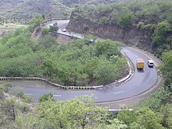
The Main Eastern Highway is the lifeline of the high range townships of the Travancore region of Kerala state, India. It is also known as Punalur-Muvattupuzha Highway. Main Eastern Highway is categorized as State Highway - 08 ( SH-08 ) of Kerala. It is the second longest State Highway of Kerala covering a distance of 153.6 km. The districts it passes through are Kollam, Pathanamthitta, Kottayam, Idukki and Ernakulam.
It interconnects the townships of Punalur, Pathanapuram, Koodal, Konni, Pathanamthitta, Ranni, Manimala, Ponkunnam, Pala, Thodupuzha to the main intersection at Muvattupuzha merging to MC Road which extends northwards till Angamaly at NH 66.
Route description[edit | edit source]
Pallimikku Junction (Punalur) (starts from km 44/900 of NH 208) - Pathanapuram - Kallumkadavu Junction (joins SH 05) - Kalanjoor - Koodal - Konni - Kumbazha (Pathanamthitta, meets T.K.Road / SH - 07) - Mylapra - Mannarakulanji - Uthimmoodu - Mandiram - Ranni - Makkapuzha - Ponthanpuzha - Karikkattoor - Manimala - Cheruvally - Ponkunnam - Elamgulam - Pala - Thodupuzha - Vazhakulam - Nirmala College junction - Muvattupuzha(joins MC Road -SH 01) The economy of the High-Ranges of South and Central Kerala largely depends on the Main Eastern Highway. The main trunk road to Sabarimala, Kerala's Largest Pilgrim Centre starts from Main Eastern Highway near Pathanamthitta. Though it is the shortest route to Angamaly and Northern Kerala townships from Punalur, (The Second Largest City of Kollam District) and in turn from the Tamil Nadu townships Tenkasi, Tirunelveli and Thoothukudi. It is not developed to its capacity. It acts as a parallel road to the Main Central Road. (M.C.Road/SH-01). It is also the Shortest route to the Kerala State Capital Thiruvananthapuram from Kumali and other major townships of Idukki district Like Munnar, Kattappana, Thodupuzha, Moolamattam, Nedumkandam etc.
Townships on the Main Eastern Highway[edit | edit source]
The townships Punalur, Alimukku, , Pathanapuram, Koodal, Konni, Kumbazha, Ranni, Manimala, Ponkunnam, Pala, Thodupuzha, Muvattupuzha comes under the Main eastern highway road
Future[edit | edit source]
KSTP Project[edit | edit source]
The upgrading work of Punalur -Ponkunnam-Thodupuzha stretch is currently under progress as part of the World Bank funded Kerala State Transport Project (KSTP).[1]