

No edit summary |
>Tharun S Kumar m I have added tamil as the official language, which is spoken by more than 80% of kgf people |
||
| Line 1: | Line 1: | ||
{{Use dmy dates|date= | {{Use dmy dates|date=October 2019}} | ||
{{Infobox settlement | {{Infobox settlement | ||
| name = Kolar Gold Fields | | name = Kolar Gold Fields | ||
| other_name = Kolar Gold Mine | | other_name = Kolar Gold Mine | ||
| native_name_lang = | | native_name_lang = Tamizh | ||
| settlement_type = | | settlement_type = | ||
| image_skyline = Champion Reef Mine shaft.jpg | | image_skyline = Champion Reef Mine shaft.jpg | ||
| image_alt = Metal superstructure of a mine shaft, seen through a fence at ground level | | image_alt = Metal superstructure of a mine shaft, seen through a fence at ground level | ||
| image_caption = Champion Reef mine shaft at Kolar Gold Fields | | image_caption = Champion Reef mine shaft at Kolar Gold Fields | ||
| pushpin_map = India Karnataka | |||
| pushpin_label_position = left | |||
| pushpin_map_alt = | |||
| pushpin_map_caption = Location in Karnataka, India | |||
| coordinates = {{coord|12.961736|N|78.270721|E|display=inline,title}} | |||
| subdivision_type = Country | | subdivision_type = Country | ||
| subdivision_name = {{flag|India}} | | subdivision_name = {{flag|India}} | ||
| Line 24: | Line 28: | ||
| area_footnotes = | | area_footnotes = | ||
| area_rank = | | area_rank = | ||
| area_total_km2 = | | area_total_km2 = 58.1234 | ||
| elevation_footnotes = | | elevation_footnotes = | ||
| elevation_m = | | elevation_m = 848 | ||
| population_total = 163,643 | | population_total = 163,643 | ||
| population_as_of = 2011 | | population_as_of = 2011 | ||
| Line 35: | Line 39: | ||
| demographics_type1 = Languages | | demographics_type1 = Languages | ||
| demographics1_title1 = Official | | demographics1_title1 = Official | ||
| demographics1_info1 = Kannada | | demographics1_info1 = Kannada, Tamil | ||
| timezone1 = [[Indian Standard Time|IST]] | | timezone1 = [[Indian Standard Time|IST]] | ||
| utc_offset1 = +5:30 | | utc_offset1 = +5:30 | ||
| Line 46: | Line 50: | ||
| blank1_info_sec1 = | | blank1_info_sec1 = | ||
| blank2_name_sec1 = Nearest city | | blank2_name_sec1 = Nearest city | ||
| blank2_info_sec1 = | | blank2_info_sec1 = [[Kolar]], [[Bangalore]], [[Chikkaballapur]] | ||
| blank3_name_sec1 = [[Lok Sabha]] constituency | | blank3_name_sec1 = [[Lok Sabha]] constituency | ||
| blank3_info_sec1 = [[Kolar]] | | blank3_info_sec1 = [[Kolar]] | ||
| Line 62: | Line 66: | ||
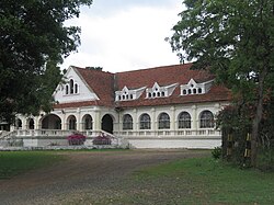
[[File:KGF 008.JPG|thumb|upright=1.2|alt=Exterior of a long, white colonial-style building|KGF Club]] | [[File:KGF 008.JPG|thumb|upright=1.2|alt=Exterior of a long, white colonial-style building|KGF Club]] | ||
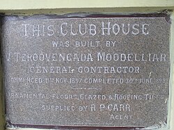
[[File:KGF 005.JPG|thumb|upright=1.2|alt=Grey plaque describing construction of the club house|Plaque at club entrance]] | [[File:KGF 005.JPG|thumb|upright=1.2|alt=Grey plaque describing construction of the club house|Plaque at club entrance]] | ||
[[File:KGF Taluk COVID Map.pdf|thumb|KGF Taluk Map]] | |||
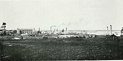
'''Kolar Gold Fields''' ('''K.G.F.''') is a mining region in K.G.F. [[tehsil|taluk]] (township), [[Kolar district]], [[Karnataka]], [[India]]. It is headquartered in [[Robertsonpet]], where employees of [[Bharat Gold Mines Limited]] (BGML) and [[BEML Limited]] (formerly Bharat Earth Movers Limited) and their families live. K.G.F. is about {{convert|30|km}} from [[Kolar]], {{convert| | '''Kolar Gold Fields''' ('''K.G.F.''') is a mining region in K.G.F. [[tehsil|taluk]] (township), [[Kolar district]], [[Karnataka]], [[India]]. It is headquartered in [[Robertsonpet]], where employees of [[Bharat Gold Mines Limited]] (BGML) and [[BEML Limited]] (formerly Bharat Earth Movers Limited) and their families live. K.G.F. is about {{convert|30|km}} from [[Kolar]], {{convert|100|km}} from [[Bangalore]], capital of [[Karnataka]] and 245 kilometers (152 mi) from [[Chennai]], Over a century, the town has been known for gold mining. The mine closed on 28 February 2001 due to a fall in gold prices, despite gold still being present there. One of India's first power-generation units was built in 1889 to support mining operations. The mine complex hosted some [[Particle experiments at Kolar Gold Fields|particle physics experiments]] between the 1960s and 1992. | ||
==History== | ==History== | ||
The early history of the Kolar Gold Fields was compiled by [[Fred Goodwill]], superintendent of the Wesleyan Tamil Mission, [[Bangalore]] and Kolar Gold Fields. Goodwill's studies were published in the ''Quarterly Journal of the [[Daly Memorial Hall|Mythic Society]]'' and elsewhere.<ref name=Mythic>{{cite journal|title=Journal of the Mythic Society|date=1918|volume=9–10|page=iv, 5, 8, 300}}</ref><ref name=Mystic-Nandi>{{cite journal|last1=Goodwill|first1=Fred|title=Nandidroog|journal=The Quarterly Journal of the Mythic Society|date=1918|volume=9–10|page=300|url=https://books.google.com/?id=Mlk4AQAAMAAJ&q | The early history of the Kolar Gold Fields was compiled by [[Fred Goodwill]], superintendent of the Wesleyan Tamil Mission, [[Bangalore]] and Kolar Gold Fields. Goodwill's studies were published in the ''Quarterly Journal of the [[Daly Memorial Hall|Mythic Society]]'' and elsewhere.<ref name=Mythic>{{cite journal|title=Journal of the Mythic Society|date=1918|volume=9–10|page=iv, 5, 8, 300}}</ref><ref name=Mystic-Nandi>{{cite journal|last1=Goodwill|first1=Fred|title=Nandidroog|journal=The Quarterly Journal of the Mythic Society|date=1918|volume=9–10|page=300|url=https://books.google.com/books?id=Mlk4AQAAMAAJ&q=f+goodwill+tamil+bangalore|access-date=27 August 2014}}</ref><ref name="Mining Journal">{{cite journal|last1=Goodwill|first1=Fred|title=The Religious and Military Story of Nudydurga|journal=KGF Mining and Metallurgical Society|date=1921|issue=5|ref=Mining Journal}}</ref> | ||
The [[Western Ganga dynasty|Western Gangas]] founded [[Kolar]] in the second century CE. For as long as they were in power (nearly 1,000 years) they used the title "Kuvalala-Puravareshwara" (Lord of Kolar), even after they moved their capital to [[Talakadu]]. From Talakadu, the Western Gangas ruled Gangavadi (the southern home of the [[Kannada people]]).<ref>{{Cite web|title=Day Before | The [[Western Ganga dynasty|Western Gangas]] founded [[Kolar]] in the second century CE. For as long as they were in power (nearly 1,000 years) they used the title "Kuvalala-Puravareshwara" (Lord of Kolar), even after they moved their capital to [[Talakadu]]. From Talakadu, the Western Gangas ruled Gangavadi (the southern home of the [[Kannada people]]).<ref>{{Cite web|title=Day Before KGF's Release, Bengaluru Court Orders Stay; Producer Says Movie will be Released|url=https://www.news18.com/news/movies/day-before-kgfs-release-bengaluru-court-orders-stay-producer-says-movie-will-be-released-1979401.html|date=2018-12-20|website=News18|access-date=2020-05-17}}</ref> | ||
Kolar came under [[Chola dynasty|Chola rule]] in 1004. Following their usual naming system, the Cholas called the district Nikarilichola-mandala. Around 1117, the [[Hoysala Empire|Hoysalas]] (under [[Vishnuvardhana]]) captured Talakadu and Kolar and drove the Cholas from the [[Kingdom of Mysore]]. [[Vira Someshwara]] divided the empire between his two sons in 1254, and Kolar was given to Ramanatha. | Kolar came under [[Chola dynasty|Chola rule]] in 1004. Following their usual naming system, the Cholas called the district Nikarilichola-mandala. Around 1117, the [[Hoysala Empire|Hoysalas]] (under [[Vishnuvardhana]]) captured Talakadu and Kolar and drove the Cholas from the [[Kingdom of Mysore]]. [[Vira Someshwara]] divided the empire between his two sons in 1254, and Kolar was given to Ramanatha. | ||
The Western Gangas made Kolar their capital and ruled [[Mysore]], [[Coimbatore]], [[Salem, Tamil Nadu|Salem | The Western Gangas made Kolar their capital and ruled [[Mysore]], [[Coimbatore]], [[Salem, Tamil Nadu|Salem]]. Around the 13th century, the sage Pavananthi Munivar wrote ''[[Nannūl|Nannool]]'' about Tamil grammar at the Ulagamadhi cave. | ||
Under Chola rule, King [[Uththama Chola]] is said to have built the temple to [[Renuka]]. The Chola rulers [[Virarajendra Chola|Veera Chola]], [[Vikrama Chola]] and [[Rajendra Chola I|Raja Nagendra Chola]] built stone structures with inscriptions at [[Avani, Kolar|Avani]], [[Mulbagal]], and Sitti Bettta. Chola inscriptions indicate the rule of [[Aditya I|Adithya Chola I]] (871–907), [[Raja Raja Chola I]] and [[Rajendra Chola I]] of Kolar, referring to Kolar as "Nikarili Cholamandalam" and "Jayam Konda Chola Manadalam". Inscriptions of [[Rajendra Chola I]] appear on the [[Kolaramma]] temple. Many Siva temples were built in Kolar under the Cholas, such as the Someshwarar and Sri Uddhandeshwari Temples in the village of Marikuppam, the Eswaran Temple in Oorugaumpet, and the Sivan Temple in the village of Madivala. Chola rule of Kolar lasted until 1116. Chola inscriptions have been neglected and vandalised. According to [[B. Lewis Rice]], names and events have been confused. | Under Chola rule, King [[Uththama Chola]] is said to have built the temple to [[Renuka]]. The Chola rulers [[Virarajendra Chola|Veera Chola]], [[Vikrama Chola]] and [[Rajendra Chola I|Raja Nagendra Chola]] built stone structures with inscriptions at [[Avani, Kolar|Avani]], [[Mulbagal]], and Sitti Bettta. Chola inscriptions indicate the rule of [[Aditya I|Adithya Chola I]] (871–907), [[Raja Raja Chola I]] and [[Rajendra Chola I]] of Kolar, referring to Kolar as "Nikarili Cholamandalam" and "Jayam Konda Chola Manadalam". Inscriptions of [[Rajendra Chola I]] appear on the [[Kolaramma]] temple. Many Siva temples were built in Kolar under the Cholas, such as the Someshwarar and Sri Uddhandeshwari Temples in the village of Marikuppam, the Eswaran Temple in Oorugaumpet, and the Sivan Temple in the village of Madivala. Chola rule of Kolar lasted until 1116. Chola inscriptions have been neglected and vandalised. According to [[B. Lewis Rice]], names and events have been confused. | ||
| Line 78: | Line 82: | ||
[[Vijayanagara Empire|Vijaynagar]] rule of Kolar lasted from 1336 to 1664. During the 17th century, Kolar came under [[Maratha Empire|Maratha]] rule as part of the [[jagir]] of [[Shahaji]] for fifty years before it was ruled by the Muslims for seventy years. In 1720, Kolar became part of the [[province of Sira]]; [[Fath Muhammad]], the father of [[Hyder Ali]], was [[faujdar]] of the province. Kolar was then ruled by the [[Maratha Empire|Marathas]], the Nawab of [[Kadapa|Cuddapah]], the [[Nizam of Hyderabad]], and [[Hyder Ali]]. Ruled by the [[British Raj|British]] from 1768 to 1770, it passed again to the Marathas and then to [[Hyder Ali]]. In 1791, [[Charles Cornwallis, 1st Marquess Cornwallis|Lord Cornwallis]] conquered Kolar in 1791, returning it again to [[Mysore State|Mysore]] in the [[Treaty of Seringapatam]] the following year. | [[Vijayanagara Empire|Vijaynagar]] rule of Kolar lasted from 1336 to 1664. During the 17th century, Kolar came under [[Maratha Empire|Maratha]] rule as part of the [[jagir]] of [[Shahaji]] for fifty years before it was ruled by the Muslims for seventy years. In 1720, Kolar became part of the [[province of Sira]]; [[Fath Muhammad]], the father of [[Hyder Ali]], was [[faujdar]] of the province. Kolar was then ruled by the [[Maratha Empire|Marathas]], the Nawab of [[Kadapa|Cuddapah]], the [[Nizam of Hyderabad]], and [[Hyder Ali]]. Ruled by the [[British Raj|British]] from 1768 to 1770, it passed again to the Marathas and then to [[Hyder Ali]]. In 1791, [[Charles Cornwallis, 1st Marquess Cornwallis|Lord Cornwallis]] conquered Kolar in 1791, returning it again to [[Mysore State|Mysore]] in the [[Treaty of Seringapatam]] the following year. | ||
Inscriptions in the region indicate the reign of Mahavalis (Baanaas), Kadambas, Chalukyas, Pallava, Vaidumbaas, Rastrakutas, Cholas, Hoysalas and Mysore kings.<ref name=Mythic /><ref name=Mystic-Nandi /><ref name="Mining Journal" /><ref name=Srikumar>{{cite book|last1=Srikumar|first1=S|title=Kolar Gold Field: (Unfolding the Untold)|date=12 March 2014|publisher=Partridge Publishing|isbn=978-1482815078|pages=40–46|edition=International|url=https://books.google.com/?id=QrWEAwAAQBAJ& | Inscriptions in the region indicate the reign of Mahavalis (Baanaas), Kadambas, Chalukyas, Pallava, Vaidumbaas, Rastrakutas, Cholas, Hoysalas and Mysore kings.<ref name=Mythic /><ref name=Mystic-Nandi /><ref name="Mining Journal" /><ref name=Srikumar>{{cite book|last1=Srikumar|first1=S|title=Kolar Gold Field: (Unfolding the Untold)|date=12 March 2014|publisher=Partridge Publishing|isbn=978-1482815078|pages=40–46|edition=International|url=https://books.google.com/books?id=QrWEAwAAQBAJ&q=f+goodwill+tamil+bangalore&pg=PA40|access-date=27 August 2014}}</ref><ref name="Gayatri">{{cite book|last1=Chandrashekar|first1=Gayatri|title=Grit and Gold|date=2015|publisher=Partridge Publishing|isbn=9781482855845|url=https://books.google.com/books?id=ZV50CgAAQBAJ&q=Rev+Goodwill+Tamil&pg=PT22|access-date=11 July 2016}}</ref> B. Lewis Rice recorded 1,347 inscriptions in the district in the 10th volume of ''[[Epigraphia Carnatica]]''. Of the inscriptions, 714 are in [[Kannada]];<ref name=RiceX>{{cite book|last1=Rice|first1=Benjamin Lewis|title=Epigraphia Carnatica: Volume X: Inscriptions in the Kolar District|date=1994|publisher=Department of Archaeology, Mysore State|location=[[Mangalore]], [[United Kingdom|British]] India|url=https://archive.org/stream/epigraphiacarnat10myso#page/n7/mode/2up|access-date=4 August 2015|page=i}}</ref> 422 are in [[Tamil language|Tamil]], and 211 in [[Telugu language|Telugu]]. | ||
John Taylor III acquired a number of mines in K.G.F. in 1880, and his firm (John Taylor & Sons) operated them until 1956; the Mysore Gold Mining Company was a subsidiary. In 1902, the mines were electrified with a {{convert|140|km|adj=on}} cable run by [[General Electric]] from the hydroelectric power plant at [[Shivanasamudra Falls]].<ref name=Meera>{{cite news|last1=Iyer|first1=Meera|title=Miscellany - A time capsule|url=http://www.deccanherald.com/content/490415/miscellany-time-capsule.html| | John Taylor III acquired a number of mines in K.G.F. in 1880, and his firm (John Taylor & Sons) operated them until 1956; the Mysore Gold Mining Company was a subsidiary. In 1902, the mines were electrified with a {{convert|140|km|adj=on}} cable run by [[General Electric]] from the hydroelectric power plant at [[Shivanasamudra Falls]].<ref name=Meera>{{cite news|last1=Iyer|first1=Meera|title=Miscellany - A time capsule|url=http://www.deccanherald.com/content/490415/miscellany-time-capsule.html|access-date=7 August 2015|issue=Bangalore|publisher=Deccan Herald|date=21 June 2015}}</ref> The government of Mysore took over the mines in 1956. | ||
=={{anchor|Birth of the city|In popular culture}}Origin of the city== | =={{anchor|Birth of the city|In popular culture}}Origin of the city== | ||
With the growth of the gold mines requiring more labour, people from the [[Dharmapuri district|Dharmapuri]], [[Krishnagiri district|Krishnagiri]], [[Salem district|Salem]] and [[North Arcot|North]] and [[South Arcot District (Madras Presidency)|South Arcot]] districts of [[Tamil Nadu]] and the [[Chittoor district|Chittoor]] and [[Anantapur district|Ananthapur]] districts of [[Andhra Pradesh]] settled nearby;<ref>{{Cite web|title='KGF' team recreated gold mines from 70's at Real Kolar Gold Field - Times of India|url=https://timesofindia.indiatimes.com/entertainment/kannada/movies/news/kgf-team-recreated-gold-mines-from-70s-at-real-kolar-gold-field/articleshow/66696105.cms|website=The Times of India|language=en|access-date=2020-05-17}}</ref> the settlements began to form the outskirts of K.G.F. The well-to-do families of British and Indian engineers, geologists, and mine supervisors lived in the centre of town. Two townships, Robertsonpet and Andersonpet, are named after two British mine officials. | With the growth of the gold mines requiring more labour, people from the [[Dharmapuri district|Dharmapuri]], [[Krishnagiri district|Krishnagiri]], [[Salem district|Salem]] and [[North Arcot|North]] and [[South Arcot District (Madras Presidency)|South Arcot]] districts of [[Tamil Nadu]] and the [[Chittoor district|Chittoor]] and [[Anantapur district|Ananthapur]] districts of [[Andhra Pradesh]] settled nearby;<ref>{{Cite web|title='KGF' team recreated gold mines from 70's at Real Kolar Gold Field - Times of India|url=https://timesofindia.indiatimes.com/entertainment/kannada/movies/news/kgf-team-recreated-gold-mines-from-70s-at-real-kolar-gold-field/articleshow/66696105.cms|website=The Times of India|language=en|access-date=2020-05-17}}</ref> the settlements began to form the outskirts of K.G.F. The well-to-do families of British and Indian engineers, geologists, and mine supervisors lived in the centre of town. Two townships, Robertsonpet and Andersonpet, are named after two British mine officials. | ||
The establishment of [[BEML Limited]] expanded the city, providing employment and attracting new residents. The Kannada-language blockbuster film ''[[K.G.F: Chapter 1]]'' and its sequel, ''[[K.G.F: Chapter 2]]'', are set there.<ref>{{cite web |title= The Story of KGF: Cradle of India's Gold Rush |url=https://www.thequint.com/news/india/the-real-story-of-kgf-cradle-of-indias-gold-rush |publisher= [[The Quint]] | | The establishment of [[BEML Limited]] expanded the city, providing employment and attracting new residents. The Kannada-language blockbuster film ''[[K.G.F: Chapter 1]]'' and its sequel, ''[[K.G.F: Chapter 2]]'', are set there.<ref>{{cite web |title= The Story of KGF: Cradle of India's Gold Rush |url=https://www.thequint.com/news/india/the-real-story-of-kgf-cradle-of-indias-gold-rush |publisher= [[The Quint]] |access-date=3 April 2019|date=20 December 2018 }}</ref> | ||
=={{anchor|Kolar National Geological Monument|Pyroclastics & Pillow lavas of Kolar Gold fields}}National geological monument== | =={{anchor|Kolar National Geological Monument|Pyroclastics & Pillow lavas of Kolar Gold fields}}National geological monument== | ||
| Line 92: | Line 96: | ||
==Demographics== | ==Demographics== | ||
The official language is [[Kannada]], but Tamil and Telugu are also spoken widely.<ref>{{cite web|url=http://www.censusindia.gov.in/2011Census/Language_MTs.html|title=Data on Language and Mother Tongue|website=Censusindia.gov.in| | The official language is [[Kannada]], but Tamil and Telugu are also spoken widely.<ref>{{cite web|url=http://www.censusindia.gov.in/2011Census/Language_MTs.html|title=Data on Language and Mother Tongue|website=Censusindia.gov.in|access-date=25 August 2018}}</ref> Most of the Tamil population trace their ancestry to labourers brought by the British from the [[North Arcot]], [[Chittoor]], [[Salem, Tamil Nadu|Salem]] and [[Dharmapuri]] districts of the [[Madras Presidency]] during the late 19th century.<ref name=Srikumar /><ref name=Blog>{{cite web|title=Kolar Gold Fields: Land with Golden People|url=http://kolargoldfieldsindia.blogspot.com.au/|publisher=Blogspot|access-date=6 January 2015}}</ref><ref name=Arul>{{cite web|last1=Steve|first1=Arul|title=Specialization On Social And Cultural Indifference Among KGF Tamil Migrants|url=https://arulsteve736.wordpress.com/2013/04/17/specialization-on-social-and-cultural-indifference-among-kgf-tamil-migrants/|website=ArulSteve736|publisher=Word Press|access-date=6 January 2015|date=April 2013}}</ref> Substantial Anglo-Indian and [[Arcot Mudaliar]] populations are descendants of mine supervisors.<ref name=Bridget/> | ||
=={{anchor|Closing of Kolar Gold Mines}}Mine closures== | =={{anchor|Closing of Kolar Gold Mines}}Mine closures== | ||
The Kolar gold mines were nationalized in 1956, and provided a total of over 900 tonnes of [[gold]]. They were closed by the Indian government on 28 February 2001 for environmental and economic reasons; food, water and shelter were scarce, and production did not justify the investment.<ref>{{Cite web|url=http://memoriesofkgf.blogspot.com/2014/11/some-important-dates-in-history-of.html|title=Kolar Gold Fields - Nostalgia: Some Important Dates in the History of Kolar Gold Fields|last=White-kumar|first=Bridget|date=2014-11-21|website=Kolar Gold Fields - Nostalgia|access-date=2019-12-22}}</ref><ref>{{Cite web|url=https://timesofindia.indiatimes.com/city/bengaluru/old-kgf-mines-can-never-be-reopened/articleshow/57115320.cms|title=Old KGF mines can never be reopened {{!}} Bengaluru News - Times of India| | The Kolar gold mines were nationalized in 1956, and provided a total of over 900 tonnes of [[gold]]. They were closed by the Indian government on 28 February 2001 for environmental and economic reasons; food, water and shelter were scarce, and production did not justify the investment.<ref>{{Cite web|url=http://memoriesofkgf.blogspot.com/2014/11/some-important-dates-in-history-of.html|title=Kolar Gold Fields - Nostalgia: Some Important Dates in the History of Kolar Gold Fields|last=White-kumar|first=Bridget|date=2014-11-21|website=Kolar Gold Fields - Nostalgia|access-date=2019-12-22}}</ref><ref>{{Cite web|url=https://timesofindia.indiatimes.com/city/bengaluru/old-kgf-mines-can-never-be-reopened/articleshow/57115320.cms|title=Old KGF mines can never be reopened {{!}} Bengaluru News - Times of India|last1=Feb 13|first1=TNN {{!}}|last2=2017|website=The Times of India|language=en|access-date=2019-12-22|last3=Ist|first3=0:30}}</ref> | ||
==Education== | |||
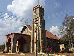
[[File:St. Michael's and All Angels' Church, Oorgaum, KGF.jpg|thumb|upright=1.2|alt=Exterior of a stone church|[[St. Michael's and All Angels' Church, Oorgaum, KGF|St. Michael's and All Angels' Church]]]] | |||
In 1901, an English-language primary school was founded by John Taylor and Sons at the Nandydoorg Mine to educate the children of British and European employees. It became known as the [[Kolar Gold Fields Boys School]], and was upgraded to a middle and high school; students took the [[Senior Cambridge]] examinations. The school was co-educational at the primary level. | |||
On 15 January 1904, the Sisters of St. Joseph of Tarbes founded an English-language school for Europeans and Anglo-Indians for 22 girls. St. Mary's Boys School was also founded. The boys' school later moved to [[Andersonpet]]. | |||
In 1933, the Order of the St. Joseph of Tarbes founded St. Theresa's School in [[Robertsonpet]]; St. Sebastian's School was founded in Coromandel a decade later. Both schools offered English lessons.<ref name=Bridget>{{cite book|last1=White|first1=Bridget|title=Kolar Gold Fields - Down Memory Lane: Paeans to Lost Glory!|date=2010|publisher=Author House|location=Central Milton Keynes|isbn=978-1452051031|url=https://books.google.com/books?id=2iFRgQXTbeAC&q=tamil+population+in+KGF|access-date=6 January 2015}}</ref> To educate the growing [[Marwari people|Marwari]] population, the Sumathi Jain High School was founded in Robertsonpet.<ref name=Deccan>{{cite news|last1=White|first1=Bridget|title=Tale of two thriving townships|url=http://www.deccanherald.com/content/113032/tale-two-thriving-townships.html|access-date=13 January 2015|issue=Bangalore|publisher=Deccan Herald|date=15 November 2010}}</ref> K.G.F. has several colleges, including the KGF College of Dental Science and Hospital, the [[Dr. T. Thimmaiah Institute of Technology]], and the Sri Kengal Hanumanthaiya Law College, Don Bosco Technical Institute. | |||
==Climate== | ==Climate== | ||
| Line 197: | Line 210: | ||
|source 1 = [[India Meteorological Department]]<ref name=IMDnormals> | |source 1 = [[India Meteorological Department]]<ref name=IMDnormals> | ||
{{cite web | {{cite web | ||
| | | archive-url = https://web.archive.org/web/20200205040301/http://imdpune.gov.in/library/public/1981-2010%20CLIM%20NORMALS%20%28STATWISE%29.pdf | ||
| | | archive-date = 5 February 2020 | ||
| url = | | url = https://imdpune.gov.in/library/public/1981-2010%20CLIM%20NORMALS%20%28STATWISE%29.pdf | ||
| title = Station: Kolar Gold Field Climatological Table 1981–2010 | | title = Station: Kolar Gold Field Climatological Table 1981–2010 | ||
| work = Climatological Normals 1981–2010 | | work = Climatological Normals 1981–2010 | ||
| Line 205: | Line 218: | ||
| date = January 2015 | | date = January 2015 | ||
| pages = 421–422 | | pages = 421–422 | ||
| | | access-date = 19 April 2020}}</ref><ref name=IMDextremes> | ||
{{cite web | {{cite web | ||
| | | archive-url = https://web.archive.org/web/20200205042509/http://imdpune.gov.in/library/public/EXTREMES%20OF%20TEMPERATURE%20and%20RAINFALL%20upto%202012.pdf | ||
| | | archive-date = 5 February 2020 | ||
| url = | | url = https://imdpune.gov.in/library/public/EXTREMES%20OF%20TEMPERATURE%20and%20RAINFALL%20upto%202012.pdf | ||
| title = Extremes of Temperature & Rainfall for Indian Stations (Up to 2012) | | title = Extremes of Temperature & Rainfall for Indian Stations (Up to 2012) | ||
| publisher = India Meteorological Department | | publisher = India Meteorological Department | ||
| date = December 2016 | | date = December 2016 | ||
| page = M98 | | page = M98 | ||
| | | access-date = 19 April 2020}}</ref> | ||
}} | }} | ||
== | ==See also== | ||
[[ | * [[Hutti Gold Mines Limited]] | ||
* [[Kolar (Lok Sabha constituency)]] | |||
* [[K.G.F: Chapter 1|K.G.F: The movie]] | |||
==References== | ==References== | ||
| Line 229: | Line 239: | ||
==External links== | ==External links== | ||
{{Commons category}} | |||
*[https://pad.ma/grid/title/project==Kolar_Gold_Fields_and_Mines Kolar Gold Fields archival video with annotations] | *[https://pad.ma/grid/title/project==Kolar_Gold_Fields_and_Mines Kolar Gold Fields archival video with annotations] | ||
*[https://web.archive.org/web/20081105235128/http://www.kolarcity.gov.in/tourism.html Kolar tourism] | *[https://web.archive.org/web/20081105235128/http://www.kolarcity.gov.in/tourism.html Kolar tourism] | ||
*{{PM20|FID=co/053274|TEXT=Documents and clippings about|NAME=Champion Reef Gold}} | |||
*https://kgfarchives.wordpress.com/blog/ | |||
{{Authority control}} | |||
[[Category:Cities and towns in Kolar district]] | [[Category:Cities and towns in Kolar district]] | ||
Revision as of 21:20, 11 July 2021
Kolar Gold Fields
Kolar Gold Mine | |
|---|---|
 Champion Reef mine shaft at Kolar Gold Fields | |
  Kolar Gold Fields Location in Karnataka, India | |
| Coordinates: 12°57′42″N 78°16′15″E / 12.961736°N 78.270721°E | |
| Country |  India India |
| State | Karnataka |
| District | Kolar district |
| Government | |
| • Body | Robertsonpet Municipal Council |
| Area | |
| • Total | 58.1234 km2 (22.4416 sq mi) |
| Elevation | 848 m (2,782 ft) |
| Population (2011) | |
| • Total | 163,643 |
| • Density | 2,800/km2 (7,300/sq mi) |
| Languages | |
| • Official | Kannada, Tamil |
| Time zone | UTC+5:30 (IST) |
| PIN | 563115 -563122 |
| Telephone code | 08153 |
| Vehicle registration | KA 08 |
| Nearest city | Kolar, Bangalore, Chikkaballapur |
| Lok Sabha constituency | Kolar |
| Vidhan Sabha constituency | K.G.F. |
| Avg. summer temperature | 32 °C (90 °F) |
| Avg. winter temperature | 12 °C (54 °F) |
| Website | http://www.robertsonpetcity.gov.in |


Kolar Gold Fields (K.G.F.) is a mining region in K.G.F. taluk (township), Kolar district, Karnataka, India. It is headquartered in Robertsonpet, where employees of Bharat Gold Mines Limited (BGML) and BEML Limited (formerly Bharat Earth Movers Limited) and their families live. K.G.F. is about 30 kilometres (19 mi) from Kolar, 100 kilometres (62 mi) from Bangalore, capital of Karnataka and 245 kilometers (152 mi) from Chennai, Over a century, the town has been known for gold mining. The mine closed on 28 February 2001 due to a fall in gold prices, despite gold still being present there. One of India's first power-generation units was built in 1889 to support mining operations. The mine complex hosted some particle physics experiments between the 1960s and 1992.
History
The early history of the Kolar Gold Fields was compiled by Fred Goodwill, superintendent of the Wesleyan Tamil Mission, Bangalore and Kolar Gold Fields. Goodwill's studies were published in the Quarterly Journal of the Mythic Society and elsewhere.[1][2][3]
The Western Gangas founded Kolar in the second century CE. For as long as they were in power (nearly 1,000 years) they used the title "Kuvalala-Puravareshwara" (Lord of Kolar), even after they moved their capital to Talakadu. From Talakadu, the Western Gangas ruled Gangavadi (the southern home of the Kannada people).[4]
Kolar came under Chola rule in 1004. Following their usual naming system, the Cholas called the district Nikarilichola-mandala. Around 1117, the Hoysalas (under Vishnuvardhana) captured Talakadu and Kolar and drove the Cholas from the Kingdom of Mysore. Vira Someshwara divided the empire between his two sons in 1254, and Kolar was given to Ramanatha.
The Western Gangas made Kolar their capital and ruled Mysore, Coimbatore, Salem. Around the 13th century, the sage Pavananthi Munivar wrote Nannool about Tamil grammar at the Ulagamadhi cave.
Under Chola rule, King Uththama Chola is said to have built the temple to Renuka. The Chola rulers Veera Chola, Vikrama Chola and Raja Nagendra Chola built stone structures with inscriptions at Avani, Mulbagal, and Sitti Bettta. Chola inscriptions indicate the rule of Adithya Chola I (871–907), Raja Raja Chola I and Rajendra Chola I of Kolar, referring to Kolar as "Nikarili Cholamandalam" and "Jayam Konda Chola Manadalam". Inscriptions of Rajendra Chola I appear on the Kolaramma temple. Many Siva temples were built in Kolar under the Cholas, such as the Someshwarar and Sri Uddhandeshwari Temples in the village of Marikuppam, the Eswaran Temple in Oorugaumpet, and the Sivan Temple in the village of Madivala. Chola rule of Kolar lasted until 1116. Chola inscriptions have been neglected and vandalised. According to B. Lewis Rice, names and events have been confused.
Vijaynagar rule of Kolar lasted from 1336 to 1664. During the 17th century, Kolar came under Maratha rule as part of the jagir of Shahaji for fifty years before it was ruled by the Muslims for seventy years. In 1720, Kolar became part of the province of Sira; Fath Muhammad, the father of Hyder Ali, was faujdar of the province. Kolar was then ruled by the Marathas, the Nawab of Cuddapah, the Nizam of Hyderabad, and Hyder Ali. Ruled by the British from 1768 to 1770, it passed again to the Marathas and then to Hyder Ali. In 1791, Lord Cornwallis conquered Kolar in 1791, returning it again to Mysore in the Treaty of Seringapatam the following year.
Inscriptions in the region indicate the reign of Mahavalis (Baanaas), Kadambas, Chalukyas, Pallava, Vaidumbaas, Rastrakutas, Cholas, Hoysalas and Mysore kings.[1][2][3][5][6] B. Lewis Rice recorded 1,347 inscriptions in the district in the 10th volume of Epigraphia Carnatica. Of the inscriptions, 714 are in Kannada;[7] 422 are in Tamil, and 211 in Telugu.
John Taylor III acquired a number of mines in K.G.F. in 1880, and his firm (John Taylor & Sons) operated them until 1956; the Mysore Gold Mining Company was a subsidiary. In 1902, the mines were electrified with a 140-kilometre (87 mi) cable run by General Electric from the hydroelectric power plant at Shivanasamudra Falls.[8] The government of Mysore took over the mines in 1956.
Origin of the city
With the growth of the gold mines requiring more labour, people from the Dharmapuri, Krishnagiri, Salem and North and South Arcot districts of Tamil Nadu and the Chittoor and Ananthapur districts of Andhra Pradesh settled nearby;[9] the settlements began to form the outskirts of K.G.F. The well-to-do families of British and Indian engineers, geologists, and mine supervisors lived in the centre of town. Two townships, Robertsonpet and Andersonpet, are named after two British mine officials.
The establishment of BEML Limited expanded the city, providing employment and attracting new residents. The Kannada-language blockbuster film K.G.F: Chapter 1 and its sequel, K.G.F: Chapter 2, are set there.[10]
National geological monument
The pyroclastic and pillow lava at Kolar Gold Fields have been declared a National Geological Monument by the Geological Survey of India (GSI) for their protection, maintenance, and encouragement of geotourism.[11][12][13]
Demographics
The official language is Kannada, but Tamil and Telugu are also spoken widely.[14] Most of the Tamil population trace their ancestry to labourers brought by the British from the North Arcot, Chittoor, Salem and Dharmapuri districts of the Madras Presidency during the late 19th century.[5][15][16] Substantial Anglo-Indian and Arcot Mudaliar populations are descendants of mine supervisors.[17]
Mine closures
The Kolar gold mines were nationalized in 1956, and provided a total of over 900 tonnes of gold. They were closed by the Indian government on 28 February 2001 for environmental and economic reasons; food, water and shelter were scarce, and production did not justify the investment.[18][19]
Education

In 1901, an English-language primary school was founded by John Taylor and Sons at the Nandydoorg Mine to educate the children of British and European employees. It became known as the Kolar Gold Fields Boys School, and was upgraded to a middle and high school; students took the Senior Cambridge examinations. The school was co-educational at the primary level.
On 15 January 1904, the Sisters of St. Joseph of Tarbes founded an English-language school for Europeans and Anglo-Indians for 22 girls. St. Mary's Boys School was also founded. The boys' school later moved to Andersonpet.
In 1933, the Order of the St. Joseph of Tarbes founded St. Theresa's School in Robertsonpet; St. Sebastian's School was founded in Coromandel a decade later. Both schools offered English lessons.[17] To educate the growing Marwari population, the Sumathi Jain High School was founded in Robertsonpet.[20] K.G.F. has several colleges, including the KGF College of Dental Science and Hospital, the Dr. T. Thimmaiah Institute of Technology, and the Sri Kengal Hanumanthaiya Law College, Don Bosco Technical Institute.
Climate
| Climate data for Kolar Gold Fields (1981–2010, extremes 1972–2002) | |||||||||||||
|---|---|---|---|---|---|---|---|---|---|---|---|---|---|
| Month | Jan | Feb | Mar | Apr | May | Jun | Jul | Aug | Sep | Oct | Nov | Dec | Year |
| Record high °C (°F) | 33.9 (93.0) |
35.1 (95.2) |
38.3 (100.9) |
39.7 (103.5) |
38.2 (100.8) |
38.5 (101.3) |
34.5 (94.1) |
33.4 (92.1) |
33.7 (92.7) |
32.5 (90.5) |
31.1 (88.0) |
29.9 (85.8) |
39.7 (103.5) |
| Average high °C (°F) | 26.4 (79.5) |
29.6 (85.3) |
32.5 (90.5) |
34.1 (93.4) |
34.0 (93.2) |
30.8 (87.4) |
29.6 (85.3) |
29.0 (84.2) |
29.3 (84.7) |
27.8 (82.0) |
26.3 (79.3) |
25.1 (77.2) |
29.5 (85.1) |
| Average low °C (°F) | 15.0 (59.0) |
16.4 (61.5) |
18.7 (65.7) |
21.3 (70.3) |
21.7 (71.1) |
20.6 (69.1) |
20.1 (68.2) |
19.8 (67.6) |
19.7 (67.5) |
19.2 (66.6) |
17.5 (63.5) |
15.8 (60.4) |
18.8 (65.8) |
| Record low °C (°F) | 10.0 (50.0) |
10.5 (50.9) |
12.4 (54.3) |
15.7 (60.3) |
17.5 (63.5) |
15.4 (59.7) |
17.3 (63.1) |
17.1 (62.8) |
16.2 (61.2) |
13.6 (56.5) |
12.0 (53.6) |
9.4 (48.9) |
9.4 (48.9) |
| Average rainfall mm (inches) | 3.5 (0.14) |
3.7 (0.15) |
19.4 (0.76) |
34.6 (1.36) |
98.4 (3.87) |
77.9 (3.07) |
81.7 (3.22) |
104.6 (4.12) |
212.4 (8.36) |
138.9 (5.47) |
76.7 (3.02) |
27.2 (1.07) |
879.1 (34.61) |
| Average rainy days | 0.3 | 0.4 | 1.2 | 2.4 | 5.5 | 3.9 | 4.9 | 6.3 | 8.0 | 7.4 | 5.1 | 2.2 | 47.6 |
| Average relative humidity (%) (at 17:30 IST) | 49 | 37 | 32 | 38 | 48 | 56 | 58 | 61 | 63 | 68 | 67 | 63 | 54 |
| Source: India Meteorological Department[21][22] | |||||||||||||
See also
References
- ↑ 1.0 1.1 "Journal of the Mythic Society". 9–10. 1918: iv, 5, 8, 300.
{{cite journal}}: Cite journal requires|journal=(help) - ↑ 2.0 2.1 Goodwill, Fred (1918). "Nandidroog". The Quarterly Journal of the Mythic Society. 9–10: 300. Retrieved 27 August 2014.
- ↑ 3.0 3.1 Goodwill, Fred (1921). "The Religious and Military Story of Nudydurga". KGF Mining and Metallurgical Society (5).
- ↑ "Day Before KGF's Release, Bengaluru Court Orders Stay; Producer Says Movie will be Released". News18. 20 December 2018. Retrieved 17 May 2020.
- ↑ 5.0 5.1 Srikumar, S (12 March 2014). Kolar Gold Field: (Unfolding the Untold) (International ed.). Partridge Publishing. pp. 40–46. ISBN 978-1482815078. Retrieved 27 August 2014.
- ↑ Chandrashekar, Gayatri (2015). Grit and Gold. Partridge Publishing. ISBN 9781482855845. Retrieved 11 July 2016.
- ↑ Rice, Benjamin Lewis (1994). Epigraphia Carnatica: Volume X: Inscriptions in the Kolar District. Mangalore, British India: Department of Archaeology, Mysore State. p. i. Retrieved 4 August 2015.
- ↑ Iyer, Meera (21 June 2015). "Miscellany - A time capsule". No. Bangalore. Deccan Herald. Retrieved 7 August 2015.
- ↑ "'KGF' team recreated gold mines from 70's at Real Kolar Gold Field - Times of India". The Times of India. Retrieved 17 May 2020.
- ↑ "The Story of KGF: Cradle of India's Gold Rush". The Quint. 20 December 2018. Retrieved 3 April 2019.
- ↑ "National Geological Monument, from Geological Survey of India website". Archived from the original on 12 July 2017. Retrieved 21 January 2019.
- ↑ "Geo-Heritage Sites". pib.nic.in. Press Information Bureau. 9 March 2016. Retrieved 15 September 2018.
- ↑ national geo-heritage of India, INTACH
- ↑ "Data on Language and Mother Tongue". Censusindia.gov.in. Retrieved 25 August 2018.
- ↑ "Kolar Gold Fields: Land with Golden People". Blogspot. Retrieved 6 January 2015.
- ↑ Steve, Arul (April 2013). "Specialization On Social And Cultural Indifference Among KGF Tamil Migrants". ArulSteve736. Word Press. Retrieved 6 January 2015.
- ↑ 17.0 17.1 White, Bridget (2010). Kolar Gold Fields - Down Memory Lane: Paeans to Lost Glory!. Central Milton Keynes: Author House. ISBN 978-1452051031. Retrieved 6 January 2015.
- ↑ White-kumar, Bridget (21 November 2014). "Kolar Gold Fields - Nostalgia: Some Important Dates in the History of Kolar Gold Fields". Kolar Gold Fields - Nostalgia. Retrieved 22 December 2019.
- ↑ Feb 13, TNN |; 2017; Ist, 0:30. "Old KGF mines can never be reopened | Bengaluru News - Times of India". The Times of India. Retrieved 22 December 2019.
{{cite web}}:|last2=has numeric name (help)CS1 maint: numeric names: authors list (link) - ↑ White, Bridget (15 November 2010). "Tale of two thriving townships". No. Bangalore. Deccan Herald. Retrieved 13 January 2015.
- ↑ "Station: Kolar Gold Field Climatological Table 1981–2010" (PDF). Climatological Normals 1981–2010. India Meteorological Department. January 2015. pp. 421–422. Archived from the original (PDF) on 5 February 2020. Retrieved 19 April 2020.
- ↑ "Extremes of Temperature & Rainfall for Indian Stations (Up to 2012)" (PDF). India Meteorological Department. December 2016. p. M98. Archived from the original (PDF) on 5 February 2020. Retrieved 19 April 2020.