


robot: Update article (please report if you notice any mistake or error in this edit) |
m updated page |
||
| Line 1: | Line 1: | ||
{{About|a suburban area|other uses}} | {{About|a suburban area|other uses}} | ||
{{Use dmy dates|date=January | {{more citations needed|date=November 2024}} | ||
{{Use Indian English|date=January | {{Use dmy dates|date=January 2024}} | ||
{{Use Indian English|date=January 2024}} | |||
{{Infobox settlement | {{Infobox settlement | ||
| name = Malkajgiri | | name = Malkajgiri | ||
| other_name = Mallikarjuna Giri | |||
| other_name = | |settlement_type = [[Suburb]], GHMC Circle, '''Sub-District''' | ||
|settlement_type = [[Suburb]],GHMC | |||
| image_skyline = Malkajgiri-x-road.jpg | | image_skyline = Malkajgiri-x-road.jpg | ||
| image_caption = Malkajgiri 'x' Roads | | image_caption = Malkajgiri 'x' Roads | ||
| pushpin_map = India Telangana#India | | pushpin_map = India Telangana#India | ||
| pushpin_map_caption = | | pushpin_map_caption = Malkajgiri ([[Telangana]]) | ||
| coordinates = {{coord|17| | | coordinates = {{coord|17|27|01.1|N|78|31|55.9|E|display=inline,title}} | ||
| subdivision_type = Country | | subdivision_type = [[Country]] | ||
| subdivision_name = {{flag|India}} | | subdivision_name = {{flag|India}} | ||
| subdivision_type1 = [[States and territories of India|State]] | | subdivision_type1 = [[States and territories of India|State]] | ||
| subdivision_type2 = [[List of districts of India|District]] | | subdivision_type2 = [[List of districts of India|District]] | ||
| subdivision_name1 = [[Telangana]] | | subdivision_name1 =[[Telangana]] | ||
| subdivision_name2 = [[Medchal–Malkajgiri]] | | subdivision_name2 = [[Medchal–Malkajgiri]] | ||
|subdivision_type4 = City | |subdivision_type4 = City | ||
| Line 28: | Line 28: | ||
| founder = | | founder = | ||
| named_for = Mallikarjuna Swamy | | named_for = Mallikarjuna Swamy | ||
| governing_body = [[GHMC|GHMC–Malkajgiri Circle]] [[Deputy Commissioner|Shri.GODHUMALA RAJU]] '''DEPUTY COMMISSIONER''' | | governing_body = [[GHMC|GHMC–Malkajgiri Circle]] [[Deputy Commissioner|Shri.GODHUMALA RAJU]] '''DEPUTY COMMISSIONER''' Special Grade Municipal Commissioner | ||
| unit_pref = Metric | | unit_pref = Metric | ||
| area_total_km2 = 35.8 | | area_total_km2 = 35.8 | ||
| elevation_footnotes = | | elevation_footnotes = | ||
| elevation_m = | | elevation_m = 556 | ||
| population_total = | | population_total =14,1175 | ||
| population_as_of = 2020 | | population_as_of = 2020 | ||
| population_footnotes = <ref>{{cite web|url=https://censusindia.gov.in/pca/SearchDetails.aspx?Id=648916|title=Malkajgiri|website=Census of India}}</ref> | | population_footnotes = <ref>{{cite web|url=https://censusindia.gov.in/pca/SearchDetails.aspx?Id=648916|title=Malkajgiri|website=Census of India}}</ref> | ||
| population_density_km2 = auto | | population_density_km2 = auto | ||
| demographics_type1 = Languages | | demographics_type1 = Languages | ||
| demographics1_title1 = Official | | demographics1_title1 = Official | ||
| demographics1_title2 = Additional Official | | demographics1_title2 = Additional Official | ||
| Line 44: | Line 43: | ||
| utc_offset1 = +5:30 | | utc_offset1 = +5:30 | ||
| postal_code_type = [[Postal Index Number|PIN Codes]] | | postal_code_type = [[Postal Index Number|PIN Codes]] | ||
| postal_code = {{hlist|Malkajgiri & Hanumanpet -500047 |Ramakrishnapuram , Neredmet , Old Safilguda & Sainathpuram -500056|Moula Ali -500040|Sainikpuri , Defence colony & Ammuguda | | postal_code = {{hlist|Malkajgiri, Mirjalguda & Hanumanpet -500047, | ||
-500094|AS Rao Nagar & Gokul Nagar -500062|Yapral & JJ Nagar -500087}} | (|Ramakrishnapuram, Neredmet, Old Safilguda & Sainathpuram -500056), | ||
| registration_plate = | (|Moula Ali, HB Colony -500040), | ||
(|Sainikpuri, Defence colony & Ammuguda | |||
-500094),(|AS Rao Nagar & Gokul Nagar -500062), | |||
(|Yapral & JJ Nagar -500087)}} | |||
| registration_plate = TG-08 | |||
| unemployment_rate = | | unemployment_rate = | ||
| blank1_name_sec1 = [[Lok Sabha]] constituency | | blank1_name_sec1 = [[Lok Sabha]] constituency | ||
| Line 52: | Line 55: | ||
| website = | | website = | ||
| demographics1_info1 = [[Telugu language|Telugu]] | | demographics1_info1 = [[Telugu language|Telugu]] | ||
| blank2_name_sec1 = [[Vidhan Sabha]] constituency | | blank2_name_sec1 = [[Vidhan Sabha]] constituency | ||
| blank2_info_sec1 = [[Malkajgiri (Assembly constituency)|Malkajgiri]] | | blank2_info_sec1 = [[Malkajgiri (Assembly constituency)|Malkajgiri]] | ||
| Line 59: | Line 61: | ||
}} | }} | ||
'''Malkajgiri''' is a suburb of [[Hyderabad]], [[Telangana]], India. It is located in [[Medchal–Malkajgiri district]] and also | '''Malkajgiri''' also known as '''Mallikarjuna Giri''' (ancient name){{according to whom|date=November 2024}} is a suburb of [[Hyderabad]], [[Telangana]], India. It is located in [[Medchal–Malkajgiri district]] and also Sub-District in Medchal District is the headquarters of [[Malkajgiri mandal]] in Malkajgiri revenue division. Erstwhile Malkajgiri [[Panchayati raj in India|Major Grampanchayat]] was upgraded to a [[Municipal governance in India|municipality]] in 1965 and became a [[Municipal corporation (India)|municipal corporation]] in 1985. It was merged into the [[Greater Hyderabad Municipal Corporation]] in 2007.<ref name="profile">{{cite web|url=http://medchal.telangana.gov.in/wp-content/uploads/2017/03/16-Medchal-Malkajgiri.pdf|title=Medchal-Malkajgiri district|website=Official website of Medchal district|access-date=20 March 2017|archive-date=22 March 2017|archive-url=https://web.archive.org/web/20170322111236/http://medchal.telangana.gov.in/wp-content/uploads/2017/03/16-Medchal-Malkajgiri.pdf|url-status=dead}}</ref> It was a part of [[Ranga Reddy district]] before the re-organisation of districts in 2016.<ref name="district">{{cite web|title=Medchal−Malkajgiri district|url=http://newdistrictsformation.telangana.gov.in/uploads/gos-circulars/1476130732346249.Medchal.pdf|website=New Districts Formation Portal|publisher=Government of Telangana|access-date=23 March 2017|archive-url=https://web.archive.org/web/20161130125523/http://newdistrictsformation.telangana.gov.in/uploads/gos-circulars/1476130732346249.Medchal.pdf|archive-date=30 November 2016}}</ref> | ||
==Etymology== | ==Etymology== | ||
The ancient name of Malkajgiri | {{Unreferenced section|date=November 2024}} | ||
dedicated to Mallikarjuna Swamy Temple on Hills. Which eventually turned as the present . Earlier | The ancient name of Malkajgiri was '''Mallikarjuna Giri''' (Before 1936's){{according to whom|date=November 2024}}, dedicated to Mallikarjuna Swamy Temple on Hills. Which eventually turned as the present. Earlier Malkajgiri has its own fort. Now its became ruins, we see walls and watch towers in Old Malkajgiri Area - Shaw Wallace Factory (Present). | ||
The lakes like | The lakes like Safilguda Nadimi cheruvu, Safilguda Banda cheruvu, Ramakrishnapuram Munkidigan cheruvu are famous which falls under Neredmet (Esterwile Village). And also lots of small ponds which are vanished now. It has well connections with Moula-Ali history. | ||
== Demographics == | == Demographics == | ||
| Line 78: | Line 78: | ||
They are | They are | ||
Malkajgiri & Alwal Municipalities. | Malkajgiri & Alwal Municipalities. | ||
*Malkajgiri : Malkajgiri, | *Malkajgiri : Malkajgiri, Mirjalguda, Moulali, Neredmet, Yapral, Kowkoor. | ||
*Alwal : Maccha Bollaram, Venkatapuram. | *Alwal : Maccha Bollaram, Venkatapuram. | ||
*After district bifurcation "or" formation Alwal Municipality became a New Mandal "Alwal mandal." | *After district bifurcation "or" formation Alwal Municipality became a New Mandal "Alwal mandal." | ||
| Line 84: | Line 84: | ||
== Villages in Malkajgiri Mandal== | == Villages in Malkajgiri Mandal== | ||
Malkajgiri is a Mandal in Ranga Reddy (Eastrwile) district of Telangana state in India. Below is the list of Towns and Villages in Malkajgiri Mandal. Total Number of | Malkajgiri is a Mandal in Ranga Reddy (Eastrwile) district of Telangana state in India. Below is the list of Towns and Villages in Malkajgiri Mandal. Total Number of Villages in this Mandal list are 7. | ||
*Alwal (Municipality) | *Alwal (Municipality) | ||
| Line 99: | Line 99: | ||
Malkajgiri has two revenue villages. They are Malkajgiri and Ammuguda Villages. | Malkajgiri has two revenue villages. They are Malkajgiri and Ammuguda Villages. | ||
Malkajgiri Major Village Consists of, | Malkajgiri Major Village Consists of, | ||
* Malkajgiri Main Village (Including Talla Basthi, Hanumanpet,Mirzalguda earlier Hamlet villages) | * Malkajgiri Main Village (Including Talla Basthi, Hanumanpet, Mirzalguda earlier Hamlet villages) | ||
* [[Neredmet|Neredmet Main Village]] (Including earlier Hamlet villages [[Safilguda]], [[Ramakrishnapuram]]) | * [[Neredmet|Neredmet Main Village]] (Including earlier Hamlet villages [[Safilguda]], [[Ramakrishnapuram]]) | ||
* [[Moula Ali]] (Some parts of it later merged into Cherlapally Village i.e. Cherlapally Jail to Moula Ali Sub Station Areas). | |||
* [[Moula Ali]] (Some parts of it later merged into Cherlapally Village i.e Cherlapally Jail to Moula Ali Sub Station Areas). | |||
The Ammuguda revenue village consists of, | The Ammuguda revenue village consists of, | ||
| Line 138: | Line 137: | ||
*Ekalavya Nagar | *Ekalavya Nagar | ||
* Goutham Nagar | * Goutham Nagar | ||
*Mallikarjuna Nagar ( Ancient Mallanna Temple Area | *Mallikarjuna Nagar ( Ancient Mallanna Temple Area) | ||
*Veena Pani Nagar | *Veena Pani Nagar | ||
*Raja Nagar | *Raja Nagar | ||
| Line 148: | Line 147: | ||
=== New Mizalguda === | === New Mizalguda === | ||
* Raja Srinivas Nagar Colony | |||
* BJR Nagar | * BJR Nagar | ||
*Vasanthapuri Colony | *Vasanthapuri Colony | ||
| Line 166: | Line 166: | ||
*Gopal Nagar | *Gopal Nagar | ||
*I. N. Nagar | *I. N. Nagar | ||
*J.L.N.S Nagar | *J.L.N.S Nagar (Jayagiri Lakshmi Narasimha Swamy Temple Area) | ||
*Hill Top Colony | *Hill Top Colony | ||
*Sri Ramanjaneya Nagar | *Sri Ramanjaneya Nagar | ||
| Line 172: | Line 172: | ||
*Budha Vihar | *Budha Vihar | ||
==Administration== | ==Administration & Jurisdiction== | ||
Malkajgiri is administered by [[GHMC]] as [[Hyderabad Corporation zones, circles and wards|Circle No. 28]] which falls under [[Secunderabad|Secunderabad Zone]]. It includes | Malkajgiri is administered by [[GHMC]] as [[Hyderabad Corporation zones, circles and wards|Circle No. 28]] which falls under [[Secunderabad|Secunderabad Zone]]. It includes six wards which include: | ||
* 136 Neredmet division | * 136 Neredmet division | ||
| Line 181: | Line 181: | ||
* 140 Malkajgiri division | * 140 Malkajgiri division | ||
* 141 Goutham Nagar division | * 141 Goutham Nagar division | ||
Malkajgiri Mandal has also Administered by Mandal Revenue Office. It consists of Malkajgiri (M) Village & also Ammuguda Village. | |||
Jurisdiction falls under Malkajgiri Metropolitan Court & 2 Police Station limits, Malkajgiri PS and Neredmet PS. | |||
[[File:Malkajgiri Government Junior College.jpg|thumb|Malkajgiri Government Junior College]] | |||
== Transport == | == Transport == | ||
| Line 201: | Line 206: | ||
* [[Moula Ali| Moula Ali HB Colony Railway Station]] | * [[Moula Ali| Moula Ali HB Colony Railway Station]] | ||
Malkajgiri is less than 15 drive from [[Secunderabad Railway Station]]. It is also just 3 km away from Mettuguda junction, where the road leading to [[Uppal Kalan|Uppal]] and the [[Hyderabad International Airport|International Airport]] is being expanded into eight lanes. | Malkajgiri is less than 15 drive from [[Secunderabad Railway Station]]. It is also just 3 km away from Mettuguda junction, where the road leading to [[Uppal Kalan|Uppal]] and the [[Hyderabad International Airport|International Airport]] is being expanded into eight lanes. Malkajgiri is an emotion | ||
== Politics == | == Politics == | ||
| Line 208: | Line 213: | ||
==Landmarks== | ==Landmarks== | ||
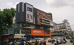
[[File:Malkajgiri cinepolis.jpeg|thumb|250px|[[Cinepolis]] in Malkajgiri]] | [[File:Malkajgiri cinepolis.jpeg|thumb|250px|[[Cinepolis]] in Malkajgiri]] | ||
* [[Safilguda lake]] | * [[Safilguda lake|Neredumettu Nadimi Cheruvu]] | ||
* [[Ramakrishnapuram Lake]] | * [[Ramakrishnapuram Lake|Neredumettu Munkidigan Cheruvu]] | ||
* [[Neredmet Banda Cheruvu]] | |||
* Sai baba temple<ref>{{Cite web|last=India|first=The Hans|date=2019-11-29|title=2K walk urges all to spread greenery at Malkajgiri|url=https://www.thehansindia.com/news/cities/hyderabad/2k-walk-urges-all-to-spread-greenery-at-malkajgiri-585740|access-date=2020-06-29|website=www.thehansindia.com|language=en}}</ref> | * Sai baba temple<ref>{{Cite web|last=India|first=The Hans|date=2019-11-29|title=2K walk urges all to spread greenery at Malkajgiri|url=https://www.thehansindia.com/news/cities/hyderabad/2k-walk-urges-all-to-spread-greenery-at-malkajgiri-585740|access-date=2020-06-29|website=www.thehansindia.com|language=en}}</ref> | ||
* [[Neredmet Moodu Gullu]] | * [[Neredmet Moodu Gullu]] | ||
Latest revision as of 07:13, 6 December 2025
 | This article needs more citations. (November 2024) |
Malkajgiri
Mallikarjuna Giri | |
|---|---|
Suburb, GHMC Circle, Sub-District | |
 Malkajgiri 'x' Roads | |
  Malkajgiri Malkajgiri (Telangana)  Malkajgiri Malkajgiri (India) | |
| Coordinates: 17°27′01.1″N 78°31′55.9″E / 17.450306°N 78.532194°E | |
| Country |  India India |
| State | Telangana |
| District | Medchal–Malkajgiri |
| City | Greater Hyderabad |
| Founded | 1578 AD |
| Incorporated (town) | 1965 |
| Incorporated (Corporation) | 1985 |
| Named for | Mallikarjuna Swamy |
| Government | |
| • Body | GHMC–Malkajgiri Circle Shri.GODHUMALA RAJU DEPUTY COMMISSIONER Special Grade Municipal Commissioner |
| Area | |
| • Total | 35.8 km2 (13.8 sq mi) |
| Elevation | 556 m (1,824 ft) |
| Population (2020)[1] | |
| • Total | 141,175 |
| • Density | 3,900/km2 (10,000/sq mi) |
| Languages | |
| • Official | Telugu |
| Time zone | UTC+5:30 (IST) |
| PIN Codes |
|
| Vehicle registration | TG-08 |
| Lok Sabha constituency | Malkajgiri |
| Vidhan Sabha constituency | Malkajgiri |
| Planning agency | Hyderabad Metropolitan Development Authority |
Malkajgiri also known as Mallikarjuna Giri (ancient name)[according to whom?] is a suburb of Hyderabad, Telangana, India. It is located in Medchal–Malkajgiri district and also Sub-District in Medchal District is the headquarters of Malkajgiri mandal in Malkajgiri revenue division. Erstwhile Malkajgiri Major Grampanchayat was upgraded to a municipality in 1965 and became a municipal corporation in 1985. It was merged into the Greater Hyderabad Municipal Corporation in 2007.[2] It was a part of Ranga Reddy district before the re-organisation of districts in 2016.[3]
Etymology[edit | edit source]
|
The ancient name of Malkajgiri was Mallikarjuna Giri (Before 1936's)[according to whom?], dedicated to Mallikarjuna Swamy Temple on Hills. Which eventually turned as the present. Earlier Malkajgiri has its own fort. Now its became ruins, we see walls and watch towers in Old Malkajgiri Area - Shaw Wallace Factory (Present).
The lakes like Safilguda Nadimi cheruvu, Safilguda Banda cheruvu, Ramakrishnapuram Munkidigan cheruvu are famous which falls under Neredmet (Esterwile Village). And also lots of small ponds which are vanished now. It has well connections with Moula-Ali history.
Demographics[edit | edit source]
As of the 2001 India census,[4] Malkajgiri had a population of 413,571. The population is 51% male and 49% female. Malkajgiri has an average literacy ratio of 87% with a total of 321,525 literates. In terms of literacy, Malkajgiri ranked at first in the Rangareddy district, higher than the national averages of 59.5%; male literacy is 72%, and female literacy is 65%. In Malkajgiri, 7% of the population is under 6 years of age.
History[edit | edit source]
Malkajgiri mandal before bifurcated used to be much larger, It consisted of two municipal units. They are Malkajgiri & Alwal Municipalities.
- Malkajgiri : Malkajgiri, Mirjalguda, Moulali, Neredmet, Yapral, Kowkoor.
- Alwal : Maccha Bollaram, Venkatapuram.
- After district bifurcation "or" formation Alwal Municipality became a New Mandal "Alwal mandal."
Villages in Malkajgiri Mandal[edit | edit source]
Malkajgiri is a Mandal in Ranga Reddy (Eastrwile) district of Telangana state in India. Below is the list of Towns and Villages in Malkajgiri Mandal. Total Number of Villages in this Mandal list are 7.
- Alwal (Municipality)
- Ammuguda
- Kowkur
- Lothkunta
- Macha Bolaram
- Malkajgiri (Municipality)
- Yapral
Later some villages merged in Alwal and formed Alwal Mandal by burificating Malkajgiri Mandal in 2017.
At Present now Malkajgiri Mandal has following neighbourhoods erstwhile Villages:
Malkajgiri has two revenue villages. They are Malkajgiri and Ammuguda Villages. Malkajgiri Major Village Consists of,
- Malkajgiri Main Village (Including Talla Basthi, Hanumanpet, Mirzalguda earlier Hamlet villages)
- Neredmet Main Village (Including earlier Hamlet villages Safilguda, Ramakrishnapuram)
- Moula Ali (Some parts of it later merged into Cherlapally Village i.e. Cherlapally Jail to Moula Ali Sub Station Areas).
The Ammuguda revenue village consists of,
Localities with in Malkajgiri Village[edit | edit source]
Malkajgiri Village has six sub regions in it. They are Old Malkajgiri, Malkajgiri X Roads, Old Mirzalguda, New Mirzalguda, Anutex, Hanumanpet.
Old Malakajgiri[edit | edit source]
- Bala Saraswathi Nagar
- Kummari Wada Basthi
- Narsimha Reddy Nagar
- Maruthi Nagar
- Old Malkajgiri Village
- Durga Nagar
- Sathi Reddy Nagar
- Chinthal Basthi
- Venkateshwara Nagar
- Patel Nagar
- Shawallace liquor company Area.(Ancient Fort Ruins Area)
Malkajgiri X Roads[edit | edit source]
- Sanjay Nagar
- Sanjeev Nagar
- Brundavan Colony
- Venkateshwara Nagar
- Geetha Nagar (Municipal Office & District Hospital Area)
- Shawallace liquor company Area
Old Mirzalguda[edit | edit source]
- Old Mirzalguda
- Mirzalguda X Road
- Yadav Nagar
- Ekalavya Nagar
- Goutham Nagar
- Mallikarjuna Nagar ( Ancient Mallanna Temple Area)
- Veena Pani Nagar
- Raja Nagar
- Madhusudhan Nagar
- Malkajgri Railway Station Area
- Bank Colony
- Sivapuri Colony
- New Shivapuri Colony
New Mizalguda[edit | edit source]
- Raja Srinivas Nagar Colony
- BJR Nagar
- Vasanthapuri Colony
- Sripuri Colony
- Ambedkar Nagar
- PVN Colony
- Raghavendra Nagar
- Vasantha Vihar Colony
- Jawahar Nagar
Anutex[edit | edit source]
- Vani Nagar
- Bhavani Nagar
- Sai Nagar ( Sai Baba Temple)
Hanumanpet[edit | edit source]
- Joythi Nagar
- Gopal Nagar
- I. N. Nagar
- J.L.N.S Nagar (Jayagiri Lakshmi Narasimha Swamy Temple Area)
- Hill Top Colony
- Sri Ramanjaneya Nagar
- New Venkateshwara Nagar
- Budha Vihar
Administration & Jurisdiction[edit | edit source]
Malkajgiri is administered by GHMC as Circle No. 28 which falls under Secunderabad Zone. It includes six wards which include:
- 136 Neredmet division
- 137 Vinayak nagar division
- 138 Moula Ali division
- 139 East anandbagh division
- 140 Malkajgiri division
- 141 Goutham Nagar division
Malkajgiri Mandal has also Administered by Mandal Revenue Office. It consists of Malkajgiri (M) Village & also Ammuguda Village.
Jurisdiction falls under Malkajgiri Metropolitan Court & 2 Police Station limits, Malkajgiri PS and Neredmet PS.

Transport[edit | edit source]
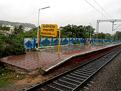
Malkajgiri is well-connected with other parts of the city by road as well as rail. The Malkajgiri Junction Railway Station is located at the backside of St. Martins High School will soon be converted into a major junction. Until now the station has 4 tracks and 3 Platforms in which 2nd&3rd Platforms are only Electrified. There is a Railway Reservation Complex too. thereby connecting it to most of the places by rail route.[5]
Nearest metro station is Mettuguda on Blue line of Hyderabad Metro.
Railway Stations[edit | edit source]

Malkajgiri has six Suburban railway stations with two more under construction.
- Malkajgiri Junction Railway Station
- Moula Ali Railway Station
- Safilguda Railway Station
- Dayanandnagar Railway Station
- Ramakistapuram Gate Railway Station
- Ammuguda Railway Station
Under Construction - MMTS Phase
Malkajgiri is less than 15 drive from Secunderabad Railway Station. It is also just 3 km away from Mettuguda junction, where the road leading to Uppal and the International Airport is being expanded into eight lanes. Malkajgiri is an emotion
Politics[edit | edit source]
Malkajgiri (Lok Sabha constituency) is India's largest constituency.[6] The Malkajgiri (Assembly constituency) is a new constituency formed after the delimitation of constituencies. The General elections held in 2009 were the first elections to be held in this constituency. Akula Rajender Mudiraj was elected as MLA in 2009. In the 2014 general assembly elections, C. Kanaka Reddy (TRS) won by 2768 votes against Ram Chander Rao.N (BJP).
Landmarks[edit | edit source]

- Neredumettu Nadimi Cheruvu
- Neredumettu Munkidigan Cheruvu
- Neredmet Banda Cheruvu
- Sai baba temple[7]
- Neredmet Moodu Gullu
References[edit | edit source]
- ↑ "Malkajgiri". Census of India.
- ↑ "Medchal-Malkajgiri district" (PDF). Official website of Medchal district. Archived from the original (PDF) on 22 March 2017. Retrieved 20 March 2017.
- ↑ "Medchal−Malkajgiri district" (PDF). New Districts Formation Portal. Government of Telangana. Archived from the original (PDF) on 30 November 2016. Retrieved 23 March 2017.
- ↑ "Census of India 2009: Data from the 2009 Census, including cities, villages and towns (Provisional)". Census Commission of India. Archived from the original on 16 June 2004. Retrieved 1 November 2008.
- ↑ "Proposal for the Fourth rail Terminal for Hyderabad and Electrification of whole line". The Hindu. 21 June 2006. Archived from the original on 6 May 2011. Retrieved 25 September 2009.
- ↑ IANS (2 April 2019). "TRS sitting pretty in India's largest constituency Malkajgiri (Constituency Profile)". Business Standard India. Retrieved 29 June 2020.
- ↑ India, The Hans (29 November 2019). "2K walk urges all to spread greenery at Malkajgiri". www.thehansindia.com. Retrieved 29 June 2020.