.svg)
Palashpai: Difference between revisions
imported>Chandan Guha (Removed stub tag) |
m (robot: Update article (please report if you notice any mistake or error in this edit)) |
||
| Line 55: | Line 55: | ||
| footnotes = | | footnotes = | ||
}} | }} | ||
'''Palashpai''' is a village in the [[Daspur II]] [[Community development blocks in India|CD block]] in the [[Ghatal subdivision]] of the [[Paschim Medinipur district]] in the state of [[West Bengal]], [[India]]. | '''Palashpai''' is a village in the [[Daspur II]] [[Community development blocks in India|CD block]] in the [[Ghatal subdivision]] of the [[Paschim Medinipur district]] in the state of [[West Bengal]], [[India]]. | ||
==Geography== | ==Geography== | ||
| Line 83: | Line 83: | ||
|mark-coord21={{coord|22|36|55|N|87|43|41|E}}| label-pos21=right|label21=Laoda| numbered21=H| mark-title21= [[Laoda]] (H) |shape-color21=#AA6666 | |mark-coord21={{coord|22|36|55|N|87|43|41|E}}| label-pos21=right|label21=Laoda| numbered21=H| mark-title21= [[Laoda]] (H) |shape-color21=#AA6666 | ||
|mark-coord22={{coord|22|34|30|N|87|36|54|E}}| label-pos22=right|label22=Narajole| numbered22=H| mark-title22= [[Narajole]] (H) |shape-color22=#AA6666 | |mark-coord22={{coord|22|34|30|N|87|36|54|E}}| label-pos22=right|label22=Narajole| numbered22=H| mark-title22= [[Narajole]] (H) |shape-color22=#AA6666 | ||
|mark-coord23={{coord|22|31|9|N|87|47|18|E}}| label-pos23=right|label23=Palashpai| numbered23=H| mark-title23= | |mark-coord23={{coord|22|31|9|N|87|47|18|E}}| label-pos23=right|label23=Palashpai| numbered23=H| mark-title23= Palashpai (H)|shape-color23=black| label-size23=13|label-color23=black <!-- make the subject of the article stand out with black colors --> | ||
|mark-coord24={{coord|22|33|37|N|87|44|38|E}}| label-pos24=left|label24=Radhakantapur| numbered24=H| mark-title24= [[Radhakantapur]] (H) |shape-color24=#AA6666 | |mark-coord24={{coord|22|33|37|N|87|44|38|E}}| label-pos24=left|label24=Radhakantapur| numbered24=H| mark-title24= [[Radhakantapur]] (H) |shape-color24=#AA6666 | ||
|mark-coord25={{coord|22|41|8|N|87|38|45|E}}| label-pos25=left|label25=Radhanagar| numbered25=H| mark-title25= [[Radhanagar, Paschim Medinipur]] (H) |shape-color25=#AA6666 | |mark-coord25={{coord|22|41|8|N|87|38|45|E}}| label-pos25=left|label25=Radhanagar| numbered25=H| mark-title25= [[Radhanagar, Paschim Medinipur]] (H) |shape-color25=#AA6666 | ||
| Line 113: | Line 113: | ||
File:Saptarath Sridharajiu Deul temple at Palashpai under Pashim Medinipur district in West Bengal 11.jpg|Terracotta decoration | File:Saptarath Sridharajiu Deul temple at Palashpai under Pashim Medinipur district in West Bengal 11.jpg|Terracotta decoration | ||
</gallery> | </gallery> | ||
==References== | ==References== | ||
Latest revision as of 08:51, 27 September 2021
Palashpai | |
|---|---|
Village | |
 Palashpai Location in West Bengal, India  Palashpai Palashpai (India) | |
| Coordinates: 22°31′10″N 87°47′18″E / 22.5194°N 87.7884°ECoordinates: 22°31′10″N 87°47′18″E / 22.5194°N 87.7884°E | |
| Country | |
| State | West Bengal |
| District | Paschim Medinipur |
| Population (2011) | |
| • Total | 4,800 |
| Languages | |
| • Official | Bengali, English |
| Time zone | UTC+5:30 (IST) |
| PIN | 721146 |
| Telephone/STD code | 03225 |
| Lok Sabha constituency | Ghatal |
| Vidhan Sabha constituency | Daspur |
| Website | paschimmedinipur |
Palashpai is a village in the Daspur II CD block in the Ghatal subdivision of the Paschim Medinipur district in the state of West Bengal, India.
Geography[edit]
| Cities and towns in Ghatal subdivision of Paschim Medinipur district M: municipal city/ town, R: rural/ urban centre, H: historical/ religious centre Owing to space constraints in the small map, the actual locations in a larger map may vary slightly |
Location[edit]
Palashpai is located at 22°31′10″N 87°47′18″E / 22.5194°N 87.7884°E.
Area overview[edit]
Ishwar Chandra Vidyasagar, scholar, social reformer and a key figure of the Bengal Renaissance, was born at Birsingha on 26 September 1820.[1][2]
Ghatal subdivision, shown in the map alongside, has alluvial soils. Around 85% of the total cultivated area is cropped more than once.[3] It has a density of population of 1,099 per km2, but being a small subdivision only a little over a fifth of the people in the district reside in this subdivision. 14.33% of the population lives in urban areas and 86.67% lives in the rural areas.[4]
Note: The map alongside presents some of the notable locations in the subdivision. All places marked in the map are linked in the larger full screen map.
Demographics[edit]
According to the 2011 Census of India, Palashpai had a total population of 4,800, of which 2,459 (51%) were males and 2,341 (49%) were females. There were 480 persons in the age range of 0–6 years. The total number of literate persons in Palashpai was 3,864 (89.44% of the population over 6 years).[5]
Education[edit]
Palashpai B.D. Balika Vidyalaya is a Bengali-medium girls only institution established in 1965. It has facilities for teaching from class V to class X. It has a library with 350 books and a playground.[6]
Bhagwanchak Patiram Sikshaniketan is a Bengali-medium coeducational institution established in 1950. It has facilities for teaching from class V to class XII. It has a library with 1,200 books and a playground.[7]
Palashpai picture gallery[edit]
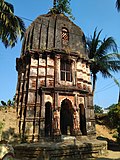
Saptarath Sridharjiu deul of the Maity family constructed in 1834
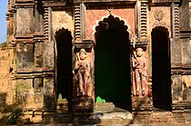
Temple entrance

Terracotta decoration


References[edit]
- ↑ Murshid, Ghulam. "Vidyasagar, Pundit Iswar Chandra". Banglapedia. Retrieved 24 July 2016.
- ↑ "Ishwar Chandra Vidyasagar". www.whereincity.com. Retrieved 24 July 2016.
- ↑ "District Human Development Report Paschim Medinipur, 2011". page 27-28. Department of Planning and Statistics, Government of West Bengal. Retrieved 10 September 2020.
- ↑ "District Statistical Handbook Paschim Medinipur, 2013". Table 2.2, 2.4 (a). Department of Planning and Statistics. Retrieved 10 September 2020.
- ↑ "CD block Wise Primary Census Abstract Data(PCA)". West Bengal – District-wise CD blocks. Registrar General and Census, India. Retrieved 24 August 2020.
- ↑ "Palashpai B.D. Balika Vid. U. Pry". Schools.org. Retrieved 24 August 2020.
- ↑ "Bhagwanchak Patiram Sikn. U. Pry". Schools.org. Retrieved 24 August 2020.