.svg)
Pondicherry: Difference between revisions
(→Climate: Made it easier to read the climate bar by changing the colours to the standard for Wikipedia) |
m (robot: Creating/updating articles) |
||
| (One intermediate revision by one other user not shown) | |||
| Line 1: | Line 1: | ||
{{About|the city|the [[union territory]]|Puducherry (union territory)|other uses|Puducherry (disambiguation)}} | {{About|the city|the [[union territory]]|Puducherry (union territory)|other uses|Puducherry (disambiguation)}} | ||
{{more citations needed|date=January 2017}} | {{more citations needed|date=January 2017}} | ||
{{Use dmy dates|date=February | {{Use dmy dates|date=February 2023}} | ||
{{Use Indian English|date=February 2019}} | {{Use Indian English|date=February 2019}} | ||
{{Infobox settlement | {{Infobox settlement | ||
| | | other_name = {{native name|fr|Pondichéry}} | ||
| | | name = Pondicherry | ||
| official_name | | official_name = Puducherry | ||
| settlement_type | | settlement_type = City | ||
| image_skyline | | blank_emblem_type = Seal of Puducherry Municipal Council | ||
| image_alt | | blank_emblem_size = 200px | ||
| image_caption | | blank_emblem_alt = | ||
| nickname | | image_blank_emblem = Pondicherry Municipal Council logo.png | ||
| image_map | | image_skyline = Pondy Montage.jpg | ||
| map_alt | | image_alt = | ||
| map_caption | | image_caption = Clockwise from top right: Gandhi statue, [[Promenade Beach]], [[Matrimandir]], [[Sri Aurobindo Ashram]], [[Immaculate Conception Cathedral, Pondicherry|Immaculate Conception Cathedral]], [[Aayi Mandapam (monument)|Aayi Mandapam]], [[Basilica of the Sacred Heart of Jesus, Pondicherry|Basilica of the Sacred Heart of Jesus]], [[Manakula Vinayagar Temple]] | ||
| pushpin_map | | nickname = {{hlist|"[[Paris]] of the East"|"Pondy"|"The City of Dawn"|"[[French Riviera]] of the East"}} | ||
| pushpin_label_position | | image_map = | ||
| pushpin_map_alt | | map_alt = | ||
| pushpin_map_caption | | map_caption = | ||
| coordinates | | pushpin_map = India Pondicherry#India | ||
| subdivision_type | | pushpin_label_position = right | ||
| subdivision_name | | pushpin_map_alt = | ||
| subdivision_type1 | | pushpin_map_caption = | ||
| subdivision_type2 | | coordinates = {{coord|11|55|N|79|49|E|display=inline,title}} | ||
| subdivision_name1 | | subdivision_type = Country | ||
| subdivision_name2 | | subdivision_name = India | ||
| established_title | | subdivision_type1 = [[States and union territories of India|Union territory]] | ||
| established_date | | subdivision_type2 = [[List of districts of India|District]] | ||
| founder | | subdivision_name1 = [[Puducherry (union territory)|Puducherry]] (PY) | ||
| named_for | | subdivision_name2 = [[Pondicherry district|Puducherry]] | ||
| government_type | | established_title = Established | ||
| governing_body | | established_date = 1674 | ||
| unit_pref | | founder = | ||
| area_footnotes | | named_for = | ||
| area_total_km2 | | government_type = Municipal Council | ||
| area_rank | | governing_body = [[Pondicherry Municipal Council]] (PDY) | ||
| elevation_footnotes | | unit_pref = Metric | ||
| elevation_m | | area_footnotes = <ref name="dchb"/> | ||
| population_total | | area_total_km2 = 19.54 | ||
| population_as_of | | area_rank = | ||
| population_footnotes | | elevation_footnotes = | ||
| population_density_km2 | | elevation_m = 3 | ||
| population_metro | | population_total = 244,377 | ||
| population_metro_footnotes | | population_as_of = 2011 | ||
| population_rank | | population_footnotes = | ||
| population_demonym | | population_density_km2 = auto | ||
| demographics_type1 | | population_metro = | ||
| demographics1_title1 | | population_metro_footnotes = | ||
| demographics1_title2 | | population_rank = | ||
| timezone1 | | population_demonym = Puducherrian, Pondicherrian, Pondian, Pondichérien, Pondichérienne | ||
| utc_offset1 | | demographics_type1 = Languages | ||
| postal_code_type | | demographics1_title1 = Official | ||
| postal_code | | demographics1_title2 = Additional | ||
| area_code | | timezone1 = [[Indian Standard Time|IST]] | ||
| area_code_type | | utc_offset1 = +5:30 | ||
| registration_plate | | postal_code_type = [[Postal Index Number|PIN CODE]] | ||
| website | | postal_code = 605001-605014 | ||
| footnotes | | area_code = (International) +91-413-, (National) 0413- | ||
| area_code_type = Telephone code | |||
| demographics1_info1 | | registration_plate = '''PY-01''' to '''PY-05''' | ||
| website = https://www.py.gov.in/ | |||
| footnotes = | |||
| demographics1_info1 = [[Tamil language|Tamil]], English | |||
| demographics1_info2 = French | |||
}} | }} | ||
'''Pondicherry''' ({{IPAc-en|ˌ|p|ɒ|n|d|ᵻ|ˈ|tʃ|ɛr|i}}), [[List of renamed places in India|now known as]] '''Puducherry''' ({{IPAc-en|ˌ|p|ʊ|d|ᵿ|ˈ|tʃ|ɛr|i}}), is the [[Capital city|capital]] and | '''Pondicherry''' ({{IPAc-en|ˌ|p|ɒ|n|d|ᵻ|ˈ|tʃ|ɛr|i}}), [[List of renamed places in India|now known as]] '''Puducherry''' ({{IPAc-en|ˌ|p|ʊ|d|ᵿ|ˈ|tʃ|ɛr|i}}; {{Lang-fr|Pondichéry}} {{IPA-fr|pɔ̃diʃeʁi|}}), is the [[Capital city|capital]] and most populous city of the [[Puducherry (union territory)|Union Territory of Puducherry]] in India. The city is in the [[Puducherry district]] on the southeast coast of India and is surrounded by the [[Bay of Bengal]] to the east and the state of [[Tamil Nadu]], with which it shares most of its culture, heritage, and language.<ref>{{Cite news|url=http://www.thehindu.com/todays-paper/tp-national/bill-to-rename-pondicherry-as-puducherry-passed/article3093958.ece|title=Bill to rename Pondicherry as Puducherry passed|date=22 August 2006|work=The Hindu|access-date=2 May 2016}}</ref> | ||
==History== | ==History== | ||
{{Main|History of Puducherry}} | {{Main|History of Puducherry}} | ||
[[File:Pondicherry waterfront 1900.jpg|thumb | {{More citations needed|section|date=February 2023}} | ||
[[File:Pondicherry waterfront 1900.jpg|thumb|left|Pondicherry waterfront circa 1900]] | |||
Puducherry, formerly known as Pondicherry, gained its significance as "The French Riviera of the East" after the advent of French colonialisation in India. Puducherry is the Tamil interpretation of "new town" and mainly derives from "Poduke", the name of the marketplace or "port town" for Roman trade in the 1st century, as mentioned in ''The Periplus of the Erythraean Sea''. The settlement was once an abode of learned scholars versed in the [[Vedas]], hence it was also known as Vedapuri.<ref>{{cite web |title=Pondicherry history |url=http://pondicherrysmartcity.in/history-pondicherry.php}}</ref> | |||
The history of Puducherry can broadly be classified into two periods: pre-colonial and colonial. The pre-colonial period started with the reign of the [[Pallava dynasty|Pallavas]], who ruled the empire from 325 to 900, after which came the [[Chola dynasty]], from 900 to 1279, and the [[Pandya dynasty]], from 1279 to 1370. During the 14th century, the city was under the rule of Naikship of Gingee of the [[Vijayanagara Empire]], from 1370 to 1614, when it was conquered by the [[Adil Shahi dynasty|Sultan of Bijapur]], who ruled it from 1614 to 1638. It was during this period that Portuguese and Danish merchants used it as a trading center. | |||
The | The colonial period began with the Portuguese, the first Europeans to conduct trade in textiles, in 1521, and subsequently, the Dutch and the Danes in the 17th century. | ||
The prospering trade of Puducherry attracted the French, and the predominant feature of the town was laid by the French pioneer Francois Martin in the form of a French settlement, in 1674. In 1693, Puducherry was captured by the Dutch and subsequently restored in 1699, with the [[Peace of Ryswick|Treaty of Ryswick]]. | |||
The French acquired Mahe in 1720, Yanam in 1731, and Karaikal in 1738. The British captured the city from the French but returned it following the Treaty of Paris, in 1763. This Anglo-French war continued until 1814, where France found itself in control of the settlements of Puducherry, Mahe, Yanam, Karaikal, and Chandernagar, even during the British period, until 1954. It was a reign of 138 years under the French, who on 31 October 1954 left Indian shores following a de facto transfer of power. | |||
On 21 August 1693, during the [[Nine Years' War]], Pondicherry was captured by the Dutch. | Nearby places such as [[Arikamedu]], [[Ariyankuppam]], Kakayanthoppe, [[Villianur]], and Bahour, which were colonised by the [[French East India Company]] over a period of time and later became the [[union territory]] of Pondicherry, have recorded histories that predate the colonial period. | ||
''Poduke'' or ''Poduca'' (marketplace) was a Roman trading destination from the third century BCE.<ref>{{Cite book|last=Francis|first=Peter|url=https://books.google.com/books?id=zzZBdGQN_TIC&pg=PA30|title=Asia's Maritime Bead Trade: 300 B.C. to the Present|date=2002|publisher=University of Hawaii Press|isbn=978-0-8248-2332-0}}</ref> ''Poduca'' has been identified as possibly being [[Arikamedu]] (now part of Ariyankuppam), located about {{Convert|2|mi|km}} from the modern city of Pondicherry. The area was part of the [[Pallava dynasty|Pallava]] Kingdom of [[Kanchipuram]] in the 4th century. The [[Chola dynasty|Cholas]] of [[Thanjavur]] held it from the 10th to the 13th centuries, until it was replaced by the [[Pandyan Dynasty|Pandya]] Kingdom, in the 13th century. The [[Vijayanagara Empire|Vijayanagar]] Empire took control of almost all of southern India in the 14th century and maintained control until 1638, when they were supplanted by the [[Adil Shahi dynasty|Sultan of Bijapur]]. | |||
In 1674, the French East India Company set up a trading centre at Pondicherry, and this outpost eventually became the chief [[French India|French settlement in India]]. The French governor [[François Martin (Pondicherry)|François Martin]] made remarkable improvements to the city and its commercial ties, facing at the same time strong opposition from the Dutch and the English. He entered into extended negotiations with the sultans of Golconda through the intercession of several roving French merchants and doctors who were in favour with the sultan. Trading in jewellery and precious stones, which had become highly fashionable in European courts, was one among many activities. Five trading posts were established along the south Indian coast between 1668 and 1674. The city was separated by a canal into the French Quarter and the Indian Quarter.<ref>{{Cite web|url=http://www.stuff.co.nz/travel/destinations/asia/78427269/peace-love-and-a-french-flavour-in-pondicherry-south-india|title=Peace, love and a French flavour in Pondicherry, South India|last=Worrall|first=Jill|date=11 April 2016|website=www.stuff.co.nz|access-date=2 May 2016}}</ref> | |||
On 21 August 1693, during the [[Nine Years' War]], Pondicherry was captured by the Dutch. The governor of [[Dutch Coromandel]], Laurens Pit the Younger, sailed with a fleet of seventeen ships and 1,600 men from [[Nagapattinam]] and bombarded Pondicherry for two weeks, after which Francois Martin surrendered it. At the [[Peace of Ryswick]], it was agreed by all parties to return conquered territories, and in 1699, Pondicherry was handed back to the French.<ref>{{Cite book|last=Israel|first=Jonathan|title=Dutch Primacy in World Trade 1585-1740|publisher=Oxford University Press|year=1989|isbn=0198227299|location=New York}}</ref> | |||
On 16 January 1761, the British captured Pondicherry from the French, but it was returned under the [[Treaty of Paris (1763)]], at the conclusion of the [[Seven Years' War]].<ref>Chand, Hukam. ''History Of Medieval India'', 202.</ref> The British took control of the area again in 1793, at the [[Siege of Pondicherry (1793)|Siege of Pondicherry]], amid the Wars of the [[French Revolution]], and returned it to France in 1814. | |||
[[File:Nehru à Pondichéry, janvier 1955.png|thumb|Prime Minister Nehru visiting Pondicherry a few months after the ''de facto'' transfer]] | [[File:Nehru à Pondichéry, janvier 1955.png|thumb|Prime Minister Nehru visiting Pondicherry a few months after the ''de facto'' transfer]] | ||
On 18 October 1954 in a general election involving 178 people in Pondicherry | On 18 March 1954, a number of resolutions were passed by the municipalities in Pondicherry, demanding an immediate merger with India. Some days later, similar resolutions were passed by the municipalities in Karaikal. The resolutions had the full support of the French Indian Councillors, popularly known as ministers, and the president of the representative assembly. These municipalities represented roughly ninety per cent of the population of the French possessions, and they called upon the government of France to take urgent and necessary measures to give effect to the wishes of the people.<ref>https://eparlib.nic.in/bitstream/123456789/55921/1/lsd_01_06_06-04-1954.pdf page 22</ref> The government of India had made it clear that the cultural and other rights of the people would be fully respected. They were not asking for the immediate transfer of ''de jure'' sovereignty of France. Their suggestion was that a ''de facto'' transfer of the administration should take place immediately, while French sovereignty should continue until the constitutional issue had been settled. Both India and France would have to make necessary changes in their respective constitutions. All this would take time, while the demand of the people was for an immediate merger without a referendum. The government of India was convinced that the suggestion which they made would help to promote a settlement, which they greatly desired.<ref>https://eparlib.nic.in/bitstream/123456789/55921/1/lsd_01_06_06-04-1954.pdf page 23</ref> | ||
On 18 October 1954, in a general election involving 178 people in municipal Pondicherry and the Commune of Panchayat, 170 people were in favour of the merger, and eight people voted against. The ''[[de facto]]'' transfer of the French Indian territories from French governance to the Indian union took place on 1 November 1954 and was established as the union territory of [[Puducherry (union territory)|Pondicherry]]. The treaty effecting the ''[[de jure]]'' transfer was signed in 1956. However, due to opposition in France, the ratification of this treaty by the French National Assembly only took place on 16 August 1962. | |||
==Topography== | ==Topography== | ||
The [[topography]] of Pondicherry is the same as that of coastal [[Tamil Nadu]]. Pondicherry's average elevation is at [[sea level]] | The [[topography]] of Pondicherry is the same as that of coastal [[Tamil Nadu]]. Pondicherry's average elevation is at [[sea level]] and includes a number of sea inlets, referred to locally as "[[Kerala backwaters|backwaters]]". Pondicherry experiences extreme [[coastal erosion]] as a result of a [[Breakwater (structure)|breakwater]] constructed in 1989,<ref>{{Cite web|url=https://memestreamblog.wordpress.com/2008/10/16/the-story-of-pondicherrys-eroding-coastline-in-a-single-image/|title=The Story of Pondicherry's Eroding Coastline in a Single Image|date=16 October 2008}}</ref> just to the south of the city. Where there was once a broad, sandy beach, now the city is protected against the sea by a 2-km-long [[seawall]] that sits at a height of 8.5 m above sea level. Whilst there was an early seawall made by the French government in 1735, this was not "hard structure coastal defence" so much as an adjunct to the old shipping pier and a transition from the beach to the city.<ref>{{cite web |url=http://www.pondicherryonline.in/Profile/Geography/ |title=Geography of Pondicherry, Geographical Location of Pondicherry, Pondicherry Natural Features |access-date=22 June 2009 |url-status=dead |archive-url=https://web.archive.org/web/20090916004530/http://pondicherryonline.in/Profile/Geography/ |archive-date=16 September 2009 }}</ref> | ||
Today, the seawall consists of rows of granite boulders | Today, the seawall consists of rows of granite boulders reinforced every year in an attempt to stop erosion. As a consequence of the seawall, there is severe seabed erosion and turbulence at the coastal margin, resulting in an extreme [[loss of biodiversity]] within the critical [[intertidal zone]]. Whenever gaps appear as the stones fall into the continually eroding seabed, the government adds more boulders. Pondicherry's seawall has also caused beach erosion to migrate further up the coast, to the fishing villages in Puducherry and Tamil Nadu to the north of the city.{{Citation needed|date=June 2019}} | ||
==Economy== | ==Economy== | ||
In 2012, the [[Ministry of Power (India)|Ministry of Power]] inaugurated the | In 2012, the [[Ministry of Power (India)|Ministry of Power]] inaugurated the "Smart Grid" project in Puducherry.<ref name="smartgrid">{{cite news|title=Smart grid project inaugurated|url=http://www.thehindu.com/todays-paper/tp-national/tp-tamilnadu/smart-grid-project-inaugurated/article4015596.ece|date=20 October 2012|agency=[[The Hindu]]|location=Puducherry|access-date=23 October 2012}}</ref> Farming around Pondicherry includes crops such as rice, pulses, sugarcane, coconuts, and cotton. | ||
In 2016, the Pondicherry State Government Employees Central Federation presented a status paper on the fiscal and social crisis in Puducherry to Union Home Minister [[Rajnath Singh]]. The report stated that a "combination of a staggering debt, stagnant tax revenues and rampant misappropriation of funds has throttled the economy of the Union Territory" and called for measures on a war footing to "deliver good governance and end corruption. | In 2016, the Pondicherry State Government Employees Central Federation presented a status paper on the fiscal and social crisis in Puducherry to Union Home Minister [[Rajnath Singh]]. The report stated that a "combination of a staggering debt, stagnant tax revenues and rampant misappropriation of funds has throttled the economy of the Union Territory" and called for measures on a war footing to "deliver good governance and end corruption".<ref>{{cite news|url=http://www.thehindu.com/news/cities/puducherry/Report-paints-grim-picture-of-Puducherry%E2%80%99s-economy/article14394348.ece|title=Report paints grim picture of Puducherry's economy|newspaper=The Hindu|date=18 October 2016|access-date=28 October 2017}}</ref> | ||
==Climate== | ==Climate== | ||
The [[climate]] of Pondicherry is classified by the [[Köppen climate classification]] as [[tropical savanna climate|tropical wet and dry]] | The [[climate]] of Pondicherry is classified by the [[Köppen climate classification]] as [[tropical savanna climate|tropical wet and dry]],<ref name="Climate-Data.org">{{cite web|title=Climate: Pondicherry – Climate graph, Temperature graph, Climate table|url=http://en.climate-data.org/location/2790/|publisher=Climate-Data.org|access-date=6 October 2013}}</ref> similar to that of coastal Tamil Nadu. Summer lasts from April to early June, when maximum temperatures may reach {{convert|41|°C|0}}. The average maximum temperature is {{convert|36|°C|0}}. Minimum temperatures are in the order of {{convert|28|-|32|°C|°F|0}}. This is followed by a period of high humidity and occasional thundershowers from June until September. | ||
The [[northeast monsoon#Post-monsoon|northeast monsoon]] sets in during the middle of October, and Pondicherry gets the bulk of its annual rainfall during the period from October to December. The annual average rainfall is {{convert|1355|mm|in|0|disp=or}}.<ref>{{cite web |url=http://education.vsnl.com/imdchennai/rdwr.htm |title= | The [[northeast monsoon#Post-monsoon|northeast monsoon]] sets in during the middle of October, and Pondicherry gets the bulk of its annual rainfall during the period from October to December. The annual average rainfall is {{convert|1355|mm|in|0|disp=or}}.<ref>{{cite web |url=http://education.vsnl.com/imdchennai/rdwr.htm |title=Government of India |access-date=10 July 2009 |url-status=dead |archive-url=https://web.archive.org/web/20090726170455/http://education.vsnl.com/imdchennai/rdwr.htm |archive-date=26 July 2009 }}</ref> Winters are very warm, with highs of {{convert|30|°C|0}} and lows often dipping to around {{convert|18|-|20|°C|°F|0}}. | ||
{{Weather box|width=70% | {{Weather box|width=70% | ||
| Line 178: | Line 195: | ||
|Dec rain days = 6.8 | |Dec rain days = 6.8 | ||
|year rain days = 55.0 | |year rain days = 55.0 | ||
|source 1 = India Meteorological Department (record high and low up to 2010)<ref name=IMD>{{cite web|url=http://www.imd.gov.in/section/climate/extreme/pondicherry2.htm|title=Pondicherry Climatological Table Period: 1971–2000|publisher=[[India Meteorological Department]]|access-date=11 April 2015}}</ref><ref name=IMD2>{{cite web |url=http://www.imdpune.gov.in/Temp_Extremes/histext2010.pdf |title=Ever recorded Maximum and minimum temperatures up to 2010 |publisher=India Meteorological Department |access-date=11 April 2015 |url-status=dead |archive-url=https:// | |source 1 = India Meteorological Department (record high and low up to 2010)<ref name=IMD>{{cite web|url=http://www.imd.gov.in/section/climate/extreme/pondicherry2.htm|title=Pondicherry Climatological Table Period: 1971–2000|publisher=[[India Meteorological Department]]|access-date=11 April 2015}}</ref><ref name=IMD2>{{cite web |url=http://www.imdpune.gov.in/Temp_Extremes/histext2010.pdf |title=Ever recorded Maximum and minimum temperatures up to 2010 |publisher=India Meteorological Department |access-date=11 April 2015 |url-status=dead |archive-url=https://web.archive.org/web/20140316064314/http://www.imdpune.gov.in/Temp_Extremes/histext2010.pdf |archive-date=16 March 2014 }}</ref> | ||
}} | }} | ||
==Demographics== | ==Demographics== | ||
[[File:Long exposure shot of Beach road near Pondicherry harbour.jpg|thumb|Long | [[File:Long exposure shot of Beach road near Pondicherry harbour.jpg|thumb|Long-exposure shot of Pondicherry beach road]] | ||
[[File: | [[File:Harry 1.jpg|thumb|The Rajiv Gandhi Women and Children Hospital]] | ||
According to the [[2011 census of India]], Pondicherry had a population of 244,377, with 124,947 females and 119,430 males. | According to the [[2011 census of India]], Pondicherry had a population of 244,377, with 124,947 females and 119,430 males. It had an average literacy rate of 80.6%, with male literacy at 84.6% and female literacy at 76.7%. Ten per cent of the population was under six years of age.<ref name="dchb">{{cite web |title=District Census Handbook: Puducherry |url=http://censusindia.gov.in/2011census/dchb/3402_PART_B_DCHB_PUDUCHERRY.pdf |website=Census of India |publisher=Office of the Registrar General & Census Commissioner, India |access-date=11 February 2019 |pages=86–87}}</ref> | ||
The majority speak [[Tamil language|Tamil]] | The majority of people in Pondicherry speak [[Tamil language|Tamil]]. There is a community of [[French people in India|French people]] and a number of French institutions, such as a French consulate, the [[French Institute of Pondicherry]], and L'[[Alliance française]].<ref>{{cite web | title = Pondicherry: Forever France? by Anand Jha | url = http://www.boloji.com/index.cfm?md=Content&sd=Articles&ArticleID=823 | date = 21 July 2012 | archive-url = https://archive.today/2012.07.21-144955/http://www.boloji.com/index.cfm?md=Content&sd=Articles&ArticleID=823 | archive-date = 21 July 2012 | access-date = 3 October 2013 | url-status = live }}</ref> | ||
== Civic administration == | ==Civic administration== | ||
The city of Puducherry comprises two municipalities, [[Pondicherry Municipal Council|Puducherry]] and [[Uzhavarkarai]]. Both the municipalities and the ''commune panchayats'' in the Union Territory of Puducherry function under the administrative control of the local administration department.<ref>{{Cite web|url=https://www.py.gov.in/knowpuducherry/dept_localadministration.html|title=Local Administration Departments Know Puducherry: Government of Puducherry|website=www.py.gov.in|access-date=9 April 2020}}</ref> The Puducherry municipality, under the Puducherry district, comprises the former communes of Puducherry and Mudaliarpet, with its headquarters in Puducherry. It has a total of 42 wards spread over an area of {{cvt|19.46|km2}}.<ref>{{Cite web|url=http://www.pdymun.in/puducherry-municipality-details.php|title=Municipality Details – Pondicherry Municipality – The Union Territory of Puducherry|website=www.pdymun.in|access-date=9 April 2020}}</ref> Wards 1–10 are north of the city; wards 11–19 are in ''Boulevard Town'', and the remaining wards are southwest of the city centre.<ref>[http://jnnurmmis.nic.in/toolkit/CDP_Puducherry.pdf Town and Country Planning Department, Pondicherry, India: ''City Development Plan – Pondicherry, Final Report'', March 2007, S. 159] {{webarchive |url=https://web.archive.org/web/20090619092759/http://jnnurm.nic.in/nurmudweb/toolkit/CDP_Puducherry.pdf |date=19 June 2009}}</ref> | |||
The city of Puducherry comprises two | |||
==Urban agglomeration== | ==Urban agglomeration== | ||
| Line 202: | Line 218: | ||
|- | |- | ||
| Pondicherry Municipality | | Pondicherry Municipality | ||
| 19 | | {{cvt|19|km2}} | ||
| 241,773 | | 241,773 | ||
|- | |- | ||
| Oulgaret Municipality | | Oulgaret Municipality | ||
| 36 | | {{cvt|36|km2}} | ||
| 300,028 | | 300,028 | ||
|- | |- | ||
| Line 218: | Line 234: | ||
|- | |- | ||
! Total | ! Total | ||
! 293 | ! {{cvt|293|km2}} | ||
! 629,509 | ! 629,509 | ||
|} | |} | ||
===Data according to 2011 census=== | ===Data according to the 2011 census=== | ||
There are two proposals by the Puducherry government, firstly to merge Pondicherry and [[Oulgaret]] municipalities and upgrade the Pondicherry municipality into a '"[[municipal corporation]]", and secondly to upgrade [[Villianur]] and [[Ariyankuppam]] commune panchayats into municipalities, which would increase the Pondicherry region's urban area around {{cvt|155|km2}} of the total {{cvt|292|km2}}. | |||
There are two proposals by the Puducherry government, firstly to merge Pondicherry and [[Oulgaret]] municipalities | |||
==Transport== | ==Transport== | ||
[[ | [[File:Puducherry train station.JPG|thumb|Puducherry Railway Station]] | ||
[[File:PNY airside.jpg|thumb|[[Pondicherry Airport]]]] | [[File:PNY airside.jpg|thumb|[[Pondicherry Airport]]]] | ||
===Road=== | ===Road=== | ||
Pondicherry is connected to [[Chennai]] via the [[East Coast Road]] through [[Mahabalipuram]].<ref name="ECRfastlane">{{cite news|title=After a decade on fast lane, ECR is set to expand |url=http://www.thehindu.com/todays-paper/tp-national/tp-tamilnadu/article2922388.ece |first=Deepa|last=Ramakrishnan|date=23 February 2012 |work=[[The Hindu]]|location=Chennai|access-date=16 September 2012}}</ref> | Pondicherry is connected to [[Chennai]] via the [[East Coast Road]] through [[Mahabalipuram]].<ref name="ECRfastlane">{{cite news|title=After a decade on fast lane, ECR is set to expand |url=http://www.thehindu.com/todays-paper/tp-national/tp-tamilnadu/article2922388.ece |first=Deepa|last=Ramakrishnan|date=23 February 2012 |work=[[The Hindu]]|location=Chennai|access-date=16 September 2012}}</ref> There are daily bus services from several main stops from Chennai. The [[Pondicherry Road Transport Corporation]] runs buses within the city and outside.<ref name="urbanroutes">{{cite news|title=20 buses launched in urban routes | url=http://www.thehindu.com/todays-paper/tp-national/tp-tamilnadu/article466675.ece |date=8 June 2010|work=[[The Hindu]]|location=Puducherry|access-date=19 September 2012}}</ref> The [[Tamil Nadu State Transport Corporation]] operates air-conditioned bus services from Chennai to Pondicherry.<ref name="boonkancheetnstc">{{cite news |title=A boon to Kancheepuram unit of TNSTC |url=http://www.hindu.com/2010/02/19/stories/2010021950820200.htm |archive-url=https://web.archive.org/web/20100224011329/http://www.hindu.com/2010/02/19/stories/2010021950820200.htm |url-status=dead |archive-date=24 February 2010 |first=Venkatasubramanian |last=V|date=19 February 2010|work=[[The Hindu]] |location=Kancheepuram|access-date=15 September 2012}}</ref> | ||
===Rail=== | ===Rail=== | ||
[[Puducherry railway station| | [[Puducherry railway station|Pondicherry]] is connected by train to all major Indian cities, such as Chennai, [[Delhi]], [[Kolkata]] ([[Howrah]]), [[Mumbai]], [[Kanyakumari]], [[Hyderabad]], [[Nagpur]], [[Bhubaneswar]], [[Bengaluru]], [[Visakhapatnam]], and [[Mangalore]].<ref name="delhitrain">{{cite news|title=Delhi-Puducherry train link from July 3 |url=http://www.thehindu.com/todays-paper/tp-national/tp-tamilnadu/article2133605.ece|date=25 June 2011|work=[[The Hindu]]|access-date=16 September 2012}}</ref><ref name="mangaloretrain">{{cite news|title=Changes in train timings |url=http://www.thehindu.com/todays-paper/tp-national/tp-tamilnadu/article3891397.ece|date=13 September 2012|work=[[The Hindu]]|location=Puducherry|access-date=16 September 2012}}</ref> Moreover, [[Viluppuram Junction railway station|Villupuram Junction]], which is at a distance of around {{cvt|24|mile}}, is connected to several other Indian cities.<ref>{{Cite web|url=https://www.rome2rio.com/map/Puducherry/Villupuram|title=Puducherry to Villupuram – 3 ways to travel via bus, and line 16116 train|website=Rome2rio|language=en|access-date=28 January 2020}}</ref> | ||
===Air=== | ===Air=== | ||
[[Pondicherry Airport]] is located at [[Lawspet]], an Assembly Constituency in the | [[Pondicherry Airport]] is located at [[Lawspet]], an Assembly Constituency in the Union Territory of Puducherry.<ref name="The Economic Times 2017">{{cite web | title=Puducherry back on aviation map; services to Hyderabad launched | website=The Economic Times | date=16 August 2017 | url=https://economictimes.indiatimes.com/industry/transportation/airlines-/-aviation/puducherry-back-on-aviation-map-services-to-hyderabad-launched/articleshow/60089905.cms | access-date=12 February 2019}}</ref> It has direct flights to [[Rajiv Gandhi International Airport|Hyderabad]]<ref name="The Economic Times 2017"/> and [[Kempegowda International Airport|Bengaluru]]. | ||
==Tourism== | ==Tourism== | ||
{{Main|Tourism in Puducherry}} | {{Main|Tourism in Puducherry}} | ||
[[File:PondicherryFrenchWarMemorial.jpg|thumb|upright|French War Memorial]] | [[File:PondicherryFrenchWarMemorial.jpg|thumb|upright|French War Memorial]] | ||
[[File:The French Consulate building.JPG|thumb|The French consulate in Pondicherry | [[File:The French Consulate building.JPG|thumb|The French consulate in Pondicherry]] | ||
[[File:"White Monument at Evening".jpg|thumb|222x222px|[[Aayi Mandapam (monument)|Aayi Mandapam (Park Monument]] | [[File:"White Monument at Evening".jpg|thumb|222x222px|[[Aayi Mandapam (monument)|Aayi Mandapam (Park Monument)]] at Bharathi Park]] | ||
Pondicherry is a tourist destination. The city has many colonial buildings, churches, temples and statues which, combined with the town planning and French style avenues in the old | |||
Pondicherry is a tourist destination. The city has many colonial buildings, churches, temples, and statues which, combined with the town planning and French-style avenues in the old districts, still preserve much of the colonial ambiance. | |||
While the sea is a draw for tourists, Pondicherry no longer has the sandy beaches that once graced its coastline.{{citation needed|date=April 2019}} The breakwater to the harbour and other hard structures constructed on the shore caused extreme | While the sea is a draw for tourists, Pondicherry no longer has the sandy beaches that once graced its coastline.{{citation needed|date=April 2019}} The breakwater to the harbour and other hard structures constructed on the shore caused extreme coastal erosion, and the sand from Pondicherry's [[Promenade Beach]] has disappeared entirely. As a result of the city's seawall and [[groyne]] construction, the beaches further up the coast to the north have also been lost. An enormous deposition of sand has accrued to the south of the harbour breakwater, but this is not a large beach and is not easily accessible from the city.{{citation needed|date=March 2023}} | ||
The government has taken steps to construct a reef and re-dose the sand. The sea is accessible by a small patch of land at Promenade Beach (Goubert Avenue).<ref>{{Cite web|url=https://www.deccanchronicle.com/nation/current-affairs/300818/artificial-reef-helps-restore-lost-pondy-beach.html|title=Artificial reef helps restore lost Pondy beach|last=M|first=Kavya|date=30 August 2018|website=Deccan Chronicle|access-date=28 January 2020}}</ref> Moreover, the beach is one of the cleanest in India and has been selected for [[Blue Flag beach|Blue Flag]] certification.<ref>{{Cite web|url=https://timesofindia.indiatimes.com/city/puducherry/beach-in-puducherry-selected-for-blue-flag-certification/articleshow/69668759.cms|title=Beach in Puducherry selected for blue flag certification|date=6 June 2019|first=Bosco|last=Dominique |website=The Times of India|language=en|access-date=28 January 2020}}</ref> | |||
[[File:Aurobindo Ashram Pondichery - Outside view.jpg|thumb|right|Visitors at the Sri Aurobindo Ashram]] | [[File:Aurobindo Ashram Pondichery - Outside view.jpg|thumb|right|Visitors at the Sri Aurobindo Ashram]] | ||
The Sri Aurobindo Ashram, located on Rue de la Marine, is one of the most important [[ashram]]s in India, founded by the [[Indian independence movement|freedom fighter]] and spiritual philosopher [[Sri Aurobindo]].<ref>{{Cite web|url=https://www.sriaurobindoashram.org/sriaurobindo/|title=Sri Aurobindo|access-date=19 July 2019}}</ref> [[Auroville]] (City of Dawn) is an "experimental" township located {{cvt|8|km}} northwest of Pondicherry. | |||
There are a number of old and large churches in Pondicherry, most of which were built in the 18th and 19th centuries. A number of heritage buildings and monuments are present around Promenade Beach, such as the Children's Park and Dupleix Statue, Gandhi statue, Nehru statue, Le Café, French War Memorial, 19th Century Light House, Bharathi Park, Governors Palace, [[Romain Rolland Library]], Legislative Assembly, [[Pondicherry Museum]], and the [[French Institute of Pondicherry]] at Saint Louis Street. | |||
Puducherry Botanical Gardens is located south of the New Bus Stand. Chunnambar Backwater resort is {{cvt|8|km}}from Pondicherry, along Cuddalore Main Road. This tropical resort is flanked by a creek on one side. | |||
Arulmigu Manakula Vinayagar Devasthanam on Manakula Vinayagar Street is a Hindu temple to Ganesha. Sri Manakula Vinayagar Temple was in existence before the French came and settled in Pondicherry in 1666.<ref>{{Cite web|url=http://www.manakulavinayagartemple.com/|title=Arulmigu Manakula Vinayagar Temple|access-date=19 July 2019}}</ref> | |||
[[Sri Sengazhuneer Amman Temple|Sengazhuneer Amman]] at [[Veerampattinam]] village is one of the oldest temples in Pondicherry, situated about {{cvt|7|km}} away from the city centre. The car festival conducted in mid-August is famous in Puducherry and other neighbouring states. The festival takes place on the fifth Friday since the commencement of the Tamil month of 'Aadi' every year.{{citation needed|date=March 2023}} | |||
Thirukaameeswarar Temple is located in a rural town called [[Villianur]],<ref>{{Cite web|url=http://indiatourismonline.in/2018/06/26/about-pondicherry/|title=About Pondicherry|website=India tourism|access-date=19 July 2019}}</ref> located about {{cvt|10|km}}, towards Villupuram. | |||
{{Panorama | {{Panorama | ||
|image = File:Pondicherry Panorama 1.jpg| | |image = File:Pondicherry Panorama 1.jpg| | ||
|height = 300 | |height = 300 | ||
|caption = | |caption = {{center|Panoramic view of Pondicherry}} | ||
}} | }} | ||
==Notable people== | ==Notable people== | ||
===Leaders=== | |||
* [[V. Subbiah]], trade union leader and freedom fighter | |||
=== | ===Literature and arts=== | ||
* [[ | * [[Bharathidasan]], [[Tamil people|Tamil]] poet | ||
* [[Anandaraj]], actor | |||
* [[Kalki Koechlin]], actress | |||
* [[Anandaraj]], | |||
* [[Kalki Koechlin]], | |||
===Science and technology=== | ===Science and technology=== | ||
* [[S. Somasegar]], former senior vice-president, [[Microsoft]] | * [[S. Somasegar]], former senior vice-president, [[Microsoft]] | ||
* [[Ganapathi Thanikaimoni]], | * [[Ganapathi Thanikaimoni]], scientist and director of the Palynology laboratory of the French Institute of Pondicherry | ||
* [[Yvonne Artaud]], French educationalist and psychologist | * [[Yvonne Artaud]], French educationalist and psychologist | ||
* [[Navi Radjou]], | * [[Navi Radjou]], innovation and leadership strategist based in Silicon Valley<ref>{{Cite web |url=http://thinkbusiness.nus.edu/articles/item/126 |title=Frugal innovation: From East to West and back again |access-date=19 January 2015 |archive-url=https://web.archive.org/web/20150119065707/http://thinkbusiness.nus.edu/articles/item/126 |archive-date=19 January 2015 |url-status=dead}}</ref> | ||
===Armed forces=== | ===Armed forces=== | ||
* | * [[Jacques Lauriston]] (1768–1828), senior-ranking military commander in the [[French Army]], born in Pondicherry | ||
== | ==Popular culture== | ||
* [[Prince Pondicherry]], a character from [[Roald Dahl]]'s ''[[Charlie and the Chocolate Factory]]'', | * [[Prince Pondicherry]], a character from [[Roald Dahl]]'s ''[[Charlie and the Chocolate Factory]]'', named after the city | ||
*Pondicherry is the setting for the first third of [[Yann Martel]]'s [[Booker Prize]]-winning novel ''[[Life of Pi]]'' | * Pondicherry is the setting for the first third of [[Yann Martel]]'s 2001 [[Booker Prize]]-winning novel, ''[[Life of Pi]]''. A portion of the subsequent [[Life of Pi (film)|film adaptation]] was filmed there.<ref>{{Cite news|url=https://www.theguardian.com/travel/gallery/2012/dec/20/life-of-pi-on-location-pondicherry|title=Life of Pi|website=The Guardian|date=20 December 2012 |access-date=19 July 2019}}</ref> | ||
*[[Lee Langley]]'s novel ''A House in Pondicherry'' | * [[Lee Langley]]'s 1995 novel, ''A House in Pondicherry'' is set here.<ref>{{Cite web|url=https://www.indiatoday.in/magazine/society-the-arts/books/story/19951031-book-review-lee-langley-house-in-pondicherry-807882-1995-10-31|title=Of Love Lost|website=India Today|access-date=19 July 2019}}</ref> | ||
==Educational institutions== | ==Educational institutions== | ||
* [[Jawaharlal Institute of Postgraduate Medical Education and Research ]] | * [[Jawaharlal Institute of Postgraduate Medical Education and Research]] | ||
* [[Lycée français de Pondichéry]] | |||
* [[Pondicherry University]] | * [[Pondicherry University]] | ||
* [[Puducherry Technological University]] | * [[Puducherry Technological University]] | ||
| Line 303: | Line 317: | ||
==Gallery== | ==Gallery== | ||
<gallery> | <gallery> | ||
File:Nerhu Statue, Pondicherry.jpg|thumb|Nehru Statue | File:Pondicherry, Puducherry, India.jpg|Rue De La Marine | ||
File:Pondicherry Manakula Vinayagar Temple.JPG|Gate leading into Manakula Vinayagar Temple in White Town | File:Pondicherry, India.jpg|Rue Saint Louis | ||
File:DSC 1218-EFFECTS.jpg|Tanjore | File:Nerhu Statue, Pondicherry.jpg|thumb|Nehru Statue | ||
File:Elephant Lakshmi.jpg|Devotees with Elephant Lakshmi in Manakula Vinayagar Temple | File:Pondicherry Manakula Vinayagar Temple.JPG|Gate leading into Manakula Vinayagar Temple in White Town | ||
File:Beach | File:DSC 1218-EFFECTS.jpg|Tanjore painting of Manakula Vinayagar | ||
File:Sunrise at the Pondicherry shore of happiness,.jpg|Early morning | File:Elephant Lakshmi.jpg|Devotees with Elephant Lakshmi in Manakula Vinayagar Temple | ||
File:Pondicherry Beach, Hut, India.jpg|Beach by the Bay of Bengal | |||
File:Pondicherry, Promenade Beach, Bay of Bengal, India.jpg|Bay of Bengal | |||
File:Sunrise at the Pondicherry shore of happiness,.jpg|Early morning by the Bay of Bengal | |||
</gallery> | </gallery> | ||
== See also == | ==See also== | ||
* [[Karaikal]], India | * [[Karaikal]], India | ||
* [[Mahé, India]] | * [[Mahé, India]] | ||
| Line 333: | Line 350: | ||
[[Category:Municipalities of Puducherry]] | [[Category:Municipalities of Puducherry]] | ||
[[Category:Indian union territory capitals]] | [[Category:Indian union territory capitals]] | ||
[[Category:1674 establishments in the French colonial empire]] | [[Category:1674 establishments in the French colonial empire]] | ||
[[Category:Populated places established in 1674]] | [[Category:Populated places established in 1674]] | ||
Latest revision as of 17:13, 6 March 2023
This article needs additional citations for verification. (January 2017) |
Pondicherry
Pondichéry (French) | |
|---|---|
City | |
| Puducherry | |
 Clockwise from top right: Gandhi statue, Promenade Beach, Matrimandir, Sri Aurobindo Ashram, Immaculate Conception Cathedral, Aayi Mandapam, Basilica of the Sacred Heart of Jesus, Manakula Vinayagar Temple | |
Official logo of Pondicherry Seal of Puducherry Municipal Council | |
Nicknames:
| |
| Lua error in Module:Location_map at line 526: Unable to find the specified location map definition: "Module:Location map/data/India Pondicherry" does not exist. | |
| Coordinates: 11°55′N 79°49′E / 11.917°N 79.817°ECoordinates: 11°55′N 79°49′E / 11.917°N 79.817°E | |
| Country | India |
| Union territory | Puducherry (PY) |
| District | Puducherry |
| Established | 1674 |
| Government | |
| • Type | Municipal Council |
| • Body | Pondicherry Municipal Council (PDY) |
| Area | |
| • Total | 19.54 km2 (7.54 sq mi) |
| Elevation | 3 m (10 ft) |
| Population (2011) | |
| • Total | 244,377 |
| • Density | 13,000/km2 (32,000/sq mi) |
| Demonym(s) | Puducherrian, Pondicherrian, Pondian, Pondichérien, Pondichérienne |
| Languages | |
| • Official | Tamil, English |
| • Additional | French |
| Time zone | UTC+5:30 (IST) |
| PIN CODE | 605001-605014 |
| Telephone code | (International) +91-413-, (National) 0413- |
| Vehicle registration | PY-01 to PY-05 |
| Website | https://www.py.gov.in/ |
Pondicherry (/ˌpɒndɪˈtʃɛri/), now known as Puducherry (/ˌpʊdʊˈtʃɛri/; French: Pondichéry [pɔ̃diʃeʁi]), is the capital and most populous city of the Union Territory of Puducherry in India. The city is in the Puducherry district on the southeast coast of India and is surrounded by the Bay of Bengal to the east and the state of Tamil Nadu, with which it shares most of its culture, heritage, and language.[2]
History[edit]
This section needs additional citations for verification. (February 2023) |

Puducherry, formerly known as Pondicherry, gained its significance as "The French Riviera of the East" after the advent of French colonialisation in India. Puducherry is the Tamil interpretation of "new town" and mainly derives from "Poduke", the name of the marketplace or "port town" for Roman trade in the 1st century, as mentioned in The Periplus of the Erythraean Sea. The settlement was once an abode of learned scholars versed in the Vedas, hence it was also known as Vedapuri.[3]
The history of Puducherry can broadly be classified into two periods: pre-colonial and colonial. The pre-colonial period started with the reign of the Pallavas, who ruled the empire from 325 to 900, after which came the Chola dynasty, from 900 to 1279, and the Pandya dynasty, from 1279 to 1370. During the 14th century, the city was under the rule of Naikship of Gingee of the Vijayanagara Empire, from 1370 to 1614, when it was conquered by the Sultan of Bijapur, who ruled it from 1614 to 1638. It was during this period that Portuguese and Danish merchants used it as a trading center.
The colonial period began with the Portuguese, the first Europeans to conduct trade in textiles, in 1521, and subsequently, the Dutch and the Danes in the 17th century.
The prospering trade of Puducherry attracted the French, and the predominant feature of the town was laid by the French pioneer Francois Martin in the form of a French settlement, in 1674. In 1693, Puducherry was captured by the Dutch and subsequently restored in 1699, with the Treaty of Ryswick.
The French acquired Mahe in 1720, Yanam in 1731, and Karaikal in 1738. The British captured the city from the French but returned it following the Treaty of Paris, in 1763. This Anglo-French war continued until 1814, where France found itself in control of the settlements of Puducherry, Mahe, Yanam, Karaikal, and Chandernagar, even during the British period, until 1954. It was a reign of 138 years under the French, who on 31 October 1954 left Indian shores following a de facto transfer of power.
Nearby places such as Arikamedu, Ariyankuppam, Kakayanthoppe, Villianur, and Bahour, which were colonised by the French East India Company over a period of time and later became the union territory of Pondicherry, have recorded histories that predate the colonial period.
Poduke or Poduca (marketplace) was a Roman trading destination from the third century BCE.[4] Poduca has been identified as possibly being Arikamedu (now part of Ariyankuppam), located about 2 miles (3.2 km) from the modern city of Pondicherry. The area was part of the Pallava Kingdom of Kanchipuram in the 4th century. The Cholas of Thanjavur held it from the 10th to the 13th centuries, until it was replaced by the Pandya Kingdom, in the 13th century. The Vijayanagar Empire took control of almost all of southern India in the 14th century and maintained control until 1638, when they were supplanted by the Sultan of Bijapur.
In 1674, the French East India Company set up a trading centre at Pondicherry, and this outpost eventually became the chief French settlement in India. The French governor François Martin made remarkable improvements to the city and its commercial ties, facing at the same time strong opposition from the Dutch and the English. He entered into extended negotiations with the sultans of Golconda through the intercession of several roving French merchants and doctors who were in favour with the sultan. Trading in jewellery and precious stones, which had become highly fashionable in European courts, was one among many activities. Five trading posts were established along the south Indian coast between 1668 and 1674. The city was separated by a canal into the French Quarter and the Indian Quarter.[5]
On 21 August 1693, during the Nine Years' War, Pondicherry was captured by the Dutch. The governor of Dutch Coromandel, Laurens Pit the Younger, sailed with a fleet of seventeen ships and 1,600 men from Nagapattinam and bombarded Pondicherry for two weeks, after which Francois Martin surrendered it. At the Peace of Ryswick, it was agreed by all parties to return conquered territories, and in 1699, Pondicherry was handed back to the French.[6]
On 16 January 1761, the British captured Pondicherry from the French, but it was returned under the Treaty of Paris (1763), at the conclusion of the Seven Years' War.[7] The British took control of the area again in 1793, at the Siege of Pondicherry, amid the Wars of the French Revolution, and returned it to France in 1814.

On 18 March 1954, a number of resolutions were passed by the municipalities in Pondicherry, demanding an immediate merger with India. Some days later, similar resolutions were passed by the municipalities in Karaikal. The resolutions had the full support of the French Indian Councillors, popularly known as ministers, and the president of the representative assembly. These municipalities represented roughly ninety per cent of the population of the French possessions, and they called upon the government of France to take urgent and necessary measures to give effect to the wishes of the people.[8] The government of India had made it clear that the cultural and other rights of the people would be fully respected. They were not asking for the immediate transfer of de jure sovereignty of France. Their suggestion was that a de facto transfer of the administration should take place immediately, while French sovereignty should continue until the constitutional issue had been settled. Both India and France would have to make necessary changes in their respective constitutions. All this would take time, while the demand of the people was for an immediate merger without a referendum. The government of India was convinced that the suggestion which they made would help to promote a settlement, which they greatly desired.[9]
On 18 October 1954, in a general election involving 178 people in municipal Pondicherry and the Commune of Panchayat, 170 people were in favour of the merger, and eight people voted against. The de facto transfer of the French Indian territories from French governance to the Indian union took place on 1 November 1954 and was established as the union territory of Pondicherry. The treaty effecting the de jure transfer was signed in 1956. However, due to opposition in France, the ratification of this treaty by the French National Assembly only took place on 16 August 1962.
Topography[edit]
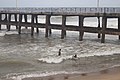
The topography of Pondicherry is the same as that of coastal Tamil Nadu. Pondicherry's average elevation is at sea level and includes a number of sea inlets, referred to locally as "backwaters". Pondicherry experiences extreme coastal erosion as a result of a breakwater constructed in 1989,[10] just to the south of the city. Where there was once a broad, sandy beach, now the city is protected against the sea by a 2-km-long seawall that sits at a height of 8.5 m above sea level. Whilst there was an early seawall made by the French government in 1735, this was not "hard structure coastal defence" so much as an adjunct to the old shipping pier and a transition from the beach to the city.[11]
Today, the seawall consists of rows of granite boulders reinforced every year in an attempt to stop erosion. As a consequence of the seawall, there is severe seabed erosion and turbulence at the coastal margin, resulting in an extreme loss of biodiversity within the critical intertidal zone. Whenever gaps appear as the stones fall into the continually eroding seabed, the government adds more boulders. Pondicherry's seawall has also caused beach erosion to migrate further up the coast, to the fishing villages in Puducherry and Tamil Nadu to the north of the city.[citation needed]
Economy[edit]
In 2012, the Ministry of Power inaugurated the "Smart Grid" project in Puducherry.[12] Farming around Pondicherry includes crops such as rice, pulses, sugarcane, coconuts, and cotton. In 2016, the Pondicherry State Government Employees Central Federation presented a status paper on the fiscal and social crisis in Puducherry to Union Home Minister Rajnath Singh. The report stated that a "combination of a staggering debt, stagnant tax revenues and rampant misappropriation of funds has throttled the economy of the Union Territory" and called for measures on a war footing to "deliver good governance and end corruption".[13]
Climate[edit]
The climate of Pondicherry is classified by the Köppen climate classification as tropical wet and dry,[14] similar to that of coastal Tamil Nadu. Summer lasts from April to early June, when maximum temperatures may reach 41 °C (106 °F). The average maximum temperature is 36 °C (97 °F). Minimum temperatures are in the order of 28–32 °C (82–90 °F). This is followed by a period of high humidity and occasional thundershowers from June until September.
The northeast monsoon sets in during the middle of October, and Pondicherry gets the bulk of its annual rainfall during the period from October to December. The annual average rainfall is 1,355 millimetres or 53 inches.[15] Winters are very warm, with highs of 30 °C (86 °F) and lows often dipping to around 18–20 °C (64–68 °F).
| Climate data for Pondicherry Airport | |||||||||||||
|---|---|---|---|---|---|---|---|---|---|---|---|---|---|
| Month | Jan | Feb | Mar | Apr | May | Jun | Jul | Aug | Sep | Oct | Nov | Dec | Year |
| Record high °C (°F) | 33.2 (91.8) |
35.2 (95.4) |
37.2 (99.0) |
41.8 (107.2) |
43.1 (109.6) |
41.7 (107.1) |
40.7 (105.3) |
40.2 (104.4) |
38.6 (101.5) |
37.9 (100.2) |
36.3 (97.3) |
32.5 (90.5) |
43.1 (109.6) |
| Average high °C (°F) | 29.0 (84.2) |
30.0 (86.0) |
31.2 (88.2) |
32.8 (91.0) |
34.6 (94.3) |
35.8 (96.4) |
34.5 (94.1) |
33.9 (93.0) |
33.1 (91.6) |
31.5 (88.7) |
29.8 (85.6) |
29.0 (84.2) |
32.1 (89.8) |
| Average low °C (°F) | 21.9 (71.4) |
22.5 (72.5) |
23.8 (74.8) |
25.9 (78.6) |
26.8 (80.2) |
26.5 (79.7) |
25.7 (78.3) |
25.2 (77.4) |
24.9 (76.8) |
24.5 (76.1) |
23.6 (74.5) |
22.6 (72.7) |
24.5 (76.1) |
| Record low °C (°F) | 17.1 (62.8) |
17.3 (63.1) |
18.8 (65.8) |
21.9 (71.4) |
21.9 (71.4) |
21.5 (70.7) |
21.6 (70.9) |
21.4 (70.5) |
21.5 (70.7) |
19.6 (67.3) |
16.5 (61.7) |
17.1 (62.8) |
16.5 (61.7) |
| Average rainfall mm (inches) | 12.3 (0.48) |
22.2 (0.87) |
19.3 (0.76) |
7.8 (0.31) |
48.6 (1.91) |
48.0 (1.89) |
89.5 (3.52) |
132.3 (5.21) |
132.8 (5.23) |
273.9 (10.78) |
350.0 (13.78) |
217.3 (8.56) |
1,354 (53.3) |
| Average rainy days | 0.9 | 0.9 | 0.8 | 0.4 | 1.9 | 2.8 | 5.3 | 6.7 | 6.5 | 10.3 | 11.8 | 6.8 | 55.0 |
| Source: India Meteorological Department (record high and low up to 2010)[16][17] | |||||||||||||
Demographics[edit]


According to the 2011 census of India, Pondicherry had a population of 244,377, with 124,947 females and 119,430 males. It had an average literacy rate of 80.6%, with male literacy at 84.6% and female literacy at 76.7%. Ten per cent of the population was under six years of age.[1]
The majority of people in Pondicherry speak Tamil. There is a community of French people and a number of French institutions, such as a French consulate, the French Institute of Pondicherry, and L'Alliance française.[18]
Civic administration[edit]
The city of Puducherry comprises two municipalities, Puducherry and Uzhavarkarai. Both the municipalities and the commune panchayats in the Union Territory of Puducherry function under the administrative control of the local administration department.[19] The Puducherry municipality, under the Puducherry district, comprises the former communes of Puducherry and Mudaliarpet, with its headquarters in Puducherry. It has a total of 42 wards spread over an area of 19.46 km2 (7.51 sq mi).[20] Wards 1–10 are north of the city; wards 11–19 are in Boulevard Town, and the remaining wards are southwest of the city centre.[21]
Urban agglomeration[edit]

| Local bodies | Area | Population |
|---|---|---|
| Pondicherry Municipality | 19 km2 (7.3 sq mi) | 241,773 |
| Oulgaret Municipality | 36 km2 (14 sq mi) | 300,028 |
| Villianur Census Town and Outgrowth | 67,254 | |
| Ariyankuppam Town and Outgrowth | 47,454 | |
| Total | 293 km2 (113 sq mi) | 629,509 |
Data according to the 2011 census[edit]
There are two proposals by the Puducherry government, firstly to merge Pondicherry and Oulgaret municipalities and upgrade the Pondicherry municipality into a '"municipal corporation", and secondly to upgrade Villianur and Ariyankuppam commune panchayats into municipalities, which would increase the Pondicherry region's urban area around 155 km2 (60 sq mi) of the total 292 km2 (113 sq mi).
Transport[edit]


Road[edit]
Pondicherry is connected to Chennai via the East Coast Road through Mahabalipuram.[22] There are daily bus services from several main stops from Chennai. The Pondicherry Road Transport Corporation runs buses within the city and outside.[23] The Tamil Nadu State Transport Corporation operates air-conditioned bus services from Chennai to Pondicherry.[24]
Rail[edit]
Pondicherry is connected by train to all major Indian cities, such as Chennai, Delhi, Kolkata (Howrah), Mumbai, Kanyakumari, Hyderabad, Nagpur, Bhubaneswar, Bengaluru, Visakhapatnam, and Mangalore.[25][26] Moreover, Villupuram Junction, which is at a distance of around 24 mi (39 km), is connected to several other Indian cities.[27]
Air[edit]
Pondicherry Airport is located at Lawspet, an Assembly Constituency in the Union Territory of Puducherry.[28] It has direct flights to Hyderabad[28] and Bengaluru.
Tourism[edit]


Pondicherry is a tourist destination. The city has many colonial buildings, churches, temples, and statues which, combined with the town planning and French-style avenues in the old districts, still preserve much of the colonial ambiance.
While the sea is a draw for tourists, Pondicherry no longer has the sandy beaches that once graced its coastline.[citation needed] The breakwater to the harbour and other hard structures constructed on the shore caused extreme coastal erosion, and the sand from Pondicherry's Promenade Beach has disappeared entirely. As a result of the city's seawall and groyne construction, the beaches further up the coast to the north have also been lost. An enormous deposition of sand has accrued to the south of the harbour breakwater, but this is not a large beach and is not easily accessible from the city.[citation needed]
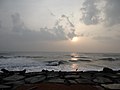
The government has taken steps to construct a reef and re-dose the sand. The sea is accessible by a small patch of land at Promenade Beach (Goubert Avenue).[29] Moreover, the beach is one of the cleanest in India and has been selected for Blue Flag certification.[30]

The Sri Aurobindo Ashram, located on Rue de la Marine, is one of the most important ashrams in India, founded by the freedom fighter and spiritual philosopher Sri Aurobindo.[31] Auroville (City of Dawn) is an "experimental" township located 8 km (5.0 mi) northwest of Pondicherry.
There are a number of old and large churches in Pondicherry, most of which were built in the 18th and 19th centuries. A number of heritage buildings and monuments are present around Promenade Beach, such as the Children's Park and Dupleix Statue, Gandhi statue, Nehru statue, Le Café, French War Memorial, 19th Century Light House, Bharathi Park, Governors Palace, Romain Rolland Library, Legislative Assembly, Pondicherry Museum, and the French Institute of Pondicherry at Saint Louis Street.
Puducherry Botanical Gardens is located south of the New Bus Stand. Chunnambar Backwater resort is 8 km (5.0 mi)from Pondicherry, along Cuddalore Main Road. This tropical resort is flanked by a creek on one side.
Arulmigu Manakula Vinayagar Devasthanam on Manakula Vinayagar Street is a Hindu temple to Ganesha. Sri Manakula Vinayagar Temple was in existence before the French came and settled in Pondicherry in 1666.[32]
Sengazhuneer Amman at Veerampattinam village is one of the oldest temples in Pondicherry, situated about 7 km (4.3 mi) away from the city centre. The car festival conducted in mid-August is famous in Puducherry and other neighbouring states. The festival takes place on the fifth Friday since the commencement of the Tamil month of 'Aadi' every year.[citation needed]
Thirukaameeswarar Temple is located in a rural town called Villianur,[33] located about 10 km (6.2 mi), towards Villupuram.

Notable people[edit]
Leaders[edit]
- V. Subbiah, trade union leader and freedom fighter
Literature and arts[edit]
- Bharathidasan, Tamil poet
- Anandaraj, actor
- Kalki Koechlin, actress
Science and technology[edit]
- S. Somasegar, former senior vice-president, Microsoft
- Ganapathi Thanikaimoni, scientist and director of the Palynology laboratory of the French Institute of Pondicherry
- Yvonne Artaud, French educationalist and psychologist
- Navi Radjou, innovation and leadership strategist based in Silicon Valley[34]
Armed forces[edit]
- Jacques Lauriston (1768–1828), senior-ranking military commander in the French Army, born in Pondicherry
Popular culture[edit]
- Prince Pondicherry, a character from Roald Dahl's Charlie and the Chocolate Factory, named after the city
- Pondicherry is the setting for the first third of Yann Martel's 2001 Booker Prize-winning novel, Life of Pi. A portion of the subsequent film adaptation was filmed there.[35]
- Lee Langley's 1995 novel, A House in Pondicherry is set here.[36]
Educational institutions[edit]
- Jawaharlal Institute of Postgraduate Medical Education and Research
- Lycée français de Pondichéry
- Pondicherry University
- Puducherry Technological University
Gallery[edit]

Rue De La Marine
Rue Saint Louis

Nehru Statue

Gate leading into Manakula Vinayagar Temple in White Town

Tanjore painting of Manakula Vinayagar

Devotees with Elephant Lakshmi in Manakula Vinayagar Temple

Beach by the Bay of Bengal
Bay of Bengal
Early morning by the Bay of Bengal


See also[edit]
- Karaikal, India
- Mahé, India
- Manakula Vinayagar Temple
- Pondicherry urban area
- Yanam, India
References[edit]
- ↑ 1.0 1.1 "District Census Handbook: Puducherry" (PDF). Census of India. Office of the Registrar General & Census Commissioner, India. pp. 86–87. Retrieved 11 February 2019.
- ↑ "Bill to rename Pondicherry as Puducherry passed". The Hindu. 22 August 2006. Retrieved 2 May 2016.
- ↑ "Pondicherry history".
- ↑ Francis, Peter (2002). Asia's Maritime Bead Trade: 300 B.C. to the Present. University of Hawaii Press. ISBN 978-0-8248-2332-0.
- ↑ Worrall, Jill (11 April 2016). "Peace, love and a French flavour in Pondicherry, South India". www.stuff.co.nz. Retrieved 2 May 2016.
- ↑ Israel, Jonathan (1989). Dutch Primacy in World Trade 1585-1740. New York: Oxford University Press. ISBN 0198227299.
- ↑ Chand, Hukam. History Of Medieval India, 202.
- ↑ https://eparlib.nic.in/bitstream/123456789/55921/1/lsd_01_06_06-04-1954.pdf page 22
- ↑ https://eparlib.nic.in/bitstream/123456789/55921/1/lsd_01_06_06-04-1954.pdf page 23
- ↑ "The Story of Pondicherry's Eroding Coastline in a Single Image". 16 October 2008.
- ↑ "Geography of Pondicherry, Geographical Location of Pondicherry, Pondicherry Natural Features". Archived from the original on 16 September 2009. Retrieved 22 June 2009.
- ↑ "Smart grid project inaugurated". Puducherry. The Hindu. 20 October 2012. Retrieved 23 October 2012.
- ↑ "Report paints grim picture of Puducherry's economy". The Hindu. 18 October 2016. Retrieved 28 October 2017.
- ↑ "Climate: Pondicherry – Climate graph, Temperature graph, Climate table". Climate-Data.org. Retrieved 6 October 2013.
- ↑ "Government of India". Archived from the original on 26 July 2009. Retrieved 10 July 2009.
- ↑ "Pondicherry Climatological Table Period: 1971–2000". India Meteorological Department. Retrieved 11 April 2015.
- ↑ "Ever recorded Maximum and minimum temperatures up to 2010" (PDF). India Meteorological Department. Archived from the original (PDF) on 16 March 2014. Retrieved 11 April 2015.
- ↑ "Pondicherry: Forever France? by Anand Jha". 21 July 2012. Archived from the original on 21 July 2012. Retrieved 3 October 2013.
- ↑ "Local Administration Departments Know Puducherry: Government of Puducherry". www.py.gov.in. Retrieved 9 April 2020.
- ↑ "Municipality Details – Pondicherry Municipality – The Union Territory of Puducherry". www.pdymun.in. Retrieved 9 April 2020.
- ↑ Town and Country Planning Department, Pondicherry, India: City Development Plan – Pondicherry, Final Report, March 2007, S. 159 Archived 19 June 2009 at the Wayback Machine
- ↑ Ramakrishnan, Deepa (23 February 2012). "After a decade on fast lane, ECR is set to expand". The Hindu. Chennai. Retrieved 16 September 2012.
- ↑ "20 buses launched in urban routes". The Hindu. Puducherry. 8 June 2010. Retrieved 19 September 2012.
- ↑ V, Venkatasubramanian (19 February 2010). "A boon to Kancheepuram unit of TNSTC". The Hindu. Kancheepuram. Archived from the original on 24 February 2010. Retrieved 15 September 2012.
- ↑ "Delhi-Puducherry train link from July 3". The Hindu. 25 June 2011. Retrieved 16 September 2012.
- ↑ "Changes in train timings". The Hindu. Puducherry. 13 September 2012. Retrieved 16 September 2012.
- ↑ "Puducherry to Villupuram – 3 ways to travel via bus, and line 16116 train". Rome2rio. Retrieved 28 January 2020.
- ↑ 28.0 28.1 "Puducherry back on aviation map; services to Hyderabad launched". The Economic Times. 16 August 2017. Retrieved 12 February 2019.
- ↑ M, Kavya (30 August 2018). "Artificial reef helps restore lost Pondy beach". Deccan Chronicle. Retrieved 28 January 2020.
- ↑ Dominique, Bosco (6 June 2019). "Beach in Puducherry selected for blue flag certification". The Times of India. Retrieved 28 January 2020.
- ↑ "Sri Aurobindo". Retrieved 19 July 2019.
- ↑ "Arulmigu Manakula Vinayagar Temple". Retrieved 19 July 2019.
- ↑ "About Pondicherry". India tourism. Retrieved 19 July 2019.
- ↑ "Frugal innovation: From East to West and back again". Archived from the original on 19 January 2015. Retrieved 19 January 2015.
- ↑ "Life of Pi". The Guardian. 20 December 2012. Retrieved 19 July 2019.
- ↑ "Of Love Lost". India Today. Retrieved 19 July 2019.
- Articles containing French-language text
- Articles with unsourced statements from June 2019
- Articles with unsourced statements from April 2019
- Articles with unsourced statements from March 2023
- Pondicherry (city)
- Cities and towns in Puducherry district
- Municipalities of Puducherry
- Indian union territory capitals
- 1674 establishments in the French colonial empire
- Populated places established in 1674