Sonamura
Sonamura
সোনামুড়া | |
|---|---|
Town | |
| Coordinates: 23°28′N 91°16′E / 23.47°N 91.27°ECoordinates: 23°28′N 91°16′E / 23.47°N 91.27°E | |
| Country | |
| State | Tripura |
| District | Sipahijala district |
| Government | |
| • Type | Nagar Panchayat |
| • Body | Sonamura Nagar Panchayat |
| • Chairman | Smt. Sarada Chakraborty (BJP) |
| Elevation | 15 m (49 ft) |
| Population (2015) | |
| • Total | 12,592 |
| Languages | |
| • Official | Bengali, Kokborok, English |
| Time zone | UTC+5:30 (IST) |
| PIN | 799131 |
| Vehicle registration | TR |
| Website | tripura |
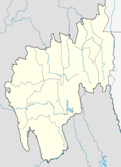
Sonamura is a town and a Nagar Panchayat in the Indian state of Tripura. It is the headquarter of Sonamura Subdivision in Sipahijala district lies on the border with Bangladesh to the east of Comilla.
Demographics[edit | edit source]
As of the 2011 India census, Sonamura had a population of 10,074. Males constituted 51% of the population and females 49%. Sonamura has an average literacy rate of 73%, higher than the national average of 59.5%: male literacy is 77%, and female literacy is 68%. In Sonamura, 11% of the population is under 6 years of age.
Politics[edit | edit source]
Sonamura’s assembly constituency is part of Tripura West (Lok Sabha constituency). [1]
See also[edit | edit source]
References[edit | edit source]
- ↑ "Assembly Constituencies - Corresponding Districts and Parliamentary Constituencies" (PDF). Tripura. Election Commission of India. Archived from the original (PDF) on 8 November 2005. Retrieved 8 October 2008.
