

Pakhanjur
Pakhanjore | |
|---|---|
Town | |
 Pakhanjur Location in Chhattisgarh, India  Pakhanjur Pakhanjur (India) | |
| Coordinates: 20°02′05″N 80°37′32″E / 20.0346544°N 80.6255085°E | |
| Country | India |
| State | Chhattisgarh |
| District | Kanker |
| Government | |
| • Type | Nagar Panchayat (Notified Area Council) |
| • Body | Nagar Panchayat Pakhanjur |
| • Council President | Narayan Saha (BJP) |
| • Sub-Divisional Magistrate | Anjor Singh Paikra |
| • Additional Superintendent of Police | Rakesh Kumar Kurre (IPS) |
| • Sub-Divisional Police Officer | Ravi Kumar Kujur |
| Population (2011)[1] | |
| • Total | 10,201 |
| Language | |
| • Official | Hindi,[2] Chhattisgarhi[3] |
| • Others | Bengali |
| Time zone | UTC+5:30 (IST) |
| PIN | 494 776 |
| Telephone code | 91 7844 |
| Vehicle registration | CG 19 |
| Sex ratio | 991 ♂/900♀ |
Pakhanjur, also known as Pakhanjore, is a town, nagar panchayat, and the headquarters of the eponymous tehsil in the Kanker District of Chhattisgarh State in India.[1] According to the 2011 Census of India, it is the second largest town in the district by population, only second to the district headquarters Kanker. It is located 120 km (75 mi) south-west of Kanker and 47 km (29 mi) west of the block headquarters Koyalibeda.[4]
Name[edit | edit source]
The name of the town is written as "पखांजूर" in Devanagari script,[5] however it is transliterated as Pakhanjur[6] and Pakhanjore[7] in English, the former notably supported by Indian Census sources[8][9] and the latter by Dandakaranya Project report submitted to Rajya Sabha in August 1974.[10]
History[edit | edit source]
During the pre-independence era, the entire area covered by the Pakhanjur tehsil today along with the Bande and Koyalibeda tehsils and parts of Abujhmarh, formed the erstwhile Paralkot jagir. In 1825, the region became the theatre of a tribal uprising led by Gaind Singh, a tribal leader and the zamindar of Paralkot, against the British Raj. Popularly known as the Paralkot Rebellion, the uprising saw the rebels fight against the exploitation and injustices meted out to the natives by the foreign powers. It ended with the capture and execution by hanging of the revered tribal leader on 20 January 1825. Subsequently, he came to be honoured as the first martyr of Chhattisgarh.[11][12]
In 1958, the Pakhanjur Colony that forms the heart of the town, was established along with the neighbouring settlements of Kapsi and Bande under the Dandakaranya Project.[10]
Dandakaranya project[edit | edit source]
The Indian government created the Dandakaranya Development Authority in 1958 to assist refugees from East Pakistan (now Bangladesh). It constructed the Bhaskel Dam and Paralkot reservoir (Kherkatta Dam), woodworking centers at Jagdalpur, Boregaon, and Umerkote, and roads and railways in the refugee resettlement areas, including the Balangir-Kozilum railway project. A factory that mainly produces aircraft engines is located at Sunabeda. The National Mineral Development Corporation works iron ore at Bailadila. Important towns are Jagdalpur, Bhawanipatna, and Koraput. The project was known as the Dandakaranya Project.[13]
A large number of people from East Pakistan, which is now Bangladesh were settled at the newly formed 133 settlements, each designated as a Paralkot Village (PV) and numbered from PV 1 to PV 133, in areas of Kapsi, Pakhanjur and Bande. These people suffered heavy losses leaving hundreds of acres of agricultural fields and adjusted with very small land for survival.[14]
Geography[edit | edit source]
Pakhanjur tehsil is surrounded by the Durgukondal tehsil and Mohla Manpur district to the north, Koyalibeda tehsil to the east, Bande tehsil to the south and the Gadchiroli district of Maharashtra to the west.
Deforestation[edit | edit source]
People are suffering a lot because of deforestation here. Every year lakhs of trees are cut down for industrial purpose. The famous green belt is slowly turning into an orange area which is dangerous. New programs need to be initiated to promote greenery and planting of trees.[15]
Demographics[edit | edit source]
As of the 2011 Indian Census, Pakhanjur nagar panchayat had a population of 10,201, consisting of 5,370 males and 4,831 females. The population of children aged 0–6 was 1,207; 11.83% of the population. The male:female sex ratio is 900, lower than the state average of 991. The child sex ratio in Pakhanjur is around 904 compared to the state average of 969. The effective literacy rate of people seven years and above is 86.86%; the male literacy is around 91.64% and the female literacy rate is 81.54%. There were 2,332 households. The Scheduled Castes and Scheduled Tribes populations were 508 and 1,201 respectively.[1]
Religion[edit | edit source]
The overwhelming majority of the population of Pakhanjur is Hindu, with Christians, Sikhs and Muslims having small populations.[9]
Government and politics[edit | edit source]
Administration[edit | edit source]

The sub-district code of Pakhanjur tehsil is 03354 and the total number of villages is 299.[16]
Post office[edit | edit source]
The pin-code of Pakhanjur is 494776, and the sub post office is Pakhanjur Camp.[17][18]
Healthcare[edit | edit source]
Hospitals[edit | edit source]
Economy[edit | edit source]
The Hahaladdi Iron Ore Deposit project site is connected through State highway SH-6.[21]
There is no major industrial activity in Pakhanjur tehsil. Small-scale industries include a handful of rice mills and stone crusher plants. Majority of the population and hence the economy is primarily dependent on agriculture.[citation needed]
Pakhanjur town has two prominent bazaars namely, the old market and the new market, as the trade and commerce centres. Kapsi and Bande are the other important bazaars of the tehsil.[22]
Attractions[edit | edit source]


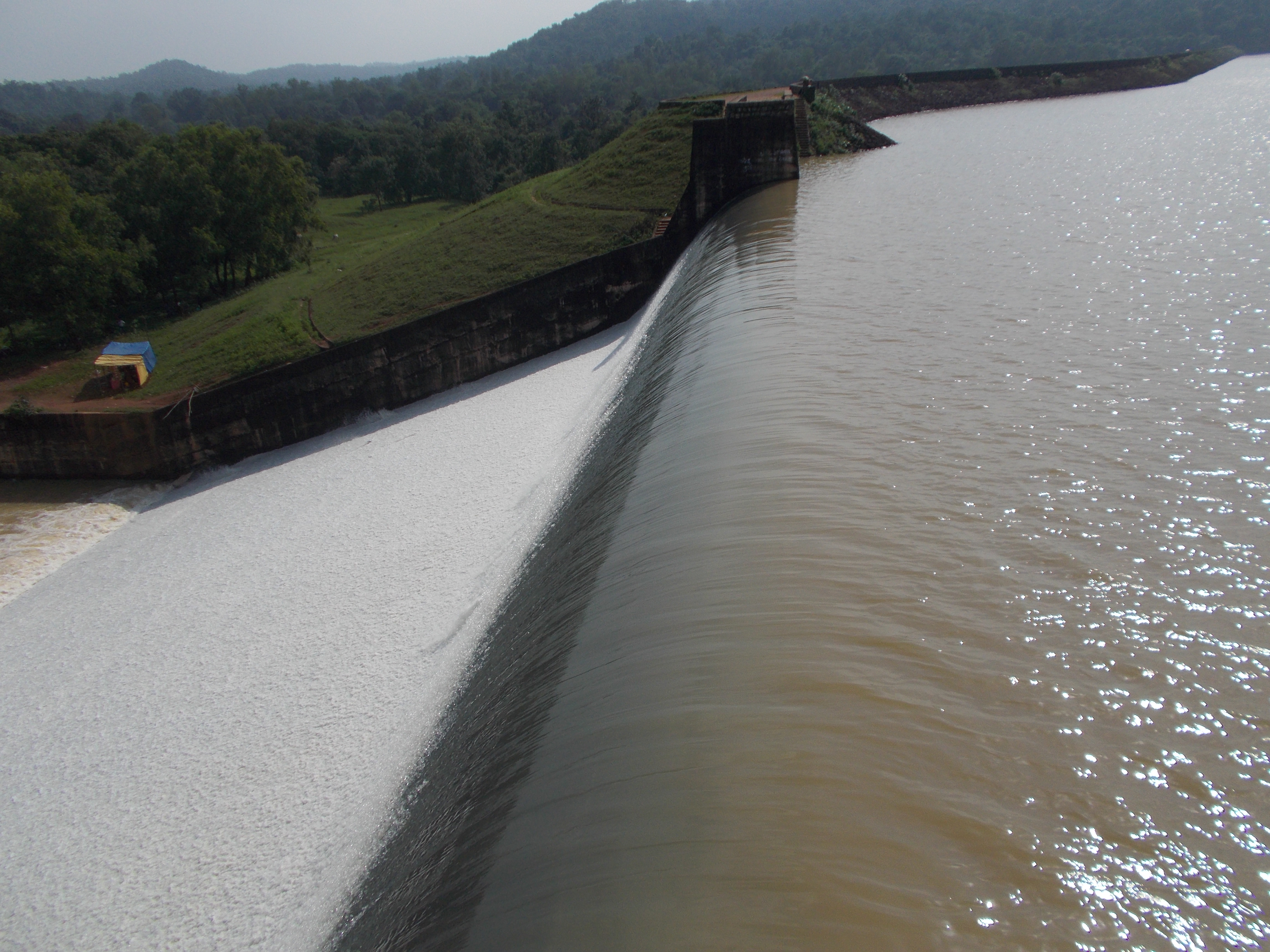
- Kherkatta Reservoir which is situated near Kapsi.[23]
- Nara Narayan Mela or Pakhanjur Mela[24]
- Nara Narayana Sevashram
- Kali Mandir
- Shiv Mandir
- Satsang Vihar, Shri Shri Thakur Anukulchandra Temple, situated in the heart of Pakhanjur
- Ram Vatika
- Satyanand Nagar
Transport[edit | edit source]
Roadways[edit | edit source]
Pakhanjur is situated on Chhattisgarh State Highway 25 and is only connected by road from Durg, Raipur, Kanker, Dalli Rajhara, Bhanupratappur, Jagdalpur, Gadchiroli and Chandrapur. Its distance is 250 km (160 mi) from the state capital Raipur.
Railways[edit | edit source]
Railway services are non-existent in Pakhanjur. The nearest major railway station is Durg Jn. (DURG) on the Howrah–Nagpur–Mumbai line 190 km (120 mi) from Pakhanjur. The nearest local railway station is Keoti (KETI) on the Dalli Rajhara–Jagdalpur line 62 km (39 mi) away.
There has been demands from various quarters to construct the proposed Gadchiroli-Bhanupratappur rail line via Durgukondal, Kapsi and Pakhanjur instead of via Manpur.[25][26][27] This proposed line when completed, would serve as an alternative route between Nagpur and Vishakhapatnam — one of the busiest freight corridors in the country — by linking the Nagpur-Wadsa-Gadchiroli line to the Bhanupratappur-Jagdalpur-Vishakhapatnam line. If the demands are met, it would provide a much needed impetus to the development of this area.[28]
In May 2022, the Ministry of Railways (India) provided in-principle approval for the survey of this line. It subsequently allocated a budget of ₹3.37 crore (US$470,000) for the survey, though the route and deadline were yet undecided.[25][29] Given the importance of this project, the South Eastern Central Railway zone fast-tracked the regulatory process and in August of the same year floated tenders for the final location survey and preparation of the Detailed Project Report.[30][31] The survey was commissioned soon after.
Airports[edit | edit source]
Pakhanjur's nearest commercial airport with regular scheduled flights is Swami Vivekananda Airport, Raipur 250 km (160 mi) away.
Education[edit | edit source]
- Industrial Training Institute (ITI)[32]
- Govt. Veer Gaind Singh College Pakhanjore[33]
Sports[edit | edit source]
The Netaji Subhash Chandra Bose Stadium Pakhanjur is famous for football and cricket tournaments.[34][35] The stadium hosts annual celebrations on Independence Day (15 August) and Republic Day (26 January). All cultural and extracurricular activities are performed in the stadium and inter-school competitions are organised between them.
See also[edit | edit source]
References[edit | edit source]
- ↑ 1.0 1.1 1.2 "Census 2011 - Pakhanjur". censusindia.gov.in. Retrieved 16 March 2022.
- ↑ "52nd Report of the Commissioner for Linguistic Minorities in India" (PDF). nclm.nic.in. Ministry of Minority Affairs. Archived from the original (PDF) on 25 May 2017. Retrieved 7 December 2018.
- ↑ Mishra, Ritesh; Sahay, Abhinav (15 August 2020). "Chhattisgarh CM writes to PM Narendra Modi, demands inclusion of Chhattisgarhi dialect in 8th Schedule". Hindustan Times. Retrieved 4 April 2022.
- ↑ Layout of Koyelibeda Block. Archived from the original on 8 September 2006. Retrieved 25 February 2015.
- ↑ Gupta, Ashish Kumar (17 July 2023). "Kanker: पखांजूर सीएएफ कैंप में आधी रात अचानक होने लगी फायरिंग इधर-उधर भागने लगे जवान मचा हड़कंप". Nai Dunia (in हिन्दी). Retrieved 20 July 2023.
- ↑ "Chhattisgarh: Food inspector, 2 more, booked over emptying of reservoir to find lost phone". ANI News. 1 June 2023. Retrieved 20 July 2023.
- ↑ "Chhattisgarh: 5 of family killed in house wall collapse in Kanker". The Economic Times. PTI. 15 August 2022. Retrieved 20 July 2023.
- ↑ "Registrar General and Census Commissioner of India". Census of India. Retrieved 20 July 2023.
- ↑ 9.0 9.1 9.2 "C-01: Population by religious community". Census of India. Retrieved 20 July 2023.
- ↑ 10.0 10.1 Official Name Pakhanjore (PDF). p. 1. Archived from the original (PDF) on 14 February 2021. Retrieved 11 April 2015.
- ↑ "Great Man Gen Singh". Archived from the original on 4 March 2016. Retrieved 25 February 2015.
- ↑ Singh, Bhupendra (11 May 2020). "आजादी के लिए 195 साल पहले फांसी पर चढ़े थे छत्तीसगढ़ के पहले शहीद परलकोट के जमींदार गैंदसिंह - First martyr of Chhattisgarh Zamindar Gaind Singh of Chhattisgarh was hanged for independence 195 years ago". Jagran (in हिन्दी). Retrieved 24 July 2023.
- ↑ Design report of Paralkote (PDF). 1971. Retrieved 30 October 2017.
- ↑ Villages Established (PDF). Archived from the original (PDF) on 25 February 2015. Retrieved 25 February 2015.
- ↑ "तुंहर दुआर योजना:वन विभाग ने लोगों को बांटे फलदार पौधे". Dainik Bhaskar (in हिन्दी). 15 January 2022. Retrieved 15 April 2022.
- ↑ "Pakhanjore code". Retrieved 2 January 2020.
- ↑ "Pincode". Retrieved 25 February 2015.
- ↑ Pakhanjore camp post office. 2017. p. 1. Archived from the original on 7 November 2017. Retrieved 30 October 2017.
- ↑ "Pakhanjore Hospital". Archived from the original on 2 April 2015. Retrieved 31 March 2015.
- ↑ Vandana Hospital (PDF). RSBY. p. 23.
- ↑ Hahaladdi Iron Ore Deposit (PDF). p. 1. Archived from the original (PDF) on 14 July 2015. Retrieved 14 July 2015.
- ↑ "लॉकडॉउन:पखांजूर, कापसी और बांदे में पूर्ण तालाबंदी का दिखा असर". Dainik Bhaskar. Retrieved 24 July 2023.
- ↑ Water source, of farmers (31 March 2021). "Pakhanjore Dam". More life changer. Retrieved 31 March 2021.
- ↑ "News in Naiduniya". 15 January 2015. Retrieved 11 April 2015.
- ↑ 25.0 25.1 "Extension of railway line to connect Kanker with Maharashtra". The Times of India. 10 August 2022. ISSN 0971-8257. Retrieved 20 July 2023.
- ↑ "रेलवे लाइन बनने पर सीधे महाराष्ट्र से जुड़ जाएगा कांकेर:नक्सल प्रभावित भानुप्रतापपुर गढ़चिरौली रेल लाइन सर्वे के लिए 3.37 करोड़ रुपए मंजूर". Danik Bhaskar (in हिन्दी). Retrieved 20 July 2023.
- ↑ "केंद्रीय बजट में प्रोजेक्ट:भानुप्रतापपुर-गढ़चिरौली तक 133 किमी रेल लाइन बिछेगी". Dainik Bhaskar (in हिन्दी). Retrieved 20 July 2023.
- ↑ "SECR exploring new route to Southern India via Gadchiroli, orders final location survey". www.thehitavada.com. 4 September 2022. Retrieved 20 July 2023.
- ↑ "SECR exploring new route to Southern India via Gadchiroli, orders final location survey". www.thehitavada.com. Retrieved 20 July 2023.
- ↑ "New rly line cutting jumbo route in offing". The Times of India. 26 August 2022. ISSN 0971-8257. Retrieved 20 July 2023.
- ↑ "Integrated Budgetary Financial Figures for South East Central Railway" (PDF). Indian Railways. Retrieved 20 July 2023.
- ↑ "Industrial Training Institute (ITI)". Archived from the original on 25 February 2015. Retrieved 25 February 2015.
- ↑ "Govt. Veer Gaind Singh College Pakhanjore". Archived from the original on 25 February 2015. Retrieved 25 February 2015.
- ↑ "Pakhanjur stadium". Retrieved 12 March 2015.
- ↑ "पखांजूर का स्टेडियम फिर से होगा "नेताजी" के नाम पर, भाजपा के शासनकाल में कर दिया गया था "मुखर्जी" के नाम". The Rural Press (in हिन्दी). 4 June 2022. Retrieved 25 July 2023.