Kuntala Waterfall
| Kuntala Waterfall | |
|---|---|
 Kuntala waterfalls | |
| Location | Kuntala, Adilabad district, Telangana |
| Coordinates | 19°17′06″N 78°30′11″E / 19.285°N 78.503°ECoordinates: 19°17′06″N 78°30′11″E / 19.285°N 78.503°E |
| Type | Waterfall |
| Total height | 50 meters |
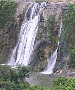
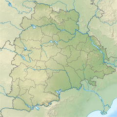
Kuntala Waterfall is a waterfall in the Indian state of Telangana, located on Kadam river in Neradigonda mandal of Adilabad district.[1] It is the highest waterfall in the state with a height of 50 meters.[2]
These waterfalls are in the dense forests inhabited by the Gonds. Kunta in Gondi and Telugu means pond. Kuntalu means several ponds. The waterfall originates from a confluence of several ponds that lead to the river Kadem.[3]
Formed by the Kadam River, Kuntala falls cascades down through two steps and can be seen as two separate adjacent falls after the peak rains. It is one of the famous one day outings from Hyderabad. There is a motorable road until the entry point of the falls, from where steps are available to reach the bottom of the falls. The falls are about 10 minutes (one way) walk from the entry point.
Transportation[edit | edit source]
Public transport is available until Neredikonda, from where private vehicles can be hired. Nirmal and Adilabad are base stations. The nearest Railway station is Adilabad, from Hyderabad Krishna Express will reach. Other waterfalls in the area include Gayatri Waterfalls and Pochera Falls.
References[edit | edit source]
- ↑ AuthorTelanganaToday. "Get wooed by wonderful waterfalls of Telangana". Telangana Today. Retrieved 18 May 2019.
- ↑ Shanker, C. R. Gowri (20 August 2016). "Waterfalls come alive in Telangana after years-long gap". Deccan Chronicle. Retrieved 18 May 2019.
- ↑ Brown, Charles Philip (27 January 2018). "A Telugu-English Dictionary. New ed., thoroughly rev. and brought up to date...2nd ed". Dsalsrv02.uchicago.edu. Retrieved 27 January 2018.

