Junnardeo
Junnardeo
जुन्नारदेव Jamai | |
|---|---|
city | |
| Coordinates: 22°12′N 78°35′E / 22.2°N 78.58°ECoordinates: 22°12′N 78°35′E / 22.2°N 78.58°E | |
| Country | India |
| State | Madhya Pradesh |
| District | Chhindwara |
| Elevation | 748 m (2,454 ft) |
| Population (2001) | |
| • Total | 22,426 |
| Languages | |
| • Official | Hindi and English |
| • Regional | Hindi, English and Marathi |
| Time zone | UTC+5:30 (IST) |
| PIN | 480551 |
| ISO 3166 code | IN-MP |
| Vehicle registration | MP-28 |
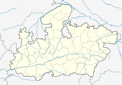
Junnardeo is a city and a municipality in Chhindwara district in the Indian state of Madhya Pradesh, India. Junnardeo is the head office of the Kanhan area of WCL. It has Asia's largest Coal Wash Plant.
Educational Institutions[edit]
University/College[edit]
| University/College | Type | Location |
|---|---|---|
| Government Junnardeo College, Junnardeo | Government | Tehsil Road, Kalimati, Junnardeo |
| Vidya Devi Shukla Mahavidyalaya, Junnardeo (VDSM) | Private | Ward Number - 03, Tamia Bypass Road, Near Police Station, Junnardeo |
| Government Industrial Training Institute, Junnardeo (Govt ITI) | Government | Hanotiya Road, Junnardeo |
School[edit]
| School | Type | Location |
|---|---|---|
| Shri Nandlal Sood Government School of Excellence, Junnardeo | Government | Tamia Bypass Road, Junnardeo |
| Government Kanya Shiksha Parisar, Junnardeo | Government | Tamia Bypass Road, Junnardeo |
| Pandit Ravishankar Shukla Higher Secondary School, Junnardeo | Private | Cinema Road, Junnardeo |
| Eklavya Model Residential School, Junnardeo | Government | Near Sukri Railway Gate, Sukri, Junnardeo |
| Kendriya Vidyalaya, Junnardeo | Government | Umariya Fadali, Junnardeo |
| Kendriya Vidyalaya, Barkuhi | Government | Junnardeo Road (SH 19B), Barkuhi, Chandameta-Butaria |
| Step Forward Public School, Junnardeo | Private | Ward Number - 14, Hanotiya Road, Junnardeo |
| Gyan Sagar Public School, Junnardeo | Private | Ward Number - 17, Near Sukri Forest Naka, Khajari Road, Junnardeo |
| Kanhan Valley School, Dungariya | Private | Near GMOs Office, Dungariya |
| Government Higher Secondary School, Hanotiya | Government | Hanotiya Road (SH 19B), Hanotiya |
Demographics[edit]
As of 2001[update] Madhya Pradesh, India census,[1]
Tourism Attractions[edit]
- Patalkot
- Patalkot Sunset Point
- Junnardeo Hills
- Tamia Hills
- Junnardeo Pahali Payari
- Hinglaj Mata Mandir
- Lodheshwar Mahadev Mandir
Notable people[edit]
- Mudgal Singh Nanhe Singh, Freedom Fighter
Geography[edit]
Junnardeo is located at 22°12′N 78°35′E / 22.2°N 78.58°E.[2] It has an average elevation of 748 metres (2,454 feet).[citation needed]
References[edit]
- ↑ "Census of India 2001: Data from the 2001 Census, including cities, villages and towns (Provisional)". Census Commission of India. Archived from the original on 16 June 2004. Retrieved 1 November 2008.
- ↑ Falling Rain Genomics, Inc – Jamai

