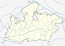
Anuppur
Anuppur
अनूपपुर | |
|---|---|
Town | |
| Coordinates: 23°06′N 81°41′E / 23.1°N 81.68°ECoordinates: 23°06′N 81°41′E / 23.1°N 81.68°E | |
| Country | |
| State | Madhya Pradesh |
| District | Anuppur |
| Government | |
| • Type | Nagar Palika Parishad |
| • Body | Member of the Legislative Assembly (India) |
| • District Magistrate | Ms.Sonia Meena IAS |
| Elevation | 505 m (1,657 ft) |
| Population (2020) | |
| • Total | 26,397 |
| Languages | |
| • Official | Hindi |
| Time zone | UTC+5:30 (IST) |
| PIN | 484224 |
| Telephone code | 07659 |
| Vehicle registration | MP 65 |
| Website | anuppur |
Anuppur is a City in northeastern Madhya Pradesh state of central India. It is the administrative headquarters of the Anuppur tehsil and Anuppur District. Previously, it was in Shahdol district.
Geography[edit]
Anuppur is located at 23°06′N 81°41′E / 23.1°N 81.68°E.[1] It has an average elevation of 505 metres (1,656 feet). The Son River and some of its tributaries run through Anuppur.[2] According to 2001 Census, the total population of Anuppur District is 667155, out of which 309624 are Scheduled tribes and 48376 are Scheduled castes. In this manner, Anuppur District is a tribal dominated district. Kotma is the largest city/town and Municipality in Anuppur district.
Demographics[edit]
As of 2011[update] India census,[3] Anuppur district has a population of 749,521. 2001 to 2011 population growth rate is 12.3%. Males constitute 52% of the population and females 48%.
References[edit]
- ↑ Falling Rain Genomics, Inc - Anuppur
- ↑ Anuppur District Ground Water Information Booklet
- ↑ "Census of India 2011: Data from the 2001 Census, including cities, villages and towns (Provisional)". Census Commission of India. Archived from the original on 16 June 2004. Retrieved 1 November 2008.
