.svg)
Himachal Pradesh
Himachal Pradesh
ਹਿਮਾਚਲ ਪ੍ਰਦੇਸ਼ | |
|---|---|
State of India | |
 Kangra Fort, 20 kilometres from the town of Dharamshala | |
.svg) A map showing where the location of Himachal Pradesh is in the Republic of India | |
 Topographic map of Himachal | |
| Country | |
| Region | North India |
| Government | |
| • Legislature | Unicameral (295* seats) |
| Area | |
| • Total | 56,019 km2 (21,629 sq mi) |
| Population (2011) | |
| • Total | 6,856,509 |
| Time zone | UTC+05:30 (IST) |
| Official languages | Punjabi · English |
| ^* | |
Himachal Pradesh (Hindi: हिमाचल प्रदेश) (Punjabi: ਹਿਮਾਚਲ ਪ੍ਰਦੇਸ਼) is a state in northern India. Shimla is the capital of Himachal Pradesh. It covers an area of 56,019 km² (21,629 mi²), although the border with China is still disputed. The land contains high mountains. In traditional Indian geography it falls under the North Indian zone. It borders the disputed Indian-occupied territory of Indian-administered Kashmir to the north.
Himachal Pradesh was part of Indian Punjab before 1966.
The State of HP is divided into three Divisions, namely Mandi Division, Kangra Division, Shimla Division. The divisions are further sub-divided into 12 districts. These are further divided into 55 sub-divisions, 82 tehsils and 35 sub-tehsils.[1]
Gallery

Mountain peaks in Lahul, Himachal Pradesh
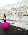
Lady near Rothang Pass, Himachal Pradesh


Provincial symbols of Himachal Pradesh
- Indian state flag of Himachal Pradesh (proposed).jpg
Provincial flag of Himachal Pradesh
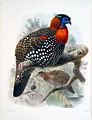
Western tragopan, provincial bird of Himachal Pradesh

Snow Leopard, provincial animal of Himachal Pradesh
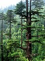
Cedrus deodara, provincial tree of Himachal Pradesh

Pink Rhododendron , provincial flower of Himachal Pradesh


.jpg)
References
- ↑ "Himachal At A Glance - Information Data centre". Archived from the original on 2013-08-16. Retrieved 2013-07-25.
Other websites
- Official website of Himachal Pradesh Government Archived 2011-07-09 at the Wayback Machine
- Himachal Pradesh Development Report Archived 2010-05-02 at the Wayback Machine
- Himachal Tourism Website
- Himachal's Daily news website
| States | Andhra Pradesh • Arunachal Pradesh • Assam • Bihar • Chhattisgarh • Goa • Gujarat • Haryana • Himachal Pradesh • Jharkhand • Karnataka • Kerala • Madhya Pradesh • Maharashtra • Manipur • Meghalaya • Mizoram • Nagaland • Odisha • Punjab • Rajasthan • Sikkim • Tamil Nadu • Telangana • Uttar Pradesh • Uttarakhand • West Bengal | |
|---|---|---|
| Union Territories | ||