->Sadads m link Rural poverty using Find link |
AgnesOppen5 (talk | contribs) refine lead and cleaned formatting for accuracy |
||
| Line 3: | Line 3: | ||
{{Infobox settlement | {{Infobox settlement | ||
| name = Karmatar | | name = Karmatar | ||
| other_name = Karmatar Vidyasagar | | other_name = Karmatar Vidyasagar | ||
| nickname = | | nickname = | ||
| Line 11: | Line 9: | ||
| image_alt = | | image_alt = | ||
| image_caption = | | image_caption = | ||
| | | image_map = Karmatanr Vidyasagar in Jamtara (Jharkhand).svg | ||
| coordinates = {{coord|24|5|2|N|86|42|8|E|display=inline,title}} | | coordinates = {{coord|24|5|2|N|86|42|8|E|display=inline,title}} | ||
| subdivision_type = Country | | subdivision_type = Country | ||
| Line 65: | Line 60: | ||
==History== | ==History== | ||
[[Ishwar Chandra Vidyasagar]], the scholar-social reformer and a key figure in the [[Bengal Renaissance]] came to Karmatar in 1873 and spent more than 18 years of his life here.<ref>{{cite web| url = http://www.telegraphindia.com/1030826/asp/jharkhand/story_2298943.asp |title= Vidyasagar legacy lost in sands of time | publisher= The Telegraph, 26 August 2003 | access-date = 26 December 2015}}</ref> In 1974, the railway station at Karmatar was renamed Vidyasagar.<ref>{{cite book| url = https://books.google.com/books?id=H3g9BAAAQBAJ&q=karmatar+renamed+Vidyasagar&pg=PR16 |title= Vidyasagar:The Life and After-life of an Eminent Indian| first= Brian A.|last= Hatcher| work= Introduction|date= 7 August 2014| isbn= 978-0-415-73630-5 | publisher= Routledge, Taylor and Francis Group, 912 Tolstoy House, 15-17 Tolstoy Marg, Connaught Place, New Delhi- 110 001| access-date = 26 December 2015}}</ref> | [[Ishwar Chandra Vidyasagar]], the scholar-social reformer and a key figure in the [[Bengal Renaissance]], came to Karmatar in 1873 and spent more than 18 years of his life here.<ref>{{cite web| url = http://www.telegraphindia.com/1030826/asp/jharkhand/story_2298943.asp | archive-url = https://web.archive.org/web/20030908203854/http://www.telegraphindia.com/1030826/asp/jharkhand/story_2298943.asp | url-status = dead | archive-date = 8 September 2003 |title= Vidyasagar legacy lost in sands of time | publisher= The Telegraph, 26 August 2003 | access-date = 26 December 2015}}</ref> In 1974, the railway station at Karmatar was renamed [[Vidyasagar railway station|Vidyasagar]].<ref>{{cite book| url = https://books.google.com/books?id=H3g9BAAAQBAJ&q=karmatar+renamed+Vidyasagar&pg=PR16 |title= Vidyasagar:The Life and After-life of an Eminent Indian| first= Brian A.|last= Hatcher| work= Introduction|date= 7 August 2014| isbn= 978-0-415-73630-5 | publisher= Routledge, Taylor and Francis Group, 912 Tolstoy House, 15-17 Tolstoy Marg, Connaught Place, New Delhi- 110 001| access-date = 26 December 2015}}</ref> | ||
==Geography== | ==Geography== | ||
Karmatar is located at {{coord|24|5|2|N|86|42|8|E}}.<ref>{{cite web| url = http://wikimapia.org/2120452/Karmatar | title= Karmatar (Karmatar) | work= Jharkhand| publisher= Wikimapia | access-date = 26 December 2015}}</ref> | Karmatar is located at {{coord|24|5|2|N|86|42|8|E}}.<ref>{{cite web| url = http://wikimapia.org/2120452/Karmatar | title= Karmatar (Karmatar) | work= Jharkhand| publisher= Wikimapia | access-date = 26 December 2015}}</ref> | ||
Jamtara district in the south-eastern part of [[Santhal Pargana division|Santhal Parganas]] is a rolling upland tract. The [[Barakar River|Barakar]] separates it from the [[Chota Nagpur | Jamtara district in the south-eastern part of [[Santhal Pargana division|Santhal Parganas]] is a rolling upland tract. The [[Barakar River|Barakar]] separates it from the [[Chota Nagpur Plateau]] and the [[Ajay River|Ajay]], flows in from [[Deoghar district]] in the west, drains the district, forms the border between Jharkhand and West Bengal for some distance and flows into West Bengal in the east.<ref>{{cite web| url = https://archive.org/details/dli.csl.3120/page/n1/mode/2up |title = Bihar District Gazetteers: Santhal Parganas| first= P.C.|last=Roychoudhury | work= Chaoter I: General |publisher= Secretariat Press, Patna, 1965 | access-date = 21 October 2020}}</ref> | ||
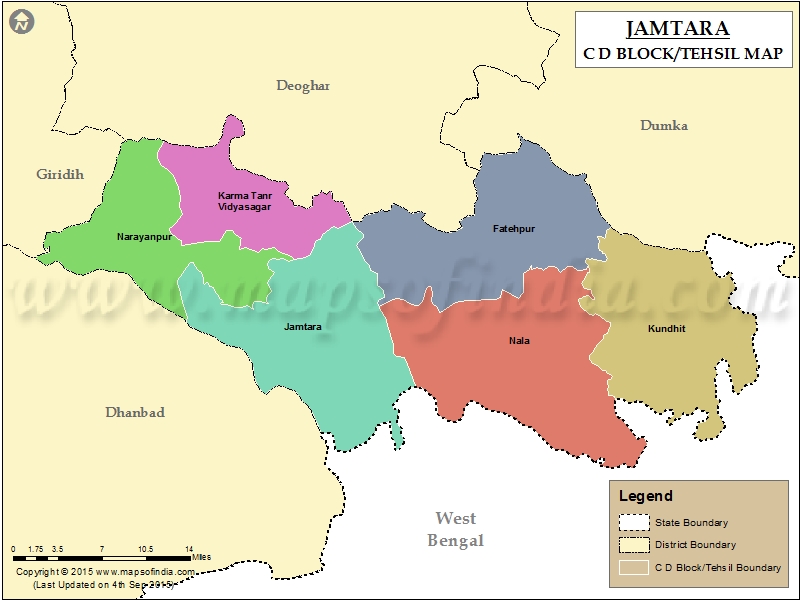
Karmatanr CD block is bounded by [[Margomunda]], [[Karon, Deoghar|Karon]] and [[Sarath, Deoghar|Sarath]] CD blocks in Deoghar district on the north, [[Jamtara block|Jamtara]] CD block on the east, and [[Narayanpur block|Narayanpur]] CD block on the south and west.<ref>{{cite web | url = https://www.mapsofindia.com/maps/jharkhand/tehsil/jamtara-tehsil-map.jpg | title = Jamtara CD block/ tehsil map|publisher = Maps of India | access-date = 22 October 2020}}</ref><ref>{{cite web | url = https://www.mapsofindia.com/maps/jharkhand/tehsil/deogarh.html | title = Deoghar CD block/ tehsil map |publisher = Maps of India | access-date = 22 October 2020}}</ref> | Karmatanr CD block is bounded by [[Margomunda]], [[Karon, Deoghar|Karon]] and [[Sarath, Deoghar|Sarath]] CD blocks in Deoghar district on the north, [[Jamtara block|Jamtara]] CD block on the east, and [[Narayanpur block|Narayanpur]] CD block on the south and west.<ref>{{cite web | url = https://www.mapsofindia.com/maps/jharkhand/tehsil/jamtara-tehsil-map.jpg | title = Jamtara CD block/ tehsil map|publisher = Maps of India | access-date = 22 October 2020}}</ref><ref>{{cite web | url = https://www.mapsofindia.com/maps/jharkhand/tehsil/deogarh.html | title = Deoghar CD block/ tehsil map |publisher = Maps of India | access-date = 22 October 2020}}</ref> | ||
Karmatanr CD block has an area of 175.00 km<sup>2</sup>.<ref name=census2011>{{cite web| url = https://censusindia.gov.in/2011census/dchb/2018_PART_B_DCHB_JAMTARA.pdf |title = District Census Handbook, Jamtara, Series 21, Part XII B| work= Page 55: Rural PCA – CD block wise village primary census abstract, 2011 census |publisher= Directorate of Census Operations Jharkhand | access-date = 22 October 2020}}</ref>[[Karmatanr, Jamtara|Karmatanr]] police station serves this block.<ref>{{cite web| url = https://jhpolice.gov.in/jamtara | title = District Police Profile - Jamtara| publisher = Jharkhand Police| access-date = 22 October 2020}}</ref> Headquarters of this CD block is at [[Karmatanr, Jamtara|Karmatanr]].<ref>{{cite web| url = https://censusindia.gov.in/2011census/dchb/2018_PART_B_DCHB_JAMTARA.pdf |title = District Census Handbook, Jamtara, Series 21, Part XII B| work= Map of Jamtara on the third page|publisher= Directorate of Census Operations Jharkhand | access-date = 22 October 2020}}</ref> | Karmatanr CD block has an area of 175.00 km<sup>2</sup>.<ref name=census2011>{{cite web| url = https://censusindia.gov.in/2011census/dchb/2018_PART_B_DCHB_JAMTARA.pdf |title = District Census Handbook, Jamtara, Series 21, Part XII B| work= Page 55: Rural PCA – CD block wise village primary census abstract, 2011 census |publisher= Directorate of Census Operations Jharkhand | access-date = 22 October 2020}}</ref>[[Karmatanr, Jamtara|Karmatanr]] police station serves this block.<ref>{{cite web| url = https://jhpolice.gov.in/jamtara| title = District Police Profile - Jamtara| publisher = Jharkhand Police| access-date = 22 October 2020| archive-date = 12 November 2020| archive-url = https://web.archive.org/web/20201112201126/https://www.jhpolice.gov.in/jamtara| url-status = dead}}</ref> Headquarters of this CD block is at [[Karmatanr, Jamtara|Karmatanr]].<ref>{{cite web| url = https://censusindia.gov.in/2011census/dchb/2018_PART_B_DCHB_JAMTARA.pdf |title = District Census Handbook, Jamtara, Series 21, Part XII B| work= Map of Jamtara on the third page|publisher= Directorate of Census Operations Jharkhand | access-date = 22 October 2020}}</ref> | ||
Karmatar CD block has 18 panchayats and 151 villages.<ref name=admin>{{cite web | url= http://jamtara.nic.in/blk_panchayat.html | title= Jamtara district of Jharkhand | work= Blocks and Panchayats | publisher= Jamtara district administration | access-date= 26 December 2015 | archive-url= https://web.archive.org/web/20151227014358/http://jamtara.nic.in/blk_panchayat.html | archive-date= 27 December 2015 | url-status= dead }}</ref> | Karmatar CD block has 18 panchayats and 151 villages.<ref name=admin>{{cite web | url= http://jamtara.nic.in/blk_panchayat.html | title= Jamtara district of Jharkhand | work= Blocks and Panchayats | publisher= Jamtara district administration | access-date= 26 December 2015 | archive-url= https://web.archive.org/web/20151227014358/http://jamtara.nic.in/blk_panchayat.html | archive-date= 27 December 2015 | url-status= dead }}</ref> | ||
| Line 95: | Line 90: | ||
===Language and religion=== | ===Language and religion=== | ||
{{bar box | |||
|title=Religions in Karmatand block (2011)<ref name="Religion">{{cite web |title=Table C-01 Population By Religion - Jharkhand|url=https://censusindia.gov.in/nada/index.php/catalog/11377/download/14490/DDW20C-01%20MDDS.XLS|website=census.gov.in|publisher=[[Registrar General and Census Commissioner of India]]}}</ref> | |||
|titlebar=#Fcd116 | |||
|left1=Religion | |||
|right1=Percent | |||
|float=left | |||
|bars= | |||
{{bar percent|[[Hinduism]]|darkorange|48.97}} | |||
{{bar percent|[[Islam]]|green|42.81}} | |||
{{bar percent|[[Sarnaism|Sarna]]|maroon|7.54}} | |||
{{bar percent|[[Christianity in Jharkhand|Christianity]]|dodgerblue|0.60}} | |||
{{bar percent|Other or not stated|black|0.08}} | |||
}} | |||
[[ | {{Pie chart | ||
|caption = Languages of Karmatand block (2011)<ref name="language"/> | |||
|label1 = [[Khortha language|Khortha]] |value1 = 67.09 |color1 = red | |||
|label2 = [[Santali language|Santali]] |value2 = 18.26 |color2 = darkturquoise | |||
|label3 = [[Urdu]] |value3 = 8.32 |color3 = green | |||
|label4 = [[Bengali language|Bengali]] |value4 = 3.63 |color4 = orchid | |||
|label5 = [[Hindi]] |value5 = 1.77 |color5 = orange | |||
|other = y |other-label = Others |other-color = grey | |||
}} | |||
At the time of the 2011 census, 67.09% of the population spoke [[Khortha language|Khortha]], 18.26% [[Santali language|Santali]], 8.32% [[Urdu]], 3.63% [[Bengali language|Bengali]] and 1.77% [[Hindi]] as their first language.<ref name="language">{{Cite web |url=https://censusindia.gov.in/nada/index.php/catalog/10207/download/13319/DDW-C16-STMT-MDDS-2000.XLSX|title=Table C-16 Population by Mother Tongue: Jharkhand|website=censusindia.gov.in|publisher=[[Registrar General and Census Commissioner of India]]}}</ref> | |||
==Rural poverty== | ==Rural poverty== | ||
Latest revision as of 20:50, 22 November 2025
Karmatar
Karmatar Vidyasagar | |
|---|---|
Community development block | |
.svg) | |
| Coordinates: 24°5′2″N 86°42′8″E / 24.08389°N 86.70222°E | |
| Country |  India India |
| State | Jharkhand |
| District | Jamtara |
| Government | |
| • Type | Federal democracy |
| Area | |
| • Total | 175.00 km2 (67.57 sq mi) |
| Elevation | 201 m (659 ft) |
| Population (2011) | |
| • Total | 115,266 |
| • Density | 660/km2 (1,700/sq mi) |
| Languages | |
| • Official | Hindi, Urdu |
| Literacy (2011) | |
| • Total literates | 53,844 (58.16%) |
| Time zone | UTC+5:30 (IST) |
| PIN | 815352 (Karmatar) |
| Telephone/STD code | 06433 |
| Vehicle registration | JH-21 |
| Lok Sabha constituency | Dumka |
| Vidhan Sabha constituency | Jamtara and Sarath |
| Website | jamtara |
Karmatar is a community development block that forms an administrative division in the Jamtara Sadar subdivision of the Jamtara district, Jharkhand state, India. It is located 15 km from Jamtara, the district headquarter.
History[edit | edit source]
Ishwar Chandra Vidyasagar, the scholar-social reformer and a key figure in the Bengal Renaissance, came to Karmatar in 1873 and spent more than 18 years of his life here.[1] In 1974, the railway station at Karmatar was renamed Vidyasagar.[2]
Geography[edit | edit source]
Karmatar is located at 24°5′2″N 86°42′8″E / 24.08389°N 86.70222°E.[3]
Jamtara district in the south-eastern part of Santhal Parganas is a rolling upland tract. The Barakar separates it from the Chota Nagpur Plateau and the Ajay, flows in from Deoghar district in the west, drains the district, forms the border between Jharkhand and West Bengal for some distance and flows into West Bengal in the east.[4]
Karmatanr CD block is bounded by Margomunda, Karon and Sarath CD blocks in Deoghar district on the north, Jamtara CD block on the east, and Narayanpur CD block on the south and west.[5][6]
Karmatanr CD block has an area of 175.00 km2.[7]Karmatanr police station serves this block.[8] Headquarters of this CD block is at Karmatanr.[9]
Karmatar CD block has 18 panchayats and 151 villages.[10]
Panchayats of Karmatar CD block are: Alagchuan, Bagber, Baradaha, Barmundi, Birajpur, Dumariya, Karmatanr, Kuruwa, Mattanr, Mohanpur, Nawadih, Phofnad, Sikarposni, Sitakatta, Subdidih, Tarabahal, Tarkojori and Tetulbandha.[10]
Demographics[edit | edit source]
Population[edit | edit source]
As per the 2011 Census of India Karmatanr CD block had a total population of 115,266, of which 109,398 were rural and 5,868 were urban. There were 58,937 (51%) males and 56,329 (49%) females. Population below 6 years was 22,693. Scheduled Castes numbered 7,737 (6.71%) and Scheduled Tribes numbered 21,767 (18.88%).[7]
Census town in Karmatanr CD block is (2011 census figure in brackets): Karmatanr (5,868).[7]
Large village (with 4,000+ population) in Karmatanr CD block is (2011 census figure in brackets): Karua (4,031).[7]
Literacy[edit | edit source]
As of 2011[update] census, CD block Wise Primary Census Abstract Data the total number of literates in Karmatar Vidyasagar CD Block was 53,844 (58.16% of the population over 6 years) out of which 33,798 (63%) were males and 20,046 (37%) were females. The gender disparity (the difference between female and male literacy rates) was 26%.[7]
See also – List of Jharkhand districts ranked by literacy rate
| Literacy in CD Blocks of Jamtara district |
|---|
| Narayanpur – 55.72% |
| Karmatanr – 58.16% |
| Jamtara – 66.31% |
| Nala – 64.63% |
| Fatehpur – 65.66% |
| Kundhit – 63.64% |
| Source: 2011 Census: CD Block Wise Primary Census Abstract Data |
Language and religion[edit | edit source]
At the time of the 2011 census, 67.09% of the population spoke Khortha, 18.26% Santali, 8.32% Urdu, 3.63% Bengali and 1.77% Hindi as their first language.[12]
Rural poverty[edit | edit source]
60-70% of the population of Jamtara district were in the BPL category in 2004–2005, being in the same category as Ranchi and Dumka districts.[13] Rural poverty in Jharkhand declined from 66% in 1993–94 to 46% in 2004–05. In 2011, it has come down to 39.1%.[14]
Economy[edit | edit source]
Livelihood[edit | edit source]
in Karmatanr CD block
- Cultivators (29.6%)
- Agricultural labourers (51.3%)
- Household industries (1.79%)
- Other Workers (17.3%)
In Karmatanr CD block in 2011, amongst the class of total workers, cultivators numbered 13,727 and formed 29.62%, agricultural labourers numbered 23,787 and formed 51.33%, household industry workers numbered 828 and formed 1.79% and other workers numbered 7,998 and formed 17.26%. Total workers numbered 48,098 and formed 41.73% of the total population. Non-workers numbered 67,168 and formed 58.27% of total population.[15]
Note: In the census records a person is considered a cultivator, if the person is engaged in cultivation/ supervision of land owned. When a person who works on another person's land for wages in cash or kind or share, is regarded as an agricultural labourer. Household industry is defined as an industry conducted by one or more members of the family within the household or village, and one that does not qualify for registration as a factory under the Factories Act. Other workers are persons engaged in some economic activity other than cultivators, agricultural labourers and household workers. It includes factory, mining, plantation, transport and office workers, those engaged in business and commerce, teachers and entertainment artistes.[16]
Infrastructure[edit | edit source]
There are 145 inhabited villages in Karmatanr CD block. In 2011, 114 villages had power supply. 142 villages had well water (covered/ uncovered), 139 villages had hand pumps, and all villages had drinking water facility. 7 villages had post offices, 7 villages had sub post offices, 5 villages had telephones (land lines), 4 villages had public call offices and 105 villages had mobile phone coverage. 144 villages had pucca (paved) village roads, 6 villages had bus service (public/ private), 2 villages had railway stations, 1 village had autos/ modified autos, and 24 villages had tractors. 5 villages had bank branches, 1 village had agricultural credit societies, 2 villages had cinema/ video halls, 33 villages had public distribution system, 21 villages had weekly haat (market) and 66 villages had assembly polling stations.[17]
Backward Regions Grant Fund[edit | edit source]
Jamtara district is listed as a backward region and receives financial support from the Backward Regions Grant Fund. The fund created by the Government of India is designed to redress regional imbalances in development. As of 2012, 272 districts across the country were listed under this scheme. The list includes 21 districts of Jharkhand.[18][19]
Transportation[edit | edit source]
The Ranigunj-Kiul section of the Howrah-Delhi main line was in position in 1871. It provided rail link for Karmatar.[20]
Education[edit | edit source]
Karmatanr CD block had 24 villages with pre-primary schools, 119 villages with primary schools, 51 villages with middle schools, 4 villages with secondary schools, 2 villages with senior secondary schools, 26 villages with no educational facility.[17]
.*Senior secondary schools are also known as Inter colleges in Jharkhand
Healthcare[edit | edit source]
Karmatanr CD block had 2 villages with primary health centres, 8 villages with primary health subcentres, 7 villages with maternity and child welfare centres, 1 village with veterinary hospital, 2 villages with family welfare centres, 16 villages with medicine shops.[17]
.*Private medical practitioners, alternative medicine etc. not included
References[edit | edit source]
- ↑ "Vidyasagar legacy lost in sands of time". The Telegraph, 26 August 2003. Archived from the original on 8 September 2003. Retrieved 26 December 2015.
- ↑ Hatcher, Brian A. (7 August 2014). Vidyasagar:The Life and After-life of an Eminent Indian. Routledge, Taylor and Francis Group, 912 Tolstoy House, 15-17 Tolstoy Marg, Connaught Place, New Delhi- 110 001. ISBN 978-0-415-73630-5. Retrieved 26 December 2015.
{{cite book}}:|work=ignored (help) - ↑ "Karmatar (Karmatar)". Jharkhand. Wikimapia. Retrieved 26 December 2015.
- ↑ Roychoudhury, P.C. "Bihar District Gazetteers: Santhal Parganas". Chaoter I: General. Secretariat Press, Patna, 1965. Retrieved 21 October 2020.
- ↑ "Jamtara CD block/ tehsil map". Maps of India. Retrieved 22 October 2020.
- ↑ "Deoghar CD block/ tehsil map". Maps of India. Retrieved 22 October 2020.
- ↑ 7.0 7.1 7.2 7.3 7.4 "District Census Handbook, Jamtara, Series 21, Part XII B" (PDF). Page 55: Rural PCA – CD block wise village primary census abstract, 2011 census. Directorate of Census Operations Jharkhand. Retrieved 22 October 2020.
- ↑ "District Police Profile - Jamtara". Jharkhand Police. Archived from the original on 12 November 2020. Retrieved 22 October 2020.
- ↑ "District Census Handbook, Jamtara, Series 21, Part XII B" (PDF). Map of Jamtara on the third page. Directorate of Census Operations Jharkhand. Retrieved 22 October 2020.
- ↑ 10.0 10.1 "Jamtara district of Jharkhand". Blocks and Panchayats. Jamtara district administration. Archived from the original on 27 December 2015. Retrieved 26 December 2015.
- ↑ "Table C-01 Population By Religion - Jharkhand". census.gov.in. Registrar General and Census Commissioner of India.
- ↑ 12.0 12.1 "Table C-16 Population by Mother Tongue: Jharkhand". censusindia.gov.in. Registrar General and Census Commissioner of India.
- ↑ "Rural Poverty in Jharkhad, India" (PDF). Table I: Spatial Distribution of Poverty in Jharkhand. Munich Personal RePEc Archive. Retrieved 22 October 2020.
- ↑ "Eliminating poverty" (PDF). Jharkhand government. Retrieved 22 October 2020.
- ↑ "District Census Handbook, Jamtara" (PDF). Tables 34, 30 Series 21, Part XII A, 2011 census. Directorate of Census Operations, Jharkhand. Retrieved 22 October 2020.
- ↑ "District Census Handbook 2011 Jamtara, Series 21 Part XII A" (PDF). Page 10: Census Concepts. Directorate of Census Operations, Jharkhand. Retrieved 22 October 2020.
- ↑ 17.0 17.1 17.2 "District Census Handbook, Jamtara, 2011, Series 21, Part XII A" (PDF). Pages 427-429 Appendix I: Village Directory. Directorate of Census Operations, Jharkhand. Retrieved 22 October 2020.
- ↑ "Backward Regions Grant Funds: Programme Guidelines" (PDF). Ministry of Panchayati Raj, Government of India. Archived from the original (PDF) on 30 October 2017. Retrieved 23 September 2017.
- ↑ "Backward Regions Grant Fund". Press Release, 14 June 2012. Press Information Bureau, Government of India. Retrieved 23 September 2017.
- ↑ "IR History: Early days II". Chronology of Railways in India, Part 2, 1870-1899. IRFCA. Retrieved 26 December 2015.