

>Rsjaffe m clean up, typo(s) fixed: , → , , ’s → 's |
enhance details per sources and cleaned formatting as per guidelines |
||
| Line 1: | Line 1: | ||
{{Short description|Suburb of Mumbai, Maharashtra, India}} | |||
{{for|the village in Pune district|Borivali, Mawal}} | {{for|the village in Pune district|Borivali, Mawal}} | ||
{{Use dmy dates|date=July 2017}} | {{Use dmy dates|date=July 2017}} | ||
{{Use Indian English|date=July 2017}} | {{Use Indian English|date=July 2017}} | ||
{{Infobox settlement | {{Infobox settlement | ||
| name | | name = Borivali | ||
| native_name | | native_name = | ||
| native_name_lang | | native_name_lang = | ||
| other_name | | other_name = Borivli | ||
| settlement_type | | settlement_type = Suburb | ||
| image_skyline | | image_skyline = Skyscrapers of Mumbai viewed from 'National Park, Borivili.jpg | ||
| image_caption | | image_caption = Borivali skyline from [[Sanjay Gandhi National Park]] | ||
| map_caption | | map_caption = | ||
| pushpin_map | | pushpin_map = India#India Maharashtra#India Mumbai | ||
| pushpin_label_position | | pushpin_label_position = right | ||
| pushpin_map_caption | | pushpin_map_caption = Location of Borivali in [[Mumbai]] | ||
| coordinates | | coordinates = {{coord|19.23|N|72.86|E|display=inline,title}} | ||
| subdivision_type | | subdivision_type = Country | ||
| subdivision_name | | subdivision_name = {{flag | India}} | ||
| subdivision_type1 | | subdivision_type1 = [[States and territories of India|State]] | ||
| subdivision_type2 | | subdivision_type2 = [[List of districts of India|District]] | ||
| subdivision_type3 | | subdivision_type3 = City | ||
| subdivision_name1 | | subdivision_name1 = [[Maharashtra]] | ||
| subdivision_name2 | | subdivision_name2 = [[Mumbai Suburban district|Mumbai Suburban]] | ||
| subdivision_name3 | | subdivision_name3 = [[Mumbai]] | ||
| established_title | | established_title = <!-- Established --> | ||
| established_date | | established_date = | ||
| founder | | founder = | ||
| named_for | | named_for = | ||
| government_type | | government_type = [[Municipal Corporation]] | ||
| governing_body | | governing_body = [[Brihanmumbai Municipal Corporation]] (MCGM) | ||
| unit_pref | | unit_pref = Metric | ||
| area_total_km2 | | area_total_km2 = | ||
| elevation_footnotes | | elevation_footnotes = | ||
| elevation_m | | elevation_m = | ||
| population_total | | population_total = 1 Million | ||
| population_as_of | | population_as_of = 2011 | ||
| population_footnotes | | population_footnotes = {{Citation needed|date=June 2022}} | ||
| population_density_km2 | | population_density_km2 = auto | ||
| demographics_type1 | | demographics_type1 = Languages | ||
| demographics1_title1 | | demographics1_title1 = Official | ||
| timezone1 | | timezone1 = [[Indian Standard Time|IST]] | ||
| utc_offset1 | | utc_offset1 = +5:30 | ||
| postal_code_type | | postal_code_type = [[Postal Index Number|PIN]] | ||
| postal_code | | postal_code = Borivali (East) - 400066<br>Borivali (West) - 400091, 400092<br>Mandapeshwar (Borivali) - 400103 | ||
| area_code | | area_code = 022 | ||
| area_code_type | | area_code_type = | ||
| registration_plate | | registration_plate = MH 47 | ||
| blank1_name_sec1 | | blank1_name_sec1 = [[Lok Sabha]] constituency | ||
| blank1_info_sec1 | | blank1_info_sec1 = [[Mumbai North (Lok Sabha constituency)|Mumbai North]] | ||
| website | | website = | ||
| demographics1_info1 | | demographics1_info1 = [[Marathi language|Marathi]] | ||
| blank2_name_sec1 | | blank2_name_sec1 = [[Vidhan Sabha]] constituency | ||
| blank2_info_sec1 | | blank2_info_sec1 = [[Borivali (Vidhan Sabha constituency)|Borivali]]{{efn|Covers western part of the suburb}}<br>[[Magathane (Vidhan Sabha constituency)|Magathane]]{{efn|Covers eastern part of the suburb}} | ||
| official_name | | official_name = | ||
}} | }} | ||
'''Borivali''' (Pronunciation: [[Help:IPA/Marathi|[boːɾiʋəliː]]]) is a suburb located in northwestern [[Mumbai]], India. Traditionally, tribals and East Indians lived in Borivali. | |||
Attractions include the [[Sanjay Gandhi National Park]], Fish Park, [[Kanheri Caves]], [[Mandapeshwar Caves]], Water Kingdom, the Rushivan and Hanuman Tekdi, with views of the suburbs. | |||
[[Borivali railway station]] is an originating and terminating [[Rail transport|Railway]] Station for [[Mumbai Suburban Railway|Mumbai local trains]] towards [[Churchgate railway station|Churchgate]] in the [[South]] & [[Virar railway station|Virar]] in the [[North]]. Also some express trains halt at this [[Rail transport|rail]] station which provides ease for people [[travel]]ling long distances. | |||
==Demographics== | |||
Borivali has a large population of Marathi people, followed by Gujarati people.<ref>{{cite news|title=BMC polls: How the BJP burrowed into Gujarati-dominated suburbs |last=Rishi |first=Shubir |date=February 24, 2017 |url=https://www.oneindia.com/india/bmc-polls-how-the-bjp-burrowed-into-gujarati-dominated-suburbs-2357493.html}}</ref> | |||
== History == | |||
{{unreferenced section|date=November 2024}} | |||
[[File:KITLV 88162 - Unknown - Reliefs at Borivali in British India - 1897.tif|thumb|Reliefs at Borivali, 1897.]] | |||
[[File:KITLV 88163 - Unknown - Reliefs at Borivali in British India - 1897.tif|thumb|Reliefs at Borivali, 1897.]] | [[File:KITLV 88163 - Unknown - Reliefs at Borivali in British India - 1897.tif|thumb|Reliefs at Borivali, 1897.]] | ||
The names Borivaḻī (बोरिवळी) and Boriyli-gram occur as the name of a place in the 15th-17th-century Marathi-language text ''[[Mahikavatichi Bakhar]]''; these names derive from the term for the [[Indian jujube]] tree (''bor'' in Marathi).<ref>{{cite journal |author=Dipesh Karmarkar |title=Understanding Place Names in 'Mahikavati's Bakhar': A Case of Mumbai-Thane Region |journal=Studies in Indian Place Names |issn=2394-3114 |publisher=Place Names Society of India |location=Mysore |volume=XXXI |year=2012 |url=https://www.researchgate.net/publication/308925531_UNDERSTANDING_PLACE_NAMES_IN_'MAHIKAVATI'S_BAKHAR'_A_CASE_OF_MUMBAI-THANE_REGION |pages=123, 128 }}</ref> | |||
''' | |||
The present-day Borivali has developed from what was once a conglomerate region of smaller settlements, namely Eksar, [[Poisar]], Vazira, [[Shimpoli]], Mandpeshwar, Dattapada, Kanheri, Tulsi, Magathane, and [[Gorai]], which were situated on and around [[Mount Poinsur]], between the [[Dahisar River]] and [[Poisar River]]. | |||
Borivali has developed from what was once a | |||
The pre-historic era's "Mandpeshwar" (“An 8th-century remain of a beautiful Edifice structure, the Mandapeshwar Caves is a rock cut architecture and a Hindu shrine of Lord Shiva located near Borivali IC Colony, at walking distance from Dahisar Railway Station”) and "[[Kanheri Caves|Kanheri caves]]" stand testament to the rich history of this place. Borivali was spelt "Berewlee" by the then ruled India under the [[British Raj]]. It is also spelt and pronounced as "Borivli". | |||
The pre-historic era's "Mandpeshwar" (“An 8th | |||
Borivali is densely populated but continues to retain some | Borivali is densely populated but continues to retain some green cover due to the presence of the [[Sanjay Gandhi National Park]], previously known as the "Borivali National Park", in the east and the [[mangrove]]s in the western end of Borivali. | ||
== Landmarks == | == Landmarks == | ||
One of the many gardens that Borivali boasts of is the Veer Savarkar Udyan on Lokmanya Tilak Road and Rivali Park. It has four entrances from T.P.S. Road, Factory Lane, and Babhai and has a jogging track, a boating area, a children's play garden, and skating. Gorai Udyan is at Gorai Sector-1. I.C.Colony is also home to the Tukaram Ombale Garden/Fish Park, which can be accessed from the Link Road and the I.C. Colony last bus stop.{{citation needed|date=June 2022}} | |||
In 2009, Jhansi Ki Rani Laxmibai Joggers' Park was inaugurated on Link Road, adjacent to the Eskay Resort.<ref>{{Cite web|url=https://timesofindia.indiatimes.com/city/mumbai/Borivli-residents-get-a-joggers-park/articleshow/3932344.cms|title=Borivli residents get a joggers' park|website=[[The Times of India]]}}</ref> The plot measures around 4 acres, has a jogging track surrounding a body of water, where boating facilities have been started, and features slabs with information on various freedom fighters scripted on them, besides seating areas for senior citizens. This Jogger's Park has a small fee for entry. Another Joggers' Park is located in Chikuwadi. | |||
Espee Square is an upcoming business center on Dattapada Road, connected to the Western Express Highway at Borivali East. | |||
Oberoi Sky City is an upcoming township with | Oberoi Sky City is an upcoming township with [[Skyscraper]]s, a mall and a 5-star hotel. | ||
The Orion is an upcoming Business Park on Sardar Vallabhbhai Patel Rd at Borivali | The Orion is an upcoming Business Park on Sardar Vallabhbhai Patel Rd at Borivali West.{{citation needed|date=May 2022}} | ||
== | ==Attractions== | ||
*[[Gorai]] Beach is on the western end of Borivali. One can reach here by crossing [[Gorai Creek]] by ferry. Rickshaw is available on the other side of the ferry. On holidays the beach is full of visitors and locals. Plenty of accommodation options are also available at [[Gorai]] beach.<ref name="MTDC">{{cite web|url=http://www.maharashtratourism.gov.in/mtdc/HTML/MaharashtraTourism/TouristDelight/Beaches/Beaches.aspx?strpage=MarveManoriGorai_beaches.html#|archive-url=https://web.archive.org/web/20071207090650/http://www.maharashtratourism.gov.in/mtdc/HTML/MaharashtraTourism/TouristDelight/Beaches/Beaches.aspx?strpage=MarveManoriGorai_beaches.html|url-status=dead|archive-date=7 December 2007|title=Gorai Beach|access-date=26 March 2012}}</ref><ref>{{Cite web|url=https://www.deccanherald.com/national/west/mumbaikars-will-soon-be-able-to-visit-mangrove-park-in-gorai-1042723.html|title=Mumbaikars will soon be able to visit Mangrove Park in Gorai |date=21 October 2021 }}</ref> | |||
*[[EsselWorld]]: One of Mumbai's largest amusement parks. Post COVID-19 pandemic, this facility stands closed.<ref>{{Cite web|url=http://www.esselworld.in/home.html|title=Esselworld|website=www.esselworld.in|access-date=2017-12-05}}</ref> | |||
*Water Kingdom: Asia's largest water park.<ref>{{Cite web|url=http://www.waterkingdom.in/home.html|title=Water Kingdom - Asia's Largest Theme Water Park|website=www.waterkingdom.in|access-date=2017-12-05}}</ref> | |||
*[[Sanjay Gandhi National Park]] is one of the national parks within the metro limits of a major city, and one of the most visited national parks in the world.{{fact|date=September 2025}} | |||
*[[Our Lady of Immaculate Conception Church, Borivali|Our Lady of Immaculate Conception Church]] – Mount Poinsur, Mandapeshwar, I. C. Colony. – Roman Catholic church | |||
*[[Mandapeshwar Caves]] | |||
*[[Global Vipassana Pagoda]] | |||
*[[Mandapeshwar Caves]] | |||
*[[Kanheri Caves]] | |||
*Gorai Mangrove Park<ref>{{cite web |title=Mumbai’s Gorai Mangrove Park expected to open on May 1 |url=https://indianexpress.com/article/cities/mumbai/mumbais-gorai-mangrove-park-expected-open-may1-9864114/ |website=The Indian Express |language=en |date=2 March 2025}}</ref> | |||
==Education== | |||
* [[Ryan International School]] | |||
* [[VIBGYOR Group of Schools]]<ref>{{Cite web|url=https://www.vibgyorhigh.com/mumbai-borivali.php|title=ICSE {{!}} CBSE School in Borivali, Mumbai - VIBGYOR High|website=www.vibgyorhigh.com|access-date=2017-11-25}}</ref> | |||
* [[Saint Francis D'Assisi High School]] | |||
* [[Mary Immaculate Girls' High School]] | |||
* [[JBCN International School]] | |||
Don Bosco High School and Junior College | |||
St. Anne's Girls High School | |||
== Railway station == | ==Transportation== | ||
Road Ways: Autorickshaws, taxis, BEST buses and trains are the public modes of transport available in and to Borivali. Borivali (east) is well connected with [[Western Express Highway]] while Borivali (west) is linked to the New Link Road. Connectivity has increased with two metro lines set to pass through Borivali: [[Line 2 (Mumbai Metro)|Mumbai Metro Line 2]] and [[Line 7 (Mumbai Metro)|Mumbai Metro Line 7]]. | |||
===Railway station=== | |||
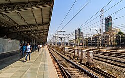
[[File:Mumbai 03-2016 87 Borivali station.jpg|thumb|Borivali railway station]] | [[File:Mumbai 03-2016 87 Borivali station.jpg|thumb|Borivali railway station]] | ||
{{Main|Borivali railway station}} | {{Main|Borivali railway station}} | ||
Borivali railway station is a railway station on the Western line of the [[Mumbai Suburban Railway]] network. It is one of the major platforms of the Mumbai metropolitan city and the biggest railway station in the Western railway. The platform has access to all stations from Churchgate to Virar. The platform has good connectivity for Express trains which goes to different states around the country. It has 10 platforms which were renumbered in 2019, this sudden change created | Borivali railway station is a railway station on the Western line of the [[Mumbai Suburban Railway]] network. It is one of the major platforms of the Mumbai metropolitan city and the biggest railway station in the [[Western Railway zone|Western railway]]. The platform has access to all stations from [[Churchgate]] to [[Virar]]. The platform has good connectivity for Express trains which goes to different states around the country. It has 10 platforms which were renumbered in 2019, this sudden change created much confusion for everyday travelers. With every platform being busy for almost 18–20 hours a day. It is believed to be one of the blind-friendly railway stations on the western railway. Information obtained under the [[Right to Information Act, 2005|Right to Information]] (RTI) Act reveals that it is the most crowded station in Mumbai with around 2.87 lakh passengers traveling from there daily.{{citation needed|date=May 2022}} | ||
==Notable people== | ==Notable people== | ||
* [[Asha Bhosle]], singer | |||
* [[Rohit Sharma]], | * [[Rohit Sharma]], cricketer | ||
* [[Haribhai Parthibhai Chaudhary]], politician, National Leader of the [[Bharatiya Janata Party]] | |||
* [[Jaywant Dalvi]], Marathi author | * [[Jaywant Dalvi]], Marathi author | ||
* [[Drashti Dhami]], TV actress | |||
* [[Bhavya Gandhi]], TV actor | |||
* [[Avdhoot Gupte]], Marathi classical singer | |||
* [[Bose Krishnamachari]], Malayali painter | |||
* [[Dhondutai Kulkarni]], Hindustani classical singer | * [[Dhondutai Kulkarni]], Hindustani classical singer | ||
* [[Ram Naik]], UP Governor, former minister | |||
* [[Ratnakar Pai]], Hindustani classical singer | * [[Ratnakar Pai]], Hindustani classical singer | ||
* [[Rohan Shah]], actor | |||
* [[Rohan Shah]], actor | |||
* [[Vinod Tawde]], Member of Legislative Assembly, Minister | * [[Vinod Tawde]], Member of Legislative Assembly, Minister | ||
* [[ | * [[Disha Vakani]], TV actress | ||
==See also== | ==See also== | ||
| Line 158: | Line 138: | ||
*[[Kandivali]] | *[[Kandivali]] | ||
*[[Dahisar]] | *[[Dahisar]] | ||
== References == | == References == | ||
{{notelist}} | |||
{{Reflist}} | {{Reflist}} | ||
| Line 167: | Line 147: | ||
[[Category:Borivali| ]] | [[Category:Borivali| ]] | ||
[[Category:Suburbs of Mumbai]] | [[Category:Suburbs of Mumbai]] | ||
[[Category:Talukas in Mumbai Suburban district]] | |||
[[Category:Talukas in Maharashtra]] | [[Category:Talukas in Maharashtra]] | ||
[[Category:Mumbai Suburban district]] | [[Category:Mumbai Suburban district]] | ||
Latest revision as of 18:59, 4 January 2026
Borivali
Borivli | |
|---|---|
Suburb | |
 Borivali skyline from Sanjay Gandhi National Park | |
| Coordinates: 19°14′N 72°52′E / 19.23°N 72.86°E | |
| Country |  India India |
| State | Maharashtra |
| District | Mumbai Suburban |
| City | Mumbai |
| Government | |
| • Type | Municipal Corporation |
| • Body | Brihanmumbai Municipal Corporation (MCGM) |
| Population (2011)[citation needed] | |
| • Total | 1 Million |
| Languages | |
| • Official | Marathi |
| Time zone | UTC+5:30 (IST) |
| PIN | Borivali (East) - 400066 Borivali (West) - 400091, 400092 Mandapeshwar (Borivali) - 400103 |
| Area code | 022 |
| Vehicle registration | MH 47 |
| Lok Sabha constituency | Mumbai North |
| Vidhan Sabha constituency | Borivali[lower-alpha 1] Magathane[lower-alpha 2] |


Borivali (Pronunciation: [boːɾiʋəliː]) is a suburb located in northwestern Mumbai, India. Traditionally, tribals and East Indians lived in Borivali.
Attractions include the Sanjay Gandhi National Park, Fish Park, Kanheri Caves, Mandapeshwar Caves, Water Kingdom, the Rushivan and Hanuman Tekdi, with views of the suburbs.
Borivali railway station is an originating and terminating Railway Station for Mumbai local trains towards Churchgate in the South & Virar in the North. Also some express trains halt at this rail station which provides ease for people travelling long distances.
Demographics[edit | edit source]
Borivali has a large population of Marathi people, followed by Gujarati people.[1]
History[edit | edit source]
 |
The names Borivaḻī (बोरिवळी) and Boriyli-gram occur as the name of a place in the 15th-17th-century Marathi-language text Mahikavatichi Bakhar; these names derive from the term for the Indian jujube tree (bor in Marathi).[2]
The present-day Borivali has developed from what was once a conglomerate region of smaller settlements, namely Eksar, Poisar, Vazira, Shimpoli, Mandpeshwar, Dattapada, Kanheri, Tulsi, Magathane, and Gorai, which were situated on and around Mount Poinsur, between the Dahisar River and Poisar River.
The pre-historic era's "Mandpeshwar" (“An 8th-century remain of a beautiful Edifice structure, the Mandapeshwar Caves is a rock cut architecture and a Hindu shrine of Lord Shiva located near Borivali IC Colony, at walking distance from Dahisar Railway Station”) and "Kanheri caves" stand testament to the rich history of this place. Borivali was spelt "Berewlee" by the then ruled India under the British Raj. It is also spelt and pronounced as "Borivli".
Borivali is densely populated but continues to retain some green cover due to the presence of the Sanjay Gandhi National Park, previously known as the "Borivali National Park", in the east and the mangroves in the western end of Borivali.
Landmarks[edit | edit source]
One of the many gardens that Borivali boasts of is the Veer Savarkar Udyan on Lokmanya Tilak Road and Rivali Park. It has four entrances from T.P.S. Road, Factory Lane, and Babhai and has a jogging track, a boating area, a children's play garden, and skating. Gorai Udyan is at Gorai Sector-1. I.C.Colony is also home to the Tukaram Ombale Garden/Fish Park, which can be accessed from the Link Road and the I.C. Colony last bus stop.[citation needed]
In 2009, Jhansi Ki Rani Laxmibai Joggers' Park was inaugurated on Link Road, adjacent to the Eskay Resort.[3] The plot measures around 4 acres, has a jogging track surrounding a body of water, where boating facilities have been started, and features slabs with information on various freedom fighters scripted on them, besides seating areas for senior citizens. This Jogger's Park has a small fee for entry. Another Joggers' Park is located in Chikuwadi.
Espee Square is an upcoming business center on Dattapada Road, connected to the Western Express Highway at Borivali East.
Oberoi Sky City is an upcoming township with Skyscrapers, a mall and a 5-star hotel.
The Orion is an upcoming Business Park on Sardar Vallabhbhai Patel Rd at Borivali West.[citation needed]
Attractions[edit | edit source]
- Gorai Beach is on the western end of Borivali. One can reach here by crossing Gorai Creek by ferry. Rickshaw is available on the other side of the ferry. On holidays the beach is full of visitors and locals. Plenty of accommodation options are also available at Gorai beach.[4][5]
- EsselWorld: One of Mumbai's largest amusement parks. Post COVID-19 pandemic, this facility stands closed.[6]
- Water Kingdom: Asia's largest water park.[7]
- Sanjay Gandhi National Park is one of the national parks within the metro limits of a major city, and one of the most visited national parks in the world.[citation needed]
- Our Lady of Immaculate Conception Church – Mount Poinsur, Mandapeshwar, I. C. Colony. – Roman Catholic church
- Mandapeshwar Caves
- Global Vipassana Pagoda
- Mandapeshwar Caves
- Kanheri Caves
- Gorai Mangrove Park[8]
Education[edit | edit source]
- Ryan International School
- VIBGYOR Group of Schools[9]
- Saint Francis D'Assisi High School
- Mary Immaculate Girls' High School
- JBCN International School
Don Bosco High School and Junior College St. Anne's Girls High School
Transportation[edit | edit source]
Road Ways: Autorickshaws, taxis, BEST buses and trains are the public modes of transport available in and to Borivali. Borivali (east) is well connected with Western Express Highway while Borivali (west) is linked to the New Link Road. Connectivity has increased with two metro lines set to pass through Borivali: Mumbai Metro Line 2 and Mumbai Metro Line 7.
Railway station[edit | edit source]

Borivali railway station is a railway station on the Western line of the Mumbai Suburban Railway network. It is one of the major platforms of the Mumbai metropolitan city and the biggest railway station in the Western railway. The platform has access to all stations from Churchgate to Virar. The platform has good connectivity for Express trains which goes to different states around the country. It has 10 platforms which were renumbered in 2019, this sudden change created much confusion for everyday travelers. With every platform being busy for almost 18–20 hours a day. It is believed to be one of the blind-friendly railway stations on the western railway. Information obtained under the Right to Information (RTI) Act reveals that it is the most crowded station in Mumbai with around 2.87 lakh passengers traveling from there daily.[citation needed]
Notable people[edit | edit source]
- Asha Bhosle, singer
- Rohit Sharma, cricketer
- Haribhai Parthibhai Chaudhary, politician, National Leader of the Bharatiya Janata Party
- Jaywant Dalvi, Marathi author
- Drashti Dhami, TV actress
- Bhavya Gandhi, TV actor
- Avdhoot Gupte, Marathi classical singer
- Bose Krishnamachari, Malayali painter
- Dhondutai Kulkarni, Hindustani classical singer
- Ram Naik, UP Governor, former minister
- Ratnakar Pai, Hindustani classical singer
- Rohan Shah, actor
- Vinod Tawde, Member of Legislative Assembly, Minister
- Disha Vakani, TV actress
See also[edit | edit source]
References[edit | edit source]
- ↑ Rishi, Shubir (24 February 2017). "BMC polls: How the BJP burrowed into Gujarati-dominated suburbs".
- ↑ Dipesh Karmarkar (2012). "Understanding Place Names in 'Mahikavati's Bakhar': A Case of Mumbai-Thane Region". Studies in Indian Place Names. XXXI. Mysore: Place Names Society of India: 123, 128. ISSN 2394-3114.
- ↑ "Borivli residents get a joggers' park". The Times of India.
- ↑ "Gorai Beach". Archived from the original on 7 December 2007. Retrieved 26 March 2012.
- ↑ "Mumbaikars will soon be able to visit Mangrove Park in Gorai". 21 October 2021.
- ↑ "Esselworld". www.esselworld.in. Retrieved 5 December 2017.
- ↑ "Water Kingdom - Asia's Largest Theme Water Park". www.waterkingdom.in. Retrieved 5 December 2017.
- ↑ "Mumbai's Gorai Mangrove Park expected to open on May 1". The Indian Express. 2 March 2025.
- ↑ "ICSE | CBSE School in Borivali, Mumbai - VIBGYOR High". www.vibgyorhigh.com. Retrieved 25 November 2017.