

m Removed empty portal template using script |
mNo edit summary |
||
| Line 1: | Line 1: | ||
{{Short description|Island in India}} | |||
{{Use dmy dates|date=February 2019}} | {{Use dmy dates|date=February 2019}} | ||
{{Use Indian English|date=February 2019}} | {{Use Indian English|date=February 2019}} | ||
| Line 20: | Line 21: | ||
| total_islands = 1 | | total_islands = 1 | ||
| major_islands = {{hlist|Narcondam}} | | major_islands = {{hlist|Narcondam}} | ||
| area_km2 = 7. | | area_km2 = 7.6 | ||
| area_footnotes = <ref name="cit">{{cite web|url=http://andssw1.and.nic.in/ecostat/basicstatPDF2013_14/1.Demogrpahy.pdf|title=Islandwise Area and Population - 2011 Census|publisher=Government of Andaman|access-date=22 September 2016|archive-url=https://web.archive.org/web/20170828015509/http://andssw1.and.nic.in/ecostat/basicstatPDF2013_14/1.Demogrpahy.pdf|archive-date=28 August 2017|url-status=dead}}</ref> | | area_footnotes = <ref name="cit">{{cite web|url=http://andssw1.and.nic.in/ecostat/basicstatPDF2013_14/1.Demogrpahy.pdf|title=Islandwise Area and Population - 2011 Census|publisher=Government of Andaman|access-date=22 September 2016|archive-url=https://web.archive.org/web/20170828015509/http://andssw1.and.nic.in/ecostat/basicstatPDF2013_14/1.Demogrpahy.pdf|archive-date=28 August 2017|url-status=dead}}</ref> | ||
| rank = | | rank = | ||
| Line 29: | Line 30: | ||
| elevation_footnotes = <ref>{{cite enroute|173|2017|274}}</ref> | | elevation_footnotes = <ref>{{cite enroute|173|2017|274}}</ref> | ||
| highest_mount = | | highest_mount = | ||
| country = | | country = {{IND}} | ||
| country_admin_divisions_title = [[List of districts in India#Andaman and Nicobar (AN)|District]] | | country_admin_divisions_title = [[List of districts in India#Andaman and Nicobar (AN)|District]] | ||
| country_admin_divisions = [[North and Middle Andaman district|North and Middle Andaman]] | | country_admin_divisions = [[North and Middle Andaman district|North and Middle Andaman]] | ||
| Line 81: | Line 82: | ||
}} | }} | ||
'''Narcondam''', India's easternmost | '''Narcondam''', India's easternmost island, is a small [[volcano|volcanic]] island located in the northern [[Andaman Sea]]. The island's peak rises to 710 m [[above mean sea level]], and it is formed of [[andesite]]. It is part of the [[Andaman Islands]], the main body of which lie approximately {{convert|74|km|0|abbr=on}} to the west. The island is part of the [[India]]n [[union territory]] of [[Andaman and Nicobar Islands]]. The island is small, covering an area of approximately 7.6 square kilometres.<ref>{{cite journal|author1=Yahya, H. S. A. |author2=Zarri, A. A. |year=2002|title=Status, ecology and behaviour of Narcondam Hornbill (''Aceros narcondami'') in Narcondam Island, Andaman and Nicobar Islands, India|journal=J. Bombay Nat. Hist. Soc. |volume=99|issue=3|pages=434–445}}</ref> It was classified as an [[active volcano]] by the [[Geological Survey of India]]. | ||
==Etymology== | ==Etymology== | ||
| Line 94: | Line 95: | ||
| date = 1924-06-01 | | date = 1924-06-01 | ||
| doi=10.2475/ajs.s5-7.42.441 | | doi=10.2475/ajs.s5-7.42.441 | ||
}}</ref> meaning "a pit of Hell," although this may be the result of confusion between it and Barren Island.<ref>{{cite web|url=http://www.volcano.si.edu/world/volcano.cfm?vnum=0600-001 |title=Narcondum |accessdate=2010-04-21 |publisher=The National Museum of Natural History }}</ref> | | bibcode = 1924AmJS....7..441W | ||
}}</ref> meaning "a pit of Hell," although this may be the result of confusion between it and [[Barren Island (Andaman Islands)|Barren Island]].<ref>{{cite web |url=http://www.volcano.si.edu/world/volcano.cfm?vnum=0600-001 |title=Narcondum |accessdate=2010-04-21 |publisher=The National Museum of Natural History |archive-date=5 April 2021 |archive-url=https://web.archive.org/web/20210405015451/http://www.volcano.si.edu/world/volcano.cfm?vnum=0600-001 |url-status=dead }}</ref> | |||
==History== | ==History== | ||
Until 1986 [[Burma]] claimed sovereignty over the island. This claim was given up on reaching agreement with India on the delimitation of the [[maritime boundary]] between the two nations in the Andaman Sea, the Coco channel and the Bay of Bengal.<ref>Charney, Jonathan I. & Alexander, Lewis M.; ''International maritime boundaries, Volumes 2-3''; American Society of International Law, Report 6-3, pg. 1329-1336; Martinus Nijhoff Publishers, 1998</ref> | Until 1986 [[Burma]] claimed sovereignty over the island. This claim was given up on reaching agreement with India on the delimitation of the [[maritime boundary]] between the two nations in the Andaman Sea, the Coco channel and the Bay of Bengal.<ref>Charney, Jonathan I. & Alexander, Lewis M.; ''International maritime boundaries, Volumes 2-3''; American Society of International Law, Report 6-3, pg. 1329-1336; Martinus Nijhoff Publishers, 1998</ref> | ||
<ref>[https://books.google.com/books?id=Vl3GWhO8RSUC | <ref>[https://books.google.com/books?id=Vl3GWhO8RSUC&dq=Narcondam+Island+(Police+post)&pg=PA145 Book]</ref> | ||
A [[lighthouse]] was established on the slopes of Narcondam in 1983. | |||
<ref name="light">{{cite web|url=http://www.dgll.nic.in/LightHouse.aspx?Consent_id=215&Module_id=16&LocationId=10&LangId=1|publisher=www.dgll.nic.in|title=Government of India, Directorate General of Lighthouses and Lightships.|accessdate=2016-10-18}}</ref> | <ref name="light">{{cite web|url=http://www.dgll.nic.in/LightHouse.aspx?Consent_id=215&Module_id=16&LocationId=10&LangId=1|publisher=www.dgll.nic.in|title=Government of India, Directorate General of Lighthouses and Lightships.|accessdate=2016-10-18}}</ref> | ||
==Geography== | ==Geography and geology== | ||
The island lies {{convert|256|km|0|abbr=on}} northeast from [[Port Blair]]. Further to the south west (approximately {{convert|150|km|0|abbr=on}}) lies the [[active volcano]] island of [[Barren Island (Andaman Islands)|Barren Island]]. Narcondam Island is about {{convert|260|km|abbr=on}} miles from [[Burma]], and is almost {{convert|1300|km|abbr=on}} miles from [[Vishakhapatnam]] (part of the mainland of [[India]]). It belongs to the [[East Volcano Islands]]. The island is small, having an area of {{convert|7.63|km2|abbr=on}}. | The island lies {{convert|256|km|0|abbr=on}} northeast from [[Port Blair]]. Further to the south west (approximately {{convert|150|km|0|abbr=on}}) lies the [[active volcano]] island of [[Barren Island (Andaman Islands)|Barren Island]]. Narcondam Island is about {{convert|260|km|abbr=on}} miles from [[Burma]], and is almost {{convert|1300|km|abbr=on}} miles from [[Vishakhapatnam]] (part of the mainland of [[India]]). It belongs to the [[East Volcano Islands]]. The island is small, having an area of {{convert|7.63|km2|abbr=on}}. | ||
The island is largely forested. The island is formed from a volcano, which had not known to have been active in recent times, until on 8 June 2005 there were reports of "mud and smoke" being ejected from the volcano. The [[2004 Indian Ocean earthquake]] is thought to have caused magma to move underground and may be related to the current activity. If the reports were accurate this would alter the scientific status of Narcondam to [[active volcano|active]]. | The island is largely forested. The island is formed from a volcano, which had not known to have been active in recent times, until on 8 June 2005 there were reports of "mud and smoke" being ejected from the volcano. The [[2004 Indian Ocean earthquake]] is thought to have caused magma to move underground and may be related to the current activity. If the reports were accurate this would alter the scientific status of Narcondam to [[active volcano|active]]. | ||
| Line 118: | Line 120: | ||
== Demographics == | == Demographics == | ||
There is only | There is only one village. | ||
According to the [[2011 census of India]], the Island has | According to the [[2011 census of India]], the Island has one household. The effective literacy rate (i.e. the literacy rate of population excluding children aged six and below) is 100%.<ref name="census_2011">{{cite web|url=http://www.censusindia.gov.in/2011census/dchb/3500_PART_B_DCHB_ANDAMAN%20&%20NICOBAR%20ISLANDS.pdf |title=District Census Handbook - Andaman & Nicobar Islands |work=[[2011 Census of India]] |publisher=Directorate of Census Operations, Andaman & Nicobar Islands |accessdate=2015-07-21 |url-status=dead |archiveurl=https://web.archive.org/web/20150801173328/http://www.censusindia.gov.in/2011census/dchb/3500_PART_B_DCHB_ANDAMAN%20%26%20NICOBAR%20ISLANDS.pdf |archivedate=2015-08-01 }}</ref> | ||
{| class="wikitable sortable" | {| class="wikitable sortable" | ||
|+ Demographics (2011 | |+ Demographics (2011 census)<ref name="census_2011"/> | ||
! !! Total !! Male !! Female | ! !! Total !! Male !! Female | ||
|- | |- | ||
| Line 145: | Line 147: | ||
=== Scuba diving at Narcondam === | === Scuba diving at Narcondam === | ||
The waters surrounding Narcondam Island are a diving destination. Narcondam's prime dive sites include rocky ridges and steep slopes like Chimneys, Ooh La La and Lighthouse Reef, where massive barrel sponges, huge gorgonian fans and lush soft corals thrive. Fish life can include Napoleon wrasse, ''bumphead parrotfish'' and mantas, as well as occasional whitetip and gray reef | The waters surrounding Narcondam Island are a diving destination. Narcondam's prime dive sites include rocky ridges and steep slopes like Chimneys, Ooh La La and Lighthouse Reef, where massive barrel sponges, huge [[Octocorallia|gorgonian fans]] and lush soft corals thrive. Fish life can include Napoleon wrasse, ''[[bumphead parrotfish]]'' and mantas, as well as occasional [[Whitetip reef shark|whitetip]] and [[gray reef shark]]s. Another special place is HQ Pinnacle, where a submerged rock formation acts as a magnet for dogtooth tuna and hundreds of bigeye trevally. For a more tranquil setting, several bays around the island offer gently sloping terrain populated with fields of hard corals and colorful reef fish. | ||
The island is very remote and diving is accessible only via a live-aboard. | The island is very remote and diving is accessible only via a live-aboard. | ||
| Line 152: | Line 154: | ||
[[File:Narcondam hornbill.jpg|thumb|right|A Narcondam hornbill]] | [[File:Narcondam hornbill.jpg|thumb|right|A Narcondam hornbill]] | ||
About 25-32 bird species, both resident and migratory, have been recorded from the island. Of these, the most famous is the [[Narcondam hornbill]] (''Rhyticeros narcondami''), a threatened [[hornbill]] that is [[Endemism|endemic]] to the island. The closest living relative of the bird is the [[Blyth's hornbill]] (''Rhyticeros plicatus''). It has the smallest range of any Asian hornbill and only has a population of between 300 | About 25-32 bird species, both resident and migratory, have been recorded from the island. Of these, the most famous is the [[Narcondam hornbill]] (''Rhyticeros narcondami''), a threatened [[hornbill]] that is [[Endemism|endemic]] to the island. The closest living relative of the bird is the [[Blyth's hornbill]] (''Rhyticeros plicatus''). It has the smallest range of any Asian hornbill and only has a population of between 300 and 650 individuals, but still has a stable population.<ref name=":0">{{Cite web|last=International)|first=BirdLife International (BirdLife|date=2020-08-20|title=IUCN Red List of Threatened Species: Rhyticeros narcondami|url=https://www.iucnredlist.org/en|access-date=2021-05-04|website=IUCN Red List of Threatened Species}}</ref> | ||
As Narcondam is a small volcanic island, not connected to any significant land mass, terrestrial [[Mammal|mammalian]] fauna is of low diversity. However, the [[Small flying fox|island flying fox]] (''Pteropus hypomelanus'') and [[Sikkim rat]] (''Rattus andamanensis'') are the most common native mammals on this island. An unidentified small bat was also seen on a survey.<ref name=":1">{{Cite journal|last1=Raman|first1=T. R. Shankar|last2=Mudappa|first2=Divya|last3=Khan|first3=Tasneem|last4=Mistry|first4=Umeed|last5=Saxena|first5=Ajai|last6=Varma|first6=Kalyan|last7=Ekka|first7=Naveen|last8=Lenin|first8=Janaki|last9=Whitaker|first9=Romulus|date=2013|title=An expedition to Narcondam: observations of marine and terrestrial fauna including the island-endemic hornbill|url=https://www.jstor.org/stable/24097967|journal=Current Science|volume=105|issue=3|pages=346–360|jstor=24097967|issn=0011-3891}}</ref> [[Introduced species|Introduced]] [[ | As Narcondam is a small volcanic island, not connected to any significant land mass, terrestrial [[Mammal|mammalian]] fauna is of low diversity. However, the [[Small flying fox|island flying fox]] (''Pteropus hypomelanus'') and [[Sikkim rat]] (''Rattus andamanensis'') are the most common native mammals on this island. An unidentified small bat was also seen on a survey.<ref name=":1">{{Cite journal|last1=Raman|first1=T. R. Shankar|last2=Mudappa|first2=Divya|last3=Khan|first3=Tasneem|last4=Mistry|first4=Umeed|last5=Saxena|first5=Ajai|last6=Varma|first6=Kalyan|last7=Ekka|first7=Naveen|last8=Lenin|first8=Janaki|last9=Whitaker|first9=Romulus|date=2013|title=An expedition to Narcondam: observations of marine and terrestrial fauna including the island-endemic hornbill|url=https://www.jstor.org/stable/24097967|journal=Current Science|volume=105|issue=3|pages=346–360|jstor=24097967|issn=0011-3891}}</ref> [[Introduced species|Introduced]] [[goat]]s (''Capra aegagrus hircus''''')''' and [[cat]]s (''Felis catus'') were formerly present on the island, threatening native fauna, but almost all of them have since been removed.<ref name=":0" /> In 2020, a new species of ''[[Crocidura]]'' [[shrew]] was discovered on the island, which was described in 2021 as the [[Narcondam shrew]] (''Crocidura narcondamica''). It and the Narcondam hornbill are presently the only two known [[Endemism|endemic]] fauna of the island.<ref>{{Cite journal|last1=Kamalakannan|first1=Manokaran|last2=Sivaperuman|first2=Chandrakasan|last3=Kundu|first3=Shantanu|last4=Gokulakrishnan|first4=Govindarasu|last5=Venkatraman|first5=Chinnadurai|last6=Chandra|first6=Kailash|date=2021-05-03|title=Discovery of a new mammal species (Soricidae: Eulipotyphla) from Narcondam volcanic island, India|journal=Scientific Reports|language=en|volume=11|issue=1|pages=9416|doi=10.1038/s41598-021-88859-4|pmid=33941819|pmc=8093265|issn=2045-2322|doi-access=free|bibcode=2021NatSR..11.9416K }}</ref> | ||
There are several species of reptile on the island. The most common reptile on the island is the [[Sphenomorphus maculatus|spotted forest skink]] (''Sphenomorphus maculatus''), which closely resembles populations of the species from [[northeast India]]. [[Eutropis tytleri|Tytler's skink]] (''Eutropis tytleri''), a large [[skink]] endemic to the Andamans, is also common on the island, with the Narcondam variants being slightly smaller than those on the main Andamans. The [[Andaman Islands day gecko]] (''Phelsuma andamanensis''), [[Cyrtodactylus rubidus|Andaman bent-toed gecko]] (''Cyrtodactylus rubidus''), [[Andaman giant gecko]] (''Gekko verrauxi''), and [[Cnemaspis andersonii|Anderson's day gecko]] (''Cnemaspis andersonii''), which are all [[gecko]] species endemic to the Andaman-[[Coco Islands|Coco]] island chain, have also been found on Narcondam. The [[Asian water monitor|Andaman water monitor]] (''Varanus salvator andamanensis'') is the only large predator on the island and preys on the Narcondam hornbill, especially its young. The [[Chrysopelea paradisi|paradise flying snake]] (''Chrysopelea ornata'') has been reported from the island in past surveys. The [[blue-lipped sea krait]] (''Laticauda laticaudata'') is seen in the waters around Narcondam Island.<ref name=":1" /> | There are several species of reptile on the island. The most common reptile on the island is the [[Sphenomorphus maculatus|spotted forest skink]] (''Sphenomorphus maculatus''), which closely resembles populations of the species from [[northeast India]]. [[Eutropis tytleri|Tytler's skink]] (''Eutropis tytleri''), a large [[skink]] endemic to the Andamans, is also common on the island, with the Narcondam variants being slightly smaller than those on the main Andamans. The [[Andaman Islands day gecko]] (''Phelsuma andamanensis''), [[Cyrtodactylus rubidus|Andaman bent-toed gecko]] (''Cyrtodactylus rubidus''), [[Andaman giant gecko]] (''Gekko verrauxi''), and [[Cnemaspis andersonii|Anderson's day gecko]] (''Cnemaspis andersonii''), which are all [[gecko]] species endemic to the Andaman-[[Coco Islands|Coco]] island chain, have also been found on Narcondam. The [[Asian water monitor|Andaman water monitor]] (''Varanus salvator andamanensis'') is the only large predator on the island and preys on the Narcondam hornbill, especially its young. The [[Chrysopelea paradisi|paradise flying snake]] (''Chrysopelea ornata'') has been reported from the island in past surveys. The [[blue-lipped sea krait]] (''Laticauda laticaudata'') is seen in the waters around Narcondam Island.<ref name=":1" /> | ||
| Line 162: | Line 164: | ||
==Flora== | ==Flora== | ||
Narcondam Island is almost entirely covered with [[Tropical Evergreen forests of India|evergreen and moist deciduous forest]]. Grassy slopes dominate the southern and southeast aspects of the hill ([[BirdLife International]] 2001). The island is covered with tropical evergreen forest, semi-evergreen forest, moist deciduous forest, littoral forest and [[Mangrove|mangrove forest]] (Pande et al. 1991). The island bears old, dead and decaying trees, interlaced with thorny creepers and luxuriantly flowering tall trees (Yahya and Zarri 2002a). The flora on the higher reaches of the hill is mostly evergreen and consists of ''[[Dipterocarpus]]'', ''[[Sideroxylon]]'' and ''[[Ficus]]'' trees. However, some deciduous species such as ''[[Bombax insigne]]'' are also present. The vegetation towards the summit is mostly Moist Evergreen with several epiphytes. The lower hills following the shoreline have both deciduous and evergreen trees such as ''[[Terminalia catappa]]'', ''[[Terminalia bialata|T. bialata]]'' and ''[[Caryota mitis]]''. The shoreline has some [[introduced species]] such as [[coconut]] and [[banana]]. | Narcondam Island is almost entirely covered with [[Tropical Evergreen forests of India|evergreen and moist deciduous forest]]. Grassy slopes dominate the southern and southeast aspects of the hill ([[BirdLife International]] 2001). The island is covered with tropical evergreen forest, semi-evergreen forest, moist deciduous forest, littoral forest and [[Mangrove|mangrove forest]] (Pande et al. 1991). The island bears old, dead and decaying trees, interlaced with thorny creepers and luxuriantly flowering tall trees (Yahya and Zarri 2002a). The flora on the higher reaches of the hill is mostly evergreen and consists of ''[[Dipterocarpus]]'', ''[[Sideroxylon]]'' and ''[[Ficus]]'' trees. However, some deciduous species such as ''[[Bombax |Bombax insigne]]'' are also present. The vegetation towards the summit is mostly Moist Evergreen with several epiphytes. The lower hills following the shoreline have both deciduous and evergreen trees such as ''[[Terminalia catappa]]'', ''[[Terminalia bialata|T. bialata]]'' and ''[[Caryota mitis]]''. The shoreline has some [[introduced species]] such as [[coconut]] and [[banana]]. | ||
==Facilities== | ==Facilities== | ||
===Radar station=== | ===Radar station=== | ||
The [[Indian Coast Guard]] proposed the construction of a coastal surveillance radar installation on | The [[Indian Coast Guard]] proposed the construction of a coastal surveillance radar installation on [[Narcondam Island]] and had requested for the release of 0.64 ha of forest area for the purpose. This was turned down by the MOEF of UPA govt as it would endanger the population of endemic hornbills while other alternative sites existed for the siting of the radar.<ref>{{cite web |url=http://www.downtoearth.org.in/content/moef-says-no-radar-installation-narcondam-hornbill-habitat |title=MoEF says no to radar installation in Narcondam hornbill habitat |last1=Shrivastava |first1=Kumar Sambhav |date=6 September 2012 |website=Down To Earth |publisher=Centre for Science & Environment, India |accessdate=31 May 2013 |archive-date=2 July 2013 |archive-url=https://archive.today/20130702113636/http://www.downtoearth.org.in/content/moef-says-no-radar-installation-narcondam-hornbill-habitat |url-status=dead }}</ref> | ||
As of 10 June 2014, MOEF has given clearance for the Radar station. Union minister for environment and forests, Prakash Javadekar gave the approval.<ref>{{cite web|url=http://economictimes.indiatimes.com/environment/developmental-issues/green-nod-for-radar-station-at-narcondam-in-andamans/articleshow/36411949.cms|title=Green nod for radar station at Narcondam in Andamans|work=The Economic Times}}</ref> However, the plan was subsequently modified and as of 2020, no radar installation has been built on the island.<ref name=":0" /> | As of 10 June 2014, MOEF has given clearance for the Radar station. Union minister for environment and forests, [[Prakash Javadekar]] gave the approval.<ref>{{cite web|url=http://economictimes.indiatimes.com/environment/developmental-issues/green-nod-for-radar-station-at-narcondam-in-andamans/articleshow/36411949.cms|title=Green nod for radar station at Narcondam in Andamans|work=The Economic Times}}</ref> However, the plan was subsequently modified and as of 2020, no radar installation has been built on the island.<ref name=":0" /> | ||
==Image gallery== | ==Image gallery== | ||
| Line 177: | Line 179: | ||
==See also== | ==See also== | ||
{{Portal|India|Islands}} | |||
; Exclusive economic zones | ; Exclusive economic zones | ||
* [[Exclusive economic zone of India]] | * [[Exclusive economic zone of India]] | ||
| Line 188: | Line 190: | ||
* [[Dawei Port Project]] in Myanmar | * [[Dawei Port Project]] in Myanmar | ||
; | ; Extreme points | ||
* [[Indira Point]], India's southernmost point of Andaman Nicobar Islands group | * [[Indira Point]], India's southernmost point of Andaman Nicobar Islands group | ||
* [[Rondo Island]], Indonesia's northernmost island is closest to Indira Point | * [[Rondo Island]], Indonesia's northernmost island is closest to Indira Point | ||
| Line 216: | Line 218: | ||
* [http://www.volcanodiscovery.com/volcano-tours/657.html Volcano discovery] | * [http://www.volcanodiscovery.com/volcano-tours/657.html Volcano discovery] | ||
* [https://web.archive.org/web/20050311160355/http://www.indiadaily.com/breaking_news/19210.asp India daily] | * [https://web.archive.org/web/20050311160355/http://www.indiadaily.com/breaking_news/19210.asp India daily] | ||
* [http://www.volcano.si.edu/world/volcano.cfm?vnum=0600-001 Global Volcanism Program] | * [http://www.volcano.si.edu/world/volcano.cfm?vnum=0600-001 Global Volcanism Program] {{Webarchive|url=https://web.archive.org/web/20210405015451/http://www.volcano.si.edu/world/volcano.cfm?vnum=0600-001 |date=5 April 2021 }} | ||
{{North and Middle Andaman district |state=collapsed}} | {{North and Middle Andaman district |state=collapsed}} | ||
| Line 228: | Line 230: | ||
[[Category:Active volcanoes]] | [[Category:Active volcanoes]] | ||
[[Category:Important Bird Areas of the Andaman and Nicobar Islands]] | [[Category:Important Bird Areas of the Andaman and Nicobar Islands]] | ||
[[Category:Populated places in India]] | |||
[[Category:Islands of India]] | |||
[[Category:Islands of the Bay of Bengal]] | |||
[[Category:World Heritage Tentative List for India]] | |||
Latest revision as of 15:39, 30 October 2025
 Outline map of the Andaman Islands, with the location of Narcondam Island highlighted (red circle). | |
  Narcondam Island Location in the Andaman and Nicobar Islands and in the Bay of Bengal  Narcondam Island Narcondam Island (Bay of Bengal) | |
| Geography | |
|---|---|
| Location | Bay of Bengal |
| Coordinates | 13°27′N 94°16′E / 13.45°N 94.27°E |
| Archipelago | Andaman Islands |
| Adjacent bodies of water | Indian Ocean |
| Total islands | 1 |
| Major islands |
|
| Area | 7.6 km2 (2.9 sq mi)[1] |
| Length | 4 km (2.5 mi) |
| Width | 3.0 km (1.86 mi) |
| Coastline | 12.22 km (7.593 mi) |
| Highest elevation | 710 m (2330 ft)[2] |
| Administration | |
| District | North and Middle Andaman |
| Island group | Andaman Islands |
| Island sub-group | East Volcano Islands |
| Tehsil | Diglipur Tehsil |
| Largest settlement | Narcondam Police Station (pop. 16) |
| Demographics | |
| Population | 16 (2016) |
| Pop. density | 2.1/km2 (5.4/sq mi) |
| Ethnic groups | Hindu, Andamanese |
| Additional information | |
| Time zone | |
| PIN | 744202[3] |
| Telephone code | 031927 [4] |
| ISO code | IN-AN-00[5] |
| Official website | www |
| Literacy | 84.4% |
| Avg. summer temperature | 30.2 °C (86.4 °F) |
| Avg. winter temperature | 23.0 °C (73.4 °F) |
| Sex ratio | 1.2♂/♀ |
| Census Code | 35.639.0004 |
| Official Languages | Hindi, English |

| Narcondam mountain | |
|---|---|
| Highest point | |
| Elevation | 710 m (2,330 ft) |
| Geography | |
| Location | Andaman Islands, India |
| Geology | |
| Mountain type | Stratovolcano |
| Last eruption | Unknown |
Narcondam, India's easternmost island, is a small volcanic island located in the northern Andaman Sea. The island's peak rises to 710 m above mean sea level, and it is formed of andesite. It is part of the Andaman Islands, the main body of which lie approximately 74 km (46 mi) to the west. The island is part of the Indian union territory of Andaman and Nicobar Islands. The island is small, covering an area of approximately 7.6 square kilometres.[6] It was classified as an active volcano by the Geological Survey of India.
Etymology[edit | edit source]
The name Narcondam could have been derived from the Tamil word naraka-kundram (நரககுன்றம்),[7] meaning "a pit of Hell," although this may be the result of confusion between it and Barren Island.[8]
History[edit | edit source]
Until 1986 Burma claimed sovereignty over the island. This claim was given up on reaching agreement with India on the delimitation of the maritime boundary between the two nations in the Andaman Sea, the Coco channel and the Bay of Bengal.[9] [10] A lighthouse was established on the slopes of Narcondam in 1983. [11]
Geography and geology[edit | edit source]
The island lies 256 km (159 mi) northeast from Port Blair. Further to the south west (approximately 150 km (93 mi)) lies the active volcano island of Barren Island. Narcondam Island is about 260 km (160 mi) miles from Burma, and is almost 1,300 km (810 mi) miles from Vishakhapatnam (part of the mainland of India). It belongs to the East Volcano Islands. The island is small, having an area of 7.63 km2 (2.95 sq mi).
The island is largely forested. The island is formed from a volcano, which had not known to have been active in recent times, until on 8 June 2005 there were reports of "mud and smoke" being ejected from the volcano. The 2004 Indian Ocean earthquake is thought to have caused magma to move underground and may be related to the current activity. If the reports were accurate this would alter the scientific status of Narcondam to active. Narcondam Island holds the easternmost point of the Andaman and Nicobar Islands.
Narcondam Mountain[edit | edit source]
Narcondam Island's volcanic mountain, at 710 meters is the second tallest point in the Andaman and Nicobar Islands, the first being Saddle Peak, North Andaman Island at 752 meters.
Administration[edit | edit source]
Narcondam Island belongs to the North and Middle Andaman administrative district,[12] and is part of Diglipur Taluk.[13] The village is near the Police station.
Transportation[edit | edit source]
Narcondam Island is accessible through ships that run from Diglipur. A helicopter facility is also available.
Demographics[edit | edit source]
There is only one village. According to the 2011 census of India, the Island has one household. The effective literacy rate (i.e. the literacy rate of population excluding children aged six and below) is 100%.[14]
| Total | Male | Female | |
|---|---|---|---|
| Population | 16 | 16 | 0 |
| Children aged below 6 years | 0 | 0 | 0 |
| Scheduled caste | 0 | 0 | 0 |
| Scheduled tribe | 16 | 16 | 0 |
| Literates | 16 | 16 | 0 |
| Workers (all) | 16 | 16 | 0 |
| Main workers (total) | 16 | 16 | 0 |
The 16 residents (all supervisory police personnel) are all living in a single household on the northeast corner. They harvest coconuts and bananas on a small plantation near the post.
Tourism[edit | edit source]
Scuba diving at Narcondam[edit | edit source]
The waters surrounding Narcondam Island are a diving destination. Narcondam's prime dive sites include rocky ridges and steep slopes like Chimneys, Ooh La La and Lighthouse Reef, where massive barrel sponges, huge gorgonian fans and lush soft corals thrive. Fish life can include Napoleon wrasse, bumphead parrotfish and mantas, as well as occasional whitetip and gray reef sharks. Another special place is HQ Pinnacle, where a submerged rock formation acts as a magnet for dogtooth tuna and hundreds of bigeye trevally. For a more tranquil setting, several bays around the island offer gently sloping terrain populated with fields of hard corals and colorful reef fish.
The island is very remote and diving is accessible only via a live-aboard.
Fauna[edit | edit source]

About 25-32 bird species, both resident and migratory, have been recorded from the island. Of these, the most famous is the Narcondam hornbill (Rhyticeros narcondami), a threatened hornbill that is endemic to the island. The closest living relative of the bird is the Blyth's hornbill (Rhyticeros plicatus). It has the smallest range of any Asian hornbill and only has a population of between 300 and 650 individuals, but still has a stable population.[15]
As Narcondam is a small volcanic island, not connected to any significant land mass, terrestrial mammalian fauna is of low diversity. However, the island flying fox (Pteropus hypomelanus) and Sikkim rat (Rattus andamanensis) are the most common native mammals on this island. An unidentified small bat was also seen on a survey.[16] Introduced goats (Capra aegagrus hircus) and cats (Felis catus) were formerly present on the island, threatening native fauna, but almost all of them have since been removed.[15] In 2020, a new species of Crocidura shrew was discovered on the island, which was described in 2021 as the Narcondam shrew (Crocidura narcondamica). It and the Narcondam hornbill are presently the only two known endemic fauna of the island.[17]
There are several species of reptile on the island. The most common reptile on the island is the spotted forest skink (Sphenomorphus maculatus), which closely resembles populations of the species from northeast India. Tytler's skink (Eutropis tytleri), a large skink endemic to the Andamans, is also common on the island, with the Narcondam variants being slightly smaller than those on the main Andamans. The Andaman Islands day gecko (Phelsuma andamanensis), Andaman bent-toed gecko (Cyrtodactylus rubidus), Andaman giant gecko (Gekko verrauxi), and Anderson's day gecko (Cnemaspis andersonii), which are all gecko species endemic to the Andaman-Coco island chain, have also been found on Narcondam. The Andaman water monitor (Varanus salvator andamanensis) is the only large predator on the island and preys on the Narcondam hornbill, especially its young. The paradise flying snake (Chrysopelea ornata) has been reported from the island in past surveys. The blue-lipped sea krait (Laticauda laticaudata) is seen in the waters around Narcondam Island.[16]
Narcondam Island Wildlife Sanctuary[edit | edit source]
Narcondam Island Wildlife Sanctuary is notified as a protected reserve by the government of India. It is also listed on the UNESCO's tentative Lists of World Heritage Sites.[18] The island was notified as a sanctuary to protect and monitor the Narcondam hornbill.
Flora[edit | edit source]
Narcondam Island is almost entirely covered with evergreen and moist deciduous forest. Grassy slopes dominate the southern and southeast aspects of the hill (BirdLife International 2001). The island is covered with tropical evergreen forest, semi-evergreen forest, moist deciduous forest, littoral forest and mangrove forest (Pande et al. 1991). The island bears old, dead and decaying trees, interlaced with thorny creepers and luxuriantly flowering tall trees (Yahya and Zarri 2002a). The flora on the higher reaches of the hill is mostly evergreen and consists of Dipterocarpus, Sideroxylon and Ficus trees. However, some deciduous species such as Bombax insigne are also present. The vegetation towards the summit is mostly Moist Evergreen with several epiphytes. The lower hills following the shoreline have both deciduous and evergreen trees such as Terminalia catappa, T. bialata and Caryota mitis. The shoreline has some introduced species such as coconut and banana.
Facilities[edit | edit source]
Radar station[edit | edit source]
The Indian Coast Guard proposed the construction of a coastal surveillance radar installation on Narcondam Island and had requested for the release of 0.64 ha of forest area for the purpose. This was turned down by the MOEF of UPA govt as it would endanger the population of endemic hornbills while other alternative sites existed for the siting of the radar.[19] As of 10 June 2014, MOEF has given clearance for the Radar station. Union minister for environment and forests, Prakash Javadekar gave the approval.[20] However, the plan was subsequently modified and as of 2020, no radar installation has been built on the island.[15]
Image gallery[edit | edit source]
-
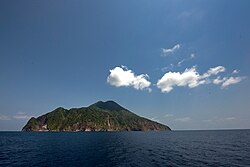 Narcondam island south view
 -
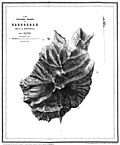 Topography of the island


See also[edit | edit source]

- Exclusive economic zones
- Exclusive economic zone of India
- Exclusive economic zone of Indonesia
- Exclusive economic zone of Malaysia
- Exclusive economic zone of Thailand
- India's Look-East Connectivity projects
- Sabang strategic port development, India-Indonesia project
- Sittwe Port, India-Myanmar project
- Dawei Port Project in Myanmar
- Extreme points
- Indira Point, India's southernmost point of Andaman Nicobar Islands group
- Rondo Island, Indonesia's northernmost island is closest to Indira Point
- Landfall Island, India's northernmost island of Andaman Nicobar Islands group
- Coco Islands, Myanmar's islands in Andaman sea just north of India's Prearis Island
- Extreme points of India
- Extreme points of Indonesia
- Extreme points of Myanmar
- Extreme points of Bangladesh
- Extreme points of Thailand
- Borders of India
- Other topics
- List of volcanoes in India
- List of endangered animals in India
- List of World Heritage Sites in India
References[edit | edit source]
- ↑ "Islandwise Area and Population - 2011 Census" (PDF). Government of Andaman. Archived from the original (PDF) on 28 August 2017. Retrieved 22 September 2016.
- ↑ Sailing Directions (Enroute), Pub. 173: India and the Bay of Bengal (PDF). Sailing Directions. United States National Geospatial-Intelligence Agency. 2017. p. 274.
- ↑ "A&N Islands - Pincodes". 22 September 2016. Archived from the original on 23 March 2014. Retrieved 22 September 2016.
{{cite web}}: CS1 maint: bot: original URL status unknown (link) - ↑ code
- ↑ Registration Plate Numbers added to ISO Code
- ↑ Yahya, H. S. A.; Zarri, A. A. (2002). "Status, ecology and behaviour of Narcondam Hornbill (Aceros narcondami) in Narcondam Island, Andaman and Nicobar Islands, India". J. Bombay Nat. Hist. Soc. 99 (3): 434–445.
- ↑ Washington, H. S. (1 June 1924). "The lavas of Barren Island and Narcondam". American Journal of Science. s5-7 (42): 441–456. Bibcode:1924AmJS....7..441W. doi:10.2475/ajs.s5-7.42.441.
- ↑ "Narcondum". The National Museum of Natural History. Archived from the original on 5 April 2021. Retrieved 21 April 2010.
- ↑ Charney, Jonathan I. & Alexander, Lewis M.; International maritime boundaries, Volumes 2-3; American Society of International Law, Report 6-3, pg. 1329-1336; Martinus Nijhoff Publishers, 1998
- ↑ Book
- ↑ "Government of India, Directorate General of Lighthouses and Lightships". www.dgll.nic.in. Retrieved 18 October 2016.
- ↑ "Village Code Directory: Andaman & Nicobar Islands" (PDF). Census of India. Retrieved 16 January 2011.
- ↑ "Tehsils" (PDF). Archived from the original (PDF) on 28 August 2017. Retrieved 22 September 2016.
- ↑ 14.0 14.1 "District Census Handbook - Andaman & Nicobar Islands" (PDF). 2011 Census of India. Directorate of Census Operations, Andaman & Nicobar Islands. Archived from the original (PDF) on 1 August 2015. Retrieved 21 July 2015.
- ↑ 15.0 15.1 15.2 International), BirdLife International (BirdLife (20 August 2020). "IUCN Red List of Threatened Species: Rhyticeros narcondami". IUCN Red List of Threatened Species. Retrieved 4 May 2021.
- ↑ 16.0 16.1 Raman, T. R. Shankar; Mudappa, Divya; Khan, Tasneem; Mistry, Umeed; Saxena, Ajai; Varma, Kalyan; Ekka, Naveen; Lenin, Janaki; Whitaker, Romulus (2013). "An expedition to Narcondam: observations of marine and terrestrial fauna including the island-endemic hornbill". Current Science. 105 (3): 346–360. ISSN 0011-3891. JSTOR 24097967.
- ↑ Kamalakannan, Manokaran; Sivaperuman, Chandrakasan; Kundu, Shantanu; Gokulakrishnan, Govindarasu; Venkatraman, Chinnadurai; Chandra, Kailash (3 May 2021). "Discovery of a new mammal species (Soricidae: Eulipotyphla) from Narcondam volcanic island, India". Scientific Reports. 11 (1): 9416. Bibcode:2021NatSR..11.9416K. doi:10.1038/s41598-021-88859-4. ISSN 2045-2322. PMC 8093265. PMID 33941819.
- ↑ "Narcondam Island".
- ↑ Shrivastava, Kumar Sambhav (6 September 2012). "MoEF says no to radar installation in Narcondam hornbill habitat". Down To Earth. Centre for Science & Environment, India. Retrieved 31 May 2013.
{{cite web}}: CS1 maint: deprecated archival service (link) - ↑ "Green nod for radar station at Narcondam in Andamans". The Economic Times.
External links[edit | edit source]
- Pages using the JsonConfig extension
- Islands of North and Middle Andaman district
- Tourist attractions in the Andaman and Nicobar Islands
- Cities and towns in North and Middle Andaman district
- Volcanoes of India
- Volcanoes of the Indian Ocean
- Active volcanoes
- Important Bird Areas of the Andaman and Nicobar Islands
- Populated places in India
- Islands of India
- Islands of the Bay of Bengal
- World Heritage Tentative List for India