


No edit summary |
formatting fix |
||
| Line 1: | Line 1: | ||
{{Use dmy dates|date=August 2018}} | {{Use dmy dates|date=August 2018}} | ||
{{Use Indian English|date=August 2018}} | {{Use Indian English|date=August 2018}} | ||
{{copy edit|date=February 2026}} | |||
{{Infobox settlement | {{Infobox settlement | ||
| name | | name = Jayankondam | ||
| other_name = | |||
| nickname = Cashew City | |||
| other_name | | settlement_type = First Grade Municipality | ||
| nickname | | image_skyline = GangaiKonda Cholapuram(Front View).JPG | ||
| settlement_type | | image_alt = | ||
| image_skyline | | image_caption = | ||
| image_alt | | pushpin_map = India Tamil Nadu | ||
| image_caption | | pushpin_label_position = left | ||
| pushpin_map | | pushpin_map_alt = | ||
| pushpin_label_position | | pushpin_map_caption = Location in Tamil Nadu, India | ||
| pushpin_map_alt | | coordinates = {{coord|11.212|N|79.365|E|display=inline,title}} | ||
| pushpin_map_caption | | subdivision_type = Country | ||
| coordinates | | subdivision_name = {{flag|India}} | ||
| subdivision_type | | subdivision_type1 = [[States and territories of India|State]] | ||
| subdivision_name | | subdivision_name1 = [[Tamil Nadu]] | ||
| subdivision_type1 | | subdivision_type2 = [[List of districts of India|District]] | ||
| subdivision_name1 | | subdivision_name2 = Ariyalur | ||
| subdivision_type2 | | established_title = <!-- Established --> | ||
| subdivision_name2 | | established_date = | ||
| established_title | | founder = | ||
| established_date | | named_for = | ||
| founder | | government_type = Municipality | ||
| named_for | | governing_body = Jayankondan Municipality | ||
| government_type | | unit_pref = Metric | ||
| governing_body | | area_footnotes = | ||
| unit_pref | | area_rank = | ||
| area_footnotes | | area_total_km2 = | ||
| area_rank | | elevation_footnotes = | ||
| area_total_km2 | | elevation_m = | ||
| elevation_footnotes | | population_total = 46,000 | ||
| elevation_m | | population_as_of = 2023 | ||
| population_total | | population_rank = | ||
| population_as_of | | population_density_km2 = auto | ||
| population_rank | | population_demonym = | ||
| population_density_km2 | | population_footnotes = | ||
| population_demonym | | demographics_type1 = Languages | ||
| population_footnotes | | demographics1_title1 = Official | ||
| demographics_type1 | | demographics1_info1 = [[Tamil language|Tamil]] | ||
| demographics1_title1 | | timezone1 = [[Indian Standard Time|IST]] | ||
| demographics1_info1 | | utc_offset1 = +5:30 | ||
| timezone1 | | postal_code_type = [[Postal Index Number|PIN]] | ||
| utc_offset1 | | postal_code = 621802 | ||
| postal_code_type | | area_code_type = Telephone code | ||
| postal_code | | area_code = 04331 | ||
| area_code_type | | registration_plate = TN 61 | ||
| area_code | | website = https://jayankondam.in | ||
| registration_plate | | footnotes = | ||
| website | |||
| footnotes | |||
}} | }} | ||
'''Jayankondam''' is a | '''Jayankondam''' is a First Grade | ||
Municipality in [[Ariyalur district]] of Tamil Nadu in India. As of 2023, the town had a population of 46,000. | |||
Huge amounts of lignite deposits have been found here and power projects have been initiated by the [[Neyveli Lignite Corporation]].<ref>{{cite web| url = http://newindianexpress.com/states/tamil_nadu/article529907.ece| title = Jayankondam Lignite Mine viable: CMD- The New Indian Express}} </ref> This town has more than 25 temples of various historical periods in the vicinity. The existing Government Higher Secondary School at Jayankondam is as the old as the town and has nearly 2000 | Huge amounts of lignite deposits have been found here and power projects have been initiated by the [[Neyveli Lignite Corporation]].<ref>{{cite web| url = http://newindianexpress.com/states/tamil_nadu/article529907.ece| archive-url = https://web.archive.org/web/20130518121707/http://newindianexpress.com/states/tamil_nadu/article529907.ece| url-status = dead| archive-date = 18 May 2013| title = Jayankondam Lignite Mine viable: CMD- The New Indian Express}} </ref> | ||
This town has more than 25 temples of various historical periods in the vicinity. | |||
The existing Government Higher Secondary School at Jayankondam is as the old as the town and has nearly 2000 students enrolled. | |||
==Location== | ==Location== | ||
Jayankondam is | Jayankondam is well-connected with roadways. The national highway NH-81 passes through this town, connects [[Chidambaram]] and [[Tiruchirapalli]]. The state highway SH-140 which connects [[Virudhachalam|Virudachalam]] with [[Kumbakonam]] passes through this town. [[Chennai]] is located 247 km. Kumbakonam is to the south, around 29 km from Jayankondam via the Neelathanallur-Mathanathur bridge. [[Ariyalur]] is 38 km to the west. [[Virudhachalam|Viruthachalam]] is 36 km to the north and [[Chidambaram]] is 50 km to the east. | ||
Jayankondam Town limit extends over an area of 28 km<sup>2</sup>. | Jayankondam Town limit extends over an area of 28 km<sup>2</sup>. | ||
| Line 68: | Line 72: | ||
==History== | ==History== | ||
Jayankondacholapuram is full name of Jayankondam. Original name is Nellimanagramam. King Rajendracholan (ராஜேந்திரசோழன்) | Jayankondacholapuram is full name of Jayankondam. Original name is Nellimanagramam. The place was renamed as Jayankondacholapuram (ஜெயங்கொண்டசோழபுரம்) during the period of King Rajendracholan (ராஜேந்திரசோழன்) as they (Rajendra and his son) were victorious in many wars and campaigns. Jayankondam was established as town panchayat during [[British Raj|British rule]]. Jayankondam was upgraded as second municipality of Perambalur district after Perambalur. | ||
==Administration and politics== | ==Administration and politics== | ||
| Line 74: | Line 78: | ||
==Transportation== | ==Transportation== | ||
[[National Highway 81 (India)|NH81]] - Trichy - Jayankondam - Chidambaram, SH140 - Kumbakonam - Jayankondam - Virudhachalam, NH36 - Kumbakonam - Vikravandi, SH139 Jayankondam - Ariyalur, are major roads via Jayankondam. Jayankondam busstand is located in centre of town. TNSTC Jayankondam branch is under Trichy region of Kumbakonam Corporation. Government, Private buses operated to nearby towns Kumbakonam, Mayiladudurai, Virudhachalam, Trichy, Chidambaram, Cuddalore, Puducherry, Neyveli, Thanjavur, Ariyalur, Perambalur, Thuraiyur, Salem | [[National Highway 81 (India)|NH81]] - Trichy - Jayankondam - Chidambaram, SH140 - Kumbakonam - Jayankondam - Virudhachalam, NH36 - Kumbakonam - Vikravandi, SH139 Jayankondam - Ariyalur, are major roads via Jayankondam. Jayankondam busstand is located in centre of town. TNSTC Jayankondam branch is under Trichy region of Kumbakonam Corporation. Government, Private buses operated to nearby towns Kumbakonam, Mayiladudurai, Virudhachalam, Trichy, Chidambaram, Cuddalore, Puducherry, Neyveli, Thanjavur, Ariyalur, Perambalur, Thuraiyur, Attur, Salem, Chennai, Coimbatore, Tiruppur, Palani, Madurai, Hosur, and Banglore from Jayankondam busstand. | ||
The nearest railway stations are Virudhachalam Junction railway station, 40 km away, Ariyalur Railway station, 38 km away, and Kumbakonam Railway station, 30 km away. | |||
The nearest airport is [[Tiruchirappalli International Airport]], 98 km away. | |||
The nearest seaport is [[Karaikal port]]. | |||
==Places near Jayankondam== | ==Places near Jayankondam== | ||
[[Gangaikonda Cholapuram]] capital of the [[Chola dynasty]] in c. 1025 during the reign of [[Rajendra Chola I]], and served as the [[Chola]] capital for around 250 years. The village is | [[Gangaikonda Cholapuram]] was the capital of the [[Chola dynasty]] in c. 1025 during the reign of [[Rajendra Chola I]], and served as the [[Chola]] capital for around 250 years. The village is 8 km from Jayankondam. The city was founded by [[Rajendra Chola I]] to commemorate his victory over the Pala Dynasty. The name means The town of the chola who took over Ganga (water from Ganga) or who defeated (the kings near) Ganga. It is now a small village, its past eminence only remembered by the existence of the great [[Brihadisvara Temple, Gangaikonda Cholapuram|Brihadisvara Temple]]. The temple has been recognised as a [[World Heritage Site|World Heritage site]] by [[UNESCO]] [[Chola dynasty|Chola empire]] included the whole of southern India to the river Thungabadhra in the north.<ref>{{Cite web|date=2018-10-11|title=Gangaikondacholapuram Brihadeeswarar temple - Possibly the most elegant UNESCO Heritage Site|url=https://polkajunction.com/gangaikondacholapuram-temple-most-elegant-unesco-heritage-site-in-the-world-tamilnadu-india-rajendrachola/|access-date=2021-01-09|website=PolkaJunction|language=en-GB}}</ref> For administrative and strategic purposes they built another capital and named it Gangaikondacholapuram. | ||
[[Anaikarai]] is 15 km from Jayankondam. The Lower Anaicut built by [[Arthur Cotton|Sir Arthur Cotton]] in 19th century AD across [[Kollidam River|Coleroon]], the major distributary of [[Kaveri|Cauvery]], is said to be a replicated structure of [[Kallanai Dam|Kallanai]]. | [[File:Buddha statute jkm.jpg|alt=Buddha statue at Jayankondam, maintained by Archeological department|thumb|311x311px|Buddha statue at Jayankondam, maintained by the Archeological Department of India]] | ||
[[Anaikarai]] is 15 km from Jayankondam. The Lower Anaicut was built by [[Arthur Cotton|Sir Arthur Cotton]] in 19th century AD across [[Kollidam River|Coleroon]], the major distributary of [[Kaveri|Cauvery]], is said to be a replicated structure of [[Kallanai Dam|Kallanai]]. Nearly 2000 families live in Anaikarai with the main occupation of agriculture and fishing. It is well known and place for river fishes | |||
PIN (Postal Index) Code for Jayankondam is 621802. Also the following nearby post offices share the same pin [[Angarayanallur (East)|Angarayanallur]], Chinnavalayam, Kaluvanthondi, Karadikulam, Kilakudiyiruppu, [[Periyavalayam]] and [[Sengunthapuram]].<ref>{{cite web|title=List of Post Offices for Pin Code 621802|url=http://pincode.net.in/621802|work=Pin code|access-date=22 August 2011}}</ref> | PIN (Postal Index) Code for Jayankondam is 621802. Also the following nearby post offices share the same pin [[Angarayanallur (East)|Angarayanallur]], Chinnavalayam, Kaluvanthondi, Karadikulam, Kilakudiyiruppu, [[Periyavalayam]] and [[Sengunthapuram]].<ref>{{cite web|title=List of Post Offices for Pin Code 621802|url=http://pincode.net.in/621802|work=Pin code|access-date=22 August 2011}}</ref> | ||
The Historical Shiva temple in Jayankondam was built by wife of Rajendra cholan (queen) for her personal worship during the king's victory celebration over Pala dynasty. | |||
Cholas also esteemed Buddhism and built several Buddha temples, they are now in Srilanka. Archeological department of India found a buddha statue in Jayankondam and maintains it till date. | |||
[[File:Busy Noon Day in Bus Stand Road, Jayankondam.jpg|thumb|Bus Stand Road-2008]] | [[File:Busy Noon Day in Bus Stand Road, Jayankondam.jpg|thumb|Bus Stand Road-2008]] | ||
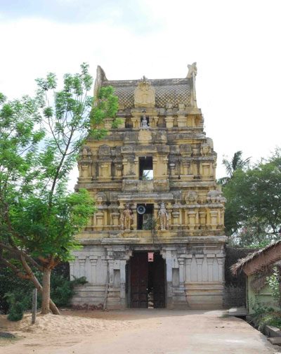
[[File:Jkmsivatemple.jpg|thumbnail|Historical Siva temple]] | [[File:Jkmsivatemple.jpg|thumbnail|Historical Siva temple]] | ||
| Line 92: | Line 108: | ||
* [http://jkmonline.com/ JKMOnline.com - Information about Jayankondam] | * [http://jkmonline.com/ JKMOnline.com - Information about Jayankondam] | ||
* [https://www.jayankondacholapuram.com Jayankondam Town information] | * [https://www.jayankondacholapuram.com Jayankondam Town information] | ||
* [http://www.jkmworld.com/ Jayankondam | * [http://www.jkmworld.com/ Jayankondam people around the world community site] | ||
* [http://Gangaikondacholapuram.com - Gangaikondacholapuram - Bragatheeswarar Temple | * [http://Gangaikondacholapuram.com - Gangaikondacholapuram - Bragatheeswarar Temple] | ||
* [http://www.facebook.com/jayankondam.tamilnadu/ Jayankondam Facebook page] | * [http://www.facebook.com/jayankondam.tamilnadu/ Jayankondam Facebook page] | ||
Latest revision as of 09:22, 24 February 2026
 | This article may require copy editing for grammar, style, cohesion, tone, or spelling. (February 2026) |
Jayankondam | |
|---|---|
First Grade Municipality | |
.JPG) | |
| Nickname: Cashew City | |
  Jayankondam Location in Tamil Nadu, India | |
| Coordinates: 11°12′43″N 79°21′54″E / 11.212°N 79.365°E | |
| Country |  India India |
| State | Tamil Nadu |
| District | Ariyalur |
| Government | |
| • Type | Municipality |
| • Body | Jayankondan Municipality |
| Population (2023) | |
| • Total | 46,000 |
| Languages | |
| • Official | Tamil |
| Time zone | UTC+5:30 (IST) |
| PIN | 621802 |
| Telephone code | 04331 |
| Vehicle registration | TN 61 |
| Website | https://jayankondam.in |
Jayankondam is a First Grade Municipality in Ariyalur district of Tamil Nadu in India. As of 2023, the town had a population of 46,000.
Huge amounts of lignite deposits have been found here and power projects have been initiated by the Neyveli Lignite Corporation.[1]
This town has more than 25 temples of various historical periods in the vicinity.
The existing Government Higher Secondary School at Jayankondam is as the old as the town and has nearly 2000 students enrolled.
Location[edit | edit source]
Jayankondam is well-connected with roadways. The national highway NH-81 passes through this town, connects Chidambaram and Tiruchirapalli. The state highway SH-140 which connects Virudachalam with Kumbakonam passes through this town. Chennai is located 247 km. Kumbakonam is to the south, around 29 km from Jayankondam via the Neelathanallur-Mathanathur bridge. Ariyalur is 38 km to the west. Viruthachalam is 36 km to the north and Chidambaram is 50 km to the east.
Jayankondam Town limit extends over an area of 28 km2.
Demographics[edit | edit source]
According to 2011 census, Jayankondam had a population of 33,945 with a sex-ratio of 1,031 females for every 1,000 males, much above the national average of 929.[2] A total of 3,520 were under the age of six, constituting 1,866 males and 1,654 females. Scheduled Castes and Scheduled Tribes accounted for 17.88% and 2.06% of the population respectively. The average literacy of the town was 72.%, compared to the national average of 72.99%.[2] The town had a total of : 8664 households. There were a total of 12,359 workers, comprising 611 cultivators, 1,386 main agricultural labourers, 1,004 in house hold industries, 7,592 other workers, 1,766 marginal workers, 87 marginal cultivators, 736 marginal agricultural labourers, 329 marginal workers in household industries and 614 other marginal workers.[3] As per the religious census of 2011, Jayankondam (M) had 92.63% Hindus, 4.53% Muslims, 2.42% Christians, 0.06% Sikhs, 0.01% Buddhists, 0.01% Jains, 0.31% following other religions and 0.03% following no religion or did not indicate any religious preference.[4]
History[edit | edit source]
Jayankondacholapuram is full name of Jayankondam. Original name is Nellimanagramam. The place was renamed as Jayankondacholapuram (ஜெயங்கொண்டசோழபுரம்) during the period of King Rajendracholan (ராஜேந்திரசோழன்) as they (Rajendra and his son) were victorious in many wars and campaigns. Jayankondam was established as town panchayat during British rule. Jayankondam was upgraded as second municipality of Perambalur district after Perambalur.
Administration and politics[edit | edit source]
Jayankondam is second grade municipality. Jayankondam comes under the Jayankondam State Assembly Constituency and it elect a member to the Tamil Nadu Legislative Assembly once every five years. Before 2009 Jayankondam came under Perambalur Lok sabha constituency. After 2009 Jayankondam comes under Chidambaram Lok sabha constituency.
Transportation[edit | edit source]
NH81 - Trichy - Jayankondam - Chidambaram, SH140 - Kumbakonam - Jayankondam - Virudhachalam, NH36 - Kumbakonam - Vikravandi, SH139 Jayankondam - Ariyalur, are major roads via Jayankondam. Jayankondam busstand is located in centre of town. TNSTC Jayankondam branch is under Trichy region of Kumbakonam Corporation. Government, Private buses operated to nearby towns Kumbakonam, Mayiladudurai, Virudhachalam, Trichy, Chidambaram, Cuddalore, Puducherry, Neyveli, Thanjavur, Ariyalur, Perambalur, Thuraiyur, Attur, Salem, Chennai, Coimbatore, Tiruppur, Palani, Madurai, Hosur, and Banglore from Jayankondam busstand.
The nearest railway stations are Virudhachalam Junction railway station, 40 km away, Ariyalur Railway station, 38 km away, and Kumbakonam Railway station, 30 km away.
The nearest airport is Tiruchirappalli International Airport, 98 km away.
The nearest seaport is Karaikal port.
Places near Jayankondam[edit | edit source]
Gangaikonda Cholapuram was the capital of the Chola dynasty in c. 1025 during the reign of Rajendra Chola I, and served as the Chola capital for around 250 years. The village is 8 km from Jayankondam. The city was founded by Rajendra Chola I to commemorate his victory over the Pala Dynasty. The name means The town of the chola who took over Ganga (water from Ganga) or who defeated (the kings near) Ganga. It is now a small village, its past eminence only remembered by the existence of the great Brihadisvara Temple. The temple has been recognised as a World Heritage site by UNESCO Chola empire included the whole of southern India to the river Thungabadhra in the north.[5] For administrative and strategic purposes they built another capital and named it Gangaikondacholapuram.

Anaikarai is 15 km from Jayankondam. The Lower Anaicut was built by Sir Arthur Cotton in 19th century AD across Coleroon, the major distributary of Cauvery, is said to be a replicated structure of Kallanai. Nearly 2000 families live in Anaikarai with the main occupation of agriculture and fishing. It is well known and place for river fishes
PIN (Postal Index) Code for Jayankondam is 621802. Also the following nearby post offices share the same pin Angarayanallur, Chinnavalayam, Kaluvanthondi, Karadikulam, Kilakudiyiruppu, Periyavalayam and Sengunthapuram.[6]
The Historical Shiva temple in Jayankondam was built by wife of Rajendra cholan (queen) for her personal worship during the king's victory celebration over Pala dynasty.
Cholas also esteemed Buddhism and built several Buddha temples, they are now in Srilanka. Archeological department of India found a buddha statue in Jayankondam and maintains it till date.


References[edit | edit source]
- ↑ "Jayankondam Lignite Mine viable: CMD- The New Indian Express". Archived from the original on 18 May 2013.
- ↑ 2.0 2.1 "Census Info 2011 Final population totals". Office of The Registrar General and Census Commissioner, Ministry of Home Affairs, Government of India. 2013. Retrieved 26 January 2014.
- ↑ "Census Info 2011 Final population totals - Jayankondam". Office of The Registrar General and Census Commissioner, Ministry of Home Affairs, Government of India. 2013. Retrieved 26 January 2014.
- ↑ "Population By Religious Community - Tamil Nadu" (XLS). Office of The Registrar General and Census Commissioner, Ministry of Home Affairs, Government of India. 2011. Retrieved 13 September 2015.
- ↑ "Gangaikondacholapuram Brihadeeswarar temple - Possibly the most elegant UNESCO Heritage Site". PolkaJunction. 11 October 2018. Retrieved 9 January 2021.
- ↑ "List of Post Offices for Pin Code 621802". Pin code. Retrieved 22 August 2011.