Manapparai
Manapparai (Tamil: [manappaːɾaɪ]) is a town and a municipality in Tiruchirappalli district in the Indian state of Tamil Nadu. Manapparai Town is Located at 38 km Away From Trichy Headquarters, Manapparai is the headquarters of the Manapparai Taluk. Manapparai is famous for murukku (deep-fried snacks) and cattle market. As of 2011, the town had a population of 40,510.
Manapparai / Manaparai | |
|---|---|
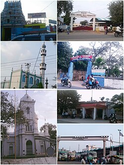
 Clockwise from Top left : Arulmigu Mariyamman Temple, Government District Headquarters Hospital, Model Police Station, Manaparai Railway Station, Municipal Bus Stand, Our lady of Lourdes Church, Big Mosque | |
| Nickname: Manavai | |
| Coordinates: 10°36′27″N 78°24′54″E / 10.60759°N 78.414874°ECoordinates: 10°36′27″N 78°24′54″E / 10.60759°N 78.414874°E | |
| Country | |
| State | Tamil Nadu |
| District | Tiruchirappalli |
| Region | Chola Nadu |
| Named for | Murukku, Cattle market |
| Government | |
| • Type | First Grade Municipality |
| • Body | Manapparai Municipality |
| • Chairman | Vacant |
| Area | |
| • Total | 20.85 km2 (8.05 sq mi) |
| • Rank | A Grade |
| Elevation | 172 m (564 ft) |
| Population (2011) | |
| • Total | 40,510 |
| • Density | 1,900/km2 (5,000/sq mi) |
| Languages | |
| • Official | Tamil |
| Time zone | UTC+5:30 (IST) |
| PIN | 621306 |
| Telephone code | 914332 |
| Vehicle registration | TN 45Z **** |
| Website | www |
DemographicsEdit
According to the 2011 census, Manapparai had a population of 370,482 with a sex-ratio of 1,012 females for every 1,000 males, much above the national average of 929.[1] A total of 4,090 people were under the age of six, constituting 2,096 males and 1,994 females. Scheduled Castes and Scheduled Tribes accounted for 11.97% and 0.18% of the population respectively. The average literacy of the town was 78.98%, compared to the national average of 72.99%.[1] The town had a total of 9,934 households. There were a total of 14,930 workers, comprising 455 cultivators, 749 main agricultural labourers, 582 in house hold industries, 11,518 other workers, 1,626 marginal workers, 29 marginal cultivators, 470 marginal agricultural labourers, 51 marginal workers in household industries and 1,076 other marginal workers.[2] As per the religious census of 2011, Manapparai (M) had 65.67% Hindus, 11.3% Muslims, 22.95% Christians, 0.01% Sikhs, 0.01% Buddhists, 0.0% Jains, 0.06% following other religions and 0.0% following no religion or did not indicate any religious preference.[3]
PoliticsEdit
Manaparai is the headquarters of Manaparai Legislative Assembly Constituency, which is part of the Karur Loksabha Constituency. Abdul Samad is the present Member of legislative assembly(MLA) representing Manaparai Constituency and Ms. Jothimani Sennimalai is the present Member of Parliament(MP) representing Karur constituency
Notable FestivalsEdit
Every year in the Tamil month of Chithirai, The Chithirai festival of Arulmigu Veppilai Marriamman Temple is celebrated over a month long period. Approximately, several Thousands of devotees from various parts of south India attends the festival.
TransportEdit
Manapparai lies between Trichy and Dindigul in NH 45 (NH 83) . The town is connected with Musiri and Pudukkottai with SH 71. Also, There are also main roads which connect Manappari with Thuvarankurichi ( Via Thuvarankurichy , we can reach Madurai ), and Kovilpatty.[4]
Bus TransportationEdit
About 300 buses pass through the municipal bus stand, which is a ‘C’–Class and constructed in 1981. The bus stand was renewed and expanded in the year 2017.
Manapparai is connected with Trichy, DIndigul, Palani, Theni, Kambam , Kumily with frequent bus services. Manapparai is also connected with the following towns by bus facilities
Rail TransportationEdit
Manapparai Railway station ( Station code : MPA ) is situated on Trichy - Dindigul Double electric broad gauge line.
Adjacent communitiesEdit
This section needs expansion. You can help by adding to it. (September 2021) |
See alsoEdit
ReferencesEdit
- ↑ 1.0 1.1 "Census Info 2011 Final population totals". Office of The Registrar General and Census Commissioner, Ministry of Home Affairs, Government of India. 2013. Archived from the original on 13 November 2013. Retrieved 26 January 2014.
- ↑ "Census Info 2011 Final population totals - Manapparai(05781)". Office of The Registrar General and Census Commissioner, Ministry of Home Affairs, Government of India. 2013. Archived from the original on 24 September 2015. Retrieved 26 January 2014.
- ↑ "Population By Religious Community - Tamil Nadu" (XLS). Office of The Registrar General and Census Commissioner, Ministry of Home Affairs, Government of India. 2011. Retrieved 13 September 2015.
- ↑ "Kovilpatti". Kovilpatti. Retrieved 15 February 2021.

