


Minor edit Tags: Visual edit Mobile edit Mobile web edit |
brief expand section per standard format additionally and improved wording |
||
| Line 1: | Line 1: | ||
{{Short description|Town in Bihar}} | {{Short description|Town in Bihar}} | ||
{{Use dmy dates|date=April 2018}} | {{Use dmy dates|date=April 2018}} | ||
{{Use Indian English|date=April 2018}} | {{Use Indian English|date=April 2018}} | ||
{{Infobox settlement | {{Infobox settlement | ||
| name | | name = Sursand | ||
| other_name = | |||
| nickname = | |||
| other_name | | settlement_type = Town | ||
| nickname | | image_skyline = Sursand temple 3.jpg | ||
| settlement_type | | image_size = 320px | ||
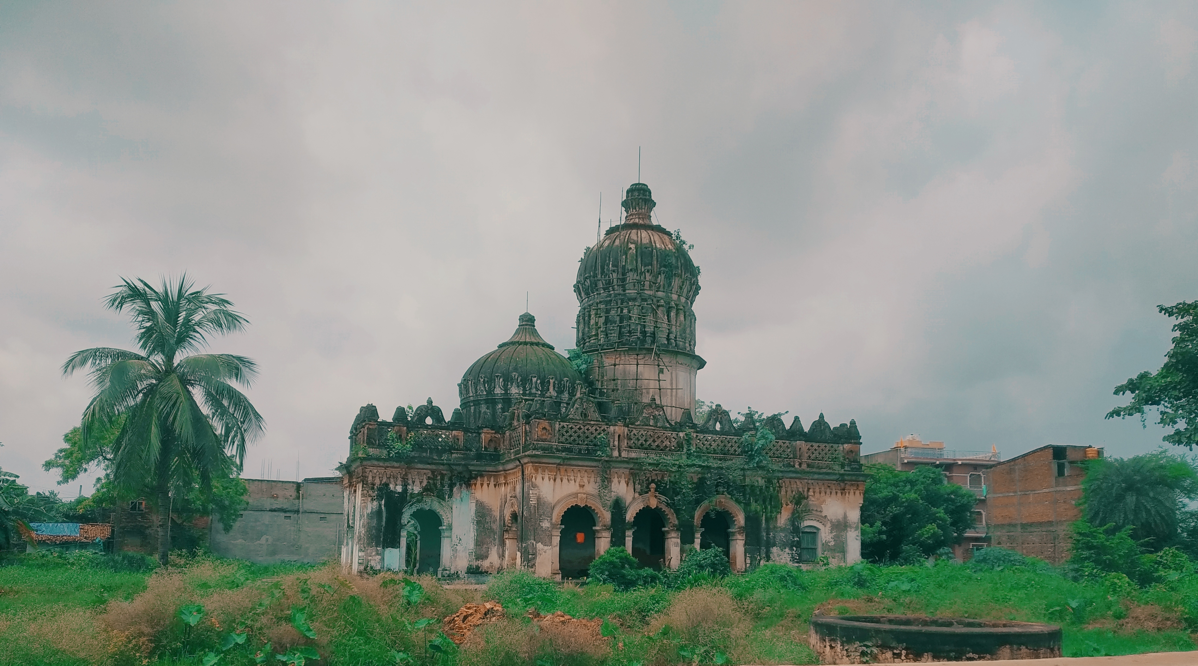
| image_skyline | | image_caption = An ancient temple locally known as [[Choraut Mandir, Sursand|Choraut Mandir]] in Sursand | ||
| | | pushpin_map = India Bihar | ||
| image_caption | | pushpin_label_position = right | ||
| pushpin_map | | pushpin_map_alt = | ||
| pushpin_label_position | | pushpin_map_caption = Location in Bihar, India | ||
| pushpin_map_alt | | coordinates = {{coord|26|39|0|N|85|43|0|E|display=inline,title}} | ||
| pushpin_map_caption | | subdivision_type = Country | ||
| coordinates | | subdivision_name = {{flag|India}} | ||
| subdivision_type | | subdivision_type1 = [[States and territories of India|State]] | ||
| subdivision_name | | subdivision_name1 = [[Bihar]] | ||
| subdivision_type1 | | subdivision_type2 = [[List of regions of India|Region]] | ||
| subdivision_name1 | | subdivision_name2 = [[Mithila (region)|Mithila]] | ||
| subdivision_type2 | | subdivision_type3 = [[List of districts of India|District]] | ||
| | | subdivision_name3 = [[Sitamarhi district|Sitamarhi]] | ||
| established_title | | established_title = <!-- Established --> | ||
| established_date | | established_date = | ||
| founder | | founder = | ||
| named_for | | named_for = | ||
| government_type | | government_type = [[Nagar Panchayat]] | ||
| governing_body | | governing_body = | ||
| unit_pref | | unit_pref = Metric | ||
| area_footnotes | | area_footnotes = | ||
| area_rank | | area_rank = | ||
| area_total_km2 | | area_total_km2 = | ||
| elevation_m | | elevation_m = 55 | ||
| elevation_footnotes | | elevation_footnotes = <ref>{{Cite web |title=Maps, Weather, and Airports for Sursand, India |url=https://www.fallingrain.com/world/IN/34/Sursand.html |access-date=16 August 2021 | website=Falling Rain}}</ref> | ||
| population_total | | population_total = 29688 | ||
| population_as_of | | population_as_of = 2011 | ||
| population_rank | | population_rank = | ||
| population_density_km2 | | population_density_km2 = auto | ||
| population_demonym | | population_demonym = | ||
| population_footnotes | | population_footnotes = | ||
| demographics_type1 | | demographics_type1 = Languages | ||
| demographics1_title1 | | demographics1_title1 = Official | ||
| demographics1_info1 | | demographics1_info1 = [[Maithili language|Maithili]], [[Hindi language|Hindi]] | ||
| timezone1 | | timezone1 = [[Indian Standard Time|IST]] | ||
| utc_offset1 | | utc_offset1 = +5:30 | ||
| postal_code_type | | postal_code_type = <!-- [[Postal Index Number|PIN]] --> | ||
| postal_code | | postal_code = 843331 | ||
| registration_plate | | registration_plate = BR-30 | ||
| blank1_name_sec1 | | blank1_name_sec1 = Coastline | ||
| blank1_info_sec1 | | blank1_info_sec1 = {{Convert|0|km|mi}} | ||
| website | | website = | ||
| footnotes | | footnotes = | ||
| official_name | | official_name = | ||
| demographics_type2 | | demographics_type2 = | ||
| | }}{{Related|[[Valmikeshwar Nath Mahadev Mandir]]|[[Swarna Rani Mandir, Sursand]]|[[Mithilapuri Jain Teerth]]}} | ||
| | '''Sursand''' is an Indian town in the [[Mithila (region)|Mithila]] region of [[Bihar]] near the Indo-Nepal border. It was previously the capital of the [[Sursand Raj]] in the region. It is about 25 Km to the east of [[Sitamarhi]], the district headquarters, and approximately 5 Km to the west of [[Bhitthamore]].<ref>{{Cite web|title=Sursand News, Sursand की ताज़ा ख़बर, Sursand हिंदी न्यूज़ page1|url=https://www.livehindustan.com/tags/sursand|access-date=2021-02-04|website=Hindustan|language=hi}}</ref> | ||
| | |||
}} | |||
'''Sursand''' is an | |||
==History== | ==History== | ||
The village has the ruins of a fortress | The village has the ruins of a fortress known as Sursandgarh, which was constructed during the [[Mughal Empire|Mughal]] period by King Sursen.<ref>{{cite book | url=https://books.google.com/books?id=TEdpwKpTYqsC&q=sursandgarh | page=147 | title=Systems of rural settlements in developing countries | first=R. B. | last=Mandal | year=1989 | publisher=Concept Publishing | isbn=9788170222033 | accessdate=26 April 2018 }}</ref> | ||
According to an account published in the Bengal District Gazetteers, | According to an account published in the ''Bengal District Gazetteers'', | ||
<blockquote> | <blockquote> | ||
The name of the place is said to be derived from Sur Sen, a chieftain who once lived there. After his death, it lapsed once more into jungle, until it was reclaimed by two brothers—Mahesh Jha and Amar Jha, the founders of the present Sursand family. These brothers, the story runs, left their home at Ghograha, in the district of Darbhanga, and came to settle at Jadupati, a village belonging to them, 8 miles from Sursand. One day Mahesh Jha went with his astrologer to hunt in the woods at Sursand, and came across the ruins of Sur Sen's fort. The astrologer having told him that the man who made a home there would be a Raja, Mahesh Jha acted on his advice and cleared the jungle. The several branches of the Sursand family sprang from his son, Chaudhri Kelwal Krishna. Amar Jha's branch did not prosper, and his descendants are impoverished. Chaudhri Hirdai Narayan, a descendant of the elder branch, added largely to the family estates.<ref>{{cite book|title=Bengal District Gazetteers|volume=34|issue=1|page=159|year=1907|publisher=The Bengal Secretariat Book Depôt|url=https://books.google.com/books?id=LRMmAQAAIAAJ&q=sursand+nepal}}</ref> | |||
</blockquote> | </blockquote> | ||
== | ==Gallery== | ||
[[File:Sursand sitamarhi.jpg|thumb|Famous pond in Sursand]] | |||
[[File:Sursand Palace in Ruins.png|thumb|Sursand Palace in ruins]] | |||
[[File:Sursand temple 2.jpg|thumb|A Hindu temple in Sursand]] | |||
==Archaeological geography== | ==Archaeological geography== | ||
In the outskirts of the modern town, the area locally known as Garh Devi Sthan has a three-metre high circular mound covering about two acres of ground.<ref>{{cite book|title=Archaeological Geography of the Ganga Plain: The Lower and the Middle Ganga|page=200|year=2001|publisher= Orient Blackswan|url= https://books.google.com/books?id=OEZe-wAIiKIC&q=SURSAND&pg=PA200|isbn=9788178240169}}</ref> | |||
==Notable people == | |||
== | Shyam Nandan Prasad Mishra served as the Union Deputy Minister for Planning from 1954 to 1962. | ||
== Schools and College == | |||
== | [[Jawahar Lal Neharu Memorial College Nawahi, Sitamarhi|Jawahar Lal Neharu Memorial College, Nawahi, Sitamarhi]] | ||
* | |||
* | |||
* | |||
==References== | ==References== | ||
{{reflist}} | {{reflist}} | ||
==External links== | ==External links== | ||
*[http://www.india9.com/i9show/Sursand-67102.htm About Sursand] | *[http://www.india9.com/i9show/Sursand-67102.htm About Sursand] | ||
*[http://www.maplandia.com/india/bihar/sitamarhi/sursand/ Satellite map of Sursand] | *[http://www.maplandia.com/india/bihar/sitamarhi/sursand/ Satellite map of Sursand] | ||
*[https://books.google.com/books?id=LRMmAQAAIAAJ& | *[https://books.google.com/books?id=LRMmAQAAIAAJ&q=sursand+nepal Bengal district gazetteers 1901] | ||
[[Category:Cities and towns in Sitamarhi district]] | [[Category:Cities and towns in Sitamarhi district]] | ||
[[Category:Transit and customs posts along the India–Nepal border]] | [[Category:Transit and customs posts along the India–Nepal border]] | ||
Latest revision as of 09:01, 16 March 2026
Sursand | |
|---|---|
Town | |
 An ancient temple locally known as Choraut Mandir in Sursand | |
  Sursand Location in Bihar, India | |
| Coordinates: 26°39′0″N 85°43′0″E / 26.65000°N 85.71667°E | |
| Country |  India India |
| State | Bihar |
| Region | Mithila |
| District | Sitamarhi |
| Government | |
| • Type | Nagar Panchayat |
| Elevation | 55 m (180 ft) |
| Population (2011) | |
| • Total | 29,688 |
| Languages | |
| • Official | Maithili, Hindi |
| Time zone | UTC+5:30 (IST) |
| Vehicle registration | BR-30 |
| Coastline | 0 kilometres (0 mi) |
Sursand is an Indian town in the Mithila region of Bihar near the Indo-Nepal border. It was previously the capital of the Sursand Raj in the region. It is about 25 Km to the east of Sitamarhi, the district headquarters, and approximately 5 Km to the west of Bhitthamore.[2]
History[edit | edit source]
The village has the ruins of a fortress known as Sursandgarh, which was constructed during the Mughal period by King Sursen.[3]
According to an account published in the Bengal District Gazetteers,
The name of the place is said to be derived from Sur Sen, a chieftain who once lived there. After his death, it lapsed once more into jungle, until it was reclaimed by two brothers—Mahesh Jha and Amar Jha, the founders of the present Sursand family. These brothers, the story runs, left their home at Ghograha, in the district of Darbhanga, and came to settle at Jadupati, a village belonging to them, 8 miles from Sursand. One day Mahesh Jha went with his astrologer to hunt in the woods at Sursand, and came across the ruins of Sur Sen's fort. The astrologer having told him that the man who made a home there would be a Raja, Mahesh Jha acted on his advice and cleared the jungle. The several branches of the Sursand family sprang from his son, Chaudhri Kelwal Krishna. Amar Jha's branch did not prosper, and his descendants are impoverished. Chaudhri Hirdai Narayan, a descendant of the elder branch, added largely to the family estates.[4]
Gallery[edit | edit source]


Archaeological geography[edit | edit source]
In the outskirts of the modern town, the area locally known as Garh Devi Sthan has a three-metre high circular mound covering about two acres of ground.[5]
Notable people[edit | edit source]
Shyam Nandan Prasad Mishra served as the Union Deputy Minister for Planning from 1954 to 1962.
Schools and College[edit | edit source]
Jawahar Lal Neharu Memorial College, Nawahi, Sitamarhi
References[edit | edit source]
- ↑ "Maps, Weather, and Airports for Sursand, India". Falling Rain. Retrieved 16 August 2021.
- ↑ "Sursand News, Sursand की ताज़ा ख़बर, Sursand हिंदी न्यूज़ page1". Hindustan (in हिन्दी). Retrieved 4 February 2021.
- ↑ Mandal, R. B. (1989). Systems of rural settlements in developing countries. Concept Publishing. p. 147. ISBN 9788170222033. Retrieved 26 April 2018.
- ↑ Bengal District Gazetteers. Vol. 34. The Bengal Secretariat Book Depôt. 1907. p. 159.
- ↑ Archaeological Geography of the Ganga Plain: The Lower and the Middle Ganga. Orient Blackswan. 2001. p. 200. ISBN 9788178240169.