

robot: Update article (please report if you notice any mistake or error in this edit) |
m refined intro based on references to improve readability |
||
| Line 2: | Line 2: | ||
{{Use dmy dates|date=July 2017}} | {{Use dmy dates|date=July 2017}} | ||
{{Use Indian English|date=July 2017}} | {{Use Indian English|date=July 2017}} | ||
<!-- See [[ | <!-- See [[Bharatpedia:WikiProject Indian cities]] for details -->{{Infobox settlement | ||
| name | | name = Rajmahal | ||
| other_name = | |||
| settlement_type = Town | |||
| other_name | | image_skyline = Hills of rajmahal.jpg | ||
| settlement_type | | image_alt = | ||
| image_skyline | | image_caption = | ||
| image_alt | | nickname = | ||
| image_caption | | pushpin_map = India Jharkhand#India3 | ||
| nickname | | pushpin_label_position = | ||
| pushpin_map | | pushpin_map_alt = | ||
| pushpin_label_position | | pushpin_map_caption = Location in Jharkhand, India | ||
| pushpin_map_alt | | coordinates = {{coord|25.05|N|87.84|E|display=inline,title}} | ||
| pushpin_map_caption | | subdivision_type = Country | ||
| coordinates | | subdivision_name = {{flag|India}} | ||
| subdivision_type | | subdivision_type1 = [[States and territories of India|State]] | ||
| subdivision_name | | subdivision_type2 = [[List of districts of India|District]] | ||
| subdivision_type1 | | subdivision_name1 = [[Jharkhand]] | ||
| subdivision_type2 | | subdivision_name2 = [[Sahibganj]] | ||
| subdivision_name1 | | established_title = <!-- Established --> | ||
| subdivision_name2 | | established_date = | ||
| established_title | | founder = | ||
| established_date | | named_for = | ||
| founder | | government_type = | ||
| named_for | | governing_body = | ||
| government_type | | unit_pref = Metric | ||
| governing_body | | area_footnotes = | ||
| unit_pref | | area_total_km2 = | ||
| area_footnotes | | area_rank = | ||
| area_total_km2 | | elevation_footnotes = | ||
| area_rank | | elevation_m = | ||
| elevation_footnotes | | population_total = 22,514 | ||
| elevation_m | | population_as_of = 2011 | ||
| population_total | | population_footnotes = | ||
| population_as_of | | population_density_km2 = auto | ||
| population_footnotes | | population_rank = | ||
| population_density_km2 | | population_demonym = | ||
| population_rank | | demographics_type1 = Languages (*For language details see [[Rajmahal (community development block)#Language and religion]]) | ||
| population_demonym | | demographics1_title1 = Official | ||
| demographics_type1 | | demographics1_info1 = [[Hindi language|Hindi]] | ||
| demographics1_title1 | | timezone1 = [[Indian Standard Time|IST]] | ||
| demographics1_info1 | | utc_offset1 = +5:30 | ||
| timezone1 | | postal_code_type = <!-- [[Postal Index Number|PIN]] --> | ||
| utc_offset1 | | postal_code = | ||
| postal_code_type | | registration_plate = JH | ||
| postal_code | | website = | ||
| registration_plate | | footnotes = | ||
| website | |||
| footnotes | |||
}} | }} | ||
'''Rajmahal''' is a subdivisional town and a [[notified area]] in [[Rajmahal subdivision]] of the [[ | '''Rajmahal''' is a subdivisional town and a [[notified area]] in [[Rajmahal subdivision]] of the [[Sahebganj district]] in the [[India]]n [[States and territories of India|state]] of [[Jharkhand]]. It is situated at the banks of [[Ganges]] and was former capital of [[Bengal Subah]] under Mughal governor, [[Man Singh I]]. | ||
==Geography== | ==Geography== | ||
| Line 113: | Line 111: | ||
===Area=== | ===Area=== | ||
Rajmahal has an area of {{convert|7.5|km2}}.<ref name=census2011>{{cite web| url = https://censusindia.gov.in/2011census/dchb/2007_PART_B_DCHB_SAHIBGANJ.pdf|title = District Census Handbook, Sahibganj, Series 21, Part XII B| work= Page 25: District Primary Census Abstract, 2011 census |publisher= Directorate of Census Operations Jharkhand | access-date = 25 November 2020}}</ref> | Rajmahal has an area of {{convert|7.5|km2}}.<ref name=census2011>{{cite web| url = https://censusindia.gov.in/2011census/dchb/2007_PART_B_DCHB_SAHIBGANJ.pdf| title = District Census Handbook, Sahibganj, Series 21, Part XII B| work = Page 25: District Primary Census Abstract, 2011 census| publisher = Directorate of Census Operations Jharkhand| access-date = 25 November 2020| archive-date = 16 November 2020| archive-url = https://web.archive.org/web/20201116074753/https://www.censusindia.gov.in/2011census/dchb/2007_PART_B_DCHB_SAHIBGANJ.pdf| url-status = live}}</ref> | ||
===Overview=== | ===Overview=== | ||
The map shows a hilly area with the [[Rajmahal hills]] running from the bank of the [[Ganges]] in the extreme north to the south, beyond the area covered by the map into Dumka district. ‘Farakka’ is marked on the map and that is where [[Farakka Barrage]] is, just inside West Bengal. [[Rajmahal coalfield]] is shown in the map. The entire area is overwhelmingly rural with only small pockets of urbanisation.<ref>{{cite web| url = https://archive.org/details/dli.csl.3120/page/n1/mode/2up |title = Bihar District Gazetteers: Santhal Parganas| first= P.C.|last=Roychoudhury | work= Chapter I: General |publisher= Secretariat Press, Patna, 1965 | access-date = 5 December 2020}}</ref> | The map shows a hilly area with the [[Rajmahal hills]] running from the bank of the [[Ganges]] in the extreme north to the south, beyond the area covered by the map into Dumka district. ‘Farakka’ is marked on the map and that is where [[Farakka Barrage]] is, just inside West Bengal. [[Rajmahal coalfield]] is shown in the map. The entire area is overwhelmingly rural with only small pockets of urbanisation.<ref>{{cite web| url = https://archive.org/details/dli.csl.3120/page/n1/mode/2up |title = Bihar District Gazetteers: Santhal Parganas| first= P.C.|last=Roychoudhury | work= Chapter I: General | year=1965 |publisher= Secretariat Press, Patna, 1965 | access-date = 5 December 2020}}</ref> | ||
<small>Note: The full screen map is interesting. All places marked on the map are linked and you can easily move on to another page of your choice. Enlarge the map to see what else is there – one gets railway links, many more road links and so on.</small> | <small>Note: The full screen map is interesting. All places marked on the map are linked and you can easily move on to another page of your choice. Enlarge the map to see what else is there – one gets railway links, many more road links and so on.</small> | ||
| Line 126: | Line 124: | ||
In 1576, [[Battle of Rajmahal]] was fought between [[Mughal Empire|Mughal Emperor]], [[Akbar]] and Sultan of Bengal, [[Daud Khan Karrani]] of [[Karrani dynasty|Karrani Dynasty]]. After war, Daud Khan was captured and later executed by the Mughals. | In 1576, [[Battle of Rajmahal]] was fought between [[Mughal Empire|Mughal Emperor]], [[Akbar]] and Sultan of Bengal, [[Daud Khan Karrani]] of [[Karrani dynasty|Karrani Dynasty]]. After war, Daud Khan was captured and later executed by the Mughals. | ||
Later, after the conquest of Odisha in 1592, [[Man Singh I|Raja Man Singh I]], Mughal governor of [[Bengal Subah]] came to Rajmahal. He chose the site for his capital in 1595–96 because of its strategic command of the [[Teliagarhi]] Pass and the Ganges River. [[Man Singh I|Raja Man Singh I]], also renamed the town in 1595 as 'Akbarnagar' in tribute to [[Akbar|Emperor Akbar]] and he also constructed palace, garden and mosque on behalf of Mughal rulers.<ref>{{Cite web|title=Mansingh, Raja - Banglapedia|url=http://en.banglapedia.org/index.php?title=Mansingh,_Raja|access-date=2020-09-28|website=en.banglapedia.org}}</ref> In 1610, the capital of Bengal was transferred to [[Dhaka|Dacca]] (now Dhaka, Bangladesh) by [[Islam Khan I|Islam Khan]].<ref>{{Cite web|title=Islam Khan Chisti - Banglapedia|url=http://en.banglapedia.org/index.php?title=Islam_Khan_Chisti#:~:text=Islam%20Khan%20came%20out%20of,July%20of%20the%20same%20year.|access-date=2020-09-28|website=en.banglapedia.org}}</ref> | Later, after the conquest of Odisha in 1592, [[Man Singh I|Raja Man Singh I]], Mughal governor of [[Bengal Subah]] came to Rajmahal. He chose the site for his capital in 1595–96 because of its strategic command of the [[Teliagarhi]] Pass and the Ganges River. [[Man Singh I|Raja Man Singh I]], also renamed the town in 1595 as 'Akbarnagar' in tribute to [[Akbar|Emperor Akbar]] and he also constructed palace, garden and mosque on behalf of Mughal rulers.<ref>{{Cite web|title=Mansingh, Raja - Banglapedia|url=http://en.banglapedia.org/index.php?title=Mansingh,_Raja|access-date=2020-09-28|website=en.banglapedia.org|archive-date=3 August 2020|archive-url=https://web.archive.org/web/20200803184048/http://en.banglapedia.org/index.php?title=Mansingh,_Raja|url-status=live}}</ref> In 1610, the capital of Bengal was transferred to [[Dhaka|Dacca]] (now Dhaka, Bangladesh) by [[Islam Khan I|Islam Khan]].<ref>{{Cite web|title=Islam Khan Chisti - Banglapedia|url=http://en.banglapedia.org/index.php?title=Islam_Khan_Chisti#:~:text=Islam%20Khan%20came%20out%20of,July%20of%20the%20same%20year.|access-date=2020-09-28|website=en.banglapedia.org|archive-date=2 February 2015|archive-url=https://web.archive.org/web/20150202002132/http://en.banglapedia.org/index.php?title=Islam_Khan_Chisti#:~:text=Islam%20Khan%20came%20out%20of,July%20of%20the%20same%20year.|url-status=live}}</ref> | ||
In 1639, Rajmahal regained its glory and was once more made the capital of Bengal by [[Shah Shuja (Mughal prince)|Shah Shuja]], governor of [[Bengal Subah]] and second son of [[Shah Jahan|Emperor Shah Jahan]]. It continued as the seat of the Mughal Viceroy up to 1660 and a mint town till 1661. | In 1639, Rajmahal regained its glory and was once more made the capital of Bengal by [[Shah Shuja (Mughal prince)|Shah Shuja]], governor of [[Bengal Subah]] and second son of [[Shah Jahan|Emperor Shah Jahan]]. It continued as the seat of the Mughal Viceroy up to 1660 and a mint town till 1661. | ||
In 1757, [[Battle of Plassey]] was fought between [[Robert Clive]] and Nawab of Bengal, [[Siraj ud-Daulah|Siraj-ud-Daulah]] where Nawab lost the war due to treachery of [[Mir Jafar]] and he fled from [[Murshidabad]] towards [[Patna]]. During his halt at Rajmahal, [[Siraj ud-Daulah|Siraj-ud-Daulah]] was captured by Mir Jafar's son Miran and was murdered at the site.<ref>{{Cite web|url=http://www.probashionline.com/battle-plassey-god-fought-great-britain/|title=Battle of Plassey: God Fought for Great Britain|date=2015-04-19|website=Probashi|language=en-US|access-date=2020-04-25}}</ref> | In 1757, [[Battle of Plassey]] was fought between [[Robert Clive]] and Nawab of Bengal, [[Siraj ud-Daulah|Siraj-ud-Daulah]] where Nawab lost the war due to treachery of [[Mir Jafar]] and he fled from [[Murshidabad]] towards [[Patna]]. During his halt at Rajmahal, [[Siraj ud-Daulah|Siraj-ud-Daulah]] was captured by Mir Jafar's son Miran and was murdered at the site.<ref>{{Cite web|url=http://www.probashionline.com/battle-plassey-god-fought-great-britain/|title=Battle of Plassey: God Fought for Great Britain|date=2015-04-19|website=Probashi|language=en-US|access-date=2020-04-25|archive-date=4 December 2019|archive-url=https://web.archive.org/web/20191204161517/http://www.probashionline.com/battle-plassey-god-fought-great-britain/|url-status=live}}</ref> | ||
[[Udhwa|Battle of Udhwa nala]] at Rajmahal was fought between [[Mir Qasim]], and British in 1763. Nawab Mir Qasim was defeated by the British and fled with his family to the [[Rohtas district|Rohtas]] (Bihar), but was not able to hide at the Rohtasgarh Fort. | [[Udhwa|Battle of Udhwa nala]] at Rajmahal was fought between [[Mir Qasim]], and British in 1763. Nawab Mir Qasim was defeated by the British and fled with his family to the [[Rohtas district|Rohtas]] (Bihar), but was not able to hide at the Rohtasgarh Fort. | ||
| Line 139: | Line 137: | ||
==Geology== | ==Geology== | ||
[[Rajmahal hills|Plant Fossil bearing Inter-trappean beds of Rajmahal Formation]] nearby has been declared the [[List of National Geological Monuments in India|National Geological Monuments of India]] by the [[Geological Survey of India]] (GSI), for their protection, maintenance, promotion and enhancement of [[geotourism]].<ref name=gsi1> | [[Rajmahal hills|Plant Fossil bearing Inter-trappean beds of Rajmahal Formation]] nearby has been declared the [[List of National Geological Monuments in India|National Geological Monuments of India]] by the [[Geological Survey of India]] (GSI), for their protection, maintenance, promotion and enhancement of [[geotourism]].<ref name=gsi1>{{Cite web |url=http://www.portal.gsi.gov.in/portal/page?_pageid=127,529542&_dad=portal&_schema=PORTAL |title=National Geological Monument, from Geological Survey of India website |access-date=21 January 2019 |archive-date=12 July 2017 |archive-url=https://web.archive.org/web/20170712055947/http://www.portal.gsi.gov.in/portal/page?_pageid=127,529542&_dad=portal&_schema=PORTAL |url-status=dead }}</ref><ref name="gsi2">{{Cite web|url=http://pib.nic.in/newsite/PrintRelease.aspx?relid=137573|title=Geo-Heritage Sites|date=2016-03-09|website=pib.nic.in|publisher=[[Press Information Bureau]]|access-date=2018-09-15|archive-date=1 December 2017|archive-url=https://web.archive.org/web/20171201035501/http://pib.nic.in/newsite/PrintRelease.aspx?relid=137573|url-status=live}}</ref><ref name=gsi3>[http://naturalheritage.intach.org/wp-content/uploads/2016/09/Geoheritage-Monograph.pdf national geo-heritage of India] {{Webarchive|url=https://web.archive.org/web/20170111120428/http://naturalheritage.intach.org/wp-content/uploads/2016/09/Geoheritage-Monograph.pdf |date=11 January 2017 }}, [[Indian National Trust for Art and Cultural Heritage|INTACH]]</ref> | ||
==Demographics== | ==Demographics== | ||
| Line 153: | Line 151: | ||
{{bar percent|Others|black|0.08}} | {{bar percent|Others|black|0.08}} | ||
|caption=Distribution of religions | |caption=Distribution of religions | ||
}} | |||
===Languages=== | |||
{{Pie chart | |||
|thumb = right | |||
|caption = Languages spoken in Rajmahal Town (2011)<ref>[https://censusindia.gov.in/2011census/C-16T/DDW-C16-TOWN-STMT-MDDS-2000.XLSX 2011 census data] censusindia.gov.in</ref> | |||
|label1 = [[Hindi language|Hindi]] | |||
|value1= 72.62 | |||
|color1 =orange | |||
|label2= [[Bengali language|Bengali]] | |||
|value2=19.64 | |||
|color2=red | |||
|label3 = [[Urdu language| Urdu]] | |||
|value3 = 3.69 | |||
|color3 =green | |||
|label4 = [[ Khortha language| Khortha]] | |||
|value4 =1.87 | |||
|color4 =pink | |||
|label5 = [[Bhojpuri language| Bhojpuri]] | |||
|value5= 1.27 | |||
|color5 = yellow | |||
|label6 = Others | |||
|value6= 0.32 | |||
|color6 = white | |||
}} | }} | ||
==Infrastructure== | ==Infrastructure== | ||
According to the ''District Census Handbook 2011, Sahibganj'', Rajmahal covered an area of 7.5 km<sup>2</sup>. Among the civic amenities, it had 10 km roads with both open and closed drains, the protected water supply involved hand pump, uncovered well. It had 4,025 domestic electric connections, 456 road lighting points. Among the medical facilities, it had 3 hospitals, 2 dispensaries, 2 health centres, 1 family welfare centre, 6 maternity and child welfare centres, 1 maternity home, 1 TB hospital/ clinic, 1 nursing home, 1 charitable hospital/ nursing home, 1 veterinary hospital, 20 medicine shops. Among the educational facilities it had 15 primary schools, 6 middle schools, 2 secondary schools, 2 senior secondary schools, 1 general degree college, 1 non-formal education centre (Sarva Sikhsha Abhiyan). Among the social, cultural and recreational facilities, it had 2 cinema theatres, 2 auditorium/ community halls, 2 public libraries, 2 reading rooms. Three important commodities it produced were china clay products, electrical goods, wooden goods. It had the branch offices of 3 nationalised banks, 1 private commercial bank, 1 cooperative bank, 2 agricultural credit society.<ref>{{cite web | url = https://censusindia.gov.in/2011census/dchb/DCHB_A/20/2007_PART_A_DCHB_SAHIBGANJ.pdf | title = District Census Handbook Dumka, Census of India 2011, Series 20, Part XII A | work= Pages 896-902| publisher = Directorate of census Operations, Jharkhand | According to the ''District Census Handbook 2011, Sahibganj'', Rajmahal covered an area of 7.5 km<sup>2</sup>. Among the civic amenities, it had 10 km roads with both open and closed drains, the protected water supply involved hand pump, uncovered well. It had 4,025 domestic electric connections, 456 road lighting points. Among the medical facilities, it had 3 hospitals, 2 dispensaries, 2 health centres, 1 family welfare centre, 6 maternity and child welfare centres, 1 maternity home, 1 TB hospital/ clinic, 1 nursing home, 1 charitable hospital/ nursing home, 1 veterinary hospital, 20 medicine shops. Among the educational facilities it had 15 primary schools, 6 middle schools, 2 secondary schools, 2 senior secondary schools, 1 general degree college, 1 non-formal education centre (Sarva Sikhsha Abhiyan). Among the social, cultural and recreational facilities, it had 2 cinema theatres, 2 auditorium/ community halls, 2 public libraries, 2 reading rooms. Three important commodities it produced were china clay products, electrical goods, wooden goods. It had the branch offices of 3 nationalised banks, 1 private commercial bank, 1 cooperative bank, 2 agricultural credit society.<ref>{{cite web | url = https://censusindia.gov.in/2011census/dchb/DCHB_A/20/2007_PART_A_DCHB_SAHIBGANJ.pdf | title = District Census Handbook Dumka, Census of India 2011, Series 20, Part XII A | work = Pages 896-902 | publisher = Directorate of census Operations, Jharkhand | access-date = 23 November 2020 | archive-date = 14 November 2019 | archive-url = https://web.archive.org/web/20191114100822/http://www.censusindia.gov.in/2011census/dchb/DCHB_A/20/2007_PART_A_DCHB_SAHIBGANJ.pdf | url-status = live }}</ref> | ||
==Tourist attractions== | ==Tourist attractions== | ||
*[[Teliagarhi|Teliagarhi Fort]], It was built by family of Teli Zamindar before Islamic rule in the region. Teliagarhi is also called 'Ancient Gateway of Bengal'.<ref>{{Cite web|url=http://bordernews.in/2018/06/08/ancient-gateway-of-bengal-teliagadhi-of-jharkhand/|title=Ancient Gateway of Bengal: Teliagadhi of Jharkhand|last=Verma|first=Brajesh|date=2018-06-08|website=Border News|language=en-US|access-date=2020-04-25}}</ref> | *[[Teliagarhi|Teliagarhi Fort]], It was built by family of Teli Zamindar before Islamic rule in the region. Teliagarhi is also called 'Ancient Gateway of Bengal'.<ref>{{Cite web|url=http://bordernews.in/2018/06/08/ancient-gateway-of-bengal-teliagadhi-of-jharkhand/|title=Ancient Gateway of Bengal: Teliagadhi of Jharkhand|last=Verma|first=Brajesh|date=2018-06-08|website=Border News|language=en-US|access-date=2020-04-25|archive-date=2 July 2020|archive-url=https://web.archive.org/web/20200702194110/http://bordernews.in/2018/06/08/ancient-gateway-of-bengal-teliagadhi-of-jharkhand/|url-status=live}}</ref> | ||
*The Jami Mosque, built in reign of [[Akbar|Emperor Akbar]] at Mangalhat | *The Jami Mosque, built in reign of [[Akbar|Emperor Akbar]] at Mangalhat | ||
*Baradari, build by Fateh Jung khan, a wealthy zamindar of Bengal. Half of the structure was bombed by Mughal governor, Man Singh. | *Baradari, build by Fateh Jung khan, a wealthy zamindar of Bengal. Half of the structure was bombed by Mughal governor, Man Singh. | ||
*Akbari Mosque built in 1556 by Mughal governor, [[Man Singh I]] | *Akbari Mosque built in 1556 by Mughal governor, [[Man Singh I]] | ||
*Palace of [[Shah Shuja (Mughal prince)|Shah Shuja]], consists Singhi Dalan, a marble pavilion facing the river Ganges<ref>{{Cite web|url=https://www.telegraphindia.com | *Palace of [[Shah Shuja (Mughal prince)|Shah Shuja]], consists Singhi Dalan, a marble pavilion facing the river Ganges<ref>{{Cite web|url=https://www.telegraphindia.com/jharkhand/intach-aid-for-mughal-monuments/cid/609835|title=Intach aid for Mughal monuments|website=www.telegraphindia.com|language=en|access-date=2020-04-25|archive-date=5 February 2023|archive-url=https://web.archive.org/web/20230205132513/https://www.telegraphindia.com/jharkhand/intach-aid-for-mughal-monuments/cid/609835|url-status=live}}</ref> | ||
*Palace of [[Mir Qasim|Mīr Qasīm]], Nawab of Bengal. | *Palace of [[Mir Qasim|Mīr Qasīm]], Nawab of Bengal. | ||
*Tomb of Maina-Bibi, built in 1779. Historian H.M Qureshi has identified the tomb with Munni Begum, who was a Begum of the harem of Nawab Mir Jaffer of Bengal | *Tomb of Maina-Bibi, built in 1779. Historian H.M Qureshi has identified the tomb with Munni Begum, who was a Begum of the harem of Nawab Mir Jaffer of Bengal | ||
| Line 249: | Line 270: | ||
[[Category:Pakur district]] | [[Category:Pakur district]] | ||
[[Category:History of Jharkhand]] | [[Category:History of Jharkhand]] | ||
[[Category:Former | [[Category:Former capitals in India]] | ||
[[Category:Cities and towns in Sahibganj district]] | [[Category:Cities and towns in Sahibganj district]] | ||
Latest revision as of 04:28, 14 March 2026
Rajmahal | |
|---|---|
Town | |
 | |
  Rajmahal Location in Jharkhand, India  Rajmahal Rajmahal (India) | |
| Coordinates: 25°03′N 87°50′E / 25.05°N 87.84°E | |
| Country |  India India |
| State | Jharkhand |
| District | Sahibganj |
| Population (2011) | |
| • Total | 22,514 |
| Languages (*For language details see Rajmahal (community development block)#Language and religion) | |
| • Official | Hindi |
| Time zone | UTC+5:30 (IST) |
| Vehicle registration | JH |
Rajmahal is a subdivisional town and a notified area in Rajmahal subdivision of the Sahebganj district in the Indian state of Jharkhand. It is situated at the banks of Ganges and was former capital of Bengal Subah under Mughal governor, Man Singh I.
Geography[edit | edit source]
Lua error in Module:OSM_Location_map at line 1984: attempt to index field 'wikibase' (a nil value).
Area[edit | edit source]
Rajmahal has an area of 7.5 square kilometres (2.9 sq mi).[1]
Overview[edit | edit source]
The map shows a hilly area with the Rajmahal hills running from the bank of the Ganges in the extreme north to the south, beyond the area covered by the map into Dumka district. ‘Farakka’ is marked on the map and that is where Farakka Barrage is, just inside West Bengal. Rajmahal coalfield is shown in the map. The entire area is overwhelmingly rural with only small pockets of urbanisation.[2]
Note: The full screen map is interesting. All places marked on the map are linked and you can easily move on to another page of your choice. Enlarge the map to see what else is there – one gets railway links, many more road links and so on.
History[edit | edit source]

Rajmahal region was earlier ruled by Raja Mal sub-group of Mal Paharia tribes. Earlier this place was known as "Agmahal" and is surrounded by Rajmahal hills on one side and river Ganges on another side. The region was also known as 'Daman-i-Koh' during Mughal rule.
In 1576, Battle of Rajmahal was fought between Mughal Emperor, Akbar and Sultan of Bengal, Daud Khan Karrani of Karrani Dynasty. After war, Daud Khan was captured and later executed by the Mughals.
Later, after the conquest of Odisha in 1592, Raja Man Singh I, Mughal governor of Bengal Subah came to Rajmahal. He chose the site for his capital in 1595–96 because of its strategic command of the Teliagarhi Pass and the Ganges River. Raja Man Singh I, also renamed the town in 1595 as 'Akbarnagar' in tribute to Emperor Akbar and he also constructed palace, garden and mosque on behalf of Mughal rulers.[3] In 1610, the capital of Bengal was transferred to Dacca (now Dhaka, Bangladesh) by Islam Khan.[4]
In 1639, Rajmahal regained its glory and was once more made the capital of Bengal by Shah Shuja, governor of Bengal Subah and second son of Emperor Shah Jahan. It continued as the seat of the Mughal Viceroy up to 1660 and a mint town till 1661.
In 1757, Battle of Plassey was fought between Robert Clive and Nawab of Bengal, Siraj-ud-Daulah where Nawab lost the war due to treachery of Mir Jafar and he fled from Murshidabad towards Patna. During his halt at Rajmahal, Siraj-ud-Daulah was captured by Mir Jafar's son Miran and was murdered at the site.[5]
Battle of Udhwa nala at Rajmahal was fought between Mir Qasim, and British in 1763. Nawab Mir Qasim was defeated by the British and fled with his family to the Rohtas (Bihar), but was not able to hide at the Rohtasgarh Fort.
During British rule, Permanent Settlement was passed in 1793 and it forced the landlords to improve productivity of the land. The Santals were increasingly used for land reclamation and improvement and further Santals got permanently settled in the region. British also constructed Neel-Kothi for process and storage of Neel (Indigo) which was used for dying cotton cloth.[6]
Later, Daman-i-Koh became the origin of Santhal Rebellion and leaders like Sidhu and Kanhu Murmu, Chand and Bhairab, etc. and they fought against the British colonial authority and the corrupt zamindari system mobilizing more than 10,000 Santhals.
Geology[edit | edit source]
Plant Fossil bearing Inter-trappean beds of Rajmahal Formation nearby has been declared the National Geological Monuments of India by the Geological Survey of India (GSI), for their protection, maintenance, promotion and enhancement of geotourism.[7][8][9]
Demographics[edit | edit source]
According to the 2011 Census of India, Rajmahal had a total population of 22,514, of which 11,755 (52%) were males and 10,730 (48%) were females. Population in the age range 0–6 years was 3,985. The total number of literate persons in Rajmhal was 11,618 (62.70% of the population over 6 years).[1]
Languages[edit | edit source]
Infrastructure[edit | edit source]
According to the District Census Handbook 2011, Sahibganj, Rajmahal covered an area of 7.5 km2. Among the civic amenities, it had 10 km roads with both open and closed drains, the protected water supply involved hand pump, uncovered well. It had 4,025 domestic electric connections, 456 road lighting points. Among the medical facilities, it had 3 hospitals, 2 dispensaries, 2 health centres, 1 family welfare centre, 6 maternity and child welfare centres, 1 maternity home, 1 TB hospital/ clinic, 1 nursing home, 1 charitable hospital/ nursing home, 1 veterinary hospital, 20 medicine shops. Among the educational facilities it had 15 primary schools, 6 middle schools, 2 secondary schools, 2 senior secondary schools, 1 general degree college, 1 non-formal education centre (Sarva Sikhsha Abhiyan). Among the social, cultural and recreational facilities, it had 2 cinema theatres, 2 auditorium/ community halls, 2 public libraries, 2 reading rooms. Three important commodities it produced were china clay products, electrical goods, wooden goods. It had the branch offices of 3 nationalised banks, 1 private commercial bank, 1 cooperative bank, 2 agricultural credit society.[11]
Tourist attractions[edit | edit source]
- Teliagarhi Fort, It was built by family of Teli Zamindar before Islamic rule in the region. Teliagarhi is also called 'Ancient Gateway of Bengal'.[12]
- The Jami Mosque, built in reign of Emperor Akbar at Mangalhat
- Baradari, build by Fateh Jung khan, a wealthy zamindar of Bengal. Half of the structure was bombed by Mughal governor, Man Singh.
- Akbari Mosque built in 1556 by Mughal governor, Man Singh I
- Palace of Shah Shuja, consists Singhi Dalan, a marble pavilion facing the river Ganges[13]
- Palace of Mīr Qasīm, Nawab of Bengal.
- Tomb of Maina-Bibi, built in 1779. Historian H.M Qureshi has identified the tomb with Munni Begum, who was a Begum of the harem of Nawab Mir Jaffer of Bengal
- Tomb of Miran, son of Mir Jafar, Nawab of Bengal
- Neel Kothi, built by British
- Taksal of Jagat Seth, notable banker of Bengal
- Kanhaiyasthan, It is believed that the place was visited by Chaitanya Mahaprabhu
- Shivgadi, a cave temple of Hindu god, Shiva
- Bhognadih, the place where Santhal Rebellion initiated, a monument is also erected on the place and every year Shaheed Mela is organised
- Moti Jharna waterfalls
- Udhwa Bird Sanctuary
Rajmahal paintings gallery[edit | edit source]
-
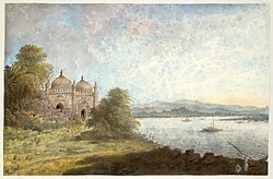 Akbari mosque overlooking the Ganges at Rajmahal
 -
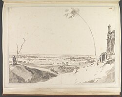 Tomb and Distant View of the Rajmahal Hills, William Hodges, Yale Center for British Art
 -
 Tomb with a distant view of the Rajmahal hills by William Hodges
 -
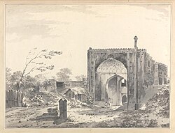 A View of the Gate of the Caravan Serai at Rajmahal, William Hodges, Yale Center for British Art
 -
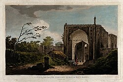 Gateway to a caravan serai at Rajmhal by William Hodges
 -
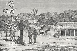 Santal village at Rajmahal (wood etching)
 -
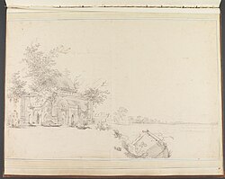 View of a Mausoleum at Rajmahal, 1781, William Hodges, Yale Center for British Art
 -
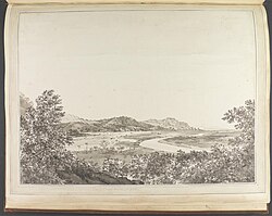 View of the Rajmahal Hills, 1782, William Hodges, Yale Center for British Art
 -
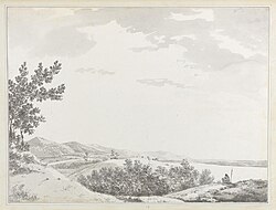 View of the Rajmahal Hills With a Sentenial in the Foreground, William Hodges, Yale Center for British Art
 -
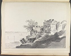 Ruins of Prince Shuja's Palace at Rajmahal, William Hodges, Yale Center for British Art
 -
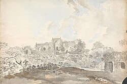 Old Mosque at Rajemahl, Samuel Davis, Yale Center for British Art
 -
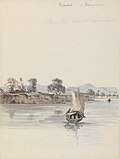 River View near Rajmahal, Samuel Davis, Yale Center for British Art


_by_William_Hodges.jpg)
_-_B1978.43.1726_-_Yale_Center_for_British_Art.jpg)


_-_B1977.14.271_-_Yale_Center_for_British_Art.jpg)

Administration[edit | edit source]
Assembly segments[edit | edit source]
Presently, Rajmahal Lok Sabha constituency comprises the following six Vidhan Sabha (legislative assembly) segments:[14]
| Constituency number | Name | Reserved for (SC/ST/None) | District |
|---|---|---|---|
| 1 | Rajmahal | None | Sahebganj |
| 2 | Borio | ST | Sahebganj |
| 3 | Barhait | ST | Sahebganj |
| 4 | Litipara | ST | Pakur |
| 5 | Pakaur | None | Pakur |
| 6 | Maheshpur | ST | Pakur |
Members of Parliament[edit | edit source]
The Rajmahal (Lok Sabha constituency) is centered around the city and Vijay Kumar Hansdak is the M.P of the region from Jharkhand Mukti Morch.
See also[edit | edit source]
References[edit | edit source]
- ↑ 1.0 1.1 "District Census Handbook, Sahibganj, Series 21, Part XII B" (PDF). Page 25: District Primary Census Abstract, 2011 census. Directorate of Census Operations Jharkhand. Archived (PDF) from the original on 16 November 2020. Retrieved 25 November 2020.
- ↑ Roychoudhury, P.C. (1965). "Bihar District Gazetteers: Santhal Parganas". Chapter I: General. Secretariat Press, Patna, 1965. Retrieved 5 December 2020.
- ↑ "Mansingh, Raja - Banglapedia". en.banglapedia.org. Archived from the original on 3 August 2020. Retrieved 28 September 2020.
- ↑ "Islam Khan Chisti - Banglapedia". en.banglapedia.org. Archived from the original on 2 February 2015. Retrieved 28 September 2020.
- ↑ "Battle of Plassey: God Fought for Great Britain". Probashi. 19 April 2015. Archived from the original on 4 December 2019. Retrieved 25 April 2020.
- ↑ Sarkar, Jadunath (1984). A History of Jaipur, c. 1503-1938, New Delhi: Orient Longman, ISBN 81-250-0333-9, p.81
- ↑ "National Geological Monument, from Geological Survey of India website". Archived from the original on 12 July 2017. Retrieved 21 January 2019.
- ↑ "Geo-Heritage Sites". pib.nic.in. Press Information Bureau. 9 March 2016. Archived from the original on 1 December 2017. Retrieved 15 September 2018.
- ↑ national geo-heritage of India Archived 11 January 2017 at the Wayback Machine, INTACH
- ↑ 2011 census data censusindia.gov.in
- ↑ "District Census Handbook Dumka, Census of India 2011, Series 20, Part XII A" (PDF). Pages 896-902. Directorate of census Operations, Jharkhand. Archived (PDF) from the original on 14 November 2019. Retrieved 23 November 2020.
- ↑ Verma, Brajesh (8 June 2018). "Ancient Gateway of Bengal: Teliagadhi of Jharkhand". Border News. Archived from the original on 2 July 2020. Retrieved 25 April 2020.
- ↑ "Intach aid for Mughal monuments". www.telegraphindia.com. Archived from the original on 5 February 2023. Retrieved 25 April 2020.
- ↑ "Parliamentary Constituency". Chief Electoral Officer, Jharkhand website. Archived from the original on 26 February 2012.
