



->Orenburg1 m ce |
Itsniraj175 (talk | contribs) Revised and enhanced article content |
||
| Line 2: | Line 2: | ||
{{Use Indian English|date=October 2018}} | {{Use Indian English|date=October 2018}} | ||
{{Infobox settlement | {{Infobox settlement | ||
| name | | name = Nediyiruppu | ||
| other_name | | other_name = | ||
| nickname | | nickname = | ||
| settlement_type | | settlement_type = Suburb of [[Kondotty]]<ref name="Suburban_village"/> | ||
| image_skyline | | image_skyline = File:Musliyarangadi, Nediyiruppu, Malappuram Dt,India.jpg | ||
| image_alt | | image_alt = | ||
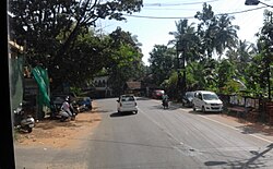
| image_caption | | image_caption = Musliyarangadi Town, Nediyiruppu | ||
| pushpin_map | | pushpin_map = India Kerala#India | ||
| pushpin_label_position | | pushpin_label_position = right | ||
| pushpin_map_alt | | pushpin_map_alt = | ||
| pushpin_map_caption | | pushpin_map_caption = Location in Kerala, India | ||
| coordinates | | coordinates = {{coord|11.1297078|N|76.0021198|E|display=inline,title}} | ||
| subdivision_type | | subdivision_type = Country | ||
| subdivision_name | | subdivision_name = {{flag|India}} | ||
| subdivision_type1 | | subdivision_type1 = [[States and territories of India|State]] | ||
| subdivision_name1 | | subdivision_name1 = [[Kerala]] | ||
| subdivision_type2 | | subdivision_type2 = [[List of districts of India|District]] | ||
| subdivision_name2 | | subdivision_name2 = [[Malappuram district|Malappuram]] | ||
| established_title | | established_title = <!-- Established --> | ||
| established_date | | established_date = | ||
| founder | | founder = | ||
| named_for | | named_for = | ||
| government_type | | government_type = | ||
| governing_body | | governing_body = | ||
| unit_pref | | unit_pref = Metric | ||
| area_footnotes | | area_footnotes = | ||
| area_rank | | area_rank = | ||
| area_total_km2 | | area_total_km2 = | ||
| elevation_footnotes | | elevation_footnotes = | ||
| elevation_m | | elevation_m = | ||
| population_total | | population_total = 30462 | ||
| population_as_of | | population_as_of = 2011 | ||
| population_rank | | population_rank = | ||
| population_density_km2 | | population_density_km2 = auto | ||
| population_demonym | | population_demonym = | ||
| population_footnotes | | population_footnotes = | ||
| demographics_type1 | | demographics_type1 = Languages | ||
| demographics1_title1 | | demographics1_title1 = Official | ||
| demographics1_info1 | | demographics1_info1 = [[Malayalam language|Malayalam]] | ||
| timezone1 | | timezone1 = [[Indian Standard Time|IST]] | ||
| utc_offset1 | | utc_offset1 = +5:30 | ||
| postal_code_type | | postal_code_type = <!-- [[Postal Index Number|PIN]] --> | ||
| postal_code | | postal_code = | ||
| registration_plate | | registration_plate = KL-84 | ||
| website | | website = | ||
| footnotes | | footnotes = | ||
}} | }} | ||
'''Nediyiruppu''' is a region of the [[Kondotty|Kondotty municipality]] in [[Malappuram district]], [[Kerala]], India.<ref name="Suburban_village">{{cite news |last1=Special Currespondent |title=Nediyiruppu village merges with Kondotty municipality |url=https://www.thehindu.com/news/cities/Thiruvananthapuram/nod-for-30-municipalities-kannur-corporation/article7161008.ece |accessdate=16 July 2020 |agency=The Hindu | | '''Nediyiruppu''' was the capital of the [[Zamorin]]'s kingdom in colonial [[Kerala]]. At the time, it was known as '''Nediyiruppu Swaroopam'''. It is a region of the [[Kondotty|Kondotty municipality]] in [[Malappuram district]], [[Kerala]], India.<ref name="Suburban_village">{{cite news |last1=Special Currespondent |title=Nediyiruppu village merges with Kondotty municipality |url=https://www.thehindu.com/news/cities/Thiruvananthapuram/nod-for-30-municipalities-kannur-corporation/article7161008.ece |accessdate=16 July 2020 |agency=The Hindu |work=The Hindu |date=1 May 2015}}</ref> It is situated {{convert|24|km}} from [[Malappuram]], the district headquarters. | ||
==History== | ==History== | ||
Nediyiruppu was the headquarters of the [[Zamorin of Calicut|Zamorin]] rulers of the Kingdom of Calicut (the kingdom was called ''Nediyiruppu Swaroopam'' at that time).<ref name="lsgkerala.in Social History">{{cite web |title=ചരിത്രം: സാമൂഹ്യചരിത്രം |trans-title=History: Social History |url=http://lsgkerala.in/nediyiruppupanchayat/history/ |website=Nediyiruppu Grama Panchayat |language=Malayalam |access-date=20 August 2018}}</ref> | Nediyiruppu was the headquarters of the [[Zamorin of Calicut|Zamorin]] rulers of the Kingdom of Calicut (the kingdom was called ''Nediyiruppu Swaroopam'' at that time).<ref name="lsgkerala.in Social History">{{cite web |title=ചരിത്രം: സാമൂഹ്യചരിത്രം |trans-title=History: Social History |url=http://lsgkerala.in/nediyiruppupanchayat/history/ |website=Nediyiruppu Grama Panchayat |language=Malayalam |access-date=20 August 2018 |archive-date=4 June 2016 |archive-url=https://web.archive.org/web/20160604203620/http://lsgkerala.in/nediyiruppupanchayat/history/ |url-status=dead }}</ref> | ||
According to some other historians, the wealth of Manavikrama royalty was kept in a treasury at Nediyiruppu | According to some other historians, the wealth of Manavikrama royalty was kept in a treasury at Nediyiruppu named ''Nedi-Iruppu'' meaning "got-and-placed". The treasury was located in Viruthiyil Paramba in Nediyiruppu.<ref name="lsgkerala.in Social History"/> | ||
Nediyiruppu village is a part of the [[Kondotty]] municipality. | Nediyiruppu village is a part of the [[Kondotty]] municipality. | ||
| Line 62: | Line 62: | ||
{{As of|2011}} India [[2011 Census of India|census]], Nediyiruppu had a population of 30,462 with 14,859 males and 15,603 females.<ref name="censusindia2011">{{cite web |last=Registrar General & Census Commissioner, India |title=Nediyiruppu Population - Malappuram, Kerala |url=http://www.census2011.co.in/data/village/627455-nediyiruppu-kerala.html |access-date=21 August 2018}}</ref> In 2015, Nediyiruppu Grama Panchayath and Kondotty Grama Panchayath merged to form a new Kondotty municipality. | {{As of|2011}} India [[2011 Census of India|census]], Nediyiruppu had a population of 30,462 with 14,859 males and 15,603 females.<ref name="censusindia2011">{{cite web |last=Registrar General & Census Commissioner, India |title=Nediyiruppu Population - Malappuram, Kerala |url=http://www.census2011.co.in/data/village/627455-nediyiruppu-kerala.html |access-date=21 August 2018}}</ref> In 2015, Nediyiruppu Grama Panchayath and Kondotty Grama Panchayath merged to form a new Kondotty municipality. | ||
Most of the people of this village are farmers. Some of them also work in [[Arab States of the Persian Gulf|Persian Gulf countries]] | Most of the people of this village are farmers. Some of them also work in [[Arab States of the Persian Gulf|Persian Gulf countries]]. There is a very good level of affluence in the village because of remittances from workers in the [[Persian Gulf]] region.{{Citation needed|date=October 2024}} | ||
The biggest [[Harijan]] colony in the state of Kerala is located in Nediyiruppu village, on a hillock called Colony Road.<ref name="lsgkerala.in Description">{{cite web |title=പഞ്ചായത്തിലൂടെ |trans-title=Description of the Panchayat |url=http://lsgkerala.in/nediyiruppupanchayat/general-information/description/ |website=Nediyiruppu Grama Panchayat |language=Malayalam |access-date=20 August 2018}}</ref> | The biggest [[Harijan]] colony in the state of Kerala is located in Nediyiruppu village, on a hillock called Colony Road.<ref name="lsgkerala.in Description">{{cite web |title=പഞ്ചായത്തിലൂടെ |trans-title=Description of the Panchayat |url=http://lsgkerala.in/nediyiruppupanchayat/general-information/description/ |website=Nediyiruppu Grama Panchayat |language=Malayalam |access-date=20 August 2018 |archive-date=4 June 2016 |archive-url=https://web.archive.org/web/20160604121525/http://lsgkerala.in/nediyiruppupanchayat/general-information/description/ |url-status=dead }}</ref> | ||
==Administration== | ==Administration== | ||
Nediyiruppu village merged with the [[Kondotty|Kondotty municipality]] in 2015. It is now a part of the municipality.<ref name="Suburban_village"/> | Nediyiruppu village merged with the [[Kondotty|Kondotty municipality]] in 2015. It is now a part of the municipality.<ref name="Suburban_village"/> | ||
==Suburbs and villages== | ==Suburbs and villages== | ||
* | * Important places in Nediyiruppu Village include Musliarangadi, Nediyiruppu (formerly Colony Road Junction),Kottukara, Meleparambu, Chirayil Chungam, Kodangad, and Kurupath. Historically, Nediyiruppu is significant as the capital of the Zamorin dynasty. In remembrance of this heritage, Nediyiruppu Swaroopam Road in Poyilikkave was named to honor its historical importance. | ||
*''[[Mongam]]'' and ''Moayur'' are two villages lying between the towns of Musliyarangadi and [[Valluvambram Junction|Valluvambram]]. Morayur, in [[Malayalam]], means " | *''[[Mongam]]'' and ''Moayur'' are two villages lying between the towns of Musliyarangadi and [[Valluvambram Junction|Valluvambram]]. Morayur, in [[Malayalam]], means "land of peoples who have manners". [[Thinayancherry Elayath]], a native of Morayur, was a minister of one of the [[Zamorin]] kings. Anwarul Islam Women's Arabic College is an Arabic college located in Mongam and is affiliated to the University of Calicut. | ||
*At Valluvambram Junction the road from Kozhikode meets ''Manjeri Road'' and ''Malappuram Road''. ''Manjeri Road'' goes to [[Nilambur]], [[Ooty]], and [[Mysore]]. ''Malappuram Road'' goes to [[Guruvayur]] and [[Thrissur]]. Despite the importance of the junction, the village of Valluvambram remains very rural, except for some large commercial developments on the sides of the main roads. | *At Valluvambram Junction the road from Kozhikode meets ''Manjeri Road'' and ''Malappuram Road''. ''Manjeri Road'' goes to [[Nilambur]], [[Ooty]], and [[Mysore]]. ''Malappuram Road'' goes to [[Guruvayur]] and [[Thrissur]]. Despite the importance of the junction, the village of Valluvambram remains very rural, except for some large commercial developments on the sides of the main roads. | ||
* Other suburbs are Kodangad, Kuruppath, Pothuvettypara, Kottukkara, [[Mongam]], Morayur, [[Arimbra]] Hills, Millumpady, Iruveengal, Colony Road, Ozhukur, Thurakkal, Kolathur, and Thalekkara. | * Other suburbs are Kodangad, Kuruppath, Pothuvettypara, Kottukkara, [[Mongam]], Morayur, [[Arimbra]] Hills, Millumpady, Iruveengal, Colony Road, Ozhukur, Thurakkal, Kolathur, and Thalekkara. | ||
==Transportation== | ==Transportation== | ||
[[File:Nediyiruppu Swaroopam road at Poyilikkave Nediyiruppu.jpg|'''Nediyiruppu Swaroopam Road''' at Poyilikkave in Nediyiruppu |thumb|280x280px]] | [[File:Nediyiruppu Swaroopam road at Poyilikkave Nediyiruppu.jpg|'''Nediyiruppu Swaroopam Road''' at Poyilikkave in Nediyiruppu|thumb|280x280px]] | ||
[[File:Musliyarangadi.jpg|thumbnail|Upper Musliyarangadi|280x280px]] | [[File:Musliyarangadi.jpg|thumbnail|Upper Musliyarangadi|280x280px]] | ||
[[File:Poyilikkave karinkali temple.jpg|thumb|Poyilikkavu Karinkali Temple,Nediyiruppu|280x280px]] | [[File:Poyilikkave karinkali temple.jpg|thumb|Poyilikkavu Karinkali Temple, Nediyiruppu|280x280px]]Nediyiruppu village connects to other parts of India through [[Feroke]] town on the west and [[Nilambur]] town on the east. [[National Highway 66 (India)|National Highway 66]] passes through [[Musliyarangadi]], connecting to [[Goa]] and [[Mumbai]], to the north, and to [[Cochin]] and [[Trivandrum]], to the south. [[State Highway 28 (Kerala)|State Highway 28]] starts at Nilambur and connects to [[Ooty]], [[Mysore]], and [[Bangalore]] through state highways [[State Highway 12 (Kerala)|12]], [[State Highway 29 (Kerala)|29]], and 181. | ||
Nediyiruppu village connects to other parts of India through [[Feroke]] town on the west and [[Nilambur]] town on the east. [[National Highway 66 (India)|National Highway 66]] passes through [[Musliyarangadi]], connecting to [[Goa]] and [[Mumbai]], to the north, and to [[Cochin]] and [[Trivandrum]], to the south. [[State Highway 28 (Kerala)|State Highway 28]] starts at Nilambur and connects to [[Ooty]], [[Mysore]], and [[Bangalore]] through state highways [[State Highway 12 (Kerala)|12]], [[State Highway 29 (Kerala)|29]], and 181. | |||
The nearest major railway station is at [[Feroke]]. The nearest airport is at [[Kozhikode Airport|Kozhikode]]. | The nearest major railway station is at [[Feroke]]. The nearest airport is at [[Kozhikode Airport|Kozhikode]]. | ||
| Line 124: | Line 92: | ||
[[Duff muttu|Duff Muttu]], [[Kolkali]], and [[Aravana]]muttu are common folk arts of this locality.<ref name="lsgkerala.in Social History"/> | [[Duff muttu|Duff Muttu]], [[Kolkali]], and [[Aravana]]muttu are common folk arts of this locality.<ref name="lsgkerala.in Social History"/> | ||
The Hindu minority maintains their traditions by celebrating various festivals in their temples. Hindu rituals are performed here with a regular devotion, as in other parts of Kerala.<ref>{{cite web |url=http://www.malappuram.net/art-and-culture.htm |title= | The Hindu minority maintains their traditions by celebrating various festivals in their temples. Hindu rituals are performed here with a regular devotion, as in other parts of Kerala.<ref>{{cite web |url=http://www.malappuram.net/art-and-culture.htm |title=Malappuram News, Malappuram District Map, Malappuram Muslim, Malappuram Hospitals, Malappuram College, Malappuram Directory |accessdate=2016-07-14 |url-status=dead |archiveurl=https://web.archive.org/web/20160401052519/http://malappuram.net/art-and-culture.htm |archivedate=2016-04-01 }}</ref> | ||
== | ==Notable landmarks== | ||
*''Poyilikkave Karinkali Temple'' is an ancient temple in Nediyiruppu that was constructed during Zamorins period. The capital of the Zamorins was at Nediyiruppu Swaroopam, which made this temple important. The Thalapoli festival worshipping Goddess Karinkali Devi is held in December of every year. | *''Poyilikkave Karinkali Temple'' is an ancient temple in Nediyiruppu that was constructed during Zamorins period. The capital of the Zamorins was at Nediyiruppu Swaroopam, which made this temple important. The Thalapoli festival worshipping Goddess Karinkali Devi is held in December of every year. | ||
*''Pandikashala Mosque'' in Musliyarangadi is the biggest mosque in the village. The mosque has intricate carvings of verses from the Quran on doors and windows. There is one ''Dargah'' of a holy man in this mosque. | *''Pandikashala Mosque'' in Musliyarangadi is the biggest mosque in the village. The mosque has intricate carvings of verses from the Quran on doors and windows. There is one ''Dargah'' of a holy man in this mosque. | ||
| Line 161: | Line 129: | ||
* [[Arimbra]] | * [[Arimbra]] | ||
* [[Pookkottur]] | * [[Pookkottur]] | ||
* | * Kottukkara School | ||
==References== | ==References== | ||
{{reflist}} | {{reflist}} | ||
{{Malappuram district}} | {{Malappuram district}} | ||
[[Category:Cities and towns in Malappuram district]] | [[Category:Cities and towns in Malappuram district]] | ||
[[Category:Kondotty area]] | [[Category:Kondotty area]] | ||
Latest revision as of 21:14, 2 February 2026
Nediyiruppu | |
|---|---|
 Musliyarangadi Town, Nediyiruppu | |
  Nediyiruppu Location in Kerala, India  Nediyiruppu Nediyiruppu (India) | |
| Coordinates: 11°07′47″N 76°00′08″E / 11.1297078°N 76.0021198°E | |
| Country |  India India |
| State | Kerala |
| District | Malappuram |
| Population (2011) | |
| • Total | 30,462 |
| Languages | |
| • Official | Malayalam |
| Time zone | UTC+5:30 (IST) |
| Vehicle registration | KL-84 |
Nediyiruppu was the capital of the Zamorin's kingdom in colonial Kerala. At the time, it was known as Nediyiruppu Swaroopam. It is a region of the Kondotty municipality in Malappuram district, Kerala, India.[1] It is situated 24 kilometres (15 mi) from Malappuram, the district headquarters.
History[edit | edit source]
Nediyiruppu was the headquarters of the Zamorin rulers of the Kingdom of Calicut (the kingdom was called Nediyiruppu Swaroopam at that time).[2]
According to some other historians, the wealth of Manavikrama royalty was kept in a treasury at Nediyiruppu named Nedi-Iruppu meaning "got-and-placed". The treasury was located in Viruthiyil Paramba in Nediyiruppu.[2]
Nediyiruppu village is a part of the Kondotty municipality.
Demographics[edit | edit source]
As of 2011[update] India census, Nediyiruppu had a population of 30,462 with 14,859 males and 15,603 females.[3] In 2015, Nediyiruppu Grama Panchayath and Kondotty Grama Panchayath merged to form a new Kondotty municipality.
Most of the people of this village are farmers. Some of them also work in Persian Gulf countries. There is a very good level of affluence in the village because of remittances from workers in the Persian Gulf region.[citation needed]
The biggest Harijan colony in the state of Kerala is located in Nediyiruppu village, on a hillock called Colony Road.[4]
Administration[edit | edit source]
Nediyiruppu village merged with the Kondotty municipality in 2015. It is now a part of the municipality.[1]
Suburbs and villages[edit | edit source]
- Important places in Nediyiruppu Village include Musliarangadi, Nediyiruppu (formerly Colony Road Junction),Kottukara, Meleparambu, Chirayil Chungam, Kodangad, and Kurupath. Historically, Nediyiruppu is significant as the capital of the Zamorin dynasty. In remembrance of this heritage, Nediyiruppu Swaroopam Road in Poyilikkave was named to honor its historical importance.
- Mongam and Moayur are two villages lying between the towns of Musliyarangadi and Valluvambram. Morayur, in Malayalam, means "land of peoples who have manners". Thinayancherry Elayath, a native of Morayur, was a minister of one of the Zamorin kings. Anwarul Islam Women's Arabic College is an Arabic college located in Mongam and is affiliated to the University of Calicut.
- At Valluvambram Junction the road from Kozhikode meets Manjeri Road and Malappuram Road. Manjeri Road goes to Nilambur, Ooty, and Mysore. Malappuram Road goes to Guruvayur and Thrissur. Despite the importance of the junction, the village of Valluvambram remains very rural, except for some large commercial developments on the sides of the main roads.
- Other suburbs are Kodangad, Kuruppath, Pothuvettypara, Kottukkara, Mongam, Morayur, Arimbra Hills, Millumpady, Iruveengal, Colony Road, Ozhukur, Thurakkal, Kolathur, and Thalekkara.
Transportation[edit | edit source]


Nediyiruppu village connects to other parts of India through Feroke town on the west and Nilambur town on the east. National Highway 66 passes through Musliyarangadi, connecting to Goa and Mumbai, to the north, and to Cochin and Trivandrum, to the south. State Highway 28 starts at Nilambur and connects to Ooty, Mysore, and Bangalore through state highways 12, 29, and 181.
The nearest major railway station is at Feroke. The nearest airport is at Kozhikode.
Economy[edit | edit source]
The main income of the village is from remittances from Persian Gulf countries like Saudi Arabia. A large number of the locals also work in the agrarian sector. Small industries like hollow bricks, wood cutting, granite quarries, and matchbox units exist in the village. The only available petrol bunker is located at Kurupath Junction.
Culture[edit | edit source]
Nediyiruppu village has six temples, 20 mosques, and 21 Madrassas. It is a predominantly Muslim area, with Hindus in comparatively smaller numbers, so the culture of the locality is based upon Muslim traditions.[2]
People gather in mosques for evening prayer and continue to sit there after the prayers, discussing social and cultural issues. Business and family issues are also sorted out during these evening meetings. There are many libraries attached to mosques that are a rich source of Islamic studies. Some of the books are written in Arabi-Malayalam which is a version of the Malayalam language written in Arabic script.[2]
Duff Muttu, Kolkali, and Aravanamuttu are common folk arts of this locality.[2]
The Hindu minority maintains their traditions by celebrating various festivals in their temples. Hindu rituals are performed here with a regular devotion, as in other parts of Kerala.[5]
Notable landmarks[edit | edit source]
- Poyilikkave Karinkali Temple is an ancient temple in Nediyiruppu that was constructed during Zamorins period. The capital of the Zamorins was at Nediyiruppu Swaroopam, which made this temple important. The Thalapoli festival worshipping Goddess Karinkali Devi is held in December of every year.
- Pandikashala Mosque in Musliyarangadi is the biggest mosque in the village. The mosque has intricate carvings of verses from the Quran on doors and windows. There is one Dargah of a holy man in this mosque.
- Thiruvonamala Temple, near Harijan Colony Road.
- Chirayil Chungath Jumaeth Palli, 400 years old, with a 250-year-old carved Mimbre.
- Ayyappa Temple, Chirayil.
Mini Ooty Hills[edit | edit source]
.jpg)
.jpg)

Mini Ooty, or Arimbra Hills, is a small village about 10 kilometres (6.2 mi) from Nediyiruppu. It is a 500 metres (1,600 ft) steep climb from the main road. Mini Ooty can be accessed from Musliyarangadi, Colony Road, Pookkottoor, or Vengara. The route to Mini Ooty passes other small villages, such as Melaparamba, Angadi, Thazhe Colony, Moochikundu, Poolappees and Thiruvonamoola. The roads are in good condition, and a moderately large number of visitors come to see the rolling hills and scenic views. There are many stone crushers and plantations atop the hills. There is an old Dalit colony on the western side of the hill. The hilltop colony in this village was marked officially as Neidiyiruppu on a milestone placed at the road junction. This junction is called Colony Road Junction, after the Harijan colony, Kerala's first, in this village.
Location[edit | edit source]
Areas Of Nediyiruppu | ||||||||||
|---|---|---|---|---|---|---|---|---|---|---|
| ||||||||||


See also[edit | edit source]
- Kondotty
- Valluvambram Junction
- Arimbra
- Pookkottur
- Kottukkara School
References[edit | edit source]
- ↑ 1.0 1.1 1.2 Special Currespondent (1 May 2015). "Nediyiruppu village merges with Kondotty municipality". The Hindu. The Hindu. Retrieved 16 July 2020.
- ↑ 2.0 2.1 2.2 2.3 2.4 "ചരിത്രം: സാമൂഹ്യചരിത്രം" [History: Social History]. Nediyiruppu Grama Panchayat (in Malayalam). Archived from the original on 4 June 2016. Retrieved 20 August 2018.
{{cite web}}: CS1 maint: unrecognized language (link) - ↑ Registrar General & Census Commissioner, India. "Nediyiruppu Population - Malappuram, Kerala". Retrieved 21 August 2018.
- ↑ "പഞ്ചായത്തിലൂടെ" [Description of the Panchayat]. Nediyiruppu Grama Panchayat (in Malayalam). Archived from the original on 4 June 2016. Retrieved 20 August 2018.
{{cite web}}: CS1 maint: unrecognized language (link) - ↑ "Malappuram News, Malappuram District Map, Malappuram Muslim, Malappuram Hospitals, Malappuram College, Malappuram Directory". Archived from the original on 1 April 2016. Retrieved 14 July 2016.