





WikiDwarfBOT (talk | contribs) Cleanup: Source modification. Information added. |
minor changes |
||
| Line 1: | Line 1: | ||
{{About|the | {{About|the city in Tamil Nadu, India|its namesake district|Tirunelveli district}} | ||
{{protection padlock|small=yes}} | |||
{{Use Indian English|date=June 2016}} | {{Use Indian English|date=June 2016}} | ||
{{Use dmy dates|date=August 2022}} | {{Use dmy dates|date=August 2022}} | ||
{{Infobox settlement | {{Infobox settlement | ||
| name | | name = Tirunelveli | ||
| official_name | | official_name = | ||
| other_name | | other_name = | ||
| settlement_type | | settlement_type = [[City]] | ||
| image_skyline | | image_skyline = {{multiple image | ||
|perrow = 1/2/2/2 | |||
|border = infobox | |||
|total_width = 300 | |||
|image1 = TirunelveliPanorama.jpg | |||
|caption1 = City skyline | |||
|image2 = Nellaiappar_temple_tower.jpg | |||
|caption2 = [[Nellaiappar Temple]] | |||
|image3 = Tirunelvelijunction.JPG | |||
|caption3 = [[Tirunelveli Junction railway station|Tirunelveli Junction]] | |||
| | |image4 = Thamirabarani River தாமிரபரணி பொருணை ஆறு.jpg | ||
| | |caption4 = [[Thamirabarani River]] | ||
| | |image5 = A inner view of Manomaniam Sundaranar University building.jpg | ||
| | |caption5 = [[Manonmaniam Sundaranar University]] | ||
| | |image6 = Sulochana Mudaliar Bridge Upstream Tirunelveli Sep22 A7C 02382.jpg | ||
| | |caption6 = [[:ta:சுலோச்சன முதலியார் பாலம்|Sulochana Mudaliar Bridge]] | ||
| | |image7 = CentralTheatreTvli.jpg | ||
| | |caption7 = Central Theatre | ||
| | |||
| | |||
| | |||
| | |||
| | |||
| | |||
| | |||
| | |||
| | |||
| | |||
}} | }} | ||
[[ | | image_alt = | ||
| image_caption = | |||
| map_alt = | |||
| map_caption = | |||
| nickname = [[Oxford]] of South India<ref>{{cite web |last=Sudhakar |first=P |date=19 May 2016 |title=Palayamkottai electorate earn a dubious distinction |url=https://www.thehindu.com/news/national/tamil-nadu/palayamkottai-electorate-earn-a-dubious-distinction/article8618426.ece |access-date=14 September 2024 |work=[[The Hindu]] |language=en-IN |issn=0971-751X}}</ref><ref>{{cite web |last=Mallady |first=Shastry V |date=10 September 2012 |title=A case for Madurai |url=https://www.thehindu.com/features/education/college-and-university/a-case-for-madurai/article3880992.ece |access-date=14 September 2024 |work=[[The Hindu]] |language=en-IN |issn=0971-751X}}</ref> | |||
| pushpin_map = India Tamil Nadu#India3 | |||
| pushpin_label_position = right | |||
| pushpin_map_alt = | |||
| pushpin_map_caption = Tirunelveli, Tamil Nadu | |||
| coordinates = {{Coord|8|42|49|N|77|45|24|E|region:IN|display=inline,title}} | |||
| subdivision_type = Country | |||
| subdivision_name = India | |||
| subdivision_type1 = [[States and union territories of India|State]] | |||
| subdivision_name1 = [[Tamil Nadu]] | |||
| subdivision_type2 = [[Administrative divisions of India|Region]] | |||
| subdivision_name2 = [[Pandya Nadu]] | |||
| subdivision_type3 = [[List of districts in India|District]] | |||
| subdivision_name3 = [[Tirunelveli District|Tirunelveli]] | |||
| established_title = <!-- Established --> | |||
| established_date = | |||
| founder = | |||
| named_for = | |||
| government_type = [[Municipal Corporation]] | |||
| governing_body = [[Tirunelveli City Municipal Corporation]] | |||
| leader_title = Mayor | |||
| leader_name = | |||
| parts_style = para | |||
| unit_pref = Metric | |||
| area_footnotes = | |||
| area_total_km2 = 189.9 | |||
| area_rank = 3 | |||
| elevation_footnotes = | |||
| elevation_m = 73 | |||
| population_total = 473637 | |||
| population_as_of = 2011 | |||
| population_footnotes = <ref name="census">{{cite web |title=Census 2011 |url=https://censusindia.gov.in/census.website/data/population-finder |website=The Registrar General & Census Commissioner, India |publisher=The Registrar General & Census Commissioner, India |access-date=20 April 2024}}</ref> | |||
| population_density_km2 = auto | |||
| population_rank = [[List of cities in Tamil Nadu by population|7th in Tamil Nadu]] | |||
| population_metro = 498924 | |||
| population_demonym = Tirunelvelian, Nellaikaran | |||
| demographics_type1 = Languages | |||
| demographics1_title1 = Official | |||
| demographics1_info1 = [[English language|English]], [[Tamil language|Tamil]] | |||
| timezone1 = [[Indian Standard Time|IST]] | |||
| utc_offset1 = +5:30 | |||
| postal_code_type = [[Postal Index Number|Pin Codes]] | |||
| postal_code = 627xx | |||
| area_code = [[Telephone numbers in India#Fixed (landline) numbers|91 (0)462]] | |||
| area_code_type = Telephone code | |||
| registration_plate = TN 72 | |||
| website = {{url|https://tirunelveli.nic.in/}} | |||
| website developer = | |||
| mail id = | |||
}} | |||
'''Tirunelveli''' ({{IPA|ta|tiɾɯnelʋeːli|lang|Tirunelveli-pronunciation.ogg}}),{{efn|name=Name|Anglicised as Tinnevelly during the [[British Raj]]}} also known as '''Nellai''', is a city and [[List of municipal corporations in Tamil Nadu|municipal corporation]] in the Indian state of [[Tamil Nadu]]. It is located on the southern part of the state, on the west bank of the [[Thamirabarani River]]. It is the administrative headquarters of the [[Tirunelveli District]]. As per the [[2011 Census of India|2011 census]], it had a population of 473,637 individuals, and was the [[List of cities in Tamil Nadu by population|seventh-largest]] city in the state by population. | |||
Tirunelveli | Tirunelveli has a recorded history dating back to more than two thousand years. It served as a major town during the reign of the [[Early Pandyan Kingdom|Early Pandyas]] in the [[Sangam period]] (3rd century BCE to 3rd century CE). It came under the rule of the [[Cholas]] in the 11th century CE. The region was ruled by the [[Later Pandyas]], the [[Vijayanagara Empire]], and the [[Madurai Nayaks]] in the late [[Middle Ages]]. It came under the influence of the [[British East India Company]] in the late 18th century, and the [[Tirunelveli District|Tinnevelly district]] was formed on 1 September 1790. In the [[Polygar War]], [[Palaiyakkarar]]s led by [[Veerapandiya Kattabomman]] fought the forces of the Company, on the outskirts of the city from 1797 to 1801. It came under the [[British Raj]] in the 19th century, and later became part of the [[Madras Province]] of Independent India in 1947. | ||
Tirunelveli is administered by the [[Tirunelveli | Tirunelveli is administered by the [[Tirunelveli Municipal Corporation]], which was established on 1 June 1994. The city covers an area of {{cvt|189.9|km2}}. It is well-connected by road and rail with the rest of the state. The economy of the city is dependent on [[agriculture]] and its allied industries, services including education, and information technology, manufacturing including [[tobacco]] products, [[cement]], and [[bricks]], and textiles. There are several [[wind power]] generation farms located in the outskirts of the city. The city serves an educational hub of the region, and is home to several institutions. | ||
Tirunelveli has a number of historical monuments, with the [[Nellaiappar Temple]] being the most prominent. The city is renowned for the sweet of '[[Iruttu Kadai|Irutu kadai]] [[halva]]'. | |||
Tirunelveli has a number of historical monuments, with the [[Nellaiappar Temple]] being the most prominent. The city is | |||
==Etymology== | ==Etymology== | ||
The inscriptions at the [[Nellaiappar Temple]] mention that [[Shiva]] (as Vrihivriteswara) descended to the Earth and took the form of a [[hedge]] to save the [[rice|paddy]] crop of a devotee. As per the earlier practice of naming settlements based on the vegetation prevalent in the areas of worship,{{sfn|Reddy|2013|p=10}} the place was known as 'Venu vanam' ([[bamboo]] forest) due to the presence of bamboo where the deity is believed to have appeared.{{sfn|Ayyar|1982|p=498–499}} Derived from the story in the [[Hindu mythology]], 'Tirunelveli' is a combination of three Tamil words–'thiru', 'nel', and 'veli', meaning sacred, paddy, and hedge respectively.{{sfn|Kannappan|2008|p=67}}{{sfn|Caldwell|1990|p=88}} The seventh-century [[Saivism|Saiva]] canonical work ''[[Tevaram]]'' mentions the town as 'Thirunelveli'.<ref>{{cite web|title=Moondram Thirumurai|author=[[Sambandar]]|url=http://www.thevaaram.org/thirumurai_1/songview.php?thiru=3&Song_idField=3092&padhi=126+&button=செல்க|publisher=Thevaram.org|access-date=8 June 2012}}</ref> The town was called Tirunelveli Seemai during the late [[Middle Ages]], with 'seemai' meaning town in Tamil. It was anglicised as 'Tinnelvelly' during the [[British Raj]], and was officially named Tirunelveli after the Indian independence.{{sfn|Caldwell|1990|p=88}}{{sfn|Kanmony|2010|p=42}} | |||
==History== | ==History== | ||
Tirunelveli was part of the [[Pandian Empire]], references to which are present in the [[Sangam literature]], and inscriptions dating back to the 3rd century BCE.{{sfn|Caldwell|1989|p=14–16}} The region came under the rule of the [[Cholas]] in the 11th century CE.{{sfn|Caldwell|1989|p=27–29}} It remained under the control of the Cholas until the early 13th century CE, when the Pandyas re-established control over the region, and ruled with [[Madurai]] as the capital.{{sfn|Salma Ahmed|2011|p=26}} During the 13th and 14th centuries, Tirunelveli was the secondary capital of Pandimandalam, the country ruled by the Pandyas.{{sfn|Stein|Johnson|Bayly|Richards|1990|p=79}} | |||
Tirunelveli was | |||
The | [[File:Nellaiappar_Temple10.jpg|left|thumb|upright=0.75|The [[Nellaiappar Temple]] was built by the [[Later Pandyas]]]] | ||
The | The Nellaiappar temple was the royal shrine of the later Pandyas, and the city benefited from extensive [[irrigation]] facilities were developed based on the [[Thamirabarani River]]. The [[Vijayanagara Empire]] occupied the region in the 15th century CE. During the Vijayanagara rule, [[Brahmin]] and [[Vellalar]] chieftains held rights over community lands ('kani') in the Thamirabarani valley, while [[Maravar]] and Shanar migrants settled around the region. The Maravars populated the western foothills, the [[Kannadigas]] and [[Telugus]] settled on the eastern dry tracts of land.{{sfn|Stein|Johnson|Bayly|Richards|1990|p=79}} In the 16th century CE, the region was ruled by the [[Madurai Nayaks]], and Tirunelveli served as the subsidiary capital of the Nayak territory.{{sfn|Stein|Johnson|Bayly|Richards|1989|p=80}} The city was rebuilt extensively during the reign of [[Viswanatha Nayak]] (1529–64), who also developed several temples in the region.{{sfn|Hunter|1908|p=379–380}} | ||
The region briefly came under the control of [[Nawabs of Arcot]] after they defeated the [[Marathas]] in 1743 CE. However, during the time, the [[palaiyakkarar]]s, who were originally military governors under the Nayak rule, held control over the lands. In the middle of the 18th century, the [[British East India Company]] began to establish control over the lands in the region.{{sfn|Francis|2002|p=260}}{{sfn|Hunter|1908|p=375}} Between the 15th and 18th centuries, Tirunelveli became a major economic center in the region, with migration of people to the city.{{sfn|Kumar|2003|p=113–115}} During the 18th century, the town was often called as Nellai Cheemai, with 'Cheemai' meaning 'foreign town'.<ref>{{cite web |url=http://www.hindu.com/2007/05/19/stories/2007051909370400.htm |title=400 years sugar cane press |date=19 May 2007 |work=[[The Hindu]] |access-date=18 December 2012}}</ref> | |||
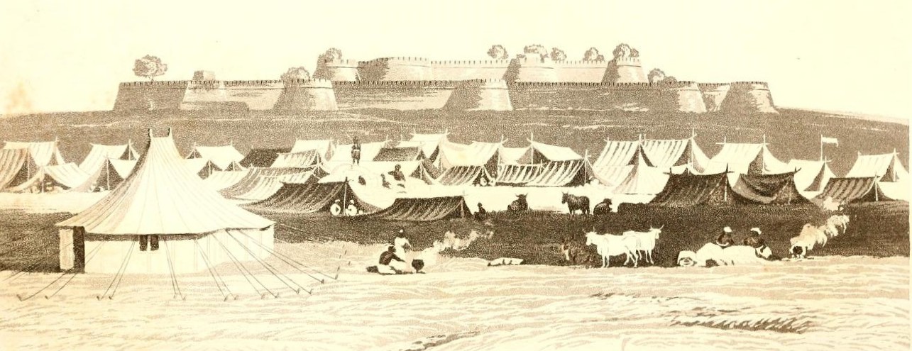
[[File:0088_View_of_Comery_(1801).jpg|thumb|[[Polygar Wars]] were fought between the [[Palaiyakkarars]], the local chieftains and the [[British East India Company]]]] | |||
Though the British restored some order in 1755 CE, the palaiyakkarars, who had built massive forts, and held their own armies, continued to fight with the British, and within themselves. Briefly, the British had it troops in the region, while the palaiyakkarars managed the territory on behalf of the Nawabs.{{sfn|Francis|2002|p=260}} However, the palaiyakkarars later continued to engage in skirmishes with the British. This culminated in the [[Polygar Wars]], in which a group of palaiyakkarars, led by [[Veerapandiya Kattabomman]], fought against the British, who were also aided by some of the palaiyakkarars. Kattabomman was defeated and hanged, and eventually the region came under the complete control of the British in 1801 CE.{{sfn|Hunter|1908|p=375–379}}{{sfn|Caldwell|1989|p=93–94}}{{sfn|Francis|2002|p=260}} | |||
[[Tirunelveli district|Tinnevelly district]] was established on 1 September 1790, with Tinnevelly serving as the headquarters of the district.<ref>{{cite web |url=https://tirunelveli.nic.in/home3/ |title=Tirunelveli district |work=[[Government of Tamil Nadu]] |access-date=1 June 2025}}</ref> The history of Tirunelveli was extensively researched and documented by [[Robert Caldwell]] (1814–91), a Christian [[missionary]] who visited the area in the early 19th century CE.{{sfn|Daughrity|2005}}{{sfn|Daughrity|2007}} [[Palayamkottai]], which housed the old fort built by the palaiyakkarars, served as a garrison.{{sfn|Francis|2002|p=261}} Tirunelveli was part of the [[Madras Presidency]] during the [[British Raj]].{{sfn|Stuart|1879|p=1}} After Indian independence, it became part of the [[Madras Province]], which later became the [[Madras State]] in 1950, and Tamil Nadu in 1969.<ref>{{cite web |url=https://www.thenewsminute.com/tamil-nadu/50-years-look-how-madras-state-became-tamil-nadu-85108 |title=50 years on, a look at how Madras State became Tamil Nadu |work=News Minute |access-date=1 June 2025 }}</ref> | |||
==Geography== | ==Geography== | ||
[[File:Agasthiyamalai range and Tirunelveli rainshadow.jpg|thumb| | [[File:Central Veinthaan Kulam Panorama Tirunelveli Apr22 A7C 01848-49.jpg|thumb|Veinthan Kulam]] | ||
[[ | |||
Tirunelveli is situated in the southern tip of the [[Indian peninsula]].{{sfn|Stuart|1879|p=1}} It is located on the west bank of the Tamirabarani river, with Palayamkottai located on the other side.{{sfn|Hunter|1908|p=379}} The river is the major water source of the city, and is fed by the [[monsoon]]s.{{sfn|Hunter|1908|p=215}} There are several small lakes and ponds in the city.<ref>{{cite web|url=https://cdn.s3waas.gov.in/s36a9aeddfc689c1d0e3b9ccc3ab651bc5/uploads/2021/03/2021031578.pdf|title=Water bodies in Tirunelveli|work=[[Government of Tamil Nadu]]|access-date=1 June 2025}}</ref> | |||
=== Geology and vegetation === | |||
[[File:Agasthiyamalai range and Tirunelveli rainshadow.jpg|thumb|[[Agasthiyamalai]] hills block the [[southwest monsoon]], creating a [[rainshadow]] region.|alt=image of hills with dark skyline]] | |||
The region is composed mainly of [[gneiss]] rocks, and consists of red sand, accumulated by the effect of wind blowing from the[[Agasthiyamalai]] hills to the east. There is a thin strip of [[alluvial soil]] along the banks of the Tamirabarani river, and stretches of [[Chernozem|black soil]] to the north, which support [[rice|paddy]] and [[cotton]] respectively.{{sfn|Hunter|1908|p=363}}{{sfn|Stuart|1879|p=3}} [[Pineapples]], [[Chili pepper|chili]], and [[tobacco]] were introduced during the late 16th century and [[potatoes]] during the early 17th century.{{sfn|Subrahmanyam|2002|p=28}} The most common tree is the [[Borassus|palm]], with other trees in the region include bamboo, [[teak]], [[Adina cordifolia|kadambu]], [[Pterocarpus marsupium|vengai]], [[Terminalia arjuna|pillai maruthu]], [[Terminalia elliptica|kari maruthu]], and [[jack fruit]].{{sfn|Soundarapandian|2002|p=48}} | |||
===Climate=== | ===Climate=== | ||
Tirunelveli has a [[ | Tirunelveli has a equable climate with less rainfall, and influenced by both northeast and southwest monsoon.{{sfn|Stuart|1879|p=7-8}}{{sfn|Hunter|1908|p=363}} The Agasthiyamalai hills, which is part of the [[Western Ghats]], lie to the west of the town, and blocks the southwest monsoon winds, causing a [[rainshadow]] region to the east.<ref>{{cite web |url=https://ecoheritage.cpreec.org/agastyamalai/ |title=Agasthiyamalai |work=C.P.R. Environmental Education Centre |access-date=1 June 2025}}</ref> The mean maximum temperature during summer (March to June) averages {{cvt|95|°F|order=flip}}, and touches {{cvt|100|°F|order=flip}} during the hottest period in May. In the winter (December to January), the temperature rarely drops below {{cvt|77|°F|order=flip}}, with an average minimum of {{cvt|72|°F|order=flip}} during the coldest days. The southwest monsoon brings cool winds, and mild rainfall in the second part of June, with maximum precipitation occurs during the northeast monsoon (October–December). The average annual rainfall is {{cvt|35|in|order=flip}}.{{sfn|Stuart|1879|p=7-8}}{{sfn|Hunter|1908|p=363}} | ||
{{Weather box | {{Weather box | ||
|location = | |location = [[Palayamkottai]], 1991–2020, extremes 1947–present | ||
| metric first = Yes | | metric first = Yes | ||
| single line = Yes | | single line = Yes | ||
| Jan record high C = 36.0 | | Jan record high C = 36.0 | ||
| Feb record high C = 39.0 | | Feb record high C = 39.0 | ||
| Line 108: | Line 131: | ||
| Jun record high C = 44.9 | | Jun record high C = 44.9 | ||
| Jul record high C = 41.9 | | Jul record high C = 41.9 | ||
| Aug record high C = | | Aug record high C = 40.4 | ||
| Sep record high C = 40.5 | | Sep record high C = 40.5 | ||
| Oct record high C = 41.0 | | Oct record high C = 41.0 | ||
| Line 114: | Line 137: | ||
| Dec record high C = 37.0 | | Dec record high C = 37.0 | ||
| year record high C = 44.9 | | year record high C = 44.9 | ||
| Jan high C = 31. | | Jan high C = 31.5 | ||
| Feb high C = 33. | | Feb high C = 33.4 | ||
| Mar high C = 35. | | Mar high C = 35.3 | ||
| Apr high C = 36. | | Apr high C = 36.3 | ||
| May high C = 37. | | May high C = 37.5 | ||
| Jun high C = 36.1 | | Jun high C = 36.1 | ||
| Jul high C = | | Jul high C = 34.8 | ||
| Aug high C = 35. | | Aug high C = 35.0 | ||
| Sep high C = 35. | | Sep high C = 35.6 | ||
| Oct high C = | | Oct high C = 33.6 | ||
| Nov high C = | | Nov high C = 30.9 | ||
| Dec high C = 30. | | Dec high C = 30.3 | ||
| year high C = 34. | | year high C = 34.1 | ||
| Jan low C = 22. | | Jan low C = 22.5 | ||
| Feb low C = 23. | | Feb low C = 23.1 | ||
| Mar low C = 24. | | Mar low C = 24.0 | ||
| Apr low C = 25. | | Apr low C = 25.6 | ||
| May low C = 26. | | May low C = 26.3 | ||
| Jun low C = 26. | | Jun low C = 26.4 | ||
| Jul low C = 26. | | Jul low C = 26.2 | ||
| Aug low C = | | Aug low C = 25.9 | ||
| Sep low C = 25. | | Sep low C = 25.6 | ||
| Oct low C = 24. | | Oct low C = 24.7 | ||
| Nov low C = 23.7 | | Nov low C = 23.7 | ||
| Dec low C = 22.8 | | Dec low C = 22.8 | ||
| year low C = 24. | | year low C = 24.7 | ||
| Jan record low C = 18.0 | | Jan record low C = 18.0 | ||
| Feb record low C = 18.0 | | Feb record low C = 18.0 | ||
| Line 154: | Line 177: | ||
| year record low C = 16.9 | | year record low C = 16.9 | ||
| rain colour = green | | rain colour = green | ||
| Jan rain mm = | | Jan rain mm = 14.0 | ||
| Feb rain mm = | | Feb rain mm = 19.3 | ||
| Mar rain mm = | | Mar rain mm = 31.9 | ||
| Apr rain mm = | | Apr rain mm = 64.7 | ||
| May rain mm = | | May rain mm = 56.2 | ||
| Jun rain mm = | | Jun rain mm = 9.9 | ||
| Jul rain mm = | | Jul rain mm = 11.9 | ||
| Aug rain mm = | | Aug rain mm = 34.5 | ||
| Sep rain mm = | | Sep rain mm = 45.1 | ||
| Oct rain mm = | | Oct rain mm = 161.4 | ||
| Nov rain mm = | | Nov rain mm = 217.0 | ||
| Dec rain mm = | | Dec rain mm = 96.2 | ||
| year rain mm = | | year rain mm = 762.0 | ||
| Jan rain days = 1. | | Jan rain days = 1.7 | ||
| Feb rain days = 1. | | Feb rain days = 1.4 | ||
| Mar rain days = 2.1 | | Mar rain days = 2.1 | ||
| Apr rain days = 3.6 | | Apr rain days = 3.6 | ||
| May rain days = | | May rain days = 3.0 | ||
| Jun rain days = | | Jun rain days = 1.2 | ||
| Jul rain days = 0.9 | | Jul rain days = 0.9 | ||
| Aug rain days = 1. | | Aug rain days = 1.9 | ||
| Sep rain days = | | Sep rain days = 3.0 | ||
| Oct rain days = 7. | | Oct rain days = 7.7 | ||
| Nov rain days = 10. | | Nov rain days = 10.6 | ||
| Dec rain days = | | Dec rain days = 5.6 | ||
| year rain days = | | year rain days = 42.7 | ||
|time day = 17:30 [[Indian Standard Time|IST]] | |time day = 17:30 [[Indian Standard Time|IST]] | ||
| Jan humidity = | | Jan humidity = 64 | ||
| Feb humidity = | | Feb humidity = 57 | ||
| Mar humidity = | | Mar humidity = 54 | ||
| Apr humidity = | | Apr humidity = 58 | ||
| May humidity = | | May humidity = 55 | ||
| Jun humidity = 55 | | Jun humidity = 55 | ||
| Jul humidity = | | Jul humidity = 55 | ||
| Aug humidity = | | Aug humidity = 55 | ||
| Sep humidity = | | Sep humidity = 53 | ||
| Oct humidity = | | Oct humidity = 63 | ||
| Nov humidity = | | Nov humidity = 72 | ||
| Dec humidity = | | Dec humidity = 69 | ||
|year humidity = | |year humidity = 59 | ||
|source 1 = [[India Meteorological Department]]<ref name=IMDnormals> | |source 1 = [[India Meteorological Department]]<ref>{{cite web | ||
| url = https://imdpune.gov.in/library/public/Climatological%20Tables%201991-2020.pdf | |||
| title = Climatological Tables of Observatories in India 1991-2020 | |||
| publisher = [[India Meteorological Department]] | |||
| access-date = April 8, 2024 | |||
}}</ref><ref name=IMDnormals> | |||
{{cite web | {{cite web | ||
| archive-url = https://web.archive.org/web/20200205040301/http://imdpune.gov.in/library/public/1981-2010%20CLIM%20NORMALS%20%28STATWISE%29.pdf | | archive-url = https://web.archive.org/web/20200205040301/http://imdpune.gov.in/library/public/1981-2010%20CLIM%20NORMALS%20%28STATWISE%29.pdf | ||
| Line 214: | Line 242: | ||
| page = M200 | | page = M200 | ||
| access-date = 29 March 2020}}</ref> | | access-date = 29 March 2020}}</ref> | ||
}} | }} | ||
==Demographics== | ==Demographics== | ||
{{bar box|title=Religious census|titlebar=#ddd|left1=Religion|right1=Percent(%)|float= | {{bar box|title=Religious census|titlebar=#ddd|left1=Religion|right1=Percent(%)|float=right|bars={{bar percent|[[Hinduism|Hindu]]|Orange|69.0}}{{bar percent|[[Islam|Muslim]]|Green|20.0}}{{bar percent|[[Christianity|Christian]]|purple|10.6}}{{bar percent|Other|grey|0.4}}}} | ||
According to [[2011 census of India|2011 census]], Tirunelveli had a population of 473,637 individuals.<ref>{{cite report |title=Census Info 2011 Final population totals |url=http://www.censusindia.gov.in/2011census/censusinfodashboard/index.html |publisher=Office of The Registrar General and Census Commissioner, Ministry of Home Affairs, [[Government of India]] |year=2013 |access-date=26 January 2014}}</ref> The sex ratio was 1,027 females for every 1,000 males, much above the national average of 929. About 42,756 inhabitants were under the age of six. [[Scheduled Castes and Scheduled Tribes]] accounted for 13.17% and 0.32% of the population respectively. The average literacy was rate was 90.4% with a male literacy of 94.8% and female literacy 86.2%. The city had 120,466 households, and about 14.4% of the population resided in slums. There were a total of 182,471 workers, comprising 2,088 cultivators, 5,515 main agricultural labourers, 18,914 in house hold industries, 142,435 other workers, 13,519 marginal workers, 166 marginal cultivators, 913 marginal agricultural labourers, 1,828 marginal workers in household industries and 10,612 other marginal workers.<ref>{{cite report |title=Census Info 2011 Final population totals – Tirunelveli |url=http://www.censusindia.gov.in/pca/SearchDetails.aspx?Id=701597 |publisher=Office of The Registrar General and Census Commissioner, Ministry of Home Affairs, [[Government of India]] |year=2013 |access-date=26 January 2014}}</ref><ref>{{cite web |url=https://www.census2011.co.in/census/city/489-tirunelveli.html |title=Tirunelveli |work=Census 2011 |access-date=1 June 2025}}</ref> | |||
The city covers an area of {{cvt|108.65|km2}}. The population density of the city was 3,781 persons per square kilometre in 2001, compared with 2,218 persons per square kilometre in 1971.<ref>{{cite web |title=Primary census abstract 2001 |url=http://census2001.tn.nic.in/pca2001.aspx|publisher=Directorate of Census Operations – Tamil Nadu |access-date=8 June 2012 |year=2001 |url-status=dead |archive-url=https://web.archive.org/web/20110217153857/http://census2001.tn.nic.in/pca2001.aspx |archive-date=17 February 2011}}</ref> According to provisional data from the 2011 census the Tirunelveli urban agglomeration had a population of 498,984 inhabitants, including 246,710 males and 252,274 females.<ref>{{cite report |title=UA cities 1 lakh and above: 2011 census |url=http://censusindia.gov.in/2011-prov-results/paper2/data_files/India2/Table_3_PR_UA_Citiees_1Lakh_and_Above.pdf |year=2011 |page=12 |access-date=29 December 2012 }}</ref> As per the religious census of 2011, [[Hinduism]] was the predominant religion with 69% of the population adhering to it. [[Islam]] (20%) and [[Christianity]] (10.6%) formed significant minority of the population.<ref>{{cite report |title=Population By Religious Community – Tamil Nadu |year=2011 |url=http://www.censusindia.gov.in/2011census/C-01.html |format=XLS |publisher=Office of The Registrar General and Census Commissioner, Ministry of Home Affairs, [[Government of India]] |access-date=13 September 2015}}</ref> | |||
Tamil is the main language spoken in the city, with the use of [[English language|English]] common in educational institutions and offices in the service sector. The Tamil dialect spoken in this region is distinct, and is widely spoken throughout the region.<ref name="About">{{cite web |title=About the city |url=http://tirunelvelicorp.tn.gov.in/more.html |publisher=[[Tirunelveli Municipal Corporation]] |access-date=26 June 2012}}</ref> | |||
=={{anchor|Municipal administration and politics}}Administration and politics== | =={{anchor|Municipal administration and politics}}Administration and politics== | ||
{| class=" | {| class="toccolours" style="clear:right; float:right; background:#fff; margin:0 0 0.5em 1em; width:250px" | ||
! colspan="2" style="background:#a8bdec" |Administration | |||
|- | |- | ||
|[[Mayor]] | |||
|G. Ramakrishnan<ref name="Who">{{cite web |title=Whos who? |url=https://tirunelveli.nic.in/about/whos-who/ |work=[[Tirunelveli Municipal Corporation]] |access-date=26 June 2025 }}</ref> | |||
|- | |- | ||
| | |Corporation Commissioner | ||
|Monika Rana<ref name="Who"/> | |||
|- | |- | ||
| | |[[Commissioner of Police]] | ||
|Prassanna Kumar<ref name="Who"/> | |||
|- | |- | ||
! colspan="2" style="background:#a8bdec" |[[Member of Parliament, Lok Sabha|Member of Parliament]] | |||
| | | | ||
|- | |||
|[[Tirunelveli Lok Sabha constituency|Tirunelveli]] | |||
| | |[[C. Robert Bruce]]<ref name="E2024">{{cite web |title=2024 Loksabha Elections Results - Tirunelveli |url=https://results.eci.gov.in/PcResultGenJune2024/candidateswise-S2238.htm |access-date=27 September 2024 |date=4 June 2024 |archive-url=https://web.archive.org/web/20240927161927/https://results.eci.gov.in/PcResultGenJune2024/candidateswise-S2238.htm |archive-date=27 September 2024 |work=[[Election Commission of India]] }}</ref> | ||
|- | |- | ||
| | ! colspan="2" style="background:#a8bdec" |[[Member of the Legislative Assembly (India)|Members of Legislative Assembly]] | ||
| | |||
|- | |- | ||
| | |[[Tirunelveli Assembly constituency|Tirunelveli]] | ||
| | |[[Nainar Nagendran]]<ref name="Member">{{cite web|title=Members of Tamil Nadu Legislative Assembly|url=https://www.elections.tn.gov.in/TNLA2021_MLA.aspx |work=[[Government of Tamil Nadu]] |access-date=26 June 2025 }}</ref> | ||
|- | |- | ||
| | |[[Palayamkottai Assembly constituency|Palayamkottai]] | ||
|[[ | |[[M. Abdul Wahab]]<ref name="Member"/> | ||
|}The city is part of the [[Tirunelveli | |} | ||
The Tirunelveli Municipality was established in 1866.{{sfn|Hunter|1908|p=379–380}} It became a [[List of municipal corporations in Tamil Nadu|Municipal Corporation]] in 1994, by combining the Palayamkottai and Melapalayam municipalities, the Thachanallur [[town panchayat]] and eleven other [[village panchayat]]s with the city. The municipal corporation has 55 wards divided across four zones–Melapalayam, Palayamkottai, Thatchanallur, and Tirunelveli.<ref name="TNUIFSL">{{cite report |url=http://tnuifsl.com/documents/ccpbp/Tirunelveli.pdf |title=Conversion of City Corporate Plan into Business Plan |publisher=Tamil Nadu Urban Infrastructure Financial Services Limited, [[Government of Tamil Nadu]] |date=15 February 2007 |access-date=29 December 2012 }}</ref>{{rp|page=15}}<ref>{{cite web|title=Tirunelveli Corporation |url=https://www.tirunelvelicorporation.com/aboutus/general-infozones-and-wards |year=2011 |publisher=[[Government of Tamil Nadu]] |access-date=29 December 2025 }}</ref> Each ward is represented by a councilor, who form part of the municipal council headed by a [[mayor]].<ref>{{citation |title=Economic and political weekly, Volume 30 |url=http://www.epw.in/epw-archive.html |page=2396 |publisher=Sameeksha Trust |access-date=8 June 2012 |year=1995 }}</ref> The administrative functions of the corporation are managed by a corporation commissioner. The corporation has six departments: general administration and personnel, engineering, revenue, public health, city planning and information technology.<ref>{{cite web |title=Commissionerate of Municipal Administration |url=http://www.tn.gov.in/cma/chart5.htm |publisher=[[Government of Tamil Nadu]] |access-date=26 June 2012 |year=2006 }}</ref> | |||
Tirunelveli is part of the [[Tirunelveli Assembly constituency|Tirunelveli]] and [[Palayamkottai Assembly constituency|Palayamkottai]] assembly constituencies, which elect a member each to the [[Tamil Nadu Legislative Assembly]] every five years.<ref>{{cite web |url=http://www.assembly.tn.gov.in/Const_map/map.htm |title=List of Assembly Constituencies |access-date=30 June 2012 |work=[[Government of Tamil Nadu]] }}</ref> The city is a part of the [[Tirunelveli (Lok Sabha constituency)|Tirunelveli Lok Sabha constituency]].<ref>{{cite web |title=Parliamentary constituency map |url=http://ceotamilnadu.nic.in/forms/int3.pdf |work=Chief Election Officer, Tamil Nadu |access-date=8 June 2012 |page=9 |year=2008 |url-status=dead|archive-url=http://webarchive.loc.gov/all/20090619072255/http%3A//ceotamilnadu.nic.in/forms/int3.pdf |archive-date=19 June 2009}}</ref> The [[All India Anna Dravida Munnetra Kazhagam]] has won the seat seven times, in [[1977 Indian general election|1977]],<ref>{{cite web |url=http://eci.nic.in/eci_main/SR_KeyHighLights/LS_1977/Vol_I_LS_77.pdf |title=Key highlights of the general elections 1977 to the Sixth Lok Sabha |work=[[Election Commission of India]] |page=80 |access-date=16 April 2011 }}</ref> three times consecutively from [[1984 Indian general election|1984]] to [[1991 Indian general election|1991]],<ref>{{cite web |url=http://eci.nic.in/eci_main/SR_KeyHighLights/LS_1984/Vol_I_LS_84.pdf |title=Key highlights of the general elections 1984 to the Eighth Lok Sabha |work=[[Election Commission of India]] |page=73 |access-date=16 April 2011 }}</ref><ref>{{cite web |url=http://eci.nic.in/eci_main/SR_KeyHighLights/LS_1989/Vol_I_LS_89.pdf |title=Key highlights of the general elections 1989 to the Ninth Lok Sabha |work=[[Election Commission of India]] |page=81 |access-date=16 April 2011 }}</ref><ref>{{cite web |url=http://eci.nic.in/eci_main/SR_KeyHighLights/LS_1991/VOL_I_LS_91.pdf |title=Key highlights of the general elections 1991 to the Tenth Lok Sabha |work=[[Election Commission of India]] |page=51 |access-date=16 April 2011 }}</ref> [[1998 Indian general election|1998]],<ref>{{cite web |url=http://eci.nic.in/eci_main/SR_KeyHighLights/LS_1998/Vol_I_LS_98.pdf |title=Key highlights of the general elections 1998 to the Twelfth Lok Sabha |work=[[Election Commission of India]] |page=85 |access-date=16 April 2011 }}</ref> and [[1999 Indian general election|1999]],<ref>{{cite web |url=http://eci.nic.in/eci_main/SR_KeyHighLights/LS_1999/Vol_I_LS_99.pdf |title=Key highlights of the general elections 1999 to the Thirteenth Lok Sabha |work=[[Election Commission of India]] |page=85 |access-date=16 April 2011 }}</ref> and [[2014 Indian general election|2014]].<ref>{{cite web |title=Members of Lok Sabha from Tamil Nadu |url=http://www.tn.gov.in/government/loksaba?page=1 |work=[[Government of Tamil Nadu]] |year=2014 |access-date=26 May 2014 }}</ref> The [[Indian National Congress]] has won the seat five times in [[1957 Indian general election|1957]],<ref>{{cite web |url=http://eci.nic.in/eci_main/SR_KeyHighLights/LS_1957/Vol_I_57_LS.pdf |title=Key highlights of the general elections 1957 to the Second Lok Sabha |work=[[Election Commission of India]] |page=17 |access-date=16 April 2011 }}</ref> [[1962 Indian general election|1962]],<ref>{{cite web |url=http://eci.nic.in/eci_main/SR_KeyHighLights/LS_1962/Vol_I_LS_62.pdf |title=Key highlights of the general elections 1962 to the Third Lok Sabha |work=[[Election Commission of India]] |page=49 |access-date=16 April 2011 }}</ref> [[2004 Indian general election|2004]],<ref>{{cite web |url=http://eci.nic.in/eci_main/SR_KeyHighLights/LS_2004/Vol_I_LS_2004.pdf |title=Key highlights of the general elections 2004 to the Fourteenth Lok Sabha |work=[[Election Commission of India]] |page=94 |access-date=16 April 2011 }}</ref> [[2009 Indian general election|2009]],<ref name="Party">{{cite web |url=http://eci.nic.in/eci_main/electionanalysis/AE/S22/partycomp218.htm |title=Partywise Comparison Since 1977 |work=[[Election Commission of India]] |access-date=16 April 2011 }}</ref> and [[2024 Indian general election|2024]].<ref name="E2024"/> The [[Dravida Munnetra Kazhagam]] has won it thrice, in [[1980 Indian general election|1980]],<ref>{{cite web |url=http://eci.nic.in/eci_main/StatisticalReports/LS_1980/Vol_I_LS_80.pdf |title=Key highlights of the general elections 1980 to the Seventh Lok Sabha |work=[[Election Commission of India]] |page=79 |access-date=26 June 2012 }}</ref> [[1996 Indian general election|1996]],<ref>{{cite web |url=http://eci.nic.in/eci_main/StatisticalReports/LS_1996/Vol_I_LS_96.pdf |title=Key highlights of the general elections 1996 to the Eleventh Lok Sabha |work=[[Election Commission of India]] |page=86 |access-date=26 June 2012 }}</ref> and [[2019 Indian general election|2019]],<ref name="Party"/> and the Swantantra Party and [[Communist Party of India]] once each.<ref>{{cite web |url=http://eci.nic.in/eci_main/SR_KeyHighLights/LS_1967/Vol_I_LS_67.pdf |title=Key highlights of the general elections 1967 to the Fourth Lok Sabha |work=[[Election Commission of India]] |page=67 |access-date=16 April 2011 }}</ref><ref>{{cite web |url=http://eci.nic.in/eci_main/SR_KeyHighLights/LS_1971/Vol_I_LS_71.pdf |title=Key highlights of the general elections 1971 to the Fifth Lok Sabha |work=[[Election Commission of India]] |page=71 |access-date=16 April 2011 }}</ref> | |||
Law and order in the city is maintained by the Tirunelveli city division of the [[Tamil Nadu Police]], headed by a [[Police commissioner]]. There are various units for prohibition enforcement, district crime, social justice and human rights, district crime records and a special branch operating at the district level, each headed by a [[Deputy Superintendent of Police]].<ref>{{cite web |title=Tirunelveli district police |url=http://www.nellai.tn.nic.in/rti_pdf/rti_pol.pdf |work=[[Tamil Nadu Police]] |year=2011 |pages=1–2 |access-date=26 June 2012 }}</ref> | |||
Tirunelveli is a | ==Economy== | ||
Tirunelveli is located in a strategic location, at the southern tip of the Indian mainland, connecting the eastern and western parts of the peninsula. Records indicate sea and overland trade in the 18th and 19th centuries with the western coast of India, and Sri Lanka.{{sfn|Kumar|2003|p=114}} During the 1840s, cotton production flourished in the region, and was exported to Britain.{{sfn|Kumar|2003|p=112}} Other exports included [[jaggery]], chillies, tobacco, palmyra fiber, [[salt]], dried [[saltwater fish]], and cattle.{{sfn|Hunter|1908|p=372}} | |||
[[Agriculture]] is a major contributor to the economy and the major produces in the region include rice and cotton.{{sfn|Ramchandani|2000|p=144}} Food-processing industries have developed since the late 1990s.{{sfn|Soundarapandian|2002|p=49}} Other industries include rice mills, and blue metal manufacturing, located on the outskirts of the city.{{sfn|Soundarapandian|2002|p=52–53}} [[Beedi]] production is a major industry, and is a significant contributor to exports from the town.{{sfn|Soundarapandian|2002|p=160}} The region has significant [[limestone]] deposits, which has resulted in the development of [[cement]] industry.<ref name="Profile">{{cite report |url=https://dcmsme.gov.in/dips/IPS%20Tirunelveli.%202012.pdf |title=Industrial profile of Tirunelveli |publisher=[[Ministry of Micro, Small and Medium Enterprises]], [[Government of India]] |year=2012 |access-date=1 June 2025 }}</ref>{{rp|page=6}} Other [[Micro Industries|small scale industries]] include [[handloom]], mat and basket [[weaving]], palmyrah products, [[poultry]], [[brick]] kilns, tiles making, carpentry, metal works, [[terracotta]], and [[lacquerware]].<ref name="Profile"/>{{rp|page=19}} In 1991, the Tirunelveli district ranked second in the state in the number of women workers.{{sfn|Kapadia|2002|p=74}} | |||
The Tirunelveli Industrial Estate was established in 1959 by the [[Government of Tamil Nadu]].<ref name="Profile"/>{{rp|page=11}} An [[information technology]] park is located in [[Gangaikondan]], about {{cvt|20|km}} north of the city.<ref name="Profile"/>{{rp|page=12}} An industrial [[Special Economic Zone]], is located {{cvt|30|km}} from the city, and houses various [[textile]], [[calcite]] production, and [[bottled oxygen]] manufacturing units.<ref name="Profile"/>{{rp|page=14}} The region is a major area for [[wind power]] generation, with various [[wind mills]] located on the outskirts of city.<ref>{{cite news |url=http://articles.economictimes.indiatimes.com/2012-07-26/news/32869714_1_wind-mills-wind-energy-wind-power |archive-url=https://web.archive.org/web/20140723174819/http://articles.economictimes.indiatimes.com/2012-07-26/news/32869714_1_wind-mills-wind-energy-wind-power |url-status=dead |archive-date=23 July 2014 |title=New tax on wind turbines by local panchayats may make wind power costlier by Rs 8–10 lakh per MW |work=[[The Economic Times]] |date=26 July 2012|access-date=22 December 2012 }}</ref> | |||
==Transport== | ==Transport== | ||
{{Main article|Transport in Tirunelveli}} | {{Main article|Transport in Tirunelveli}} | ||
[[File: | [[File:Tirunelveli Bus stand.jpg|thumb|upright=0.8|Tirunelveli Bus stand]] | ||
Tirunelveli has an extensive | Tirunelveli has an extensive road network. {{As of|2025}}, the corporation maintains about {{cvt|933.32|km}} of roads including {{cvt|687.76|km}} of paved roads, and {{cvt|242.73|km}} of concrete roads.<ref>{{cite web |url=https://www.tnurbantree.tn.gov.in/tirunelveli/roads-2/ |title=Tirunelveli: Roads |work=[[Government of Tamil Nadu]] |access-date=1 June 2025 }}</ref> The [[National Highway 44 (India)|National Highway 44]] (old NH 7) and [[National Highway 82 (India)|National Highway 82]] pass through the city.<ref>{{cite report |url=http://dorth.gov.in/writereaddata/linkimages/9-6774713323.pdf |title=Rationalisation of Numbering Systems of National Highways |publisher=[[Department of Road Transport and Highways]] |date=28 April 2010 |access-date=8 July 2016 |archive-url=https://web.archive.org/web/20160816023220/http://dorth.gov.in/writereaddata/linkimages/9-6774713323.pdf |archive-date=16 August 2016 |url-status=dead }}</ref><ref>{{cite report |url=http://dorth.gov.in/writereaddata/sublinkimages/finaldoc6143316640.pdf |title=Rationalisation of Numbering Systems of National Highways |work=[[Department of Road Transport and Highways]] |access-date=3 April 2012 |location=New Delhi |archive-url=https://web.archive.org/web/20160201124738/http://dorth.gov.in/writereaddata/sublinkimages/finaldoc6143316640.pdf |archive-date=1 February 2016 |url-status=dead }}</ref> Several [[State Highways in Tamil Nadu|State Highways]] connect the city to nearby towns such as [[Sankarankovil]], [[Thoothukudi]], and [[Tiruchendur]].<ref name="Engg">{{cite web |url=https://www.tnurbantree.tn.gov.in/tirunelveli/engineering/ |title=Tirunelveli: Engineering |work=[[Government of Tamil Nadu]] |access-date=1 June 2025 }}</ref><ref name="TNUIFSL"/>{{rp|page=19}} There are two bridges across the Tamirabarani river in the city. The Sulochana Mudaliar bridge was constructed in the 1840s, and connects Tirunelveli wit Palayamkottai. The Thiruvalluvar bridge was opened in 1972, and is situated near the [[Tirunelveli Junction railway station]].{{sfn|Caldwell|1989|p=89}}<ref>{{cite journal |url=https://psvmkendra.com/index.php/journal/article/view/85/52 |journal=Anusandhanvallari |issue=1 |date=August 2024 |issn=2229-3388 |title=Chronological Study of Bridges in Tirunelveli District:A Special Reference to Sulochana Mudaliar Bridge & Thiruvalluvar Bridge |author=Rasheed Khan }}</ref> | ||
The main bus stand, Dr. MGR Bus Stand, opened in 2003, is located in Veinthaankulam. The bus stand was further renovated and opened in December 2021.<ref>{{cite news |date=8 December 2021 |title=The Hon'ble Chief Minister inaugurated the renewed Bharat Ratna Dr. MGR Bus Stand and Palayamkottai Bus Stand under the Smart City Projects through video conferencing |url=https://cdn.s3waas.gov.in/s36a9aeddfc689c1d0e3b9ccc3ab651bc5/uploads/2021/12/2021120912.pdf |access-date=9 January 2022 |work=[[Tirunelveli district]] }}</ref><ref>{{Cite news |date=9 December 2021 |title=Bus terminal, parks opened in Tirunelveli |work=[[The Times of India]]|url=https://timesofindia.indiatimes.com/city/madurai/bus-terminal-parks-opened-in-tirunelveli/articleshow/88173425.cms |access-date=9 January 2022}}</ref> Intra city bus stations are located at railway junction and Palay. The [[Tamil Nadu State Transport Corporation]] and the [[State Express Transport Corporation]] operate intercity bus services.<ref name="About"/><ref>{{cite web |title= S.E.T.C., Computer reservation centres |url=http://www.tnstc.in/counter_address.html |work=[[Tamil Nadu State Transport Corporation]] |access-date=8 June 2012 }}</ref> | |||
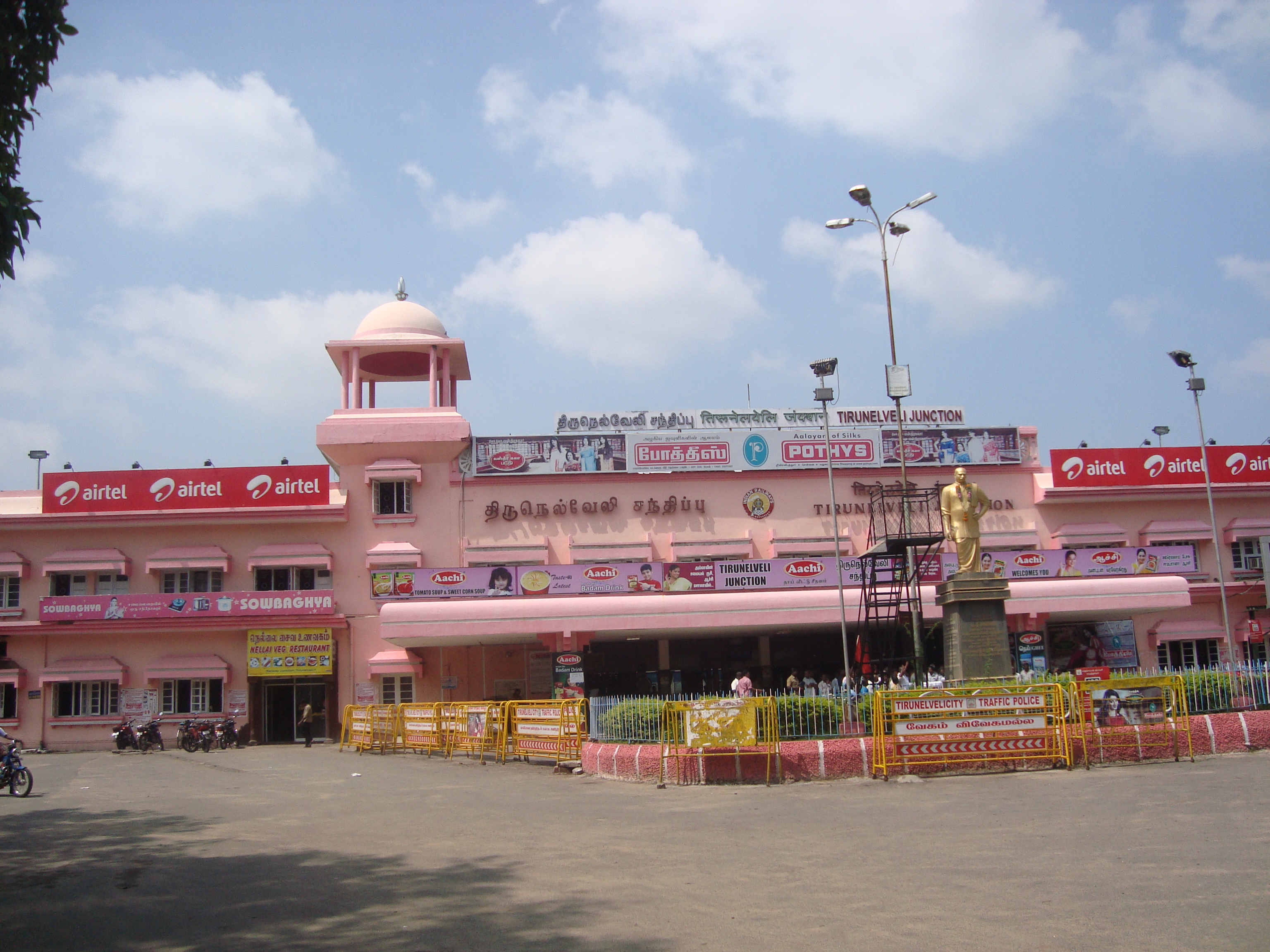
[[File:Tirunelveli Junction.JPG|thumb|upright=0.8|[[Tirunelveli Junction railway station|Tirunelveli Junction]]]] | |||
Tirunelveli Junction railway station is one of the major railway stations in the Madurai division of the [[Southern Railway zone]].<ref>{{cite web |url=https://sr.indianrailways.gov.in/cris//uploads/files/1659695525713-SR.pdf |title=Southern Railway stations |work=[[Indian Railways]] |access-date=12 August 2023 |archive-date=23 December 2023 |archive-url=https://web.archive.org/web/20231223095122/https://sr.indianrailways.gov.in/cris//uploads/files/1659695525713-SR.pdf |url-status=live}}</ref> The line from Tirunelveli to [[Sengottai railway station]] was opened in 1903, and the connection to [[Kollam Junction railway station|Kollam]] was completed later.{{sfn|Hunter|1908|p=373}} The station is connected to [[Vanchi Maniyachchi Junction railway station|Vanchi Maniyachchi Junction]] to the north, [[Nagercoil Junction railway station|Nagercoil Junction]] to the south, [[Tenkasi Junction railway station|Tenkasi Junction]] to the west, and [[Tiruchendur railway station|Tiruchendur]] to the east.<ref>{{cite web |url=https://sr.indianrailways.gov.in/cris//uploads/files/1659677878790-enga4.pdf |title=Route map |work=[[Southern Railway zone]] |access-date=1 June 2025 }}</ref> There are train services connecting the station to various Indian cities from the station.<ref>{{cite web |title= Trains to Tirunelveli |url=http://www.indianrail.gov.in/7days_avlpress_ten.html |work=[[Indian Railways]] |access-date=8 June 2012 }}</ref> | |||
The nearest airport | The nearest airport is the [[Tuticorin Airport]] in [[Thoothukkudi district]], located {{cvt|22|km}} east of the city. The nearest international airports are [[Thiruvananthapuram International Airport]], about {{cvt|130|km}} away and [[Madurai Airport]], {{cvt|150|km}} away from the city.<ref name="About"/> | ||
==Culture== | ==Culture and recreation == | ||
{{see also|Temples of Tirunelveli}} | {{see also|Temples of Tirunelveli}} | ||
Tirunelveli is | Tirunelveli has several Hindu temples, primary of which is the Nellaiappar Temple, dedicated to Shiva.{{sfn|Ayyar|1991|p=498–499}} The temple is mentioned in the verses of ''[[Tevaram]]'', a 7th century work by [[Sambandar]].{{sfn|Soundara Rajan|2001|p=63}} It is one of the ''[[Pancha Sabhai]]'' temples, the five royal courts of [[Nataraja]] (the dancing form of Shiva),{{sfn|Kumar|2001|p=184}} where he performed a cosmic dance.{{sfn|Smith|1996|p=10–48}} The temple was expanded in the 16th century and has a number of sculptures and carved pillars.{{sfn|Soundara Rajan|2001|p=63}} During the annual festival, the [[temple car]] is brought around the streets near the temple.{{sfn|Kumar|2001|p=184}} The city is also home to the [[Uchchhishta Ganapathy Temple]], one of the largest temples dedicated to [[Ganapathi]].<ref>{{cite web |title=Uchishta Ganapathi Temple |url=https://temple.dinamalar.com/en/new_en.php?id=1180 |access-date=1 June 2023 |work=[[Dinamalar]] }}</ref><ref>{{cite web |title=Asia Biggest Vinayagar Temple In Tirunelveli |url=https://news.tirunelveli.today/asia-biggest-vinayagar-temple-in-tirunelveli/ |access-date=1 June 2024 |work=Tirunelveli Today }}</ref> | ||
[[File: | [[File:Tirunelveli halwa.jpg|thumb|upright=0.8|Tirunelveli [[halwa]]]] | ||
Tirunelveli is known for [[halwa]], a sweet made of [[wheat flour]], [[sugar]], and [[ghee]]. It originated during the mid-1800s, and later spread to other places in the region.{{sfn|Davidson|1999|p=378}}<ref>{{cite web |url=http://www.thehindu.com/arts/magazine/article3554551.ece |title=In search of Srivilliputtur Palgova |work=[[The Hindu]] |date=23 June 2012 |access-date=22 December 2012 }}</ref> [[Iruttu Kadai]], a shop opened in the early 20th century, is popular and unique.<ref>{{cite web |url=http://www.hindu.com/2011/04/21/stories/2011042157080500.htm |archive-url=https://web.archive.org/web/20110426175610/http://www.hindu.com/2011/04/21/stories/2011042157080500.htm |url-status=dead |archive-date=26 April 2011 |title=Court says 'no' to use of 'Iruttukadai' |date=21 April 2011|access-date=22 December 2012 |work=[[The Hindu]] }}</ref> | |||
Tirunelveli has a number of cinemas, with the Central theater, opened in 1962, being the largest.<ref>{{cite web |url=https://tamil.news18.com/tirunelveli/nellai-central-theater-is-the-second-largest-theater-in-asia-san-gwi-local18-1686526.html |language=ta |title=Central theater is the second largest in Asia |work=[[News 18]] |access-date=1 June 2025 }}</ref> There are few [[radio stations]] that operate from the city.<ref>{{cite news |url=http://www.thehindubusinessline.in/2003/02/27/stories/2003022701330800.htm |title=Suryan FM gets ready to turn the radios on |work=[[Business Line]] |date=26 February 2003 |access-date=22 December 2012 }}</ref> The Anna stadium is the popular sports venue in the city.<ref>{{cite news |url=http://www.hindu.com/2007/01/10/stories/2007011004360200.htm |archive-url=https://web.archive.org/web/20121112152941/http://www.hindu.com/2007/01/10/stories/2007011004360200.htm |url-status=dead |archive-date=12 November 2012 |title=Anna Stadium to get floodlight facility |date=10 January 2007 |access-date=1 June 2012 |work=[[The Hindu]] }}</ref> The Sports Development Authority of the Government of Tamil Nadu is runs several sporting facilities in the city.<ref>{{cite web |title= 2012–13 Sports Hostel|url=http://www.sdat.in/school_hostel.html |work=Sports Development Authority of Tamil Nadu |access-date=8 June 2012 }}</ref> The Government exhibition is an annual event at the exhibition grounds.<ref>{{cite news |url=http://www.thehindu.com/todays-paper/tp-national/tp-tamilnadu/article3565107.ece |title= Government expo to begin on June 29 |work=[[The Hindu]] |date=24 June 2012 |access-date=29 December 2012 }}</ref> Other places of interest include the nearby [[Manimuthar Dam|Manimuthar]] and [[Papanasam Dam]]s, Ariakulam, [[Koonthankulam Bird Sanctuary]], Manjolai, and Upper Kodaiyar.<ref>{{cite web|title=Tourism in Tirunelveli |url=http://tirunelvelicorp.tn.gov.in/tourism.html |work=[[Government of Tamil Nadu]] |access-date=26 June 2012 }}</ref> | |||
==Education== | ==Education== | ||
[[File:Tirunelveli Medical College2.JPG|thumb| | [[File:Tirunelveli Medical College2.JPG|thumb|upright=0.8|[[Tirunelveli Medical College]]|alt=a building viewed amidst trees]] | ||
During the early 19th century, various schools were established by [[Christian missionaries]].{{sfn|Lewis|2004|p=117}} The first girls school was opened in 1821.{{sfn|Forbes|1996|p=39}}{{sfn|Manohar|2007|p=2}} Later, a two tier school system was introduced by the British Raj, with the district schools, teaching English and sub-district schools, teaching vernacular languages. There were four sub-district schools: two teaching Tamil and one each for [[Telugu language|Telugu]] and [[Persian language|Persian]].{{sfn|Raman|2012|p=102–103}} {{As of|2007}}, the city had 80 schools including 29 higher secondary schools, 12 high schools, 22 middle schools, and 17 primary schools. The city corporation operates 33 of these schools. <ref name="TNUIFSL"/>{{rp|page=22}} As per a report in 2002, the drop in female school attendance between ages 15 and 19 is almost four times greater than that in the rest of Tamil Nadu.{{sfn|Kapadia|2002|p=75}} | |||
[[ | The [[Manonmaniam Sundaranar University]] is located in the city. There are eight arts and science colleges and six professional colleges in the city.<ref name="TNUIFSL"/>{{rp|page=22}} Other major government institutions include [[Tirunelveli Medical College]], Veterinary College and Research Institution, [[Government Law College, Tirunelveli]], and [[Government College of Engineering, Tirunelveli]].<ref>{{cite web |title=Nellai Medical College |url=http://www.nellaimedicos.com/ |work=Nellai Medical College |access-date=29 December 2012 }}</ref><ref>{{cite web|title=Veterinary College |url=http://www.tanuvas.ac.in/vcritnl.html |work=amil Nadu Veterinary and Animal Sciences University |access-date=29 December 2012 }}</ref><ref>{{cite web |title=Government College of Engineering, Tirunelveli |url=http://www.gcetirunelveli.com/ |archive-url=https://web.archive.org/web/20050301024428/http://www.gcetirunelveli.com/|url-status=usurped|archive-date=1 March 2005 |work=Government College of Engineering, Tirunelveli |access-date=29 December 2012 }}</ref> The [[Sarah Tucker College]], established in 1895, was the first women's college in the state.<ref>{{cite web |url=https://www.thehindu.com/features/metroplus/madrass-first-womens-college/article5617593.ece |title=First Women's Colleges in India |date=26 January 2014 |access-date=28 January 2023 |work=[[The Hindu]] |archive-date=1 April 2019 |archive-url=https://web.archive.org/web/20190401215117/https://www.thehindu.com/features/metroplus/madrass-first-womens-college/article5617593.ece}}</ref> The Indian Institute of Geomagnetism operates the Equatorial Geophysical Research Laboratory in the city.<ref>{{cite web |title=Equatorial Geophysical Research Laboratory, Tirunelveli |url=http://iigm.res.in/iigweb/index.php/133 |work=Indian Institute of Geomagenetism |access-date = 26 June 2012 }}</ref> The city has a [[District Science Center - Tirunelveli|District Science Center]] with permanent exhibitions, science shows, interactive tours, a mini-[[planetarium]] and sky observation deck.<ref>{{cite news |url=http://www.hindu.com/2007/01/17/stories/2007011716060300.htm |archive-url=https://web.archive.org/web/20071001023615/http://www.hindu.com/2007/01/17/stories/2007011716060300.htm |url-status=dead |archive-date=1 October 2007 |title=Fun science gallery inaugurated in Tirunelveli|date=17 January 2007|access-date=17 January 2007|work=[[The Hindu]] }}</ref><ref>{{cite web |url=http://www.vismuseum.org.in/units.html |title=Visvesvaraya Industrial & Technological Museum : Satellite Units |access-date=14 October 2008 }}</ref> | ||
The Indian | =={{anchor|Utility services}}Utility services== | ||
Electricity is regulated and distributed by the [[Tamil Nadu Electricity Board]]. The city is headquarters for the Tirunelveli Electricity Distribution Circle.<ref>{{cite web |title=Tamil Nadu Electricity Board |url=http://www.windpro.org/pdf/MISC/TNEB%20Address.pdf |work=Indian Wind Power Association |access-date=18 December 2011 |url-status=dead|archive-url=https://web.archive.org/web/20121016045943/http://www.windpro.org/pdf/MISC/TNEB%20Address.pdf |archive-date=16 October 2012 }}</ref> Water supply is provided by the city corporation, and is derived from the Tamirabarani river, throughout the city.<ref name="TNUIFSL"/>{{rp|page=17}}<ref>{{cite web |title=Water Supply Details |url=http://tirunelvelicorp.tn.gov.in/water.html |work=[[Tirunelveli Municipal Corporation]] |access-date=26 June 2012 }}</ref> {{As of|2011}}, about 100 metric tonnes of solid waste were collected from the city in door-to-door collection, after which source segregation and disposal is performed by the sanitary department of the corporation.<ref>{{cite web |title=Waste management programme |url=http://tirunelvelicorp.tn.gov.in/waste.html |work=[[Tirunelveli Municipal Corporation]] |access-date=26 June 2012 }}</ref> The underground drainage system was constituted in 1998, and covers part of the city. The remaining system for disposal of sewage is through septic tanks and public conveniences.<ref name="TNUIFSL"/>{{rp|page=18}}<ref>{{cite web |title=Tirunelveli sewarage |url=http://tirunelvelicorp.tn.gov.in/sewerage.html |work=[[Tirunelveli Municipal Corporation]] |access-date=26 June 2012 }}</ref> The corporation maintains about {{cvt|184.8|km}} of stormwater drains.<ref name="TNUIFSL"/>{{rp|page=18}} The government operates hospitals and primary health care centers, and conducts family-welfare and immunisation programs.<ref name="TNUIFSL"/>{{rp|page=21}} In addition, there are several private hospitals and clinics providing health care to citizens.<ref>{{cite web |title=Tirunelveli hospitals|url=http://tirunelvelicorp.tn.gov.in/hospitals.html |work=[[Tirunelveli Municipal Corporation]] |access-date=26 June 2012 }}</ref> | |||
Tirunelveli | Tirunelveli is part of the Tirunelveli telecom district of [[Bharat Sanchar Nigam Limited]], India's state-owned telecom and internet-services provider, which provides fixed line, and [[broadband internet]] services.<ref>{{cite web |title=List of cities where BSNL broadband service is available (As on 01.01.2007) |url=http://www.bsnl.co.in/service/broadband_list_of_cities.pdf |access-date=20 May 2011 |work=[[Bharat Sanchar Nigam Limited]] |url-status=dead |archive-url=https://web.archive.org/web/20070204070855/http://www.bsnl.co.in/service/broadband_list_of_cities.pdf |archive-date=4 February 2007 }}</ref><ref>{{cite web |title=List of cities where Calling Line Identification Based Internet Service is available |url=http://www.bsnl.co.in/service/cities_cli.htm |work=[[Bharat Sanchar Nigam Limited]] |access-date=19 May 2011 |url-status=dead |archive-url=https://web.archive.org/web/20120308094431/http://www.bsnl.co.in/service/cities_cli.htm |archive-date=8 March 2012 }}</ref> The city has a Passport Seva Kendra, which accepts passport applications from the Tirunelveli region for processing at the passport office in Madurai.<ref>{{cite news |url=http://www.thehindu.com/todays-paper/tp-national/tp-tamilnadu/six-lakh-passports-issued-in-five-years/article4177360.ece |title=Six lakh passports issued in five years |work=[[The Hindu]] |date=8 December 2012 |access-date=17 January 2007 }}</ref> | ||
== | ==Notes== | ||
{{notelist}} | |||
==References== | |||
{{Reflist}} | {{Reflist}} | ||
== | ===Bibliography=== | ||
{{refbegin | {{refbegin}} | ||
* {{cite | * {{cite book |last=Ayyar |first=P. V. Jagadisa |title=South Indian shrines: illustrated |year=1982 |publisher=[[Asian Educational Services]] |location=New Delhi |isbn=978-8-120-60151-2 |url=https://books.google.com/books?id=NLSGFW1uZboC }} | ||
* {{ | * {{cite book |url=https://books.google.com/books?id=zjTneAGmatsC |title=The History of Tinnevelly From The Earliest Period to the Cession to the English Government in 1801 |last=Caldwell |first= Robert |author-link=Robert Caldwell |edition=Reprinted |publisher=[[Asian Educational Services]] |year=1982 |orig-year=1881 |isbn=978-8-120-60161-1 |access-date=29 December 2012 }} | ||
* {{cite | * {{cite report |url=http://www.arts.ualberta.ca/axismundi/2004/Hinduisms.pdf |title=Hinduisms, Christian Missions, and the Tinnevelly Shanars: A Study of Colonial Missions in 19th Century India |last=Daughrity |first=Dyron B. |year=2005 |pages=1–5 |publisher=[[University of Calgary]] |location=Alberta |access-date=29 December 2012}} | ||
* {{cite | * {{cite report |url=http://www.missionstudies.org/conference/1papers/fp/Dyron_Daughrity_Tirunelveli.pdf |archive-url=https://web.archive.org/web/20070928093035/http://www.missionstudies.org/conference/1papers/fp/Dyron_Daughrity_Tirunelveli.pdf |archive-date=28 September 2007 |title=A Brief History of Missions in Tirunelveli1 (Part One): From the Beginnings to its Creation as a Diocese in 1896 |last=Daughrity |first=Dyron B. |publisher=Mission Studies |access-date=29 December 2012 |year=2007 |url-status=dead }} | ||
* {{cite book | | * {{cite book |first=Alan |last=Davidson |author-link=Alan Davidson (food writer) |title=The Oxford Companion to Food |publisher=[[Oxford University press]] |year=1999 |location=Oxford |url=https://books.google.com/books?id=bIIeBQAAQBAJ |isbn=978-0-192-11579-9 }} | ||
* {{cite book | | * {{cite book |url=https://books.google.com/books?id=hjilIrVt9hUC |title=Women in Modern India, Volume 4 |last=Forbes |first=Geraldine |publisher=[[Cambridge University Press]] |year=1996 |isbn=978-0-521-65377-0 }} | ||
* {{cite book|last= | * {{cite book |last=Harman |first=William P. |title=The sacred marriage of a Hindu goddess |year=1992 |publisher=[[Motilal Banarsidass]] |isbn=978-81-208-0810-2 |url=https://books.google.com/books?id=F_siW9T3ev4C }} | ||
* {{cite book |url=https:// | * {{cite book |last=Hunter |first=William Wilson |title=Imperial Gazetteer of India Vol. XXII Singbhum to Trashi-Chod-Zong |year=1908 |publisher=[[Clarendon Press]] |location=Oxford |url=https://books.google.com/books?id=635DAAAAYAAJ }} | ||
* {{ | * {{cite book |title=Human rights violation |last=Kanmony |first=Jebagnanam Cyril |url=https://books.google.com/books?id=NE5UKHOFVGYC |year=2010 |publisher=Mittal Publications |isbn=978-8-183-24347-6 }} | ||
* {{cite book |url=https://books.google.com/books?id= | * {{cite book |title=Scheduled Caste Welfare |url=https://books.google.com/books?id=hjGudU7RVwcC |first=P. |last=Kannappan |year=2008 |publisher=APH Publishing Corporation |location=New Delhi |isbn=978-8-131-30370-2}} | ||
* {{cite book | | * {{cite book |url=https://books.google.com/books?id=GG06ImmHy1oC |title=The Violence of Development: The Political Economy of Gender |last=Kapadia |first=Karin |publisher=[[Palgrave Macmillan]] |year=2002 |isbn=978-1-842-77207-2}} | ||
* {{cite book |url=https://books.google.com/books?id= | * {{cite book |url=https://books.google.com/books?id=-BcUujyJpKEC |title=Essays on Indian Economy |last=Kumar |first=Raj |publisher=Discovery Publishing House |year=2003 |isbn=978-8-171-41700-1 }} | ||
* {{ | * {{cite book |last=Kumar |first=Sehdev |title= A thousand petalled lotus: Jain temples of Rajasthan : architecture & iconography |year=2001 |publisher=Indra Gandhi National Centre of Arts |location=New Delhi |isbn=978-8-170-17348-9}} | ||
* {{cite book |url=https://books.google.com/books?id= | * {{cite book |url=https://books.google.com/books?id=boYncPEOJwcC&q=tirunelveli+schools&pg=PA121 |title=Christianity Reborn: The Global Expansion of Evangelicalism in the Twentieth Century |last=Lewis |first=Donald M. |publisher=Eerdmans Publishing |year=2004 |isbn=978-0-802-82483-7 }} | ||
* {{cite book |url=https://books.google.com/books?id= | * {{cite book |url=https://books.google.com/books?id=CBNMY34zknIC |title=Indian English Women's Fiction: A Study of Marriage, Career And Divorce |last=Manohar |first=Murali |publisher=Atlantic Publishers |year=2007 |isbn=978-81-269-0683-3 }} | ||
* {{cite book | | * {{cite book |url=https://books.google.com/books?id=WW67K09byR4C |title=Document Raj: Writing and Scribes in Early Colonial South India|last= Raman |first=Bhavani |publisher=[[University of Chicago Press]] |location=Chicago |year=2012 |isbn=978-0-226-70329-9 }} | ||
* {{cite book| | * {{cite book |url=https://books.google.com/books?id=ISFBJarYX7YC |title=Britannica India: Volumes 1-5 |last=Ramchandani |first=Indu |publisher=[[Britannica]] |location=New Delhi |year=2000 |isbn=978-0-852-29760-5 }} | ||
* {{cite book |title=Alayam – The Hindu temple – An epitome of Hindu Culture |publisher=[[Ramakrishna Math]] |year=2013 |location=Chennai |last=Reddy |first=Venkatramana |isbn=978-8-178-23542-4}} | |||
* {{cite book | | * {{cite book |first=Farooqui |last=Salma Ahmed |title=A Comprehensive History of Medieval India: From Twelfth to the Mid Eighteenth century |publisher=[[Dorling Kindersley]] |location=New Delhi |isbn=978-8-131-73202-1 |year=2011}} | ||
* {{cite book|title= | * {{cite book |last=Smith |first=David| title=The Dance of Siva: Religion, Art and Poetry in South India By David |year=1996 |publisher=[[University of Cambridge]] |isbn=978-0-521-48234-9 |url-access=registration |url=https://archive.org/details/danceofsivarelig0000smit }} | ||
* {{cite book| | * {{cite book |last=Soundarapandian |first=Mookkiah |title=Small Scale Industries, Volume 1 |year=2002|publisher=Concept Publishing Company |location=New Delhi |isbn=978-8-170-22990-2|url=https://books.google.com/books?id=TojZelczVxAC}} | ||
* {{cite book |last=Soundara Rajan |first=Kodayanallur Vanamamalai |title=Concise classified dictionary of Hinduism |year=2001 |publisher=Concept Publishing Company |location=New Delhi |isbn=978-8-170-22857-8|url=https://books.google.com/books?id=lAWS49f8HKoC }} | |||
* {{ | * {{cite book |url=https://books.google.com/books?id=OpxeaYQbGDMC&q=tirunelveli+economy&pg=PA79 |title=New Cambridge History of India |last1=Stein |first1=Burton |first2=Gordon |last2=Johnson |first3=Christopher |last3= Bayly |first4=John F. |last4=Richards |publisher=[[Cambridge University Press]] |location=New York |year=1990 |isbn=978-0-521-26693-2 }} | ||
* {{cite book |last=Stein |first=A.J. |url=https://archive.org/details/dli.ministry.16838/page/1/mode/2up |title=A Manual of the Tinnevelly district in the presidency of Madras |year=1879 |publisher=Government Press |location=Madras }} | |||
* {{cite book |url=https://books.google.com/books?id=jgSMPKVh7f8C |title=The Political Economy of Commerce: Southern India 1500–1650 |last=Subrahmanyam |first=Sanjay |publisher=[[Cambridge University Press]] |location=New York |year=2002 |isbn=978-0-521-89226-1 }} | |||
* {{cite book|title=Gazetteer of South India, Volume 1|last=Francis |first=W. |url=https://books.google.com/books?id=vERnljM1uiEC |publisher=Mittal Publications |year=2002 }} | |||
{{refend}} | {{refend}} | ||
==External links== | ==External links== | ||
{{wikivoyage|Tirunelveli}} | |||
{{Commons category}} | |||
* [https://web.archive.org/web/20080110191554/http://tirunelvelicorp.tn.gov.in/ Tirunelveli City-Municipal Corporation] | * [https://web.archive.org/web/20080110191554/http://tirunelvelicorp.tn.gov.in/ Tirunelveli City-Municipal Corporation] | ||
Latest revision as of 15:28, 11 March 2026
Tirunelveli | |
|---|---|
| Nickname: | |
  Tirunelveli Tirunelveli, Tamil Nadu  Tirunelveli Tirunelveli (India) | |
| Coordinates: 8°42′49″N 77°45′24″E / 8.71361°N 77.75667°E | |
| Country | India |
| State | Tamil Nadu |
| Region | Pandya Nadu |
| District | Tirunelveli |
| Government | |
| • Type | Municipal Corporation |
| • Body | Tirunelveli City Municipal Corporation |
| Area | |
| • City | 189.9 km2 (73.3 sq mi) |
| • Rank | 3 |
| Elevation | 73 m (240 ft) |
| Population (2011)[3] | |
| • City | 473,637 |
| • Rank | 7th in Tamil Nadu |
| • Density | 2,500/km2 (6,500/sq mi) |
| • Metro | 498,924 |
| Demonym(s) | Tirunelvelian, Nellaikaran |
| Languages | |
| • Official | English, Tamil |
| Time zone | UTC+5:30 (IST) |
| Pin Codes | 627xx |
| Telephone code | 91 (0)462 |
| Vehicle registration | TN 72 |
| Website | tirunelveli |


Tirunelveli (ta),[lower-alpha 1] also known as Nellai, is a city and municipal corporation in the Indian state of Tamil Nadu. It is located on the southern part of the state, on the west bank of the Thamirabarani River. It is the administrative headquarters of the Tirunelveli District. As per the 2011 census, it had a population of 473,637 individuals, and was the seventh-largest city in the state by population.
Tirunelveli has a recorded history dating back to more than two thousand years. It served as a major town during the reign of the Early Pandyas in the Sangam period (3rd century BCE to 3rd century CE). It came under the rule of the Cholas in the 11th century CE. The region was ruled by the Later Pandyas, the Vijayanagara Empire, and the Madurai Nayaks in the late Middle Ages. It came under the influence of the British East India Company in the late 18th century, and the Tinnevelly district was formed on 1 September 1790. In the Polygar War, Palaiyakkarars led by Veerapandiya Kattabomman fought the forces of the Company, on the outskirts of the city from 1797 to 1801. It came under the British Raj in the 19th century, and later became part of the Madras Province of Independent India in 1947.
Tirunelveli is administered by the Tirunelveli Municipal Corporation, which was established on 1 June 1994. The city covers an area of 189.9 km2 (73.3 sq mi). It is well-connected by road and rail with the rest of the state. The economy of the city is dependent on agriculture and its allied industries, services including education, and information technology, manufacturing including tobacco products, cement, and bricks, and textiles. There are several wind power generation farms located in the outskirts of the city. The city serves an educational hub of the region, and is home to several institutions.
Tirunelveli has a number of historical monuments, with the Nellaiappar Temple being the most prominent. The city is renowned for the sweet of 'Irutu kadai halva'.
Etymology[edit | edit source]
The inscriptions at the Nellaiappar Temple mention that Shiva (as Vrihivriteswara) descended to the Earth and took the form of a hedge to save the paddy crop of a devotee. As per the earlier practice of naming settlements based on the vegetation prevalent in the areas of worship,[4] the place was known as 'Venu vanam' (bamboo forest) due to the presence of bamboo where the deity is believed to have appeared.[5] Derived from the story in the Hindu mythology, 'Tirunelveli' is a combination of three Tamil words–'thiru', 'nel', and 'veli', meaning sacred, paddy, and hedge respectively.[6][7] The seventh-century Saiva canonical work Tevaram mentions the town as 'Thirunelveli'.[8] The town was called Tirunelveli Seemai during the late Middle Ages, with 'seemai' meaning town in Tamil. It was anglicised as 'Tinnelvelly' during the British Raj, and was officially named Tirunelveli after the Indian independence.[7][9]
History[edit | edit source]
Tirunelveli was part of the Pandian Empire, references to which are present in the Sangam literature, and inscriptions dating back to the 3rd century BCE.[10] The region came under the rule of the Cholas in the 11th century CE.[11] It remained under the control of the Cholas until the early 13th century CE, when the Pandyas re-established control over the region, and ruled with Madurai as the capital.[12] During the 13th and 14th centuries, Tirunelveli was the secondary capital of Pandimandalam, the country ruled by the Pandyas.[13]

The Nellaiappar temple was the royal shrine of the later Pandyas, and the city benefited from extensive irrigation facilities were developed based on the Thamirabarani River. The Vijayanagara Empire occupied the region in the 15th century CE. During the Vijayanagara rule, Brahmin and Vellalar chieftains held rights over community lands ('kani') in the Thamirabarani valley, while Maravar and Shanar migrants settled around the region. The Maravars populated the western foothills, the Kannadigas and Telugus settled on the eastern dry tracts of land.[13] In the 16th century CE, the region was ruled by the Madurai Nayaks, and Tirunelveli served as the subsidiary capital of the Nayak territory.[14] The city was rebuilt extensively during the reign of Viswanatha Nayak (1529–64), who also developed several temples in the region.[15]
The region briefly came under the control of Nawabs of Arcot after they defeated the Marathas in 1743 CE. However, during the time, the palaiyakkarars, who were originally military governors under the Nayak rule, held control over the lands. In the middle of the 18th century, the British East India Company began to establish control over the lands in the region.[16][17] Between the 15th and 18th centuries, Tirunelveli became a major economic center in the region, with migration of people to the city.[18] During the 18th century, the town was often called as Nellai Cheemai, with 'Cheemai' meaning 'foreign town'.[19]
.jpg)
Though the British restored some order in 1755 CE, the palaiyakkarars, who had built massive forts, and held their own armies, continued to fight with the British, and within themselves. Briefly, the British had it troops in the region, while the palaiyakkarars managed the territory on behalf of the Nawabs.[16] However, the palaiyakkarars later continued to engage in skirmishes with the British. This culminated in the Polygar Wars, in which a group of palaiyakkarars, led by Veerapandiya Kattabomman, fought against the British, who were also aided by some of the palaiyakkarars. Kattabomman was defeated and hanged, and eventually the region came under the complete control of the British in 1801 CE.[20][21][16]
Tinnevelly district was established on 1 September 1790, with Tinnevelly serving as the headquarters of the district.[22] The history of Tirunelveli was extensively researched and documented by Robert Caldwell (1814–91), a Christian missionary who visited the area in the early 19th century CE.[23][24] Palayamkottai, which housed the old fort built by the palaiyakkarars, served as a garrison.[25] Tirunelveli was part of the Madras Presidency during the British Raj.[26] After Indian independence, it became part of the Madras Province, which later became the Madras State in 1950, and Tamil Nadu in 1969.[27]
Geography[edit | edit source]

Tirunelveli is situated in the southern tip of the Indian peninsula.[26] It is located on the west bank of the Tamirabarani river, with Palayamkottai located on the other side.[28] The river is the major water source of the city, and is fed by the monsoons.[29] There are several small lakes and ponds in the city.[30]
Geology and vegetation[edit | edit source]

The region is composed mainly of gneiss rocks, and consists of red sand, accumulated by the effect of wind blowing from theAgasthiyamalai hills to the east. There is a thin strip of alluvial soil along the banks of the Tamirabarani river, and stretches of black soil to the north, which support paddy and cotton respectively.[31][32] Pineapples, chili, and tobacco were introduced during the late 16th century and potatoes during the early 17th century.[33] The most common tree is the palm, with other trees in the region include bamboo, teak, kadambu, vengai, pillai maruthu, kari maruthu, and jack fruit.[34]
Climate[edit | edit source]
Tirunelveli has a equable climate with less rainfall, and influenced by both northeast and southwest monsoon.[35][31] The Agasthiyamalai hills, which is part of the Western Ghats, lie to the west of the town, and blocks the southwest monsoon winds, causing a rainshadow region to the east.[36] The mean maximum temperature during summer (March to June) averages 35 °C (95 °F), and touches 38 °C (100 °F) during the hottest period in May. In the winter (December to January), the temperature rarely drops below 25 °C (77 °F), with an average minimum of 22 °C (72 °F) during the coldest days. The southwest monsoon brings cool winds, and mild rainfall in the second part of June, with maximum precipitation occurs during the northeast monsoon (October–December). The average annual rainfall is 890 mm (35 in).[35][31]
| Climate data for Palayamkottai, 1991–2020, extremes 1947–present | |||||||||||||
|---|---|---|---|---|---|---|---|---|---|---|---|---|---|
| Month | Jan | Feb | Mar | Apr | May | Jun | Jul | Aug | Sep | Oct | Nov | Dec | Year |
| Record high °C (°F) | 36.0 (96.8) |
39.0 (102.2) |
41.7 (107.1) |
42.0 (107.6) |
42.8 (109.0) |
44.9 (112.8) |
41.9 (107.4) |
40.4 (104.7) |
40.5 (104.9) |
41.0 (105.8) |
38.9 (102.0) |
37.0 (98.6) |
44.9 (112.8) |
| Average high °C (°F) | 31.5 (88.7) |
33.4 (92.1) |
35.3 (95.5) |
36.3 (97.3) |
37.5 (99.5) |
36.1 (97.0) |
34.8 (94.6) |
35.0 (95.0) |
35.6 (96.1) |
33.6 (92.5) |
30.9 (87.6) |
30.3 (86.5) |
34.1 (93.4) |
| Average low °C (°F) | 22.5 (72.5) |
23.1 (73.6) |
24.0 (75.2) |
25.6 (78.1) |
26.3 (79.3) |
26.4 (79.5) |
26.2 (79.2) |
25.9 (78.6) |
25.6 (78.1) |
24.7 (76.5) |
23.7 (74.7) |
22.8 (73.0) |
24.7 (76.5) |
| Record low °C (°F) | 18.0 (64.4) |
18.0 (64.4) |
18.4 (65.1) |
20.3 (68.5) |
16.3 (61.3) |
20.4 (68.7) |
19.3 (66.7) |
21.6 (70.9) |
19.5 (67.1) |
17.9 (64.2) |
16.9 (62.4) |
17.6 (63.7) |
16.9 (62.4) |
| Average rainfall mm (inches) | 14.0 (0.55) |
19.3 (0.76) |
31.9 (1.26) |
64.7 (2.55) |
56.2 (2.21) |
9.9 (0.39) |
11.9 (0.47) |
34.5 (1.36) |
45.1 (1.78) |
161.4 (6.35) |
217.0 (8.54) |
96.2 (3.79) |
762.0 (30.00) |
| Average rainy days | 1.7 | 1.4 | 2.1 | 3.6 | 3.0 | 1.2 | 0.9 | 1.9 | 3.0 | 7.7 | 10.6 | 5.6 | 42.7 |
| Average relative humidity (%) (at 17:30 IST) | 64 | 57 | 54 | 58 | 55 | 55 | 55 | 55 | 53 | 63 | 72 | 69 | 59 |
| Source: India Meteorological Department[37][38][39] | |||||||||||||
Demographics[edit | edit source]
According to 2011 census, Tirunelveli had a population of 473,637 individuals.[40] The sex ratio was 1,027 females for every 1,000 males, much above the national average of 929. About 42,756 inhabitants were under the age of six. Scheduled Castes and Scheduled Tribes accounted for 13.17% and 0.32% of the population respectively. The average literacy was rate was 90.4% with a male literacy of 94.8% and female literacy 86.2%. The city had 120,466 households, and about 14.4% of the population resided in slums. There were a total of 182,471 workers, comprising 2,088 cultivators, 5,515 main agricultural labourers, 18,914 in house hold industries, 142,435 other workers, 13,519 marginal workers, 166 marginal cultivators, 913 marginal agricultural labourers, 1,828 marginal workers in household industries and 10,612 other marginal workers.[41][42]
The city covers an area of 108.65 km2 (41.95 sq mi). The population density of the city was 3,781 persons per square kilometre in 2001, compared with 2,218 persons per square kilometre in 1971.[43] According to provisional data from the 2011 census the Tirunelveli urban agglomeration had a population of 498,984 inhabitants, including 246,710 males and 252,274 females.[44] As per the religious census of 2011, Hinduism was the predominant religion with 69% of the population adhering to it. Islam (20%) and Christianity (10.6%) formed significant minority of the population.[45]
Tamil is the main language spoken in the city, with the use of English common in educational institutions and offices in the service sector. The Tamil dialect spoken in this region is distinct, and is widely spoken throughout the region.[46]
Administration and politics[edit | edit source]
| Administration | ||
|---|---|---|
| Mayor | G. Ramakrishnan[47] | |
| Corporation Commissioner | Monika Rana[47] | |
| Commissioner of Police | Prassanna Kumar[47] | |
| Member of Parliament | ||
| Tirunelveli | C. Robert Bruce[48] | |
| Members of Legislative Assembly | ||
| Tirunelveli | Nainar Nagendran[49] | |
| Palayamkottai | M. Abdul Wahab[49] | |
The Tirunelveli Municipality was established in 1866.[15] It became a Municipal Corporation in 1994, by combining the Palayamkottai and Melapalayam municipalities, the Thachanallur town panchayat and eleven other village panchayats with the city. The municipal corporation has 55 wards divided across four zones–Melapalayam, Palayamkottai, Thatchanallur, and Tirunelveli.[50](p15)[51] Each ward is represented by a councilor, who form part of the municipal council headed by a mayor.[52] The administrative functions of the corporation are managed by a corporation commissioner. The corporation has six departments: general administration and personnel, engineering, revenue, public health, city planning and information technology.[53]
Tirunelveli is part of the Tirunelveli and Palayamkottai assembly constituencies, which elect a member each to the Tamil Nadu Legislative Assembly every five years.[54] The city is a part of the Tirunelveli Lok Sabha constituency.[55] The All India Anna Dravida Munnetra Kazhagam has won the seat seven times, in 1977,[56] three times consecutively from 1984 to 1991,[57][58][59] 1998,[60] and 1999,[61] and 2014.[62] The Indian National Congress has won the seat five times in 1957,[63] 1962,[64] 2004,[65] 2009,[66] and 2024.[48] The Dravida Munnetra Kazhagam has won it thrice, in 1980,[67] 1996,[68] and 2019,[66] and the Swantantra Party and Communist Party of India once each.[69][70]
Law and order in the city is maintained by the Tirunelveli city division of the Tamil Nadu Police, headed by a Police commissioner. There are various units for prohibition enforcement, district crime, social justice and human rights, district crime records and a special branch operating at the district level, each headed by a Deputy Superintendent of Police.[71]
Economy[edit | edit source]
Tirunelveli is located in a strategic location, at the southern tip of the Indian mainland, connecting the eastern and western parts of the peninsula. Records indicate sea and overland trade in the 18th and 19th centuries with the western coast of India, and Sri Lanka.[72] During the 1840s, cotton production flourished in the region, and was exported to Britain.[73] Other exports included jaggery, chillies, tobacco, palmyra fiber, salt, dried saltwater fish, and cattle.[74]
Agriculture is a major contributor to the economy and the major produces in the region include rice and cotton.[75] Food-processing industries have developed since the late 1990s.[76] Other industries include rice mills, and blue metal manufacturing, located on the outskirts of the city.[77] Beedi production is a major industry, and is a significant contributor to exports from the town.[78] The region has significant limestone deposits, which has resulted in the development of cement industry.[79](p6) Other small scale industries include handloom, mat and basket weaving, palmyrah products, poultry, brick kilns, tiles making, carpentry, metal works, terracotta, and lacquerware.[79](p19) In 1991, the Tirunelveli district ranked second in the state in the number of women workers.[80]
The Tirunelveli Industrial Estate was established in 1959 by the Government of Tamil Nadu.[79](p11) An information technology park is located in Gangaikondan, about 20 km (12 mi) north of the city.[79](p12) An industrial Special Economic Zone, is located 30 km (19 mi) from the city, and houses various textile, calcite production, and bottled oxygen manufacturing units.[79](p14) The region is a major area for wind power generation, with various wind mills located on the outskirts of city.[81]
Transport[edit | edit source]

Tirunelveli has an extensive road network. As of 2025[update], the corporation maintains about 933.32 km (579.94 mi) of roads including 687.76 km (427.35 mi) of paved roads, and 242.73 km (150.83 mi) of concrete roads.[82] The National Highway 44 (old NH 7) and National Highway 82 pass through the city.[83][84] Several State Highways connect the city to nearby towns such as Sankarankovil, Thoothukudi, and Tiruchendur.[85][50](p19) There are two bridges across the Tamirabarani river in the city. The Sulochana Mudaliar bridge was constructed in the 1840s, and connects Tirunelveli wit Palayamkottai. The Thiruvalluvar bridge was opened in 1972, and is situated near the Tirunelveli Junction railway station.[86][87]
The main bus stand, Dr. MGR Bus Stand, opened in 2003, is located in Veinthaankulam. The bus stand was further renovated and opened in December 2021.[88][89] Intra city bus stations are located at railway junction and Palay. The Tamil Nadu State Transport Corporation and the State Express Transport Corporation operate intercity bus services.[46][90]

Tirunelveli Junction railway station is one of the major railway stations in the Madurai division of the Southern Railway zone.[91] The line from Tirunelveli to Sengottai railway station was opened in 1903, and the connection to Kollam was completed later.[92] The station is connected to Vanchi Maniyachchi Junction to the north, Nagercoil Junction to the south, Tenkasi Junction to the west, and Tiruchendur to the east.[93] There are train services connecting the station to various Indian cities from the station.[94]
The nearest airport is the Tuticorin Airport in Thoothukkudi district, located 22 km (14 mi) east of the city. The nearest international airports are Thiruvananthapuram International Airport, about 130 km (81 mi) away and Madurai Airport, 150 km (93 mi) away from the city.[46]
Culture and recreation[edit | edit source]
Tirunelveli has several Hindu temples, primary of which is the Nellaiappar Temple, dedicated to Shiva.[95] The temple is mentioned in the verses of Tevaram, a 7th century work by Sambandar.[96] It is one of the Pancha Sabhai temples, the five royal courts of Nataraja (the dancing form of Shiva),[97] where he performed a cosmic dance.[98] The temple was expanded in the 16th century and has a number of sculptures and carved pillars.[96] During the annual festival, the temple car is brought around the streets near the temple.[97] The city is also home to the Uchchhishta Ganapathy Temple, one of the largest temples dedicated to Ganapathi.[99][100]

Tirunelveli is known for halwa, a sweet made of wheat flour, sugar, and ghee. It originated during the mid-1800s, and later spread to other places in the region.[101][102] Iruttu Kadai, a shop opened in the early 20th century, is popular and unique.[103]
Tirunelveli has a number of cinemas, with the Central theater, opened in 1962, being the largest.[104] There are few radio stations that operate from the city.[105] The Anna stadium is the popular sports venue in the city.[106] The Sports Development Authority of the Government of Tamil Nadu is runs several sporting facilities in the city.[107] The Government exhibition is an annual event at the exhibition grounds.[108] Other places of interest include the nearby Manimuthar and Papanasam Dams, Ariakulam, Koonthankulam Bird Sanctuary, Manjolai, and Upper Kodaiyar.[109]
Education[edit | edit source]

During the early 19th century, various schools were established by Christian missionaries.[110] The first girls school was opened in 1821.[111][112] Later, a two tier school system was introduced by the British Raj, with the district schools, teaching English and sub-district schools, teaching vernacular languages. There were four sub-district schools: two teaching Tamil and one each for Telugu and Persian.[113] As of 2007[update], the city had 80 schools including 29 higher secondary schools, 12 high schools, 22 middle schools, and 17 primary schools. The city corporation operates 33 of these schools. [50](p22) As per a report in 2002, the drop in female school attendance between ages 15 and 19 is almost four times greater than that in the rest of Tamil Nadu.[114]
The Manonmaniam Sundaranar University is located in the city. There are eight arts and science colleges and six professional colleges in the city.[50](p22) Other major government institutions include Tirunelveli Medical College, Veterinary College and Research Institution, Government Law College, Tirunelveli, and Government College of Engineering, Tirunelveli.[115][116][117] The Sarah Tucker College, established in 1895, was the first women's college in the state.[118] The Indian Institute of Geomagnetism operates the Equatorial Geophysical Research Laboratory in the city.[119] The city has a District Science Center with permanent exhibitions, science shows, interactive tours, a mini-planetarium and sky observation deck.[120][121]
Utility services[edit | edit source]
Electricity is regulated and distributed by the Tamil Nadu Electricity Board. The city is headquarters for the Tirunelveli Electricity Distribution Circle.[122] Water supply is provided by the city corporation, and is derived from the Tamirabarani river, throughout the city.[50](p17)[123] As of 2011[update], about 100 metric tonnes of solid waste were collected from the city in door-to-door collection, after which source segregation and disposal is performed by the sanitary department of the corporation.[124] The underground drainage system was constituted in 1998, and covers part of the city. The remaining system for disposal of sewage is through septic tanks and public conveniences.[50](p18)[125] The corporation maintains about 184.8 km (114.8 mi) of stormwater drains.[50](p18) The government operates hospitals and primary health care centers, and conducts family-welfare and immunisation programs.[50](p21) In addition, there are several private hospitals and clinics providing health care to citizens.[126]
Tirunelveli is part of the Tirunelveli telecom district of Bharat Sanchar Nigam Limited, India's state-owned telecom and internet-services provider, which provides fixed line, and broadband internet services.[127][128] The city has a Passport Seva Kendra, which accepts passport applications from the Tirunelveli region for processing at the passport office in Madurai.[129]
Notes[edit | edit source]
- ↑ Anglicised as Tinnevelly during the British Raj
References[edit | edit source]
- ↑ Sudhakar, P (19 May 2016). "Palayamkottai electorate earn a dubious distinction". The Hindu. ISSN 0971-751X. Retrieved 14 September 2024.
- ↑ Mallady, Shastry V (10 September 2012). "A case for Madurai". The Hindu. ISSN 0971-751X. Retrieved 14 September 2024.
- ↑ "Census 2011". The Registrar General & Census Commissioner, India. The Registrar General & Census Commissioner, India. Retrieved 20 April 2024.
- ↑ Reddy 2013, p. 10.
- ↑ Ayyar 1982, p. 498–499.
- ↑ Kannappan 2008, p. 67.
- ↑ 7.0 7.1 Caldwell 1990, p. 88.
- ↑ Sambandar. "Moondram Thirumurai". Thevaram.org. Retrieved 8 June 2012.
- ↑ Kanmony 2010, p. 42.
- ↑ Caldwell 1989, p. 14–16.
- ↑ Caldwell 1989, p. 27–29.
- ↑ Salma Ahmed 2011, p. 26.
- ↑ 13.0 13.1 Stein et al. 1990, p. 79.
- ↑ Stein et al. 1989, p. 80.
- ↑ 15.0 15.1 Hunter 1908, p. 379–380.
- ↑ 16.0 16.1 16.2 Francis 2002, p. 260.
- ↑ Hunter 1908, p. 375.
- ↑ Kumar 2003, p. 113–115.
- ↑ "400 years sugar cane press". The Hindu. 19 May 2007. Retrieved 18 December 2012.
- ↑ Hunter 1908, p. 375–379.
- ↑ Caldwell 1989, p. 93–94.
- ↑ "Tirunelveli district". Government of Tamil Nadu. Retrieved 1 June 2025.
- ↑ Daughrity 2005.
- ↑ Daughrity 2007.
- ↑ Francis 2002, p. 261.
- ↑ 26.0 26.1 Stuart 1879, p. 1.
- ↑ "50 years on, a look at how Madras State became Tamil Nadu". News Minute. Retrieved 1 June 2025.
- ↑ Hunter 1908, p. 379.
- ↑ Hunter 1908, p. 215.
- ↑ "Water bodies in Tirunelveli" (PDF). Government of Tamil Nadu. Retrieved 1 June 2025.
- ↑ 31.0 31.1 31.2 Hunter 1908, p. 363.
- ↑ Stuart 1879, p. 3.
- ↑ Subrahmanyam 2002, p. 28.
- ↑ Soundarapandian 2002, p. 48.
- ↑ 35.0 35.1 Stuart 1879, p. 7-8.
- ↑ "Agasthiyamalai". C.P.R. Environmental Education Centre. Retrieved 1 June 2025.
- ↑ "Climatological Tables of Observatories in India 1991-2020" (PDF). India Meteorological Department. Retrieved 8 April 2024.
- ↑ "Station: Palayamkottai Climatological Table 1981–2010" (PDF). Climatological Normals 1981–2010. India Meteorological Department. January 2015. pp. 579–580. Archived from the original (PDF) on 5 February 2020. Retrieved 29 March 2020.
- ↑ "Extremes of Temperature & Rainfall for Indian Stations (Up to 2012)" (PDF). India Meteorological Department. December 2016. p. M200. Archived from the original (PDF) on 5 February 2020. Retrieved 29 March 2020.
- ↑ Census Info 2011 Final population totals (Report). Office of The Registrar General and Census Commissioner, Ministry of Home Affairs, Government of India. 2013. Retrieved 26 January 2014.
- ↑ Census Info 2011 Final population totals – Tirunelveli (Report). Office of The Registrar General and Census Commissioner, Ministry of Home Affairs, Government of India. 2013. Retrieved 26 January 2014.
- ↑ "Tirunelveli". Census 2011. Retrieved 1 June 2025.
- ↑ "Primary census abstract 2001". Directorate of Census Operations – Tamil Nadu. 2001. Archived from the original on 17 February 2011. Retrieved 8 June 2012.
- ↑ UA cities 1 lakh and above: 2011 census (PDF) (Report). 2011. p. 12. Retrieved 29 December 2012.
- ↑ Population By Religious Community – Tamil Nadu (XLS) (Report). Office of The Registrar General and Census Commissioner, Ministry of Home Affairs, Government of India. 2011. Retrieved 13 September 2015.
- ↑ 46.0 46.1 46.2 "About the city". Tirunelveli Municipal Corporation. Retrieved 26 June 2012.
- ↑ 47.0 47.1 47.2 "Whos who?". Tirunelveli Municipal Corporation. Retrieved 26 June 2025.
- ↑ 48.0 48.1 "2024 Loksabha Elections Results - Tirunelveli". Election Commission of India. 4 June 2024. Archived from the original on 27 September 2024. Retrieved 27 September 2024.
- ↑ 49.0 49.1 "Members of Tamil Nadu Legislative Assembly". Government of Tamil Nadu. Retrieved 26 June 2025.
- ↑ 50.0 50.1 50.2 50.3 50.4 50.5 50.6 50.7 Conversion of City Corporate Plan into Business Plan (PDF) (Report). Tamil Nadu Urban Infrastructure Financial Services Limited, Government of Tamil Nadu. 15 February 2007. Retrieved 29 December 2012.
- ↑ "Tirunelveli Corporation". Government of Tamil Nadu. 2011. Retrieved 29 December 2025.
- ↑ Economic and political weekly, Volume 30, Sameeksha Trust, 1995, p. 2396, retrieved 8 June 2012
- ↑ "Commissionerate of Municipal Administration". Government of Tamil Nadu. 2006. Retrieved 26 June 2012.
- ↑ "List of Assembly Constituencies". Government of Tamil Nadu. Retrieved 30 June 2012.
- ↑ "Parliamentary constituency map" (PDF). Chief Election Officer, Tamil Nadu. 2008. p. 9. Archived from the original (PDF) on 19 June 2009. Retrieved 8 June 2012.
- ↑ "Key highlights of the general elections 1977 to the Sixth Lok Sabha" (PDF). Election Commission of India. p. 80. Retrieved 16 April 2011.
- ↑ "Key highlights of the general elections 1984 to the Eighth Lok Sabha" (PDF). Election Commission of India. p. 73. Retrieved 16 April 2011.
- ↑ "Key highlights of the general elections 1989 to the Ninth Lok Sabha" (PDF). Election Commission of India. p. 81. Retrieved 16 April 2011.
- ↑ "Key highlights of the general elections 1991 to the Tenth Lok Sabha" (PDF). Election Commission of India. p. 51. Retrieved 16 April 2011.
- ↑ "Key highlights of the general elections 1998 to the Twelfth Lok Sabha" (PDF). Election Commission of India. p. 85. Retrieved 16 April 2011.
- ↑ "Key highlights of the general elections 1999 to the Thirteenth Lok Sabha" (PDF). Election Commission of India. p. 85. Retrieved 16 April 2011.
- ↑ "Members of Lok Sabha from Tamil Nadu". Government of Tamil Nadu. 2014. Retrieved 26 May 2014.
- ↑ "Key highlights of the general elections 1957 to the Second Lok Sabha" (PDF). Election Commission of India. p. 17. Retrieved 16 April 2011.
- ↑ "Key highlights of the general elections 1962 to the Third Lok Sabha" (PDF). Election Commission of India. p. 49. Retrieved 16 April 2011.
- ↑ "Key highlights of the general elections 2004 to the Fourteenth Lok Sabha" (PDF). Election Commission of India. p. 94. Retrieved 16 April 2011.
- ↑ 66.0 66.1 "Partywise Comparison Since 1977". Election Commission of India. Retrieved 16 April 2011.
- ↑ "Key highlights of the general elections 1980 to the Seventh Lok Sabha" (PDF). Election Commission of India. p. 79. Retrieved 26 June 2012.
- ↑ "Key highlights of the general elections 1996 to the Eleventh Lok Sabha" (PDF). Election Commission of India. p. 86. Retrieved 26 June 2012.
- ↑ "Key highlights of the general elections 1967 to the Fourth Lok Sabha" (PDF). Election Commission of India. p. 67. Retrieved 16 April 2011.
- ↑ "Key highlights of the general elections 1971 to the Fifth Lok Sabha" (PDF). Election Commission of India. p. 71. Retrieved 16 April 2011.
- ↑ "Tirunelveli district police" (PDF). Tamil Nadu Police. 2011. pp. 1–2. Retrieved 26 June 2012.
- ↑ Kumar 2003, p. 114.
- ↑ Kumar 2003, p. 112.
- ↑ Hunter 1908, p. 372.
- ↑ Ramchandani 2000, p. 144.
- ↑ Soundarapandian 2002, p. 49.
- ↑ Soundarapandian 2002, p. 52–53.
- ↑ Soundarapandian 2002, p. 160.
- ↑ 79.0 79.1 79.2 79.3 79.4 Industrial profile of Tirunelveli (PDF) (Report). Ministry of Micro, Small and Medium Enterprises, Government of India. 2012. Retrieved 1 June 2025.
- ↑ Kapadia 2002, p. 74.
- ↑ "New tax on wind turbines by local panchayats may make wind power costlier by Rs 8–10 lakh per MW". The Economic Times. 26 July 2012. Archived from the original on 23 July 2014. Retrieved 22 December 2012.
- ↑ "Tirunelveli: Roads". Government of Tamil Nadu. Retrieved 1 June 2025.
- ↑ Rationalisation of Numbering Systems of National Highways (PDF) (Report). Department of Road Transport and Highways. 28 April 2010. Archived from the original (PDF) on 16 August 2016. Retrieved 8 July 2016.
- ↑ Rationalisation of Numbering Systems of National Highways (PDF). Department of Road Transport and Highways (Report). New Delhi. Archived from the original (PDF) on 1 February 2016. Retrieved 3 April 2012.
- ↑ "Tirunelveli: Engineering". Government of Tamil Nadu. Retrieved 1 June 2025.
- ↑ Caldwell 1989, p. 89.
- ↑ Rasheed Khan (August 2024). "Chronological Study of Bridges in Tirunelveli District:A Special Reference to Sulochana Mudaliar Bridge & Thiruvalluvar Bridge". Anusandhanvallari (1). ISSN 2229-3388.
- ↑ "The Hon'ble Chief Minister inaugurated the renewed Bharat Ratna Dr. MGR Bus Stand and Palayamkottai Bus Stand under the Smart City Projects through video conferencing" (PDF). Tirunelveli district. 8 December 2021. Retrieved 9 January 2022.
- ↑ "Bus terminal, parks opened in Tirunelveli". The Times of India. 9 December 2021. Retrieved 9 January 2022.
- ↑ "S.E.T.C., Computer reservation centres". Tamil Nadu State Transport Corporation. Retrieved 8 June 2012.
- ↑ "Southern Railway stations" (PDF). Indian Railways. Archived (PDF) from the original on 23 December 2023. Retrieved 12 August 2023.
- ↑ Hunter 1908, p. 373.
- ↑ "Route map" (PDF). Southern Railway zone. Retrieved 1 June 2025.
- ↑ "Trains to Tirunelveli". Indian Railways. Retrieved 8 June 2012.
- ↑ Ayyar 1991, p. 498–499.
- ↑ 96.0 96.1 Soundara Rajan 2001, p. 63.
- ↑ 97.0 97.1 Kumar 2001, p. 184.
- ↑ Smith 1996, p. 10–48.
- ↑ "Uchishta Ganapathi Temple". Dinamalar. Retrieved 1 June 2023.
- ↑ "Asia Biggest Vinayagar Temple In Tirunelveli". Tirunelveli Today. Retrieved 1 June 2024.
- ↑ Davidson 1999, p. 378.
- ↑ "In search of Srivilliputtur Palgova". The Hindu. 23 June 2012. Retrieved 22 December 2012.
- ↑ "Court says 'no' to use of 'Iruttukadai'". The Hindu. 21 April 2011. Archived from the original on 26 April 2011. Retrieved 22 December 2012.
- ↑ "Central theater is the second largest in Asia". News 18 (in தமிழ்). Retrieved 1 June 2025.
- ↑ "Suryan FM gets ready to turn the radios on". Business Line. 26 February 2003. Retrieved 22 December 2012.
- ↑ "Anna Stadium to get floodlight facility". The Hindu. 10 January 2007. Archived from the original on 12 November 2012. Retrieved 1 June 2012.
- ↑ "2012–13 Sports Hostel". Sports Development Authority of Tamil Nadu. Retrieved 8 June 2012.
- ↑ "Government expo to begin on June 29". The Hindu. 24 June 2012. Retrieved 29 December 2012.
- ↑ "Tourism in Tirunelveli". Government of Tamil Nadu. Retrieved 26 June 2012.
- ↑ Lewis 2004, p. 117.
- ↑ Forbes 1996, p. 39.
- ↑ Manohar 2007, p. 2.
- ↑ Raman 2012, p. 102–103.
- ↑ Kapadia 2002, p. 75.
- ↑ "Nellai Medical College". Nellai Medical College. Retrieved 29 December 2012.
- ↑ "Veterinary College". amil Nadu Veterinary and Animal Sciences University. Retrieved 29 December 2012.
- ↑ "Government College of Engineering, Tirunelveli". Government College of Engineering, Tirunelveli. Archived from the original on 1 March 2005. Retrieved 29 December 2012.
- ↑ "First Women's Colleges in India". The Hindu. 26 January 2014. Archived from the original on 1 April 2019. Retrieved 28 January 2023.
- ↑ "Equatorial Geophysical Research Laboratory, Tirunelveli". Indian Institute of Geomagenetism. Retrieved 26 June 2012.
- ↑ "Fun science gallery inaugurated in Tirunelveli". The Hindu. 17 January 2007. Archived from the original on 1 October 2007. Retrieved 17 January 2007.
- ↑ "Visvesvaraya Industrial & Technological Museum : Satellite Units". Retrieved 14 October 2008.
- ↑ "Tamil Nadu Electricity Board" (PDF). Indian Wind Power Association. Archived from the original (PDF) on 16 October 2012. Retrieved 18 December 2011.
- ↑ "Water Supply Details". Tirunelveli Municipal Corporation. Retrieved 26 June 2012.
- ↑ "Waste management programme". Tirunelveli Municipal Corporation. Retrieved 26 June 2012.
- ↑ "Tirunelveli sewarage". Tirunelveli Municipal Corporation. Retrieved 26 June 2012.
- ↑ "Tirunelveli hospitals". Tirunelveli Municipal Corporation. Retrieved 26 June 2012.
- ↑ "List of cities where BSNL broadband service is available (As on 01.01.2007)" (PDF). Bharat Sanchar Nigam Limited. Archived from the original (PDF) on 4 February 2007. Retrieved 20 May 2011.
- ↑ "List of cities where Calling Line Identification Based Internet Service is available". Bharat Sanchar Nigam Limited. Archived from the original on 8 March 2012. Retrieved 19 May 2011.
- ↑ "Six lakh passports issued in five years". The Hindu. 8 December 2012. Retrieved 17 January 2007.
Bibliography[edit | edit source]
- Ayyar, P. V. Jagadisa (1982). South Indian shrines: illustrated. New Delhi: Asian Educational Services. ISBN 978-8-120-60151-2.
- Caldwell, Robert (1982) [1881]. The History of Tinnevelly From The Earliest Period to the Cession to the English Government in 1801 (Reprinted ed.). Asian Educational Services. ISBN 978-8-120-60161-1. Retrieved 29 December 2012.
- Daughrity, Dyron B. (2005). Hinduisms, Christian Missions, and the Tinnevelly Shanars: A Study of Colonial Missions in 19th Century India (PDF) (Report). Alberta: University of Calgary. pp. 1–5. Retrieved 29 December 2012.
- Daughrity, Dyron B. (2007). A Brief History of Missions in Tirunelveli1 (Part One): From the Beginnings to its Creation as a Diocese in 1896 (PDF) (Report). Mission Studies. Archived from the original (PDF) on 28 September 2007. Retrieved 29 December 2012.
- Davidson, Alan (1999). The Oxford Companion to Food. Oxford: Oxford University press. ISBN 978-0-192-11579-9.
- Forbes, Geraldine (1996). Women in Modern India, Volume 4. Cambridge University Press. ISBN 978-0-521-65377-0.
- Harman, William P. (1992). The sacred marriage of a Hindu goddess. Motilal Banarsidass. ISBN 978-81-208-0810-2.
- Hunter, William Wilson (1908). Imperial Gazetteer of India Vol. XXII Singbhum to Trashi-Chod-Zong. Oxford: Clarendon Press.
- Kanmony, Jebagnanam Cyril (2010). Human rights violation. Mittal Publications. ISBN 978-8-183-24347-6.
- Kannappan, P. (2008). Scheduled Caste Welfare. New Delhi: APH Publishing Corporation. ISBN 978-8-131-30370-2.
- Kapadia, Karin (2002). The Violence of Development: The Political Economy of Gender. Palgrave Macmillan. ISBN 978-1-842-77207-2.
- Kumar, Raj (2003). Essays on Indian Economy. Discovery Publishing House. ISBN 978-8-171-41700-1.
- Kumar, Sehdev (2001). A thousand petalled lotus: Jain temples of Rajasthan : architecture & iconography. New Delhi: Indra Gandhi National Centre of Arts. ISBN 978-8-170-17348-9.
- Lewis, Donald M. (2004). Christianity Reborn: The Global Expansion of Evangelicalism in the Twentieth Century. Eerdmans Publishing. ISBN 978-0-802-82483-7.
- Manohar, Murali (2007). Indian English Women's Fiction: A Study of Marriage, Career And Divorce. Atlantic Publishers. ISBN 978-81-269-0683-3.
- Raman, Bhavani (2012). Document Raj: Writing and Scribes in Early Colonial South India. Chicago: University of Chicago Press. ISBN 978-0-226-70329-9.
- Ramchandani, Indu (2000). Britannica India: Volumes 1-5. New Delhi: Britannica. ISBN 978-0-852-29760-5.
- Reddy, Venkatramana (2013). Alayam – The Hindu temple – An epitome of Hindu Culture. Chennai: Ramakrishna Math. ISBN 978-8-178-23542-4.
- Salma Ahmed, Farooqui (2011). A Comprehensive History of Medieval India: From Twelfth to the Mid Eighteenth century. New Delhi: Dorling Kindersley. ISBN 978-8-131-73202-1.
- Smith, David (1996). The Dance of Siva: Religion, Art and Poetry in South India By David. University of Cambridge. ISBN 978-0-521-48234-9.
- Soundarapandian, Mookkiah (2002). Small Scale Industries, Volume 1. New Delhi: Concept Publishing Company. ISBN 978-8-170-22990-2.
- Soundara Rajan, Kodayanallur Vanamamalai (2001). Concise classified dictionary of Hinduism. New Delhi: Concept Publishing Company. ISBN 978-8-170-22857-8.
- Stein, Burton; Johnson, Gordon; Bayly, Christopher; Richards, John F. (1990). New Cambridge History of India. New York: Cambridge University Press. ISBN 978-0-521-26693-2.
- Stein, A.J. (1879). A Manual of the Tinnevelly district in the presidency of Madras. Madras: Government Press.
- Subrahmanyam, Sanjay (2002). The Political Economy of Commerce: Southern India 1500–1650. New York: Cambridge University Press. ISBN 978-0-521-89226-1.
- Francis, W. (2002). Gazetteer of South India, Volume 1. Mittal Publications.