


imported>Rdp060707 m Reverted edits by 2.50.26.164 (talk) to last revision by 2402:3A80:19F4:218C:0:0:0:2: not adhering to manual of style |
->MPGuy2824 →Places of interest: empty no more |
||
| Line 79: | Line 79: | ||
==Colleges== | ==Colleges== | ||
* '''NET''' Distance Education, (Under the Nest Educational Trust) | * '''NET''' Distance Education, (Under the Nest Educational Trust) | ||
* [[Dr. Gafoor Memorial MES Mampad College]], | * [[Dr. Gafoor Memorial MES Mampad College]], Mampad | ||
== Hospitals == | == Hospitals == | ||
| Line 105: | Line 105: | ||
* odayikkal regulator cum bridge | * odayikkal regulator cum bridge | ||
* Pullipadam hanging bridge | * Pullipadam hanging bridge | ||
* oli waterfalls | * oli waterfalls | ||
==Nearby Places== | ==Nearby Places== | ||
Latest revision as of 10:20, 4 November 2021
 | This article needs more citations. (August 2016) |
Mampad | |
|---|---|
town | |
.jpg) Mampad Hanging Bridge | |
| Coordinates: 11°08′37″N 76°06′43″E / 11.1437°N 76.1119°E | |
| Country |  India India |
| State | Kerala |
| District | Malappuram |
| Languages | |
| • Official | Malayalam, English |
| Time zone | UTC+5:30 (IST) |
| Telephone code | 04931 |
| Vehicle registration | KL-71 |
| Climate | Am (Köppen) |
.jpg)

.jpg)
Mampad is a growing town in Malappuram district, Kerala, India. located about 08 km east of Nilambur city. Nearby places include Edavanna, Areacode, Manjeri, Wandoor and Pandikkad. It is under the Wandoor Assembly Constituency. Kozhikode-Nilambur-Gudalur (CNG Road) SH pass through here. The Mampad town is now developing day to day. Most people are engaged in agriculture and business activities. Hindus, Christians and Muslims co-exist in harmony adding to the diversity in faith and religion. The land is famous for football. The land where Asif Zahir Mampad Rahman played. He contributed a lot to the Malappuram district.
Schools[edit | edit source]
- GUPS Kattumunda East
- GMLPS Kattumunda East
- A M L P S PULLODE
- A M A U P S Mampad
- G L P S Mampad
- G L P S Meppadam
- G V H S S Mampad
- M E S Higher Secondary School. Mampad
- Mampad High School
- Pullipadam Lp School
- Rahmania Higher Secondary School Meppadam
- The Springs International School
- AKM LP SCHOOL PONGALOOR
Colleges[edit | edit source]
- NET Distance Education, (Under the Nest Educational Trust)
- Dr. Gafoor Memorial MES Mampad College, Mampad
Hospitals[edit | edit source]
- Life Hospital
Primary health center Mampad
maternity care hospital
River[edit | edit source]
Banks[edit | edit source]
- service co-operative bank
- Kerala Gramin Bank
- south indian bank
- vanitha cooperative bank
ATM[edit | edit source]
- HDFC Bank ATM
- Kerala Gramin Bank ATM
- south indian Bank ATM
- State Bank of India, SBI ATM
Places of interest[edit | edit source]
- odayikkal regulator cum bridge
- Pullipadam hanging bridge
- oli waterfalls
Nearby Places[edit | edit source]
Edavanna Nilambur Chaliyar Vadapuram Wandoor Areacode Manjeri Kattumunda Pulikalody
Transportation[edit | edit source]
Mampad village connects to other parts of India through Nilambur town. State Highway No.28 starts from Nilambur and connects to Ooty, Mysore and Bangalore through Highways.12,29 and 181. National highway No.66 passes through Ramanattukara and the northern stretch connects to Goa and Mumbai. The southern stretch connects to Cochin and Trivandrum. State. The nearest airport is at Kozhikode. The nearest railway station is at Nilambur
Image gallery[edit | edit source]
-
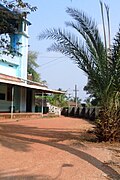 Pullippadam Mosque
 -
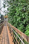 Hanging Bridge to Pullippadam
 -
 River Chaliyar at Mampad
.jpg)

.jpg)
File:MAMPAD panjayath