

>Prajjwal3959 →Gallery: image added #WPWP |
imported>Tizen03 To avoid confusion between Bodo-Kachari and Boro people |
||
| Line 45: | Line 45: | ||
|designation1_free2value = | |designation1_free2value = | ||
}} | }} | ||
{{Assam History}} | |||
'''Bhismaknagar''' is an archeological site in Indian state of [[Arunachal Pradesh]]. It is located near [[Roing]] in [[Lower Dibang Valley district|Lower Dibang Valley]] district.<ref name="apgov">{{cite news| title=Bhismaknagar | url=http://arunachalpradesh.gov.in/bnagar.htm|publisher= Government of Arunachal Pradesh | archive-url=https://web.archive.org/web/20170611120146/http://arunachalpradesh.gov.in/bnagar.htm |archive-date = 11 June 2017}}</ref>The remains are generally ascribe to the rule of the [[Chutia people|Chutias]], a Kachari ethnic group<ref>{{harvcol|Shin|2020|p=51}} The Chutias belong to the Bodos, a linguistic group of the Brahmaputra valley, speaking a Tibeto-Burman language and having different cognate groups within them.</ref> who ruled over the region of Sadiya from 11th to 16th Century CE. <ref>http://asiguwahaticircle.gov.in/bhismaknagar.html Remains at Bhismaknagar (ASI official website), "The remains are generally ascribe to he rule of the 'Chutias', a Tibeto-Burmese tribe who ruled over the region of Sadiya from 11th to 16th Century CE."</ref> | |||
==Etymology== | |||
The name ''Bhismaknagar'' was first observed in the Assam District Gazetteer of the year 1928<ref>"Assam District Gazetteers: 1928(Volume XI), p. 19,"Again at Bishemnagar or Bishmuknagar, situated near Chipulin village up the Balijan(Sunpura) river and accessible from mile 27 on the Lohit valley road, is the remains of a large fort and settlement. It is supposed to have been built by Raja Bishmook or Bhikrum, Raja of Kundilpur, father of Rukmini."</ref>—reference to a work by the 16th-century seer [[Sankardev]] that was popular in the [[Sadiya]] region (which eventually found its way into the later Chutia chronicles).<ref>"Among many works of Śankaradeva, the Rukmiṇiharaṇa, the poem of Rukmimi and Krishna, gained considerable popularity in the Sadiya area and influenced its regional identity construction. Rukmiṇī, in this poem, was a daughter of king Bhīṣmaka" {{harvcol|Shin|2020|p=55}} "The Bhīṣmaka lineage became a part of the new literary tradition of the region and eventually found its way into the later Chutiya chronicles."{{harvcol|Shin|2020|p=57}}</ref> | |||
Historically, the region was known as ''Sadhayapura'' (the rulers being Sadhayapur-ishwar) as per copper inscriptions<ref>"Furthermore, it is fairly certain from the dates available in the inscriptions that Nandin and Satyanārāyaṇa ruled Sadhayāpurī in the latter half of the fourteenth century, while Lakṣmīnārāyaṇa belonged to the beginning, and Dharmanārāyaṇa to the middle of the fifteenth century. It is also nearly clear that Sadhayāpurī (or Svadhayāpurī) mentioned in the inscriptions is the same as Sadhiyā or Sadiya of later times." {{harvcol|Shin|2020|p=52}}</ref> and the fort formed part of the capital region of the Chutia king ''Laksminarayana'',<ref>"The ruins of two forts in Lohit district of Arunachal Pradesh are said to be the remains of Bhīṣmaka’s city, viz. Bhismaknagar (sk. Bhīṣmakanagara): one ruin about 16 miles northwest of Sadiya at the foot of the hills between the rivers Dikrang and Dibang is known as the fort of Bhīṣmaka, and the other about 24 miles north of Sadiya between the gorges of those two rivers is believed to be the fort of Śiśupāla. Based on an inscribed brick with the name of Śrī-śrī-Lakṣmīnārāyaṇa, discovered from the ruins of the forts in Bhismaknagar, it is assumed that Chutiya king Lakṣmīnārāyaṇa of the early fifteenth century had his capital in the area. The paleographical analysis of the inscription supports this dating." {{harvcol|Shin|2020|p=56}}</ref> also known as ''Che-lung'' in Tai Buranjis (meaning "Great City" in English). | |||
==Location== | ==Location== | ||
| Line 57: | Line 58: | ||
==History== | ==History== | ||
Bhismaknagar is an important ancient archeological site. The site must have been a stronghold of the [[Chutia Kingdom|Chutias]]. The ruins have been dated between the 11th-15th centuries.<ref>{{cite book|url=https://books.google.co.in/books?redir_esc=y&id=194smwEACAAJ&focus=searchwithinvolume&q=bhismaknagar |author1=Tage Tada |author2=J. C. Dutta |author3=Nabajit Deori |year=2012 |publisher=Government of Arunachal Pradesh, Department of Cultural Affairs, Directorate of Research |title=Archaeological Heritage of Arunachal Pradesh |page=8}}</ref> Bhismaknagar has been identified with Sadhayapuri (or Svadhayapuri), the political centre of the [[Chutia Kingdom]].<ref>{{cite book|last1=Momin|first1=Mignonette|last2=Mawlong|first2=Cecile A.|last3=Qādrī|first3=Fuz̤ail Aḥmad|title=Society and Economy in North-East India|date=2004|publisher=Regency Publications|isbn=9788189233402|page=47|url=https://books.google.com/books?id=Djx131iEeYkC|language=en}}</ref> Based on insription of bricks, it is assumed to be the capital of Chutia king Lakṣmīnārāyaṇa of the early fifteenth century. The paleographical analysis of the inscription supports this dating.<ref name="shin20_56">Based on an inscribed brick with the name of Śrīśrī-Lakṣmīnārāyaṇa, discovered from the ruins of the forts in Bhismaknagar, it is assumed that Chutiya king Lakṣmīnārāyaṇa of the early fifteenth century had his capital in the area. The paleographical analysis of the inscription supports this dating {{harvcol|Shin|2020|p=56}}</ref> | |||
Bhismaknagar is an important ancient archeological site. | |||
==Architecture== | ==Architecture== | ||
The fort, with its fortifications and buildings, is built of fired bricks. The fortified city is spread over an area of 10 square km. The wall is 4.5 meters high and 6 meters wide, made using granite stone (6-9 courses)<ref>Gait, Edward. ''A history of Assam(2nd Edition)''. 1962, p. 16.</ref><ref>Tada, Tage, "Archaeological remains of Arunachal Pradesh up to 16th century", p. 114</ref> <ref>Chattopadhyay, Subid, "History and archaeology of Arunachal Pradesh"</ref> and bricks on the east, west and south directions. In the north, the Mishmi hills provided a natural barrier. Although very less excavation has been carried out by the Arunachal government, preliminary excavations have revealed three tanks and two gates in the eastern and western directions.<ref>Raikar, Yashawant. ''Archeology in Arunachal Pradesh''. 1980, p. 19.</ref> | |||
The Bhismaknagar central complex extended over an area of 1860 square meters and displays three halls, six ingresses and two extension rooms. There is also a 2 meters high stone wall inside the complex. The architecture of the fort displays the medieval culture. While quarrying the fort the enormous pieces of work of art like potteries, terracotta figurines, terracotta plaques and decorative tiles were preserved. | The Bhismaknagar central complex extended over an area of 1860 square meters and displays three halls, six ingresses and two extension rooms. There is also a 2 meters high stone wall inside the complex. The architecture of the fort displays the medieval culture. While quarrying the fort the enormous pieces of work of art like potteries, terracotta figurines, terracotta plaques and decorative tiles were preserved.<ref>Tada, Tage, "Archaeological remains of Arunachal Pradesh up to 16th century", p. 114</ref> | ||
==Gallery== | ==Gallery== | ||
<gallery mode="packed"> | <gallery mode="packed"> | ||
File:Bhismaknagar fort ruins.jpg| | File:Bhismaknagar fort ruins.jpg|A section of the brick platform of Bhismaknagar. | ||
File:Another section of the palace.jpg| | File:Another section of the palace.jpg|Section of the fortified brick wall leading to the western gateway. | ||
File:Bhismakanagar Wall.jpg|A section of the | File:Bhismakanagar Wall.jpg|A section of the eastern brick gateway of the city. | ||
File:A section of a wall in Bhismaknagar.jpg|A section of wall | File:A section of a wall in Bhismaknagar.jpg|A section of the western gateway with the upper damaged portion of the wall removed. | ||
File:Bhismaknagar Brick Wall.jpg|A section of the wall | File:Bhismaknagar Brick Wall.jpg|A section of the brick wall leading to the eastern gateway. | ||
File:Bhismaknagar wall section.jpg| | File:Bhismaknagar wall section.jpg| Another section of the Western wall. | ||
File:Bhismanagar fort ruins.jpg| | File:Bhismanagar fort ruins.jpg|The three compartments of the central building. | ||
File:A separate structure inside the fortified walls.jpg|A separate structure inside the fortified walls. | File:A separate structure inside the fortified walls.jpg|A separate structure inside the fortified walls. | ||
File:Central structure of Bhismaknagar.jpg|Central | File:Central structure of Bhismaknagar.jpg|Central platform of Bhismaknagar. | ||
File:Lakshminarayan brick.jpg|A brick found in Bhismaknagar Fort with the Chutia king Lakshminarayan's name inscribed in it. | File:Lakshminarayan brick.jpg|A brick found in Bhismaknagar Fort with the Chutia king Lakshminarayan's name inscribed in it. | ||
File:Bhismaknagar building.jpg| | File:Bhismaknagar building.jpg|Western gateway with the upper damaged portions removed. | ||
File:Potsherds found in Bhisnaknagar.jpg|Potsherds found in Bhismaknagar. | File:Potsherds found in Bhisnaknagar.jpg|Potsherds found in Bhismaknagar. | ||
File:A section of the central building of Bhismaknagar.jpg|A section of the central building of Bhismaknagar. | File:A section of the central building of Bhismaknagar.jpg|A section of the central building of Bhismaknagar. | ||
File:Mud pot with holes.jpg|Mud pot with holes. | File:Mud pot with holes.jpg|Mud pot with holes. | ||
File:Brick of Bhismaknagar.jpg|Brick of Bhismaknagar. | File:Brick of Bhismaknagar.jpg|Brick of Bhismaknagar. | ||
File:Bhismaknagar Ruins.jpg| | File:Bhismaknagar Ruins.jpg|Section of the western brick wall. | ||
File:A section of wall in Bhismaknagar.jpg|A section of wall in Bhismaknagar | File:A section of wall in Bhismaknagar.jpg|A section of western wall in Bhismaknagar | ||
File:Various artifacts found in Bhismaknagar.jpg|Various artifacts found in Bhismaknagar. | File:Various artifacts found in Bhismaknagar.jpg|Various artifacts found in Bhismaknagar. | ||
File:Bhismaknagar complex.jpg|Bhismaknagar complex | File:Bhismaknagar complex.jpg|Bhismaknagar complex | ||
A brick platform of Bishmak Nagar temple in Arunachal Pradesh.jpg|A brick platform of Bishmak Nagar temple in Arunachal Pradesh | A brick platform of Bishmak Nagar temple in Arunachal Pradesh.jpg|A brick platform of Bishmak Nagar temple in Arunachal Pradesh | ||
File:A stack of bricks of Bishmak Nagar Ruins.jpg|A stack of bricks of Bishmak Nagar Ruins | File:A stack of bricks of Bishmak Nagar Ruins.jpg|A stack of bricks of Bishmak Nagar ruins. | ||
File:Ruins of Bishmak Nagar in Arunachal Pradesh.jpg|Another view of the platform of the central building. | |||
</gallery> | </gallery> | ||
Latest revision as of 01:00, 4 September 2021
 Museum history sign | |
  Location of Bhismaknagar in India  Location of Bhismaknagar in Arunachal Pradesh, India | |
| Alternative name | Sadhayapur |
|---|---|
| Location | Lohit district, Arunachal Pradesh, India |
| Coordinates | 28°02′48.2″N 96°0′20.7″E / 28.046722°N 96.005750°E |
| Type | Settlement |
| Length | 4.5 km |
| Width | 2.5 km |
| History | |
| Material | Bricks, Stone, Soil |
| Founded | 8th century |
| Abandoned | 16th century |
| Part of a series on the |
| History of Assam |
|---|
 |
| Categories |
Bhismaknagar is an archeological site in Indian state of Arunachal Pradesh. It is located near Roing in Lower Dibang Valley district.[1]The remains are generally ascribe to the rule of the Chutias, a Kachari ethnic group[2] who ruled over the region of Sadiya from 11th to 16th Century CE. [3]
Etymology[edit | edit source]
The name Bhismaknagar was first observed in the Assam District Gazetteer of the year 1928[4]—reference to a work by the 16th-century seer Sankardev that was popular in the Sadiya region (which eventually found its way into the later Chutia chronicles).[5]
Historically, the region was known as Sadhayapura (the rulers being Sadhayapur-ishwar) as per copper inscriptions[6] and the fort formed part of the capital region of the Chutia king Laksminarayana,[7] also known as Che-lung in Tai Buranjis (meaning "Great City" in English).
Location[edit | edit source]
It is located in Lower Dibang Valley district. The campus of the old city is spread over an area of 2500 acres.
History[edit | edit source]
Bhismaknagar is an important ancient archeological site. The site must have been a stronghold of the Chutias. The ruins have been dated between the 11th-15th centuries.[8] Bhismaknagar has been identified with Sadhayapuri (or Svadhayapuri), the political centre of the Chutia Kingdom.[9] Based on insription of bricks, it is assumed to be the capital of Chutia king Lakṣmīnārāyaṇa of the early fifteenth century. The paleographical analysis of the inscription supports this dating.[10]
Architecture[edit | edit source]
The fort, with its fortifications and buildings, is built of fired bricks. The fortified city is spread over an area of 10 square km. The wall is 4.5 meters high and 6 meters wide, made using granite stone (6-9 courses)[11][12] [13] and bricks on the east, west and south directions. In the north, the Mishmi hills provided a natural barrier. Although very less excavation has been carried out by the Arunachal government, preliminary excavations have revealed three tanks and two gates in the eastern and western directions.[14]
The Bhismaknagar central complex extended over an area of 1860 square meters and displays three halls, six ingresses and two extension rooms. There is also a 2 meters high stone wall inside the complex. The architecture of the fort displays the medieval culture. While quarrying the fort the enormous pieces of work of art like potteries, terracotta figurines, terracotta plaques and decorative tiles were preserved.[15]
Gallery[edit | edit source]
-
 A section of the brick platform of Bhismaknagar.
 -
 Section of the fortified brick wall leading to the western gateway.
 -
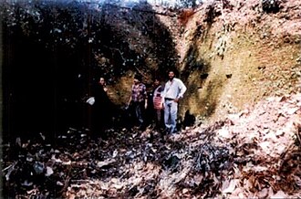 A section of the eastern brick gateway of the city.
 -
 A section of the western gateway with the upper damaged portion of the wall removed.
 -
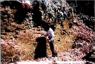 A section of the brick wall leading to the eastern gateway.
 -
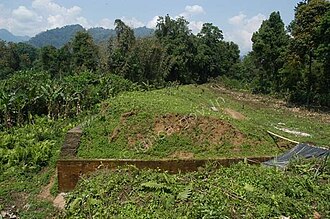 Another section of the Western wall.
 -
 The three compartments of the central building.
 -
 A separate structure inside the fortified walls.
 -
 Central platform of Bhismaknagar.
 -
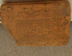 A brick found in Bhismaknagar Fort with the Chutia king Lakshminarayan's name inscribed in it.
 -
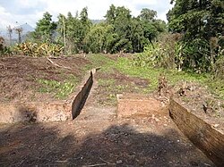 Western gateway with the upper damaged portions removed.
 -
 Potsherds found in Bhismaknagar.
 -
 A section of the central building of Bhismaknagar.
 -
 Mud pot with holes.
 -
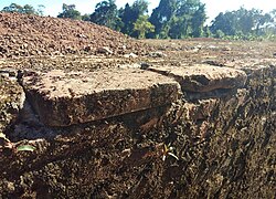 Brick of Bhismaknagar.
 -
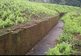 Section of the western brick wall.
 -
 A section of western wall in Bhismaknagar
 -
 Various artifacts found in Bhismaknagar.
 -
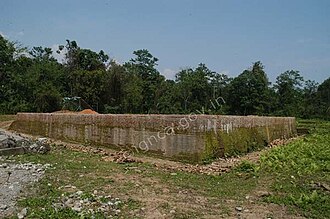 Bhismaknagar complex
 -
 A brick platform of Bishmak Nagar temple in Arunachal Pradesh
 -
 A stack of bricks of Bishmak Nagar ruins.
 -
 Another view of the platform of the central building.


Notes[edit | edit source]
- ↑ "Bhismaknagar". Government of Arunachal Pradesh. Archived from the original on 11 June 2017.
- ↑ (Shin 2020:51) The Chutias belong to the Bodos, a linguistic group of the Brahmaputra valley, speaking a Tibeto-Burman language and having different cognate groups within them.
- ↑ http://asiguwahaticircle.gov.in/bhismaknagar.html Remains at Bhismaknagar (ASI official website), "The remains are generally ascribe to he rule of the 'Chutias', a Tibeto-Burmese tribe who ruled over the region of Sadiya from 11th to 16th Century CE."
- ↑ "Assam District Gazetteers: 1928(Volume XI), p. 19,"Again at Bishemnagar or Bishmuknagar, situated near Chipulin village up the Balijan(Sunpura) river and accessible from mile 27 on the Lohit valley road, is the remains of a large fort and settlement. It is supposed to have been built by Raja Bishmook or Bhikrum, Raja of Kundilpur, father of Rukmini."
- ↑ "Among many works of Śankaradeva, the Rukmiṇiharaṇa, the poem of Rukmimi and Krishna, gained considerable popularity in the Sadiya area and influenced its regional identity construction. Rukmiṇī, in this poem, was a daughter of king Bhīṣmaka" (Shin 2020:55) "The Bhīṣmaka lineage became a part of the new literary tradition of the region and eventually found its way into the later Chutiya chronicles."(Shin 2020:57)
- ↑ "Furthermore, it is fairly certain from the dates available in the inscriptions that Nandin and Satyanārāyaṇa ruled Sadhayāpurī in the latter half of the fourteenth century, while Lakṣmīnārāyaṇa belonged to the beginning, and Dharmanārāyaṇa to the middle of the fifteenth century. It is also nearly clear that Sadhayāpurī (or Svadhayāpurī) mentioned in the inscriptions is the same as Sadhiyā or Sadiya of later times." (Shin 2020:52)
- ↑ "The ruins of two forts in Lohit district of Arunachal Pradesh are said to be the remains of Bhīṣmaka’s city, viz. Bhismaknagar (sk. Bhīṣmakanagara): one ruin about 16 miles northwest of Sadiya at the foot of the hills between the rivers Dikrang and Dibang is known as the fort of Bhīṣmaka, and the other about 24 miles north of Sadiya between the gorges of those two rivers is believed to be the fort of Śiśupāla. Based on an inscribed brick with the name of Śrī-śrī-Lakṣmīnārāyaṇa, discovered from the ruins of the forts in Bhismaknagar, it is assumed that Chutiya king Lakṣmīnārāyaṇa of the early fifteenth century had his capital in the area. The paleographical analysis of the inscription supports this dating." (Shin 2020:56)
- ↑ Tage Tada; J. C. Dutta; Nabajit Deori (2012). Archaeological Heritage of Arunachal Pradesh. Government of Arunachal Pradesh, Department of Cultural Affairs, Directorate of Research. p. 8.
- ↑ Momin, Mignonette; Mawlong, Cecile A.; Qādrī, Fuz̤ail Aḥmad (2004). Society and Economy in North-East India. Regency Publications. p. 47. ISBN 9788189233402.
- ↑ Based on an inscribed brick with the name of Śrīśrī-Lakṣmīnārāyaṇa, discovered from the ruins of the forts in Bhismaknagar, it is assumed that Chutiya king Lakṣmīnārāyaṇa of the early fifteenth century had his capital in the area. The paleographical analysis of the inscription supports this dating (Shin 2020:56)
- ↑ Gait, Edward. A history of Assam(2nd Edition). 1962, p. 16.
- ↑ Tada, Tage, "Archaeological remains of Arunachal Pradesh up to 16th century", p. 114
- ↑ Chattopadhyay, Subid, "History and archaeology of Arunachal Pradesh"
- ↑ Raikar, Yashawant. Archeology in Arunachal Pradesh. 1980, p. 19.
- ↑ Tada, Tage, "Archaeological remains of Arunachal Pradesh up to 16th century", p. 114
References[edit | edit source]
- Shin, Jae-Eun (2020). "Descending from demons, ascending to kshatriyas: Genealogical claims and political process in pre-modern Northeast India, The Chutiyas and the Dimasas". The Indian Economic and Social History Review. 57 (1): 49–75. doi:10.1177/0019464619894134. S2CID 213213265.