

Kamal Guha (talk | contribs) Template order changed |
Kamal Guha (talk | contribs) Corrections |
||
| Line 5: | Line 5: | ||
| other_name = | | other_name = | ||
| nickname = | | nickname = | ||
| settlement_type = | | settlement_type = Town | ||
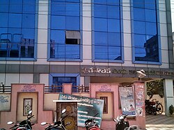
| image_skyline = File:Repalle railway station sign board.jpg | | image_skyline = File:Repalle railway station sign board.jpg | ||
| image_alt = | | image_alt = | ||
| Line 20: | Line 20: | ||
| subdivision_type2 = [[List of districts of India|District]] | | subdivision_type2 = [[List of districts of India|District]] | ||
| subdivision_name2 = [[Bapatla district|Bapatla]] | | subdivision_name2 = [[Bapatla district|Bapatla]] | ||
| subdivision_type3 = [[ | | subdivision_type3 = [[Mandal]] | ||
| subdivision_name3 = [[Repalle mandal|Repalle]] | | subdivision_name3 = [[Repalle mandal|Repalle]] | ||
| established_title = <!-- Established --> | | established_title = <!-- Established --> | ||
| Line 29: | Line 29: | ||
| government_footnotes = | | government_footnotes = | ||
| government_type = | | government_type = | ||
| governing_body = [[Repalle Municipality]]<br /> | | governing_body = [[Repalle Municipality]]<br />Andhra Pradesh Capital Region Development Authority | ||
| leader_party = [[Telugu Desam Party]] | | leader_party = [[Telugu Desam Party]] | ||
| leader_title = [[Member of Legislative Assembly (India)|MLA]] | | leader_title = [[Member of Legislative Assembly (India)|MLA]] | ||
| leader_name = Anagani Satya Prasad | | leader_name = Anagani Satya Prasad | ||
| leader_title1 = | | leader_title1 = Municipal commissioner | ||
| leader_name1 = Vijay saradhi | | leader_name1 = Vijay saradhi | ||
| area_footnotes = <ref name="municipal_info">{{Cite web |title=Brief about Municipality |url=http://cdma.ap.gov.in/REPALLE/Basic_information_Municipality.html |access-date=17 November 2014 |publisher=Commissioner & Director of Municipal Administration}}</ref> | | area_footnotes = <ref name="municipal_info">{{Cite web |title=Brief about Municipality |url=http://cdma.ap.gov.in/REPALLE/Basic_information_Municipality.html |access-date=17 November 2014 |publisher=Commissioner & Director of Municipal Administration}}</ref> | ||
| area_rank = | | area_rank = 23rd | ||
| area_total_km2 = 10.97 | | area_total_km2 = 10.97 | ||
| unit_pref = Metric | | unit_pref = Metric | ||
| Line 47: | Line 47: | ||
| population_demonym = | | population_demonym = | ||
| population_footnotes = <ref name="population">{{Cite web |title=Census 2011 |url=http://www.censusindia.gov.in/pca/SearchDetails.aspx?Id=631659 |access-date=16 November 2014 |publisher=The Registrar General & Census Commissioner, India}}</ref><ref>{{Cite web |title=Statistical Abstract of Andhra Pradesh, 2015 |url=https://desap.cgg.gov.in/jsp/website/gallery/Statistical%20Abstract%202015.pdf |access-date=26 April 2019 |website=Directorate of Economics & Statistics |publisher=Government of Andhra Pradesh |pages=43 |format=PDF}}</ref> | | population_footnotes = <ref name="population">{{Cite web |title=Census 2011 |url=http://www.censusindia.gov.in/pca/SearchDetails.aspx?Id=631659 |access-date=16 November 2014 |publisher=The Registrar General & Census Commissioner, India}}</ref><ref>{{Cite web |title=Statistical Abstract of Andhra Pradesh, 2015 |url=https://desap.cgg.gov.in/jsp/website/gallery/Statistical%20Abstract%202015.pdf |access-date=26 April 2019 |website=Directorate of Economics & Statistics |publisher=Government of Andhra Pradesh |pages=43 |format=PDF}}</ref> | ||
| demographics_type1 = | | demographics_type1 = [[Language]] | ||
| demographics1_title1 = Official | | demographics1_title1 = Official | ||
| demographics1_info1 = [[Telugu language|Telugu]] | | demographics1_info1 = [[Telugu language|Telugu]] | ||
| Line 58: | Line 58: | ||
| registration_plate = AP–39 | | registration_plate = AP–39 | ||
| blank_name_sec1 = [[List of constituencies of the Lok Sabha#Andhra Pradesh (25)|Lok Sabha constituency]] | | blank_name_sec1 = [[List of constituencies of the Lok Sabha#Andhra Pradesh (25)|Lok Sabha constituency]] | ||
| blank_info_sec1 = [[Bapatla | | blank_info_sec1 = [[Bapatla (Lok Sabha constituency)|Bapatla (SC)]] | ||
| blank1_name_sec2 = | | blank1_name_sec2 = Assembly constituency | ||
| blank1_info_sec2 = [[Repalle (Assembly constituency)|Repalle]] | | blank1_info_sec2 = [[Repalle (Assembly constituency)|Repalle]] | ||
| website = {{URL|http://repalle.cdma.ap.gov.in/en}} | | website = {{URL|http://repalle.cdma.ap.gov.in/en}} | ||
| Line 74: | Line 74: | ||
== Geography == | == Geography == | ||
Repalle is located at {{Coord|16.01|N|80.51|E|}}.<ref>{{Cite web |title=Repalle, India Page |url=http://www.fallingrain.com/world/IN/02/Repalle.html |access-date=2006-08-16}}</ref> It has an average elevation of {{Convert|7|m|ft|abbr=on}} and situated {{Convert|10.62|km|mi|abbr=on}}.<ref name="basic">{{Cite web |title=Public services/amenities |url=http://cdma.ap.gov.in/REPALLE/index.html |access-date=17 November 2014 |publisher=Commissioner & Director of Municipal Administration}}</ref> The nearest towns are [[Tenali]], [[Bapatla]] in the [[ | Repalle is located at {{Coord|16.01|N|80.51|E|}}.<ref>{{Cite web |title=Repalle, India Page |url=http://www.fallingrain.com/world/IN/02/Repalle.html |access-date=2006-08-16}}</ref> It has an average elevation of {{Convert|7|m|ft|abbr=on}} and situated {{Convert|10.62|km|mi|abbr=on}}.<ref name="basic">{{Cite web |title=Public services/amenities |url=http://cdma.ap.gov.in/REPALLE/index.html |access-date=17 November 2014 |publisher=Commissioner & Director of Municipal Administration}}</ref> The nearest towns are [[Tenali]], [[Bapatla]] in the [[Bapatla district]], and [[Machilipatnam]] in the [[Krishna district]]. | ||
== Climate == | == Climate == | ||
| Line 88: | Line 88: | ||
=== Civic Administration === | === Civic Administration === | ||
[[Repalle Municipality]] is a second grade | [[Repalle Municipality]] is a second grade municipality, which was established in the year 1965. It is spread over an area of {{Convert|10.97|km2|abbr=on}}.<ref>{{Cite web |title=Basic Information of Municipality |url=http://cdma.ap.gov.in/REPALLE/Basic_information_Municipality.html |archive-url=https://web.archive.org/web/20141129092932/http://cdma.ap.gov.in/REPALLE/Basic_information_Municipality.html |archive-date=29 November 2014 |access-date=24 December 2015 |website=Municipal Administration & Urban Development Department |publisher=Government of Telangana}}</ref> It has 28 wards with an extent of {{convert|10.97|km2|mi2|abbr=on}}. The present Municipal Commissioner of the town is Vijaya Saradhi.<ref>{{Cite web |title=Municipality commissioner |url=http://cdma.ap.gov.in/Municipality_Contacts.html |url-status=dead |archive-url=https://web.archive.org/web/20150515172537/http://cdma.ap.gov.in/Municipality_Contacts.html |archive-date=15 May 2015 |access-date=8 May 2015 |website=Commissioner & Director of Municipal Administration |publisher=Government of Andhra Pradesh}}</ref> The present Municipal Chairperson of the town is smt.Katta Mangi of [[Telugu Desam Party|Yscrp]]. The municipal department maintains amenities such as public taps, public bore-wells, drains, roads, street lights, public parks etc. Others include dispensaries, elementary and secondary schools etc.<ref>{{Cite web |title=Public services/amenities |url=http://cdma.ap.gov.in/REPALLE/Public%20services_amenities.html |access-date=31 March 2016 |publisher=Commissioner & Director of Municipal Administration}}</ref> | ||
=== Politics === | === Politics === | ||
Repalle is a part of [[Repalle (Assembly constituency)|Repalle Assembly constituency]] for [[Andhra Pradesh Legislative Assembly]]. [[Anagani Satya Prasad]] is the present [[Member of the Legislative Assembly (India)|MLA]] of the constituency from [[Telugu Desam Party]].<ref>{{Cite web |title=MLA |url=http://www.ap.gov.in/government/mla/ |access-date=13 October 2014 |publisher=AP State Portal}}</ref> The assembly segment in turn is a part of [[Bapatla | Repalle is a part of [[Repalle (Assembly constituency)|Repalle Assembly constituency]] for [[Andhra Pradesh Legislative Assembly]]. [[Anagani Satya Prasad]] is the present [[Member of the Legislative Assembly (India)|MLA]] of the constituency from [[Telugu Desam Party]].<ref>{{Cite web |title=MLA |url=http://www.ap.gov.in/government/mla/ |access-date=13 October 2014 |publisher=AP State Portal}}</ref> The assembly segment in turn is a part of [[Bapatla (Lok Sabha constituency)|Bapatla (SC) Lok Sabha constituency]], which was won by Nandigam Suresh of [[Telugu Desam Party|YuvajanaSramikaRaithuCongress Party(ysrcp)]].<ref>{{Cite web |title=Delimitation of Parliamentary and Assembly Constituencies Order, 2008 |url=http://eci.nic.in/eci_main/CurrentElections/CONSOLIDATED_ORDER%20_ECI%20.pdf |access-date=11 October 2014 |publisher=Election Commission of India |page=22,31 |format=PDF}}</ref><ref>{{Cite web |title=MP (Lok Sabha) |url=http://www.ap.gov.in/government/mp-lok-sabha/ |access-date=4 May 2015 |publisher=Government of AP}}</ref> | ||
== Notable people == | == Notable people == | ||
| Line 97: | Line 97: | ||
*[[S. Janaki]], [[playback singer]] | *[[S. Janaki]], [[playback singer]] | ||
*[[Samudrala Sr.]], screenwriter | *[[Samudrala Sr.]], screenwriter | ||
*[[C. V. S. K. Sarma]], | *[[C. V. S. K. Sarma]], economist and a retired [[Indian Administrative Service|IAS]] officer | ||
* | *Chittoor V. Nagaiah | ||
== Transport == | == Transport == | ||
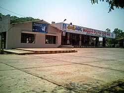
[[File:Repalle bus station.jpg|thumb|Repalle bus station|left]] | [[File:Repalle bus station.jpg|thumb|Repalle bus station|left]] | ||
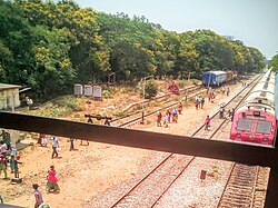
[[File:Repalle railway station.jpg|thumb|Repalle railway station overview]] | [[File:Repalle railway station.jpg|thumb|Repalle railway station overview]] | ||
The town has a total road length of {{Convert|115.10|km|mi|abbr=on}}.<ref>{{Cite web |title=Details of Roads in Each ULB of Andhra Pradesh |url=http://centralapp.cdma.ap.gov.in:8080/CDMAAPTaxesInfo/RoadDetails.jsp |url-status=dead |archive-url=https://web.archive.org/web/20160801101300/http://centralapp.cdma.ap.gov.in:8080/CDMAAPTaxesInfo/RoadDetails.jsp |archive-date=1 August 2016 |access-date=28 March 2017 |website=Commissioner and Directorate of Municipal Administration |publisher=Municipal Administration and Urban Development Department – Government of Andhra Pradesh}}</ref> The | The town has a total road length of {{Convert|115.10|km|mi|abbr=on}}.<ref>{{Cite web |title=Details of Roads in Each ULB of Andhra Pradesh |url=http://centralapp.cdma.ap.gov.in:8080/CDMAAPTaxesInfo/RoadDetails.jsp |url-status=dead |archive-url=https://web.archive.org/web/20160801101300/http://centralapp.cdma.ap.gov.in:8080/CDMAAPTaxesInfo/RoadDetails.jsp |archive-date=1 August 2016 |access-date=28 March 2017 |website=Commissioner and Directorate of Municipal Administration |publisher=Municipal Administration and Urban Development Department – Government of Andhra Pradesh}}</ref> The Repalle bus station is owned and operated by [[Andhra Pradesh State Road Transport Corporation|APSRTC]].<ref>{{Cite web |title=Bus Stations in Districts |url=http://www.apsrtc.gov.in/Bus%20Stations.aspx |access-date=15 March 2016 |website=Andhra Pradesh State Road Transport Corporation}}</ref><ref>{{Cite news |date=25 May 2012 |title=Violent protests over Mopidevi’s arrest in Repalle, Nizampatnam and Nagaram mandals |work=The Times of India |location=Repalle |url=https://timesofindia.indiatimes.com/city/hyderabad/Violent-protests-over-Mopidevis-arrest-in-Repalle-Nizampatnam-and-Nagaram-mandals/articleshow/13459905.cms |url-status=live |access-date=15 March 2016 |archive-url=https://web.archive.org/web/20190220134906/https://timesofindia.indiatimes.com/city/hyderabad/Violent-protests-over-Mopidevis-arrest-in-Repalle-Nizampatnam-and-Nagaram-mandals/articleshow/13459905.cms |archive-date=20 February 2019}}</ref> The bus station is also equipped with a [[Bus garage|bus depot]] for storage and maintenance of buses.<ref>{{Cite web |title=Depot Name |url=http://www.apsrtc.gov.in/Depots.aspx |access-date=15 March 2016 |website=[[APSRTC]]}}</ref><ref>{{Cite news |date=28 September 2006 |title=Reprieve for Ponnur depot |work=The Hans India |location=Guntur |url=https://www.thehindu.com/todays-paper/tp-national/tp-andhrapradesh/reprieve-for-ponnur-depot/article3082376.ece |url-status=live |access-date=15 March 2016 |archive-url=https://web.archive.org/web/20180630011207/https://www.thehindu.com/todays-paper/tp-national/tp-andhrapradesh/reprieve-for-ponnur-depot/article3082376.ece |archive-date=30 June 2018}}</ref> The [[National Highway 216 (India)|National Highway 216]] passes by the village [[Penumudi]] near to {{rws|Repalle}}, which connects [[Digamarru]] and [[Ongole]].<ref>{{Cite web |title=National Highways in A.P |url=http://www.aponline.gov.in/Quick%20Links/Departments/Transport,%20Roads%20and%20Buildings/CE%20(R&B),%20National%20Highways/About/index.html |url-status=dead |archive-url=https://web.archive.org/web/20131010072137/http://www.aponline.gov.in/Quick%20Links/Departments/Transport%2C%20Roads%20and%20Buildings/CE%20%28R%26B%29%2C%20National%20Highways/About/index.html |archive-date=10 October 2013 |access-date=4 August 2014 |publisher=AP Online Portal}}</ref> {{rws|Repalle}} is a ''B–category'' terminus station on the [[Tenali–Repalle branch line]] of Guntur railway division.<ref>{{Cite web |title=Vijayawada division – A Profile |url=http://www.scr.indianrailways.gov.in/cris/uploads/files/1448370249434-Division%20Profile.pdf |archive-url=https://web.archive.org/web/20160128163230/http://www.scr.indianrailways.gov.in/cris/uploads/files/1448370249434-Division%20Profile.pdf |archive-date=28 January 2016 |access-date=29 February 2016 |website=South Central Railway |format=PDF}}</ref> | ||
== Education == | == Education == | ||
| Line 118: | Line 118: | ||
{{Municipalities of Andhra Pradesh}} | {{Municipalities of Andhra Pradesh}} | ||
{{ | {{Bapatla district}} | ||
[[Category:Cities and towns in | [[Category:Cities and towns in Bapatla district]] | ||
[[Category:Mandal headquarters in | [[Category:Mandal headquarters in Bapatla district]] | ||
Revision as of 08:05, 23 August 2023
Repalle | |
|---|---|
Town | |
 Repalle railway station sign board | |
  Repalle Location in Andhra Pradesh, India | |
| Coordinates: 16°01′02″N 80°49′46″E / 16.01722°N 80.82944°E | |
| Country | India |
| State | Andhra Pradesh |
| District | Bapatla |
| Mandal | Repalle |
| Government | |
| • Body | Repalle Municipality Andhra Pradesh Capital Region Development Authority |
| • MLA | Anagani Satya Prasad (Telugu Desam Party) |
| • Municipal commissioner | Vijay saradhi |
| Area | |
| • Total | 10.97 km2 (4.24 sq mi) |
| • Rank | 23rd |
| Elevation | 10 m (30 ft) |
| Population | |
| • Total | 50,866 |
| • Density | 4,600/km2 (12,000/sq mi) |
| Language | |
| • Official | Telugu |
| Time zone | UTC+5:30 (IST) |
| PIN | 522265 |
| Telephone code | +91–8648 |
| Vehicle registration | AP–39 |
| Lok Sabha constituency | Bapatla (SC) |
| Assembly constituency | Repalle |
| Website | repalle |
Repalle is a town in Bapatla district of the Indian state of Andhra Pradesh. The town is one of the 12 municipalities in Bapatla district and the headquarters of Repalle mandal under the administration of Bapatla revenue division.[5][6] It is situated near Krishna River in the Coastal Andhra region of the state.[7]
History
The name Repalle is actually formed from two words: Revu (river or bank of the river) and Palle (village). Originally known as Revupalle, the name has evolved to Repalle over time.[citation needed]
Geography
Repalle is located at 16°01′N 80°31′E / 16.01°N 80.51°E.[8] It has an average elevation of 7 m (23 ft) and situated 10.62 km (6.60 mi).[9] The nearest towns are Tenali, Bapatla in the Bapatla district, and Machilipatnam in the Krishna district.
Climate
 | This section needs more citations. (January 2021) |
Repalle is located 25 km from the sea coast. It is generally hot and humid during summer with temperatures ranging between 28 and 42 C on average. Winters are milder with temperatures between 15 and 30 C on average. Heavy rains are experienced between July and November during monsoon time.
Demographics
As of 2011[update] census, the town had a population of 50,866. The total population constitute, 24,385 males and 26,481 females —a sex ratio of 1086 females per 1000 males. 4,308 children are in the age group of 0–6 years, of which 2,184 are boys and 2,124 are girls. The average literacy rate stands at 81.32% with 37,862 literates, significantly higher than the state average of 67.41%.[3][10]
Government and politics

Civic Administration
Repalle Municipality is a second grade municipality, which was established in the year 1965. It is spread over an area of 10.97 km2 (4.24 sq mi).[11] It has 28 wards with an extent of 10.97 km2 (4.24 sq mi). The present Municipal Commissioner of the town is Vijaya Saradhi.[12] The present Municipal Chairperson of the town is smt.Katta Mangi of Yscrp. The municipal department maintains amenities such as public taps, public bore-wells, drains, roads, street lights, public parks etc. Others include dispensaries, elementary and secondary schools etc.[13]
Politics
Repalle is a part of Repalle Assembly constituency for Andhra Pradesh Legislative Assembly. Anagani Satya Prasad is the present MLA of the constituency from Telugu Desam Party.[14] The assembly segment in turn is a part of Bapatla (SC) Lok Sabha constituency, which was won by Nandigam Suresh of YuvajanaSramikaRaithuCongress Party(ysrcp).[15][16]
Notable people
- K. Viswanath, a film director
- S. Janaki, playback singer
- Samudrala Sr., screenwriter
- C. V. S. K. Sarma, economist and a retired IAS officer
- Chittoor V. Nagaiah
Transport


The town has a total road length of 115.10 km (71.52 mi).[17] The Repalle bus station is owned and operated by APSRTC.[18][19] The bus station is also equipped with a bus depot for storage and maintenance of buses.[20][21] The National Highway 216 passes by the village Penumudi near to Repalle, which connects Digamarru and Ongole.[22] Repalle is a B–category terminus station on the Tenali–Repalle branch line of Guntur railway division.[23]
Education
The primary and secondary school education is imparted by government, aided and private schools, under the School Education Department of the state.[24][25] The medium of instruction followed by different schools are English and Telugu.
See also
References
- ↑ "Brief about Municipality". Commissioner & Director of Municipal Administration. Retrieved 17 November 2014.
- ↑ "Elevation for Repalle". Veloroutes. Retrieved 16 November 2014.
{{cite web}}: CS1 maint: url-status (link) - ↑ 3.0 3.1 "Census 2011". The Registrar General & Census Commissioner, India. Retrieved 16 November 2014.
- ↑ "Statistical Abstract of Andhra Pradesh, 2015" (PDF). Directorate of Economics & Statistics. Government of Andhra Pradesh. p. 43. Retrieved 26 April 2019.
- ↑ "District Census Handbook – Guntur" (PDF). Census of India. pp. 14–15, 46. Retrieved 25 December 2015.
- ↑ "Guntur District Mandals" (PDF). Census of India. pp. 105, 112. Retrieved 19 January 2015.
- ↑ "Brief about Municipality". Commissioner & Director of Municipal Administration. Retrieved 17 November 2014.
- ↑ "Repalle, India Page". Retrieved 16 August 2006.
- ↑ "Public services/amenities". Commissioner & Director of Municipal Administration. Retrieved 17 November 2014.
- ↑ "Literacy of AP (Census 2011)" (PDF). Official Portal of Andhra Pradesh Government. p. 43. Retrieved 16 November 2014.
- ↑ "Basic Information of Municipality". Municipal Administration & Urban Development Department. Government of Telangana. Archived from the original on 29 November 2014. Retrieved 24 December 2015.
- ↑ "Municipality commissioner". Commissioner & Director of Municipal Administration. Government of Andhra Pradesh. Archived from the original on 15 May 2015. Retrieved 8 May 2015.
- ↑ "Public services/amenities". Commissioner & Director of Municipal Administration. Retrieved 31 March 2016.
- ↑ "MLA". AP State Portal. Retrieved 13 October 2014.
- ↑ "Delimitation of Parliamentary and Assembly Constituencies Order, 2008" (PDF). Election Commission of India. p. 22,31. Retrieved 11 October 2014.
- ↑ "MP (Lok Sabha)". Government of AP. Retrieved 4 May 2015.
- ↑ "Details of Roads in Each ULB of Andhra Pradesh". Commissioner and Directorate of Municipal Administration. Municipal Administration and Urban Development Department – Government of Andhra Pradesh. Archived from the original on 1 August 2016. Retrieved 28 March 2017.
- ↑ "Bus Stations in Districts". Andhra Pradesh State Road Transport Corporation. Retrieved 15 March 2016.
- ↑ "Violent protests over Mopidevi's arrest in Repalle, Nizampatnam and Nagaram mandals". The Times of India. Repalle. 25 May 2012. Archived from the original on 20 February 2019. Retrieved 15 March 2016.
- ↑ "Depot Name". APSRTC. Retrieved 15 March 2016.
- ↑ "Reprieve for Ponnur depot". The Hans India. Guntur. 28 September 2006. Archived from the original on 30 June 2018. Retrieved 15 March 2016.
- ↑ "National Highways in A.P". AP Online Portal. Archived from the original on 10 October 2013. Retrieved 4 August 2014.
- ↑ "Vijayawada division – A Profile" (PDF). South Central Railway. Archived from the original (PDF) on 28 January 2016. Retrieved 29 February 2016.
- ↑ "School Education Department" (PDF). School Education Department, Government of Andhra Pradesh. Archived from the original (PDF) on 27 December 2015. Retrieved 7 November 2016.
- ↑ "The Department of School Education – Official AP State Government Portal | AP State Portal". www.ap.gov.in. Archived from the original on 7 November 2016. Retrieved 7 November 2016.