


No edit summary |
ShivaniSikri (talk | contribs) further add page after review and fixed typos |
||
| Line 43: | Line 43: | ||
| demographics_type1 = Languages | | demographics_type1 = Languages | ||
| demographics1_title1 = Official | | demographics1_title1 = Official | ||
| demographics1_info1 = [[Tamil language|Tamil]] | | demographics1_info1 = [[Tamil language|Tamil]] | ||
| timezone1 = [[Indian Standard Time|IST]] | | timezone1 = [[Indian Standard Time|IST]] | ||
| utc_offset1 = +5:30 | | utc_offset1 = +5:30 | ||
| Line 56: | Line 56: | ||
'''Manavalakurichi''' is a [[panchayat town]] in [[Kanniyakumari district]] in the Indian state of [[Tamil Nadu]]. It is hardly 60 km from [[Thiruvananthapuram]], the capital city of [[Kerala]]. [[Tamil language|Tamil]] and [[Malayalam]] are the common languages of people living here. | '''Manavalakurichi''' is a [[panchayat town]] in [[Kanniyakumari district]] in the Indian state of [[Tamil Nadu]]. It is hardly 60 km from [[Thiruvananthapuram]], the capital city of [[Kerala]]. [[Tamil language|Tamil]] and [[Malayalam]] are the common languages of people living here. | ||
Manavalakurichi | Manavalakurichi has an average elevation of {{convert|0|m|ft}}). | ||
==Sea ports== | ==Sea ports== | ||
[[File:Colachel harbour.jpg|thumb|right|200px|[[Kolachal|Kolachal Sea Port]]]] | [[File:Colachel harbour.jpg|thumb|right|200px|[[Kolachal|Kolachal Sea Port]]]] | ||
Jeppiaar Fishing Harbour in [[Muttom, Kanyakumari|Muttom]]<ref>{{cite web | url=https://corporatedir.com/company/jeppiaar-fishing-harbour-muttom-private-limited | title=Jeppiaar Fishing Harbour Muttom Private Limited | publisher=CorporateDir | access-date=13 June 2018 }}</ref> is the nearest | Jeppiaar Fishing Harbour in [[Muttom, Kanyakumari|Muttom]]<ref>{{cite web | url=https://corporatedir.com/company/jeppiaar-fishing-harbour-muttom-private-limited | title=Jeppiaar Fishing Harbour Muttom Private Limited | publisher=CorporateDir | access-date=13 June 2018 }}</ref> is the nearest sea port. This is a private sea port and was built by educationalist and business man [[Jeppiaar]]. | ||
Another | Another near sea port is [[Kolachal]]. It is an ancient port, aging back to 18th century. [[Vasco da Gama]] called it "Colachi". After the defeat of the Dutch by King [[Anizham Thirunal Marthanda Varma]] in [[Battle of Colachel]] on 10 August 1741, a victory pillar had been erected near the beach in commemoration of the victory. | ||
==Roads== | ==Roads== | ||
The town is well connected to all parts of the state through road. Nagercoil, the district headquarters of Kanyakumari is situated 20 km from Manavalakurichi in the north-east direction. Direct bus service from Manavalakurichi is available to [[Thiruvananthapuram]] the capital city of [[Kerala]]. This journey usually takes less than | The town is well connected to all parts of the state through road. Nagercoil, the district headquarters of Kanyakumari, is situated 20 km from Manavalakurichi in the north-east direction. Direct bus service from Manavalakurichi is available to [[Thiruvananthapuram]] the capital city of [[Kerala]]. This journey usually takes less than two hours. Frequent bus service to [[Thuckalay]], another town which is 11 km away, is also available. | ||
==Rail== | ==Rail== | ||
[[File:Eraniel Railway Station.JPG|thumb|right|200px|[[Eraniel railway station]]]] | [[File:Eraniel Railway Station.JPG|thumb|right|200px|[[Eraniel railway station]]]] | ||
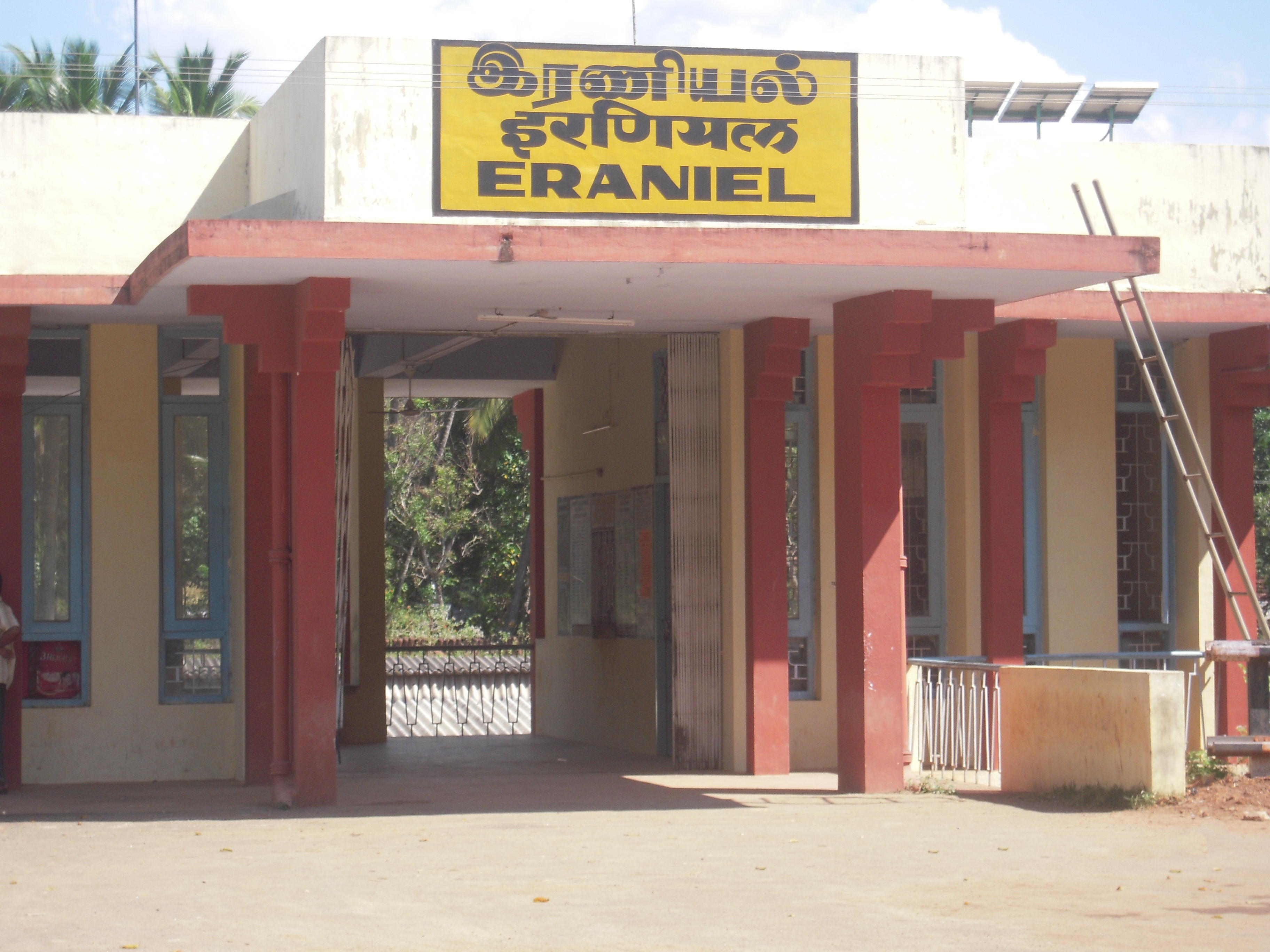
[[Eraniel railway station]] is the nearest railway station. The station has two platforms and falls on the [[Kanyakumari]]–[[Thiruvananthapuram]] line in the Thiruvananthapuram division of the [[Southern Railway zone]].<ref name="parliamentofindia.nic.in">{{Cite web |url=http://parliamentofindia.nic.in/lsdeb/ls11/ses2/1225079605.htm |title=XI LOK SABHA DEBATES Session II, Budget Thursday, 25 July 1996/Sravana 3, 1918 (Saka) |access-date=3 September 2015 |archive-url=https://web.archive.org/web/20160304053744/http://parliamentofindia.nic.in/lsdeb/ls11/ses2/1225079605.htm |archive-date=4 March 2016 |url-status=dead }}</ref> All daily trains passing through the station | [[Eraniel railway station]] is the nearest railway station. The station has two platforms and falls on the [[Kanyakumari]]–[[Thiruvananthapuram]] line in the Thiruvananthapuram division of the [[Southern Railway zone]].<ref name="parliamentofindia.nic.in">{{Cite web |url=http://parliamentofindia.nic.in/lsdeb/ls11/ses2/1225079605.htm |title=XI LOK SABHA DEBATES Session II, Budget Thursday, 25 July 1996/Sravana 3, 1918 (Saka) |access-date=3 September 2015 |archive-url=https://web.archive.org/web/20160304053744/http://parliamentofindia.nic.in/lsdeb/ls11/ses2/1225079605.htm |archive-date=4 March 2016 |url-status=dead }}</ref> All daily trains passing through the station halt in Eraniel station.<ref name="parliamentofindia.nic.in"/> The route from Eraniel to [[Thiruvananthapuram]] runs through tunnels and hilly terrains. It takes one hour from Thiruvananthapuram to Eraniel by train. The [[Mondaicaud Bhagavathi Temple|Mandaikadu Bagavathi Amman Temple]], [[Kolachal]] Port, I.R.E Industries in Manavalakurichi and [[Padmanabhapuram Palace]] are situated nearby the station.<ref name="parliamentofindia.nic.in"/> The station also is the nearest railhead for two municipalities – Padmanabapuram, Colachel and for 25 villages. | ||
==Air== | ==Air== | ||
[[File:Departures terminal Trivandrum International Airport Kerala India.jpg|thumb|right|200px|[[Trivandrum International Airport|Thiruvananthapuram International Airport]]]] | [[File:Departures terminal Trivandrum International Airport Kerala India.jpg|thumb|right|200px|[[Trivandrum International Airport|Thiruvananthapuram International Airport]]]] | ||
The nearest international airport is [[Trivandrum International Airport|Thiruvananthapuram International Airport]] . [[Thiruvananthapuram]] connects the town further to other major cities like [[Bangalore]], [[Mumbai]], [[Cochin]], [[Delhi]], [[Goa]], and [[Chennai]] | The nearest international airport is [[Trivandrum International Airport|Thiruvananthapuram International Airport]]. [[Thiruvananthapuram]] connects the town further to other major cities like [[Bangalore]], [[Mumbai]], [[Cochin]], [[Delhi]], [[Goa]], and [[Chennai]]. | ||
==Demographics== | ==Demographics== | ||
| Line 87: | Line 80: | ||
==References== | ==References== | ||
<references/> | <references/> | ||
[[Category:Cities and towns in Kanyakumari district]] | [[Category:Cities and towns in Kanyakumari district]] | ||
Latest revision as of 10:34, 16 June 2023
Manavalakurichi | |
|---|---|
Town | |
| Nickname: Manavai | |
  Manavalakurichi Location in Tamil Nadu, India | |
| Coordinates: 8°08′N 77°18′E / 8.13°N 77.3°E | |
| Country |  India India |
| State | Tamil Nadu |
| District | Kanniyakumari |
| Elevation | 0 m (0 ft) |
| Population (2011) | |
| • Total | 10,969 |
| Languages | |
| • Official | Tamil |
| Time zone | UTC+5:30 (IST) |
| Postal code | 629252 |
Manavalakurichi is a panchayat town in Kanniyakumari district in the Indian state of Tamil Nadu. It is hardly 60 km from Thiruvananthapuram, the capital city of Kerala. Tamil and Malayalam are the common languages of people living here.
Manavalakurichi has an average elevation of 0 metres (0 ft)).
Sea ports[edit | edit source]

Jeppiaar Fishing Harbour in Muttom[1] is the nearest sea port. This is a private sea port and was built by educationalist and business man Jeppiaar.
Another near sea port is Kolachal. It is an ancient port, aging back to 18th century. Vasco da Gama called it "Colachi". After the defeat of the Dutch by King Anizham Thirunal Marthanda Varma in Battle of Colachel on 10 August 1741, a victory pillar had been erected near the beach in commemoration of the victory.
Roads[edit | edit source]
The town is well connected to all parts of the state through road. Nagercoil, the district headquarters of Kanyakumari, is situated 20 km from Manavalakurichi in the north-east direction. Direct bus service from Manavalakurichi is available to Thiruvananthapuram the capital city of Kerala. This journey usually takes less than two hours. Frequent bus service to Thuckalay, another town which is 11 km away, is also available.
Rail[edit | edit source]

Eraniel railway station is the nearest railway station. The station has two platforms and falls on the Kanyakumari–Thiruvananthapuram line in the Thiruvananthapuram division of the Southern Railway zone.[2] All daily trains passing through the station halt in Eraniel station.[2] The route from Eraniel to Thiruvananthapuram runs through tunnels and hilly terrains. It takes one hour from Thiruvananthapuram to Eraniel by train. The Mandaikadu Bagavathi Amman Temple, Kolachal Port, I.R.E Industries in Manavalakurichi and Padmanabhapuram Palace are situated nearby the station.[2] The station also is the nearest railhead for two municipalities – Padmanabapuram, Colachel and for 25 villages.
Air[edit | edit source]

The nearest international airport is Thiruvananthapuram International Airport. Thiruvananthapuram connects the town further to other major cities like Bangalore, Mumbai, Cochin, Delhi, Goa, and Chennai.
Demographics[edit | edit source]
As of 2011[update] India census,[3] had a total population of 10,969 with males 5478 marginally less over females 5491. Manavalakurichi has an average literacy rate of 79%, higher than the national average of 59.5%: male literacy is 81%, and female literacy is 77%. In Manavalakurichi, 11% of the population is under 6 years of age.
References[edit | edit source]
- ↑ "Jeppiaar Fishing Harbour Muttom Private Limited". CorporateDir. Retrieved 13 June 2018.
- ↑ 2.0 2.1 2.2 "XI LOK SABHA DEBATES Session II, Budget Thursday, 25 July 1996/Sravana 3, 1918 (Saka)". Archived from the original on 4 March 2016. Retrieved 3 September 2015.
- ↑ "Census of India 2001: District Census Hand Book". Census Commission of India.