



imported>BattyBot m Removed/fixed incorrect author parameter(s), performed general fixes |
robot: Update article (please report if you notice any mistake or error in this edit) |
||
| Line 1: | Line 1: | ||
{{Use Indian English|date=September 2016}} | {{Use Indian English|date=September 2016}} | ||
{{Use dmy dates|date=September 2016}} | {{Use dmy dates|date=September 2016}} | ||
| Line 47: | Line 46: | ||
}} | }} | ||
'''Yingkiong''' is a town and the administrative | '''Yingkiong''' is a town in and the administrative headquarters of [[Upper Siang district]] in the [[Northeast India]]n state of [[Arunachal Pradesh]].<ref>{{Cite web|url=http://districts.nic.in/districtsdetails.php?sid=AR&disid=AR010|title=Upper Siang {{!}} Arunachal Pradesh {{!}} DISTRICTS OF INDIA|website=districts.nic.in|language=EN|access-date=2018-09-19}}</ref> It is located {{Convert|250|km|mi|abbr=}} north of [[Itanagar]], the capital of the state,<ref name=":0">{{Cite web |url=http://dcmsme.gov.in/dips/Dist-Profile-Upper-Siang.pdf |title=Archived copy |access-date=21 September 2018 |archive-date=8 April 2015 |archive-url=https://web.archive.org/web/20150408054958/http://dcmsme.gov.in/dips/Dist-Profile-Upper-Siang.pdf |url-status=dead }}</ref> and {{Convert|1|km|mile}} east of the [[Brahmaputra River|River Siang]].<ref>{{Cite web|url=https://www.google.com/maps/dir/28.6410969,95.0176618/28.6402864,95.0261974/@28.6419987,95.0206179,17z/am=t?shorturl=1|title=Unnamed Road to Unnamed Road|website=Unnamed Road to Unnamed Road|language=en|access-date=2019-06-14}}</ref> According to the [[2011 Census of India|2011 Census]], the town has a total population of 8,573.<ref>{{Cite web|url=http://censusindia.gov.in/pca/SearchDetails.aspx?Id=298497|title=Census, Govt of India - Yingkiong|year=2011}}</ref> | ||
== History == | ==History== | ||
[[File:North-East Frontier in 1946 map of India by National Geographic.jpg|thumb|left|250px|Map of the North-East Frontier Tracts in 1946; Yinkiong was in the Sadiya Frontier Tract]] | |||
In 1911, following the Anglo–Abor wars, the British gained administrative control of the [[Upper Siang district|Upper Siang]] region. It was put under the administrative control of the Assistant Political Officer stationed at [[Sadiya]] (in Assam) during the period. Some notable British civil servants who held the role of Assistant Political Officer included [[Jack Francis Needham]], appointed in 1882,<ref>{{Cite book|url=https://books.google.com/books?id=pL_GfLfK3lYC&q=francis&pg=PA52|title=Report on the Administration of North East India|date=1984|publisher=Mittal Publications|language=en}}</ref> and [[Noel Williamson]], who was assassinated by the villagers of Komsing in the present day [[East Siang district]].<ref>{{Cite web|url=https://www.telegraphindia.com/states/north-east/forgotten-fighter-of-arunachal-work-on-promised-memorial-yet-to-begin/cid/272232|title=Forgotten fighter of Arunachal - Work on promised memorial yet to begin|website=www.telegraphindia.com|language=en|access-date=2019-06-26}}</ref><ref>{{Cite web|url=https://thenortheasttoday.com/archive/northeast-indias-5-unforgettable-freedom-fighters/|title=Northeast India's 5 unforgettable freedom fighters|website=TNT-The NorthEast Today|language=en-US|access-date=2019-06-26|archive-date=26 June 2019|archive-url=https://web.archive.org/web/20190626094015/https://thenortheasttoday.com/archive/northeast-indias-5-unforgettable-freedom-fighters/|url-status=dead}}</ref> | |||
[[ | After the independence of India, the region was part of the East Siang district until 1995, when it was separated for administrative convenience and made an independent district, northwest of [[Pasighat]].<ref>{{Cite web|title=Pasighat to Yingkiong|url=https://www.google.com/maps/dir/Pasighat,+791102/Yingkiong+791002/@28.4287891,94.8048081,9.25z/data=!4m13!4m12!1m5!1m1!1s0x373f96c3a0c72f09:0x2a6b8445d41d326c!2m2!1d95.3259629!2d28.0618646!1m5!1m1!1s0x376aab0ed1e62679:0x4a2c26f253a3cdef!2m2!1d95.0364522!2d28.6235847|access-date=2020-08-22|website=Pasighat to Yingkiong|language=en}}</ref> | ||
== Geography == | ==Geography== | ||
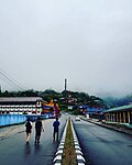
[[File:Yingkiong Town.jpg|thumb|View of ([[National Highway 513 (India)|NH-513]]) Yingkiong]] | |||
Yingkiong is characterised by its hilly terrains and river valleys.<ref>{{cite web |url=http://cgwb.gov.in/District_Profile/Arunachal/UPPER%20SIANG.pdf |title=Ground Water Information Booklet. Upper Siang District, Arunachal Pradesh |date=September 2013}}</ref> The town is {{cvt|200|m|ft}} above sea level. [[Tuting]], Singging, and [[Bishing]] are towns north of Yingkiong, geographically close to the Indo-China border. Simong, Gobuk, [[Puging]], Pangkang, Gette, Moying, Bomdo, Likor, and [[Millang]] are some of the villages and hamlets that surround Yingkiong.{{Citation needed|date=January 2022}} | |||
== Climate == | ==Climate== | ||
Yingkiong has a relatively warm and humid [[Subtropics|subtropical]] climate. The highest recorded temperature in Yingkiong is 39 °C during summer, and 4 °C in winter.<ref name="cgwb.gov.in">http://cgwb.gov.in/District_Profile/Arunachal/UPPER%20SIANG.pdf</ref> The highest recorded annual rainfall of Yingkiong is | Yingkiong has a relatively warm and humid [[Subtropics|subtropical]] climate. The highest recorded temperature in Yingkiong is 39 °C during summer, and 4 °C in winter.<ref name="cgwb.gov.in">http://cgwb.gov.in/District_Profile/Arunachal/UPPER%20SIANG.pdf {{Bare URL PDF|date=March 2022}}</ref> The highest recorded annual rainfall of Yingkiong is 3,116 mm.<ref>{{Cite book|title=Managing natural resources : focus on land and water : felicitation volume in honour of Professor R.L. Dwivedi|others=Dwivedi, R. L., 1924-, Misra, H. N. (Harikesh N.), 1945-|isbn=9788120349339|location=Delhi|oclc=893309586|date = 13 March 2014}}</ref> The higher parts of the town receive snowfall for most of the year. | ||
[[File:Snow_in_upper_Yingkiong_.jpg|thumb|Villagers trekking to upper region of Yingkiong town covered with snow for a major period of the year.]] | [[File:Snow_in_upper_Yingkiong_.jpg|thumb|Villagers trekking to upper region of Yingkiong town covered with snow for a major period of the year.]] | ||
== Economy == | ==Economy== | ||
The majority of Yingkiong | The majority of Yingkiong people are [[subsistence farmers]]. Fruit and vegetable cultivation for commercial sale is endorsed by local administration through MIDH (Mission For Integrated Development of Horticulture), a centrally-sponsored scheme of the [[Ministry of Agriculture and Farmers' Welfare]].<ref>{{Cite web|title=Horticulture {{!}} DISTRICT UPPER SIANG {{!}} India|url=https://uppersiang.nic.in/horticulture/|access-date=2020-10-11|language=en-US}}</ref><ref>{{Cite web|title=Home {{!}} Mission for Integrated Development of Horticulture (MIDH)|url=https://midh.gov.in/|access-date=2020-10-11|website=midh.gov.in}}</ref> Of the 69 per cent of households engaged in agriculture in Upper Siang, the Yingkiong township has the highest number of urban agrarian households.<ref name="cgwb.gov.in"/> | ||
[[Jhum|Jhum cultivation]] (slash and burn) and [[Terrace (earthworks)|terrace farming]] are the most common farming techniques. Rice, [[maize]], and [[millet]] are the main food crops. Cash crops like turmeric and [[sugarcane]] are commonly grown.<ref>{{Cite web|url=http://agricoop.nic.in/agriculturecontingency/arunachal-pradesh?page=1|title=ARUNACHAL PRADESH {{!}} Department of Agriculture Cooperation & Farmers Welfare {{!}} Mo A&FW {{!}} GoI|website=agricoop.nic.in|access-date=2019-02-13}}</ref> | |||
Cultivation of seasonal fruits like oranges and pineapple is common, and during periods of favourable cultivation and surplus output, they are transported in bulk for sale in local markets or outside the town in Pasighat. [[Fish farming|Pisciculture]] is also common and is promoted under a centrally sponsored FFDA (Fish Farmer Development Agency) programme to generate employment for locals and revenue for the state.<ref>{{Cite web|url=http://meenarun.nic.in/schemes.html|title=Department of Fisheries {{!}} Arunachal Pradesh|website=meenarun.nic.in|access-date=2019-02-13}}</ref> | |||
{| | A variety of [[black tea]] called Siang Tea<ref>{{Cite web|title=SIANG TEA AND INDUSTRIES PVT LTD - Company, directors and contact details {{!}} Zauba Corp|url=https://www.zaubacorp.com/company/SIANG-TEA-AND-INDUSTRIES-PVT-LTD/U01132AR1986PTC002622|access-date=2018-09-19|website=www.zaubacorp.com|language=en}}</ref> is made at the Deki Tea estate in Ramsing Village for export and domestic consumption.<ref>{{Cite web |url=http://www.mospi.gov.in/sites/default/files/6ec_dirEst/ec6_Arunachal%20Pradesh.pdf |title=Archived copy |access-date=26 June 2019 |archive-date=13 November 2019 |archive-url=https://web.archive.org/web/20191113001327/http://www.mospi.gov.in/sites/default/files/6ec_dirEst/ec6_Arunachal%20Pradesh.pdf |url-status=dead }}</ref> | ||
| | |||
| | |||
| | |||
| | |||
| | |||
| | |||
| | |||
| | |||
| | |||
|- | |||
== | Handicrafts such as woven bamboo stools known as ''murha'' are often seen. The [[Adi people|Adi tribe]] are known for making a distinct type of traditional basket called ''egin'', which is used frequently by the locals to carry household items like rice, dried wood, and other edibles or farm products.<ref>{{Cite journal|last=Sharma|first=Tika Prasad|date=October 2008|title=Ethnobotanical observations on Bamboos among Adi tribes in Arunachal Pradesh|url=http://www.niscair.res.in/sciencecommunication/researchjournals/rejour/ijtk/fulltextsearch/2008/October%202008/IJTK-Vol%207(4)-%20October%202008-%20pp%20594-597.htm|journal=Indian Journal of Traditional Knowledge|volume= 7|issue=4|pages=594–597|via=Department of Botany, Gauhati University, Guwahati 781014, Assam}}</ref> | ||
=== | |||
The | ==Demographics== | ||
According to the [[2011 Census of India]], the town had a total population of 8,573: there were 4,381 males and 4,192 females. There were 1,139 persons aged 0 to 6. The total working population was 3,787, with the male working population at 2,221 and the female working population at 1,566.<ref>{{Cite web|url=http://censusindia.gov.in/pca|title=Census of India: Primary Census Abstract|website=censusindia.gov.in|access-date=2018-09-19}}</ref> It has a non-working population of 4,786 persons, mostly of dependent age. | |||
The literacy rate of the region is 64%. The female literacy rate is 44.89% and the male literacy rate is 55%.<ref>{{Cite web|url=http://censusindia.gov.in/pca/SearchDetails.aspx?Id=298497|title=Census of India: Search Details|website=censusindia.gov.in|access-date=2019-06-09}}</ref> | |||
= | [[Adi language|Adi]] is the primary [[dialect]] spoken in the area. [[Hindi]] is commonly used as a [[lingua franca]].{{Citation needed|date=January 2022}} | ||
The | ==Culture== | ||
===Festivals=== | |||
The locals of Yingkiong celebrate the Solung,<ref>{{Cite web|url=https://arunachaltimes.in/index.php/2018/09/03/cs-visits-upper-siang-attends-solung-festival/|title=CS visits Upper Siang, attends Solung festival |website= The Arunachal Times |language=en-US|access-date=2018-09-19}}</ref> Aran (Unying-Aran), Etor,<ref name="Mishra 2016">{{cite journal |last1=Mishra |first1=B.P. |last2=Kumawat |first2=M.M. |last3=Kumar |first3=Naresh |last4=Riba |first4=Toge |last5=Kumar |first5=Sanjeev |title=Significance of Aran Festival for Rodent Management by Adi Tribes of Arunachal Pradesh |journal=Journal of Global Communication |date=2016 |volume=9 |issue=1 |pages=15 |doi=10.5958/0976-2442.2016.00004.5 |issn=0974-0600}}</ref> Siang River Darshan, and [[Mopin]] festivals. | |||
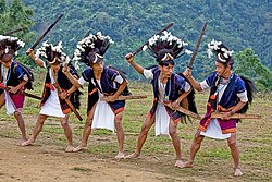
[[File:Tapu War dance.jpg|thumb|Tapu (a typical aggressive posturing by male members of Adi tribe) during Aran festival staging the war cry dance during actual tribe wars done as a 'warm up' before the real armed conflict.]] | |||
[[File:Siang River Festival,Upper Siang.jpg|thumb|Tribal women performing traditional welcome dance (Ponung) as a part of Siang River festival.]] | |||
*The Solung festival revolves around agriculture and celebrates good harvest. The festival is generally celebrated mid-August–September: a proper date for the festival is fixed by a village council called the ''kebang''<ref name="cgwb.gov.in" /> or by the ''gam'' (village headman) each year. On the day of the festival , villagers prepare [[Apo (drink)|''apong (local rice wine)'']]. Fresh vegetables and meats are stored for the occasion. | |||
*Aran (Unying Aran) is a new year festival of the Adi community celebrated in the districts of East and Upper Siang.<ref>{{Cite web|url=https://arunachaltimes.in/index.php/2018/03/09/unying-aran-celebrated-with-traditional-fervor/|title=Unying Aran celebrated with traditional fervor |website= Arunachal Times |access-date=2018-09-19}}</ref> It marks the arrival of the [[Spring (season)|spring]]. During the festival, male elders of the village perform the Bari dance, and young boys and girls perform the Yakjong dance, which narrate the origins of the festival. They also pray for the good health and prosperity of the people. | |||
*The Etor festival is celebrated on May 15 by Adi tribes in East and Upper Siang. Etor means 'fencing' in local dialect and therefore it is related to the protection of crops by fencing the cultivated lands and protecting [[gayal]] (Mithun) inside large fields.<ref>{{Cite book |title=Cultural fiesta in the "Island of peace" Arunachal Pradesh|last1=Pathak |first1=Guptajit |date=2008|publisher=Mittal Publications|last2=Gogoi |first2=Raju|isbn=978-8183242318|location=New Delhi, India|oclc=277280040}}</ref> A huge feast is held and offerings are made to deities. Etor marks the beginning of the annual agricultural cycle of the community.<ref name="Mishra 2016" /> | |||
*The Siang River festival was previously known as the Brahmaputra Darshan Festival. After 2005, Yingkiong, Tuting, and Pasighat were chosen as the places to conduct the festival.<ref>{{Cite news|url=https://www.nelive.in/arunachal-pradesh/art-culture/famous-festivals-arunachal-pradesh|title=Famous Festivals Of Arunachal Pradesh|date=2018-07-04|work=Nelive|access-date=2018-09-19|archive-date=19 September 2018|archive-url=https://web.archive.org/web/20180919171802/https://www.nelive.in/arunachal-pradesh/art-culture/famous-festivals-arunachal-pradesh|url-status=dead}}</ref> | |||
==Transport== | |||
The town is connected to the rest of the country and Arunachal Pradesh via [[National Highway 513 (India)|National Highway 513]] (NH-513) and NH-52 from Pasighat (126 km) to [[Itanagar]] (392 km). Modes of transport include taxi and Arunachal Pradesh State Transport bus services.<ref name=tr1/> | |||
In January 2019, Byorung Bridge, a 300-meter long [[Cable-stayed bridge|cable stayed suspension foot-bridge]], was constructed over the [[Brahmaputra River|Siang river]] . The bridge connects the town of Tuting on the eastern bank to the road to Tuting-Gelling on the western bank, reducing 40 km in travel distance for 20,000 residents of nearby villages.<ref>[https://www.deccanherald.com/national/longest-suspension-bridge-near-712412.html Longest suspension bridge near China border], Deccan Derald, 11 jan 2019.</ref> | |||
The nearest railway station is 165 km south at [[Murkongselek railway station|Murkongselek]] in the [[Jonai]] District of Assam | Earlier aerial connectivity was limited to [[Mohanbari Airport]] in Dibrugarh.<ref name=tr1>{{Cite web|url=https://www.google.com/maps/dir/Dibrugarh+Airport,+Mohanbari,+Assam+786012/Yingkiong,+791002/@27.9968961,94.4623071,9z/am=t/data=!3m1!4b1!4m14!4m13!1m5!1m1!1s0x37409f0a988ccddb:0x52d3689326f31d52!2m2!1d95.0159356!2d27.485766!1m5!1m1!1s0x376aab0ed1e62679:0x4a2c26f253a3cdef!2m2!1d95.0364522!2d28.6235847!3e0?shorturl=1|title=Dibrugarh Airport to Yingkiong|website=Dibrugarh Airport to Yingkiong|language=en|access-date=2019-06-09}}</ref><ref>{{Cite web|url=https://www.telegraphindia.com/states/north-east/aai-sees-potential-in-dibrugarh-airport/cid/1416205|title=AAI sees potential in Dibrugarh airport|website=www.telegraphindia.com|language=en|access-date=2019-06-09}}</ref> In 2018, [[Pasighat Airport]] was built and made operational in Pasighat town,<ref>{{Cite news|url=https://timesofindia.indiatimes.com/city/itanagar/arunachals-first-commercial-flight-lands-at-pasighat-airport/articleshow/64271968.cms|title=Arunachal's first commercial flight lands at Pasighat airport - Times of India|work=The Times of India|access-date=2018-09-19}}</ref> which is currently the nearest airport to reach Yingkiong. There is direct aerial connectivity to Yingkiong through the helicopter services that are available from Pasighat, Itanagar, and Assam.<ref>{{Cite web|url=http://www.arunachalpradesh.gov.in/civil-aviation/|title=Civil Aviation – Government of Arunachal Pradesh|website=www.arunachalpradesh.gov.in|language=en-US|access-date=2018-09-19}}</ref> There are two [[heliport]]s in the town: one near Siang and the other across from the District Collector office in Yingkiong that facilitates helicopter landing services.<ref>{{Cite web|url=https://www.google.com/maps/place/Helipad+Yingkiong/@28.6333039,95.0233992,17z/data=!4m5!3m4!1s0x376aab2b3b122a25:0x9816f9f9d8ae834c!8m2!3d28.6333039!4d95.0255879?shorturl=1|title=Helipad Yingkiong|website=Helipad Yingkiong|language=en|access-date=2019-06-09}}</ref> | ||
The nearest railway station is 165 km south at [[Murkongselek railway station|Murkongselek]] in the [[Jonai]] District of Assam,<ref>{{Cite web|url=https://indiarailinfo.com/departures/murkongselek-mzs/872|title=Murkongselek Station - 3 Train Departures NFR/Northeast Frontier Zone - Railway Enquiry|last=Shah|first=Jay|website=indiarailinfo.com|access-date=2018-09-20}}</ref> connecting Yingkiong via Pasighat.<ref>{{Cite web|url=http://www.assamtribune.com/scripts/details.asp?id=jan2510/State10|title=The Assam Tribune Online|last=Trade|first=TI|website=www.assamtribune.com|access-date=2018-09-20|archive-date=20 September 2018|archive-url=https://web.archive.org/web/20180920161229/http://www.assamtribune.com/scripts/details.asp?id=jan2510%2FState10|url-status=dead}}</ref> | |||
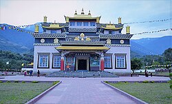
[[File:Tuting monastery -.jpg|thumb|Palyul Monastery in Upper Siang|alt=]] | [[File:Tuting monastery -.jpg|thumb|Palyul Monastery in Upper Siang|alt=]] | ||
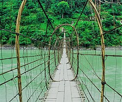
[[File:Gandhi bridge.jpg|thumb|220x220px|Gandhi Bridge( a makeshift swinging bridge) over the Siang river, made of cane and bamboo. | [[File:Gandhi bridge.jpg|thumb|220x220px|Gandhi Bridge (a makeshift swinging bridge) over the Siang river, made of cane and bamboo. It is a major tourist attraction across Siang river.]] | ||
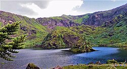
[[File:TsitA.jpg|thumb|View of sacred Tsitapuri Lake in Upper Siang]] | |||
== | ==COVID-19== | ||
The town has confirmed multiple cases of [[COVID-19]]. Among them was a student returnee from the [[National Capital Region (India)|National Capital Region]] and the Health and Family Welfare Minister of Arunachal Pradesh who is a native of Yingkiong. The town does not have a COVID-19 testing lab facility.<ref>{{Cite web|date=2020-05-31|title=Arunachal Pradesh reports fourth COVID-19 case|url=https://www.deccanherald.com/national/east-and-northeast/arunachal-pradesh-reports-fourth-covid-19-case-843869.html|access-date=2020-09-15|website=Deccan Herald|language=en}}</ref><ref>{{Cite web|last=Desk|first=Sentinel Digital|date=2020-09-15|title=Arunachal Health & Family Welfare Minister Alo Libang tests COVID positive - Sentinelassam|url=https://www.sentinelassam.com/north-east-india-news/arunachal-news/arunachal-health-family-welfare-minister-alo-libang-tests-covid-positive-501494|access-date=2020-09-15|website=www.sentinelassam.com|language=en}}</ref> | |||
== | ==Notable people== | ||
* [[ | * [[Gegong Apang]] | ||
* [[ | * [[Alo Libang]] | ||
== References == | ==References== | ||
{{Reflist}} | {{Reflist}} | ||
== External links == | ==External links== | ||
* https://uppersiang.nic.in/ | *https://uppersiang.nic.in/ | ||
* http://arunachaltp.nic.in/yingkiong.html | *http://arunachaltp.nic.in/yingkiong.html | ||
[[Category:Cities and towns in Upper Siang district]] | [[Category:Cities and towns in Upper Siang district]] | ||
Latest revision as of 18:36, 14 March 2022
Yingkiong | |
|---|---|
Town | |
 Welcome Gate,Yingkiong | |
  Yingkiong Location in Arunachal Pradesh, India  Yingkiong Yingkiong (India) | |
| Coordinates: 28°36′37″N 95°02′51″E / 28.61037°N 95.047531°E | |
| Country |  India India |
| State | Arunachal Pradesh |
| Elevation | 200 m (700 ft) |
| Population (2011 Census) | |
| • Total | 8,573 |
| Time zone | UTC+5:30 (IST) |
| Vehicle registration | AR-14 |
| Website | https://uppersiang.nic.in/ |
Yingkiong is a town in and the administrative headquarters of Upper Siang district in the Northeast Indian state of Arunachal Pradesh.[1] It is located 250 kilometres (160 mi) north of Itanagar, the capital of the state,[2] and 1 kilometre (0.62 mi) east of the River Siang.[3] According to the 2011 Census, the town has a total population of 8,573.[4]
History[edit | edit source]

In 1911, following the Anglo–Abor wars, the British gained administrative control of the Upper Siang region. It was put under the administrative control of the Assistant Political Officer stationed at Sadiya (in Assam) during the period. Some notable British civil servants who held the role of Assistant Political Officer included Jack Francis Needham, appointed in 1882,[5] and Noel Williamson, who was assassinated by the villagers of Komsing in the present day East Siang district.[6][7]
After the independence of India, the region was part of the East Siang district until 1995, when it was separated for administrative convenience and made an independent district, northwest of Pasighat.[8]
Geography[edit | edit source]

Yingkiong is characterised by its hilly terrains and river valleys.[9] The town is 200 m (660 ft) above sea level. Tuting, Singging, and Bishing are towns north of Yingkiong, geographically close to the Indo-China border. Simong, Gobuk, Puging, Pangkang, Gette, Moying, Bomdo, Likor, and Millang are some of the villages and hamlets that surround Yingkiong.[citation needed]
Climate[edit | edit source]
Yingkiong has a relatively warm and humid subtropical climate. The highest recorded temperature in Yingkiong is 39 °C during summer, and 4 °C in winter.[10] The highest recorded annual rainfall of Yingkiong is 3,116 mm.[11] The higher parts of the town receive snowfall for most of the year.

Economy[edit | edit source]
The majority of Yingkiong people are subsistence farmers. Fruit and vegetable cultivation for commercial sale is endorsed by local administration through MIDH (Mission For Integrated Development of Horticulture), a centrally-sponsored scheme of the Ministry of Agriculture and Farmers' Welfare.[12][13] Of the 69 per cent of households engaged in agriculture in Upper Siang, the Yingkiong township has the highest number of urban agrarian households.[10]
Jhum cultivation (slash and burn) and terrace farming are the most common farming techniques. Rice, maize, and millet are the main food crops. Cash crops like turmeric and sugarcane are commonly grown.[14]
Cultivation of seasonal fruits like oranges and pineapple is common, and during periods of favourable cultivation and surplus output, they are transported in bulk for sale in local markets or outside the town in Pasighat. Pisciculture is also common and is promoted under a centrally sponsored FFDA (Fish Farmer Development Agency) programme to generate employment for locals and revenue for the state.[15]
A variety of black tea called Siang Tea[16] is made at the Deki Tea estate in Ramsing Village for export and domestic consumption.[17]
Handicrafts such as woven bamboo stools known as murha are often seen. The Adi tribe are known for making a distinct type of traditional basket called egin, which is used frequently by the locals to carry household items like rice, dried wood, and other edibles or farm products.[18]
Demographics[edit | edit source]
According to the 2011 Census of India, the town had a total population of 8,573: there were 4,381 males and 4,192 females. There were 1,139 persons aged 0 to 6. The total working population was 3,787, with the male working population at 2,221 and the female working population at 1,566.[19] It has a non-working population of 4,786 persons, mostly of dependent age.
The literacy rate of the region is 64%. The female literacy rate is 44.89% and the male literacy rate is 55%.[20]
Adi is the primary dialect spoken in the area. Hindi is commonly used as a lingua franca.[citation needed]
Culture[edit | edit source]
Festivals[edit | edit source]
The locals of Yingkiong celebrate the Solung,[21] Aran (Unying-Aran), Etor,[22] Siang River Darshan, and Mopin festivals.


- The Solung festival revolves around agriculture and celebrates good harvest. The festival is generally celebrated mid-August–September: a proper date for the festival is fixed by a village council called the kebang[10] or by the gam (village headman) each year. On the day of the festival , villagers prepare apong (local rice wine). Fresh vegetables and meats are stored for the occasion.
- Aran (Unying Aran) is a new year festival of the Adi community celebrated in the districts of East and Upper Siang.[23] It marks the arrival of the spring. During the festival, male elders of the village perform the Bari dance, and young boys and girls perform the Yakjong dance, which narrate the origins of the festival. They also pray for the good health and prosperity of the people.
- The Etor festival is celebrated on May 15 by Adi tribes in East and Upper Siang. Etor means 'fencing' in local dialect and therefore it is related to the protection of crops by fencing the cultivated lands and protecting gayal (Mithun) inside large fields.[24] A huge feast is held and offerings are made to deities. Etor marks the beginning of the annual agricultural cycle of the community.[22]
- The Siang River festival was previously known as the Brahmaputra Darshan Festival. After 2005, Yingkiong, Tuting, and Pasighat were chosen as the places to conduct the festival.[25]
Transport[edit | edit source]
The town is connected to the rest of the country and Arunachal Pradesh via National Highway 513 (NH-513) and NH-52 from Pasighat (126 km) to Itanagar (392 km). Modes of transport include taxi and Arunachal Pradesh State Transport bus services.[26]
In January 2019, Byorung Bridge, a 300-meter long cable stayed suspension foot-bridge, was constructed over the Siang river . The bridge connects the town of Tuting on the eastern bank to the road to Tuting-Gelling on the western bank, reducing 40 km in travel distance for 20,000 residents of nearby villages.[27]
Earlier aerial connectivity was limited to Mohanbari Airport in Dibrugarh.[26][28] In 2018, Pasighat Airport was built and made operational in Pasighat town,[29] which is currently the nearest airport to reach Yingkiong. There is direct aerial connectivity to Yingkiong through the helicopter services that are available from Pasighat, Itanagar, and Assam.[30] There are two heliports in the town: one near Siang and the other across from the District Collector office in Yingkiong that facilitates helicopter landing services.[31]
The nearest railway station is 165 km south at Murkongselek in the Jonai District of Assam,[32] connecting Yingkiong via Pasighat.[33]


COVID-19[edit | edit source]
The town has confirmed multiple cases of COVID-19. Among them was a student returnee from the National Capital Region and the Health and Family Welfare Minister of Arunachal Pradesh who is a native of Yingkiong. The town does not have a COVID-19 testing lab facility.[34][35]
Notable people[edit | edit source]
References[edit | edit source]
- ↑ "Upper Siang | Arunachal Pradesh | DISTRICTS OF INDIA". districts.nic.in. Retrieved 19 September 2018.
- ↑ "Archived copy" (PDF). Archived from the original (PDF) on 8 April 2015. Retrieved 21 September 2018.
{{cite web}}: CS1 maint: archived copy as title (link) - ↑ "Unnamed Road to Unnamed Road". Unnamed Road to Unnamed Road. Retrieved 14 June 2019.
- ↑ "Census, Govt of India - Yingkiong". 2011.
- ↑ Report on the Administration of North East India. Mittal Publications. 1984.
- ↑ "Forgotten fighter of Arunachal - Work on promised memorial yet to begin". www.telegraphindia.com. Retrieved 26 June 2019.
- ↑ "Northeast India's 5 unforgettable freedom fighters". TNT-The NorthEast Today. Archived from the original on 26 June 2019. Retrieved 26 June 2019.
- ↑ "Pasighat to Yingkiong". Pasighat to Yingkiong. Retrieved 22 August 2020.
- ↑ "Ground Water Information Booklet. Upper Siang District, Arunachal Pradesh" (PDF). September 2013.
- ↑ 10.0 10.1 10.2 http://cgwb.gov.in/District_Profile/Arunachal/UPPER%20SIANG.pdf [bare URL PDF]
- ↑ Managing natural resources : focus on land and water : felicitation volume in honour of Professor R.L. Dwivedi. Dwivedi, R. L., 1924-, Misra, H. N. (Harikesh N.), 1945-. Delhi. 13 March 2014. ISBN 9788120349339. OCLC 893309586.
{{cite book}}: CS1 maint: location missing publisher (link) CS1 maint: others (link) - ↑ "Horticulture | DISTRICT UPPER SIANG | India". Retrieved 11 October 2020.
- ↑ "Home | Mission for Integrated Development of Horticulture (MIDH)". midh.gov.in. Retrieved 11 October 2020.
- ↑ "ARUNACHAL PRADESH | Department of Agriculture Cooperation & Farmers Welfare | Mo A&FW | GoI". agricoop.nic.in. Retrieved 13 February 2019.
- ↑ "Department of Fisheries | Arunachal Pradesh". meenarun.nic.in. Retrieved 13 February 2019.
- ↑ "SIANG TEA AND INDUSTRIES PVT LTD - Company, directors and contact details | Zauba Corp". www.zaubacorp.com. Retrieved 19 September 2018.
- ↑ "Archived copy" (PDF). Archived from the original (PDF) on 13 November 2019. Retrieved 26 June 2019.
{{cite web}}: CS1 maint: archived copy as title (link) - ↑ Sharma, Tika Prasad (October 2008). "Ethnobotanical observations on Bamboos among Adi tribes in Arunachal Pradesh". Indian Journal of Traditional Knowledge. 7 (4): 594–597 – via Department of Botany, Gauhati University, Guwahati 781014, Assam.
- ↑ "Census of India: Primary Census Abstract". censusindia.gov.in. Retrieved 19 September 2018.
- ↑ "Census of India: Search Details". censusindia.gov.in. Retrieved 9 June 2019.
- ↑ "CS visits Upper Siang, attends Solung festival". The Arunachal Times. Retrieved 19 September 2018.
- ↑ 22.0 22.1 Mishra, B.P.; Kumawat, M.M.; Kumar, Naresh; Riba, Toge; Kumar, Sanjeev (2016). "Significance of Aran Festival for Rodent Management by Adi Tribes of Arunachal Pradesh". Journal of Global Communication. 9 (1): 15. doi:10.5958/0976-2442.2016.00004.5. ISSN 0974-0600.
- ↑ "Unying Aran celebrated with traditional fervor". Arunachal Times. Retrieved 19 September 2018.
- ↑ Pathak, Guptajit; Gogoi, Raju (2008). Cultural fiesta in the "Island of peace" Arunachal Pradesh. New Delhi, India: Mittal Publications. ISBN 978-8183242318. OCLC 277280040.
- ↑ "Famous Festivals Of Arunachal Pradesh". Nelive. 4 July 2018. Archived from the original on 19 September 2018. Retrieved 19 September 2018.
- ↑ 26.0 26.1 "Dibrugarh Airport to Yingkiong". Dibrugarh Airport to Yingkiong. Retrieved 9 June 2019.
- ↑ Longest suspension bridge near China border, Deccan Derald, 11 jan 2019.
- ↑ "AAI sees potential in Dibrugarh airport". www.telegraphindia.com. Retrieved 9 June 2019.
- ↑ "Arunachal's first commercial flight lands at Pasighat airport - Times of India". The Times of India. Retrieved 19 September 2018.
- ↑ "Civil Aviation – Government of Arunachal Pradesh". www.arunachalpradesh.gov.in. Retrieved 19 September 2018.
- ↑ "Helipad Yingkiong". Helipad Yingkiong. Retrieved 9 June 2019.
- ↑ Shah, Jay. "Murkongselek Station - 3 Train Departures NFR/Northeast Frontier Zone - Railway Enquiry". indiarailinfo.com. Retrieved 20 September 2018.
- ↑ Trade, TI. "The Assam Tribune Online". www.assamtribune.com. Archived from the original on 20 September 2018. Retrieved 20 September 2018.
- ↑ "Arunachal Pradesh reports fourth COVID-19 case". Deccan Herald. 31 May 2020. Retrieved 15 September 2020.
- ↑ Desk, Sentinel Digital (15 September 2020). "Arunachal Health & Family Welfare Minister Alo Libang tests COVID positive - Sentinelassam". www.sentinelassam.com. Retrieved 15 September 2020.
{{cite web}}:|last=has generic name (help)