AH2: Difference between revisions
>NCTb m (→Malaysia) |
>Fredddie m (subst {{AHN-AH}} (via WP:JWB)) |
||
| Line 88: | Line 88: | ||
[[File:Thailand AH1 AH2 Route 32 Ayutthaya.JPG|thumb|[[AH1]], AH2 and [[Thailand Route 32]] in [[Ayutthaya (city)|Ayutthaya]]]] | [[File:Thailand AH1 AH2 Route 32 Ayutthaya.JPG|thumb|[[AH1]], AH2 and [[Thailand Route 32]] in [[Ayutthaya (city)|Ayutthaya]]]] | ||
[[File:Asian highway 2 Ratchaburi.jpg|right|200px|thumb|Asian Highway 2 sign near [[Ratchaburi]], Thailand]] | [[File:Asian highway 2 Ratchaburi.jpg|right|200px|thumb|Asian Highway 2 sign near [[Ratchaburi]], Thailand]] | ||
*[[File:Thai Highway-4.svg|25px]] [[Phet Kasem Road|Route 4]]: [[Amphoe Sadao|Sa Dao]] — [[Hat Yai]] — [[Phatthalung]], [[Chumphon]] — [[Pran Buri District|Pran Buri]], [[Cha-am District|Cha-am]] — [[Nakhon Chai Si District|Nakhon Chai Si]] (Concurrent with {{ | *[[File:Thai Highway-4.svg|25px]] [[Phet Kasem Road|Route 4]]: [[Amphoe Sadao|Sa Dao]] — [[Hat Yai]] — [[Phatthalung]], [[Chumphon]] — [[Pran Buri District|Pran Buri]], [[Cha-am District|Cha-am]] — [[Nakhon Chai Si District|Nakhon Chai Si]] (Concurrent with {{Jct|country=THA|AH|123}} from [[Ban Pong]] — Nakhon Chai Si) | ||
*[[File:Thai Highway-41.svg|25px]] [[Thailand Route 41|Route 41]]: [[Phatthalung]] — [[Chumphon]] | *[[File:Thai Highway-41.svg|25px]] [[Thailand Route 41|Route 41]]: [[Phatthalung]] — [[Chumphon]] | ||
*[[File:Thai Highway-37.svg|25px]] [[Thailand Route 37|Route 37]]: [[Pran Buri District|Pran Buri]] — [[Cha-am District|Cha-am]] ([[Hua Hin]] Bypass) | *[[File:Thai Highway-37.svg|25px]] [[Thailand Route 37|Route 37]]: [[Pran Buri District|Pran Buri]] — [[Cha-am District|Cha-am]] ([[Hua Hin]] Bypass) | ||
*[[File:Thai Highway-338.svg|25px]] [[Borommaratchachonnani Road|Route 338]]: [[Nakhon Chai Si]] — [[Thai motorway network#Motorway route 9 .28Outer Ring Road.2C Kanchanaphisek.29|Bangkok Outer Ring Road]] (Concurrent with {{ | *[[File:Thai Highway-338.svg|25px]] [[Borommaratchachonnani Road|Route 338]]: [[Nakhon Chai Si]] — [[Thai motorway network#Motorway route 9 .28Outer Ring Road.2C Kanchanaphisek.29|Bangkok Outer Ring Road]] (Concurrent with {{Jct|country=THA|AH|123}}) | ||
*[[File:Thai Motorway-t9.svg|25px]] [[Thai motorway network#Motorway route 9 .28Outer Ring Road.2C Kanchanaphisek.29|Route 9]]: [[Thai motorway network#Motorway route 9 .28Outer Ring Road.2C Kanchanaphisek.29|Bangkok Outer Ring Road]] — [[Bang Pa-in]] | *[[File:Thai Motorway-t9.svg|25px]] [[Thai motorway network#Motorway route 9 .28Outer Ring Road.2C Kanchanaphisek.29|Route 9]]: [[Thai motorway network#Motorway route 9 .28Outer Ring Road.2C Kanchanaphisek.29|Bangkok Outer Ring Road]] — [[Bang Pa-in]] | ||
*[[File:Thai Highway-32.svg|25px]] [[Thailand Route 32|Route 32]]: [[Bang Pa-in]] — [[Ayutthaya Province|Ayutthaya]] ([[Bang Pahan]]) — [[Chai Nat]] (Concurrent with {{ | *[[File:Thai Highway-32.svg|25px]] [[Thailand Route 32|Route 32]]: [[Bang Pa-in]] — [[Ayutthaya Province|Ayutthaya]] ([[Bang Pahan]]) — [[Chai Nat]] (Concurrent with {{Jct|country=THA|AH|1}}) (Merges again at Bang Pahan) | ||
*[[File:Thai Highway-347.svg|25px]] [[Thailand Route 347|Route 347]] :[[Bang Pa In]] — [[Bang Pahan]] | *[[File:Thai Highway-347.svg|25px]] [[Thailand Route 347|Route 347]] :[[Bang Pa In]] — [[Bang Pahan]] | ||
*[[File:Thai Highway-1.svg|25px]] [[Phahonyothin Road|Route 1]]: [[Chai Nat]] — [[Nakhon Sawan Province|Nakhon Sawan]] — [[Tak (town)|Tak]] — [[Chiang Rai]] — [[Mae Sai District|Mae Sai]] (Concurrent with {{ | *[[File:Thai Highway-1.svg|25px]] [[Phahonyothin Road|Route 1]]: [[Chai Nat]] — [[Nakhon Sawan Province|Nakhon Sawan]] — [[Tak (town)|Tak]] — [[Chiang Rai]] — [[Mae Sai District|Mae Sai]] (Concurrent with {{Jct|country=THA|AH|1}} from Chai Nat — Tak) | ||
==Myanmar== | ==Myanmar== | ||
* [[National Highway 4 (Burma)|National Highway 4]]: [[Tachilek]] — [[Kengtung]] — [[Meiktila]] | * [[National Highway 4 (Burma)|National Highway 4]]: [[Tachilek]] — [[Kengtung]] — [[Meiktila]] | ||
* [[Yangon–Mandalay Expressway]]: [[Meiktila]] — [[Mandalay]] | * [[Yangon–Mandalay Expressway]]: [[Meiktila]] — [[Mandalay]] | ||
* [[National Highway 7 (Burma)|National Highway 7]] (Concurrent with {{ | * [[National Highway 7 (Burma)|National Highway 7]] (Concurrent with {{Jct|country=MMR|AH|1}}): [[Mandalay]] — [[Tamu, Burma|Tamu]] | ||
[[File:National Highway (NH4) pass through Kengtung.jpg|thumb|National Highway (NH4) pass through Kengtung]] | [[File:National Highway (NH4) pass through Kengtung.jpg|thumb|National Highway (NH4) pass through Kengtung]] | ||
| Line 119: | Line 119: | ||
* {{Jct|country=BGD|N|5}}: [[Hatikumrul]] — [[Bogra]] — [[Rangpur City|Rangpur]] — [[Banglabandha]] | * {{Jct|country=BGD|N|5}}: [[Hatikumrul]] — [[Bogra]] — [[Rangpur City|Rangpur]] — [[Banglabandha]] | ||
==India (East )== | ==India (East)== | ||
* {{jct|country=IND|NH|27}}: [[Fulbari]] — [[Siliguri]] | * {{jct|country=IND|NH|27}}: [[Fulbari]] — [[Siliguri]] | ||
* {{jct|country=IND|NH|327}}: [[Siliguri]] — [[Panitanki]] | * {{jct|country=IND|NH|327}}: [[Siliguri]] — [[Panitanki]] | ||
Revision as of 15:41, 13 June 2021
This article needs additional citations for verification. (March 2017) |
| Asian Highway 2 | ||||
|---|---|---|---|---|
| Major junctions | ||||
| East end | Denpasar, Indonesia | |||
| West end | Khosravi, Iran | |||
| Location | ||||
| Countries | Indonesia, Singapore, Malaysia, Thailand, Myanmar, India, Bangladesh, Nepal, Pakistan, Iran | |||
| Highway system | ||||
Asian Highway Network
| ||||
Asian Highway 2 (AH2) is a road in the Asian Highway Network running 13,107 kilometres (8,144 mi) from Denpasar, Indonesia to Merak and Singapore to Khosravi, Iran. The route is connected to M10 of the Arab Mashreq International Road Network. The route is as follows:
Indonesia
Indonesian National Routes:![]() National Route 4 (Bali Island) Denpasar — Jembrana Regency
National Route 4 (Bali Island) Denpasar — Jembrana Regency
![]() National Route 1 (Java Island) Banyuwangi Regency — Surabaya — Semarang — Cikampek — Jakarta — Merak
National Route 1 (Java Island) Banyuwangi Regency — Surabaya — Semarang — Cikampek — Jakarta — Merak
![]() National Route 20 (Java Island) Semarang — Surakarta
National Route 20 (Java Island) Semarang — Surakarta
![]() National Route 10 (Java Island) Cikampek — Bandung
National Route 10 (Java Island) Cikampek — Bandung
Toll roads:
- Bali Mandara Toll Road (Bali Toll Road)
- Trans-Java Toll Road, consist of:
 Jakarta–Tangerang Toll Road
 Tangerang–Merak Toll Road
 Jakarta–Cikampek Toll Road
 Cikopo–Palimanan Toll Road
 Palimanan–Kanci Toll Road
 Kanci–Pejagan Toll Road
 Pejagan–Pemalang Toll Road
 Pemalang–Batang Toll Road
 Batang–Semarang Toll Road
 Semarang City Toll Road
 Semarang–Solo Toll Road
 Solo–Kertosono Toll Road
 Kertosono–Mojokerto Toll Road
 Surabaya–Mojokerto Toll Road
 Surabaya–Gempol Toll Road
 Gempol–Pasuruan Toll Road
 Pasuruan–Probolinggo Toll Road
 Probolinggo–Banyuwangi Toll Road
- Trans-Java Toll Road complements, consist of:
Ferry:
- Port of Gilimanuk, Jembrana Regency
- Port of Ketapang, Banyuwangi Regency
- Port of Tanjung Priok, Jakarta
Singapore
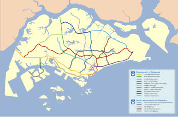
- Telok Blangah Road: Harbour Front — Kampong Bahru Road
- Kampong Bahru Road: Telok Blangah Road — Lower Delta Road
- Lower Delta Road: Kampong Bahru Road — Ganges Avenue
- Delta Road: Ganges Avenue — Zion Road
- Hoot Kiam Road/Irwell Bank Road: River Valley Road — Paterson Hill
- Paterson Hill/Paterson Road/Scotts Road: Grange Road — Stevens Road
- Stevens Road: Scotts Road — PIE
 Pan Island Expressway: Stevens Road — BKE
 Bukit Timah Expressway: PIE — Woodlands
- Johor–Singapore Causeway
Malaysia

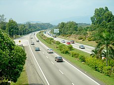
South section of North–South Expressway, facing towards Kuala Lumpur, near Ayer Keroh, Malacca
 NSE: Bukit Kayu Hitam — Alor Setar — Sungai Petani — Butterworth (Penang) — Taiping — Ipoh — Tapah — Tanjung Malim — Rawang — Bukit Lanjan
 NKVE: Bukit Lanjan — Kota Damansara — Damansara — Subang — Shah Alam
 ELITE: Shah Alam — USJ — Putra Heights — Bandar Saujana Putra — Kuala Lumpur International Airport (KLIA) — Nilai (North)
 NSE: Nilai (North) — Seremban — Ayer Keroh (Malacca) — Muar — Batu Pahat — Kulai — Johor Bahru (Pandan)
 EDL : Pandan — Bakar Batu — Johor Bahru (CIQ checkpoint)
Thailand

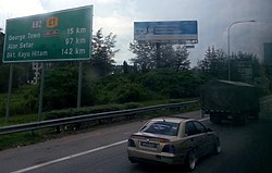
Asian Highway 2 sign near Ratchaburi, Thailand
 Route 4: Sa Dao — Hat Yai — Phatthalung, Chumphon — Pran Buri, Cha-am — Nakhon Chai Si (Concurrent with
  AH123 from Ban Pong — Nakhon Chai Si)
 Route 41: Phatthalung — Chumphon
 Route 37: Pran Buri — Cha-am (Hua Hin Bypass)
 Route 338: Nakhon Chai Si — Bangkok Outer Ring Road (Concurrent with
  AH123)
 Route 9: Bangkok Outer Ring Road — Bang Pa-in
 Route 32: Bang Pa-in — Ayutthaya (Bang Pahan) — Chai Nat (Concurrent with
  AH1) (Merges again at Bang Pahan)
 Route 347 :Bang Pa In — Bang Pahan
 Route 1: Chai Nat — Nakhon Sawan — Tak — Chiang Rai — Mae Sai (Concurrent with
  AH1 from Chai Nat — Tak)
Myanmar
- National Highway 4: Tachilek — Kengtung — Meiktila
- Yangon–Mandalay Expressway: Meiktila — Mandalay
- National Highway 7 (Concurrent with
 AH1): Mandalay — Tamu
India (Northeast)
 NH 102: Moreh — Imphal
 NH 2: Imphal — Kohima
 NH 29: Kohima — Dimapur — Nagaon — Doboka — Jorabat
 NH 27: Doboka — Jorabat
 NH 6: Jorabat — Shillong
 NH 206: Shillong — Dawki
Bangladesh
 N2: Tamabil — Sylhet — Kanchpur — Dhaka
 N3: Dhaka — Joydebpur[1][2]
 N4: Joydebpur — Tangail — Elenga
- Elenga — Hatikumrul
 N5: Hatikumrul — Bogra — Rangpur — Banglabandha
India (East)
Nepal
 Mahendra Highway: Mechi Bridge — Kakarbhitta — Pathlaiya — Hetauda — Narayangarh — Butwal — Kohalpur — Mahendranagar — Mahakali River
India (North)
- Mahakali River — Banbasa — Khatima
 NH 9: Khatima — Sitarganj — Rudrapur — Rampur — Muradabad — Amroha (Gajraula) — Hapur — Delhi
 NH 44: Delhi — Sonipat- Kurukshetra — Ambala — Jalandhar
 NH 3: Jalandhar — Ludhiana — Phagwara — Amritsar — Attari
Pakistan
- Wagah — Lahore
 Lahore — Okara — Multan — Bahawalpur — Rahim Yar Khan — Rohri
 Rohri — Sukkar — Jacobabad — Sibi — Quetta
 Quetta — Dalbandin — Taftan
Iran
 :Mirjaveh — Zahedan — Kerman — Anar
 :Anar — Kashan — Qom
 :Qom — Salafchegan
 :Salafchegan — Saveh
 :Saveh — Hamadan
 :Hamadan — Kermanshah — Khosravi (
 Arab Mashreq International Road Network)
References
- ↑ "Regional Road Connectivity Regional Road Connectivity Bangladesh Perspective" (PDF). RHD. Archived from the original (PDF) on February 19, 2017. Retrieved February 19, 2017.
- ↑ "Asian Highway Route Map" (PDF). ESCAP. Retrieved February 19, 2017.


