.svg)
Assam: Difference between revisions
Kannadaguy (talk | contribs) m (1 revision imported) |
No edit summary |
||
| Line 9: | Line 9: | ||
|motto = | |motto = | ||
<!-- images and maps -----------> | <!-- images and maps -----------> | ||
|image_skyline = | |image_skyline = Gargaon'r Kareng Ghor.JPG | ||
|imagesize = | |imagesize = | ||
|image_caption = | |image_caption = The Garhgaon Palace | ||
|image_flag = | |image_flag = Indian state flag of Assam (proposed).png | ||
|flag_size = | |flag_size = | ||
|flag_link = | |flag_link = | ||
| Line 129: | Line 129: | ||
}} | }} | ||
'''Assam''' ({{lang-as|অসম}}) is a [[States of India|state]] in the [[North-east India|north eastern region]] of [[India]]. It has an area of 78,438 [[km²]] (30,285 [[square mile|mi²]]). It is bigger than [[Panama]] but smaller than the [[Czech Republic]]. There is one major river ([[Brahmaputra River|Brahamputra]]) that flows through the length of the state. The state lies on the foothills of the [[Himalayas]]. There are two international borders touched by Assam: [[Bhutan]] and [[Bangladesh]]. In traditional Indian geography it falls under the [[North-east India]]n zone. | '''Assam''' ({{lang-as|অসম}}) is a [[States of India|state]] in the [[North-east India|north eastern region]] of [[India]]. It has an area of 78,438 [[km²]] (30,285 [[square mile|mi²]]). It is bigger than [[Panama]] but smaller than the [[Czech Republic]]. There is one major river ([[Brahmaputra River|Brahamputra]]) that flows through the length of the state. The state lies on the foothills of the [[Himalayas]]. There are two international borders touched by Assam: [[Bhutan]] and [[Bangladesh]]. In traditional Indian geography it falls under the [[North-east India]]n zone. It also borders the Chinese contested disputed occupied territory of which it refers to as [[South Tibet]], as per Sino claimed; India militarily controls it as [[Arunachal Pradesh]] to the north. | ||
== Demography == | == Demography == | ||
| Line 194: | Line 194: | ||
|value5 = 18.98 | |value5 = 18.98 | ||
|color5 = purple}} | |color5 = purple}} | ||
==Provincial symbols of Assam== | |||
<gallery> | |||
File:Indian state flag of Assam (proposed).png|Proposed Government banner, provincial flag of Assam | |||
File:White-winged Wood Duck (Cairina scutulata) RWD5.jpg|White-winged wood duck, provincial bird of Assam | |||
File:KAZIRANGA.JPG|Indian rhinoceros, provincial animal of Assam | |||
File:Dipterocarpus tonkinensis Cho nau.JPG|Hollong tree, provincial tree of Assam | |||
File:A and B Larsen orchids - Rhynchostylis retusa 1015-24.jpg|Foxtail orchid, provincial flower of Assam | |||
</gallery> | |||
==References== | ==References== | ||
Revision as of 05:23, 17 October 2021
Assam
অসম | |
|---|---|
State of India | |
 The Garhgaon Palace | |
Flag of Assam Flag  Seal | |
.svg) A map showing us where the location of Assam is in the Republic of India | |
 Map of Assam | |
| Country | |
| Region | North-east India |
| Government | |
| • Legislature | Unicameral (* seats) |
| Area | |
| • Total | 78,438 km2 (30,285 sq mi) |
| Population (2011) | |
| • Total | 31,169,272 |
| Time zone | UTC+05:30 (IST) |
| Official languages | Assamese · English |
| ^* | |
Assam (Assamese: অসম) is a state in the north eastern region of India. It has an area of 78,438 km² (30,285 mi²). It is bigger than Panama but smaller than the Czech Republic. There is one major river (Brahamputra) that flows through the length of the state. The state lies on the foothills of the Himalayas. There are two international borders touched by Assam: Bhutan and Bangladesh. In traditional Indian geography it falls under the North-east Indian zone. It also borders the Chinese contested disputed occupied territory of which it refers to as South Tibet, as per Sino claimed; India militarily controls it as Arunachal Pradesh to the north.
Demography
According to a 2021 survey,[2][3] about 55% of the people are Hindus. About 40% are Muslim.[4] There is a small (4%) Christian minority. Others (1%) consists of (Buddhism, Sikhism, Jainism, and Animism).
| Religion | Population | Percentage |
|---|---|---|
| Hindus |
20,075,000 | 55% |
| Muslims |
14,600,000 | 40% |
| Christians |
1,460,000 | 4% |
| Other's | 365,000 | 1% |
Assam has a population of 36.5 million as per 2021 population survey.[6]
Language
Provincial symbols of Assam
- Indian state flag of Assam (proposed).png
Proposed Government banner, provincial flag of Assam
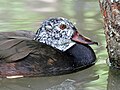
White-winged wood duck, provincial bird of Assam

Indian rhinoceros, provincial animal of Assam

Hollong tree, provincial tree of Assam

Foxtail orchid, provincial flower of Assam
_RWD5.jpg)


.png)
References
- ↑ https://www.indiatoday.in/india-today-insight/story/can-bjp-survive-the-demographic-disadvantage-in-assam-1784851-2021-03-29
- ↑ "Population by religion community – 2011". Census of India, 2012. The Registrar General & Census Commissioner, India. Archived from the original on 25 August 2015.
- ↑ "Census 2011 data rekindles 'demographic invasion' fear in Assam".
- ↑ https://www.indiatoday.in/india-today-insight/story/can-bjp-survive-the-demographic-disadvantage-in-assam-1784851-2021-03-29
- ↑ https://www.indiatoday.in/india-today-insight/story/can-bjp-survive-the-demographic-disadvantage-in-assam-1784851-2021-03-29
- ↑ Assam Population Sex Ratio in Assam Literacy rate data 2011-2021
- ↑ https://theprint.in/opinion/assam-situation-nrc-report-ripe-ethnic-violence/28399/
Related pages
| States | Andhra Pradesh • Arunachal Pradesh • Assam • Bihar • Chhattisgarh • Goa • Gujarat • Haryana • Himachal Pradesh • Jharkhand • Karnataka • Kerala • Madhya Pradesh • Maharashtra • Manipur • Meghalaya • Mizoram • Nagaland • Odisha • Punjab • Rajasthan • Sikkim • Tamil Nadu • Telangana • Uttar Pradesh • Uttarakhand • West Bengal | |
|---|---|---|
| Union Territories | ||