.svg)
Gurudwara Shri Hemkund Sahib
Gurudwara Hemkund Sahib
Gurudwara Shri Hemkund Sahib | |
|---|---|
pilgrimage site; Gurudwara | |
 Gurudwara Hemkund Sahib | |
 Gurudwara Hemkund Sahib Location in Uttarakhand, India  Gurudwara Hemkund Sahib Gurudwara Hemkund Sahib (India) | |
| Coordinates: 30°42′0.78″N 79°36′57.54″E / 30.7002167°N 79.6159833°ECoordinates: 30°42′0.78″N 79°36′57.54″E / 30.7002167°N 79.6159833°E | |
| Country | |
| State | Uttarakhand |
| District | Chamoli district |
| Elevation | 4,632.96 m (15,200.00 ft) |
| Languages | |
| • Official | Hindi[1] |
| • Regional | Garhwali[2] |
| Time zone | UTC+5:30 (IST) |
| PIN | 249401 |
| Vehicle registration | UK 11 |
| Website | www |
Hemkund Sahib (also spelled Hemkunt), formally known as Gurudwara Shri Hemkund Sahib Ji, is a Sikh place of worship and pilgrimage site in Chamoli district, Uttarakhand, India. It is devoted to Guru Gobind Singh (1666–1708), the tenth Sikh Guru, and finds mention in Dasam Granth, a work presumed dictated by Guruji himself, but insufficiently verified, where mythological components exist in the work. With its setting of a glacial lake surrounded by seven mountain peaks, each adorned by a Nishan Sahib on its cliff, it is according to the Survey of India located in the Himalayas at an elevation of 4,160 meters (13,650 feet).[3] It is approached from Govindghat on the Rishikesh-Badrinath highway. The main town near Gobindghat is Joshimath. The altitude of the lake at Hemkund is approximately 13,650 feet (4,160 m).
Etymology[edit]
Hemkund is a Sanskrit name derived from Hem ("Snow") and Kund ("bowl").

Travel[edit]

Hemkund is inaccessible from October through April because of snowbound paths and glaciers. Sikh pilgrims arrive in May and set to work to repair the damage to the path over the winter, which tradition is called kar seva ("selfless service"), a concept which forms an important tenet of the Sikh faith.
The take-off point for Hemkund Sahib is the town of Govindghat, about 275 kilometres (171 mi) from Rishikesh. The 9 kilometres (5.6 mi) trek is along a reasonably well-maintained path to the village of Ghangaria (also called Govinddham). This path can be covered either by walk or by pony and a Gurudwara here gives shelter to pilgrims. In addition, there are a few hotels and a campground with tents and mattresses. A 1,100-metre (3,600 ft)climb on a 6-kilometre (3.7 mi) of stone paved path leads to Hemkund. Overnight stay is not allowed at Hemkund Sahib, so it is necessary to leave by 2 PM to make it back to Govindghat by dusk.
From Delhi, tourists take the train to Haridwar and then travel by bus to Govindghat via Rishikesh. It is also possible to drive from Delhi to Govindghat, a distance of about 500 kilometres (310 mi) which takes around 18 hours to cover. Recently, an Indian airline company has started a helicopter service between Govindghat and Ghangria. The flight takes about 5 minutes.

A recent study examining altitude sickness at Hemkund Sahib found that almost one-third of pilgrims who traveled to Hemkund suffered from Acute Mountain Sickness (a form of altitude sickness). As approximately 150,000 pilgrims are believed to travel to Hemkund Sahib each trekking season, almost 50,000 people are at risk of developing Acute Mountain Sickness each year. The authors stated the difficult nature of the trek, limited water consumption, and lack of awareness regarding altitude sickness as the main contributory factors.[4]
Present Gurudwara[edit]
Design and construction of the present gurudwara at Hemkund was started in the mid-1960s, after Major General Harkirat Singh, KCIO, Engineer-in-Chief, Indian Army visited the gurudwara. The engineering brain behind the gurudwara project, Major General Harkirat Singh selected Architect Manmohan Singh Siali of the Military Engineering Services (MES) to head the design and construction effort. Thereafter, Architect Siali made annual trips to Hemkund Sahib and organized and supervised complex construction. M/s Sahib Singh, Harbhajan Singh & Gursharan Singh were the dedicated Gursikh contractors who worked on the construction, overcoming numerous weather, altitude, terrain, and logistic challenges. The unique design and construction are acclaimed as marvels, both of which have borne the test of sustainability over the past many decades. [5]
Valley of Flowers[edit]
About 3 kilometres (1.9 mi) from Gobinddham is the 5-kilometre (3.1 mi) long Valley of Flowers. The Indian Government has declared this valley a national park. It is situated in Nanda Devi Bio Reserve, and all activities are carefully regulated to preserve the valley. The best months to visit are July and August, during the monsoons. According to legend, a flower known as Brahma-Kamal blossoms. The trek to the valley is for advanced trekkers, especially during an extended period of rainfall. Almost every single rock on the path to the valley of flowers requires a significant level of concentration, so as to avoid potential injuries. It is a popular second destination for pilgrims visiting Hemkunt Sahib.
Gallery[edit]
- Views of Hemkund (Hemkunt) Sahib
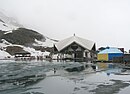
Gurudwara in front of lake

Gurdwara Hemkunt Sahib

Hibiscus flower


References[edit]
- ↑ "52nd REPORT OF THE COMMISSIONER FOR LINGUISTIC MINORITIES IN INDIA" (PDF). nclm.nic.in. Ministry of Minority Affairs. Archived from the original (PDF) on 25 May 2017. Retrieved 9 October 2019.
- ↑ "Garhwali". Ethnologue. Retrieved 24 February 2021.
- ↑ Hemkunt Sahib at Google maps Satellite view: lake, Gurudwara building on west shore, zigzag pilgrim path from Ghanghariya (2 km west) to west shore. Terrain view: Hemkund Sahib at 4,160 m, Ghanghariua at 3,100 m.
- ↑ Sahota, Inderjeets; Panwar, Nidhis (2013). "A pilot study on the prevalence of acute mountain sickness at the sikh pilgrimage of hemkund sahib in the Indian Himalayas". Indian Journal of Occupational and Environmental Medicine. 17 (1): 12–15. doi:10.4103/0019-5278.116366. PMC 3777282. PMID 24082642.
- ↑ Gurudwara Sri Hemkunt Sahib: The Design and Architecture. shrihemkuntsahib.com
Further reading[edit]
- Gurdwara in the Himalayas: Sri Hemkunt Sahib, by Suparna Rajguru, M. S. Siali. Published by Hemkunt, 2001. ISBN 81-7010-292-8.
- Pilgrimage to Hemkunt, by Jaswant Singh Neki. Photographs by Sondeep Shankar. New Delhi, UBSPD, 2002, ISBN 81-7476-375-9.