.svg)
File:Plan of River Systems of India.png
Size of this preview: 220 × 113 pixels. Other resolutions: 320 × 165 pixels | 500 × 257 pixels | 931 × 479 pixels.
Original file (931 × 479 pixels, file size: 27 KB, MIME type: image/png)
Summary
| Description |
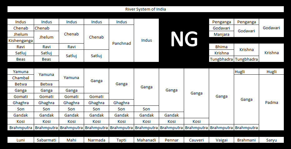
English: This image shows the tributaries and distributaries of major rivers of India on paper plan in tabular format. The Merging of cells to the right side each time indicates getting supply from a tributary and vice-versa.
The bottom-most row shows other rivers with no major helping rivers (Saryu is an exception). Flow of the rivers is assumed to be from left to right. |
| Date | |
| Source |
Studied the maps and other data, created excel format, made image |
| Author | Nitin.i.azam |
Other information
English: There are 4 river systems shown with merging and unmerging cells. Flow of a river is assumed to be from left to right. The last (bottom) row is a collection of other major rivers not associated with any river system. However, Saryu is an exception here. The symbol 'NG' in the middle is watermark of the creator, i.e. me.

Licensing
I, the copyright holder of this work, hereby publish it under the following licenses:

|
Permission is granted to copy, distribute and/or modify this document under the terms of the GNU Free Documentation License, Version 1.2 or any later version published by the Free Software Foundation; with no Invariant Sections, no Front-Cover Texts, and no Back-Cover Texts. A copy of the license is included in the section entitled GNU Free Documentation License. |
This file is licensed under the Creative Commons Attribution-Share Alike 3.0 Unported license.
- You are free:
- to share – to copy, distribute and transmit the work
- to remix – to adapt the work
- Under the following conditions:
- attribution – You must give appropriate credit, provide a link to the license, and indicate if changes were made. You may do so in any reasonable manner, but not in any way that suggests the licensor endorses you or your use.
- share alike – If you remix, transform, or build upon the material, you must distribute your contributions under the same or compatible license as the original.
You may select the license of your choice.

|
The categories of this image need checking. You can do so here.
|
File history
Click on a date/time to view the file as it appeared at that time.
| Date/Time | Thumbnail | Dimensions | User | Comment | |
|---|---|---|---|---|---|
| current | 14:43, 23 November 2012 | | 931 × 479 (27 KB) | wikimediacommons>Nitin.i.azam | {{subst:Upload marker added by en.wp UW}} {{Information |Description = {{en|This image shows the tributaries and distributaries of major rivers of India on paper plan in tabular format. The Merging of cells to the right side each time indicates getting... |
File usage
The following page uses this file: