.svg)
File:NE Autonomous divisions of India.svg

Size of this PNG preview of this SVG file: 220 × 153 pixels. Other resolutions: 320 × 223 pixels | 500 × 349 pixels | 489 × 341 pixels.
Original file (SVG file, nominally 489 × 341 pixels, file size: 539 KB)
Summary
| Description |
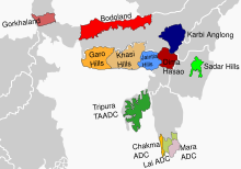
English: Map of North East India's autonomous divisions.
Self made, with use of the following existing images:
Missing information on the following divisions due to lack of information about boundaries: Assam:
Manipur:
|
| Date | |
| Source | Own work |
| Author | RaviC |
Licensing
I, the copyright holder of this work, hereby publish it under the following license:
This file is licensed under the Creative Commons Attribution-Share Alike 4.0 International license.
- You are free:
- to share – to copy, distribute and transmit the work
- to remix – to adapt the work
- Under the following conditions:
- attribution – You must give appropriate credit, provide a link to the license, and indicate if changes were made. You may do so in any reasonable manner, but not in any way that suggests the licensor endorses you or your use.
- share alike – If you remix, transform, or build upon the material, you must distribute your contributions under the same or compatible license as the original.
File history
Click on a date/time to view the file as it appeared at that time.
| Date/Time | Thumbnail | Dimensions | User | Comment | |
|---|---|---|---|---|---|
| current | 03:35, 20 May 2022 | | 489 × 341 (539 KB) | wikimediacommons>আফতাবুজ্জামান |
File usage
The following 15 pages use this file:
- Administrative divisions of India
- Autonomous administrative divisions of India
- Chakma Autonomous District Council
- Garo Hills Autonomous District Council
- Gorkhaland Territorial Administration
- Jaintia Hills Autonomous District Council
- Khasi Hills Autonomous District Council
- Lai Autonomous District Council
- Mara Autonomous District Council
- Meghalaya
- Northeast India
- Northeast India border disputes
- Proposed states and union territories of India
- Sadar Hills
- Tripura