Chakma Autonomous District Council
Chakma Autonomous District Council | |
|---|---|
| Coat of arms or logo | |
| Type | |
| Type | Autonomous District Council |
| Leadership | |
Chairperson | Mohan Chakma (MNF) |
Chief Executive Member | Durjya Dhan Chakma (MNF) |
| Structure | |
| Seats | 24 Councillors |
Political groups | Government (12)
Opposition (8) |
| Elections | |
| 20 plurality voting | |
| 4 nominated | |
Last election | 2018 |
| Meeting place | |
| Kamalanagar | |
| Website | |
| https://www.cadc.gov.in/ | |
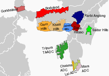
The Chakma Autonomous District Council is an autonomous council for the Chakma people living in the south-western part of Mizoram, India. It covers the Tuichawng(Chawngte) subdivision of Lawngtlai district. Its headquarters is at Kamalanagar. The Chakma people has been demanding to change the status of the Chakma Autonomous District Council into a Union territory under the name Chakmaland.[1][2][3]
The Chakma Autonomous District Council was formed under the Sixth schedule of the Constitution of India on 29 April 1972. The Council is the replication of the state assembly and exercises executive power over specially allotted departments. It is one of the three Autonomous District Councils of Mizoram state in North-East India. It is an autonomous council for ethnic Chakma people living in South-Western Mizoram bordering Bangladesh and Myanmar. There is also a growing demand for 'Chakmaland' union territory.
History[edit]
In 1954 the Central and Assam governments established a regional council, the Pawi Lakher Regional Council (PLRC), for the Lakhers (aka Mara) and the Pawis (aka Lai), in which a large number of [Chakmas people|Chakmas ]] also resided. However, the PLRC could not function properly right from its inception as there was no common communication language among the three tribal communities to understand each other. The first meeting was held without understanding each other’s language where Mizo was used as official language but Chakmas and Maras could hardly understand anything. Consequently, in 1958 the Maras boycotted PLRC meetings. In 1972, to resolve the issue the PLRC was divided into three regional councils and upgraded to 3 district councils for Maras, Lais and Chakmas.[4]
Geography[edit]
The surface area of the Chakma Autonomous District Council is 686.25 sq.km[5].The headquarters of Chakma Autonomous District Council is Kamalanagar, which means the orange land in Chakma language. It is also known as Chawngte-C. It is parted into Kamalanagar -1,2,3 & 4. There is only one college in CADC called as Kamalanagar College located at Kamalanagar-2 (Randokpur). Kamalanagar is located on the north-eastern corner of C.A.D.C and on the bank of Tuichawng river. On the east of Kamalanagar town i.e. on the other bank of Toizong (Tuichawng) there stands two Mizo villages known as Chawngte P and Chawngte L. On the eastern bank of Toizong is divided by the rivulet, Chawngte L (Ponsury as called by the Chakmas) the northern bank falling under Lunglei General district and the southern bank Chawngte P, under Lai autonomous District Council.
Economy[edit]
Majority of the Chakmas in Mizoram take up farming as their occupation. This occupation is inherited from their ancestors. They mainly grow rice, vegetables and fruits, etc. Rice is considered as the staple food of the Chakmas living in Chakma Autonomous District Council.
Demographics[edit]
The total Chakma population of Mizoram is estimated to be more than 100,000 (as per the 2011 census - 96,972). The population of Chakma Autonomous District Council are primarily Chakmas who are a designated Schedule Tribe. The total population of CADC is 45,307 as per 2011 census out of which 70% of it is dependent on agriculture. The population grew from 34,528 in 2001[4] to 40,265 (as of 2008). The majority of the people of Chakma Autonomous District Council follow Theravada Buddhism.[6]
Religion of Chakma Autonomous District Council in 2011 census
Structure[edit]
Chakma Autonomous District Council has a total of 24 Members of District Council (MDC), out of which 20 MDCs are elected and 4 MDCs are nominated. The council is led by a Chief Executive Member (CEM) and Executive Members (EMs). The present CEM is Durjya Dhan Chakma. He is appointed on 2021.
Departments[edit]
It has a total of 27 No. of departments and they are as follows:
- Legislative Department
- Judicial Department
- Finance Department
- General Administration Department
- Agriculture Department
- Horticulture Department
- Fishery Department
- Public Health Engineering Department
- Industry Department
- Sericulture Department
- AH & Vety Department
- Art & Culture Department
- Social Welfare Department
- Soil & Water Conservation Department
- Local Administrative Department
- Environment & Forest Department
- Road Transport Department
- Sport & Youth Department
- Co-operative Department
- Public Works Department
- Education Department
- Rural Development Department
- Water ways Department
- Information & Public Relation Department
- District School Education Board
- Land Revenue & Settlement
- Planning & Development Department
Number of village councils[edit]
CADC have 73 villages.
- Adhubangasora
- Ajasora - I
- Ajasora - II
- Ajasora - III
- Baganpara
- Borunasury
- Bajeisora
- Bandukbanga
- Betbonia
- Bilosora
- Boraguisury
- Borakabakhali
- Borapansury - I
- Borapansury - II
- Borkolok
- Boroituli
- Bottuli
- Charluitlang
- Chhotaguisury - I
- Chhotaguisury - II
- Chhotapansury
- Devasora 'N'
- Devasora 'S'
- Dursora
- Fulsora
- Fultuli
- Futsury
- Geraguluksora
- Gerasury
- Gobasury
- Golasury
- Gulsingbapsora
- Jamersury
- Jaruldobasora
- Jarulsury
- Kamalanagar - I
- Kamalanagar - II
- Kamalanagar - III
- Kamalanagar - IV
- Kamtuli
- Kukurduleya
- Kurbalavasora
- Lokhisury
- Longpuighat
- Ludisora
- Mandirasora
- Maniabapsora - I
- Maniabapsora - II
- Montola
- Nadarasora
- Nalbania
- New Chhippui
- New Jagnasury - I
- New Jagnasury - II
- Old Bajeisora
- Parva - I
- Parva - II
- Parva - III
- Rajmandal
- Rengashya
- Silosora
- Silsury
- Simeisury
- Siminesora
- Udalthanasora - I
- Udalthanasora - II
- Ugalsury
- Ugudasory 'S'
- UgudasurY 'N'
- Ulusury
- Vaseitlang - I
- Vaseitlang - II
- W.Saizawh
Politics[edit]
Of the 20 elected District Council Members- MNF (18), BJP (2).[7]
Of the 516 village council seats in Chakma Autonomous District Council, the Mizo National Front has 371 seats, Bharatiya Janata Party has 115 seats, Indian National Congress has 2 seats and independent candidates have 27 seats. The MNF is in majority in 65 village Councils while the BJP is in majority in 16 village Council.In the remaining 4 Village Council no party has absolute majority.[8]
See also[edit]
- Buddha Dhan Chakma
- Lai Autonomous District Council
- Mara Autonomous District Council
- North Eastern Council
- Hill tribes of Northeast India
References[edit]
- ↑ "The Chakmas In Mizoram Are Struggling To Secure Their Rights And Identity". Retrieved 2 March 2021.
- ↑ Taba Ajum (21 September 2017). "SC verdict on Chakmas, Hajongs could prove catastrophic for Arunachal". Arunachal Times. Retrieved 2 March 2021.
- ↑ "Nhrc issues notice to states over allegations of denial of benefits under pmgkay and impds". Retrieved 11 September 2021.
- ↑ 4.0 4.1 "Chakma Autonomous District Council" Agriculture Department, Mizoram State Annual Plan 2003-2004 Archived 21 July 2011 at the Wayback Machine page 284, last accessed 23 December 2010
- ↑ https://www.cadc.gov.in/
- ↑ "Religion PCA". Census of India 2011. Office of the Registrar General.
- ↑ "Mizoram: 3 Cong Chakma council members, 6 ex-councillors join BJP". Retrieved 19 March 2019.
- ↑ "Ruling MNF sweeps Mizoram village council polls, bypoll". Retrieved 19 March 2019.

