.svg)
File:Hindi Indoarisch.png

Size of this preview: 220 × 231 pixels. Other resolutions: 229 × 240 pixels | 358 × 375 pixels | 877 × 919 pixels.
Original file (877 × 919 pixels, file size: 573 KB, MIME type: image/png)
Y
Summary
| Description |
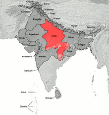
Deutsch: Verbreitungsgebiet von Hindi
English: Area where Hindi is spoken natively (Hindi in the mid-narrow sense of Eastern and Western Hindi languages) |
| Date | |
| Source |
Deutsch: Kartenvorlage: demis.nl-
Verbreitungsgebiet nachgezeichnet nach der Karte Language families and branches, languages and dialects in A Historical Atlas of South Asia, Oxford University Press. New York 1992.
English: Base map template: demis.nl.
Source for map data: Language families and branches, languages and dialects in A Historical Atlas of South Asia, Oxford University Press. New York 1992. |
| Author | based on Image:Indoarische Sprachen.png, Image:Indoarische Sprachen Verbreitung.png by BishkekRocks |
Licensing

|
Permission is granted to copy, distribute and/or modify this document under the terms of the GNU Free Documentation License, Version 1.2 or any later version published by the Free Software Foundation; with no Invariant Sections, no Front-Cover Texts, and no Back-Cover Texts. A copy of the license is included in the section entitled GNU Free Documentation License. |
| This file is licensed under the Creative Commons Attribution-Share Alike 3.0 Unported license. | ||
| ||
| This licensing tag was added to this file as part of the GFDL licensing update. |
Atlas
This map should be added to the Wikimedia Atlas.
File history
Click on a date/time to view the file as it appeared at that time.
| Date/Time | Thumbnail | Dimensions | User | Comment | |
|---|---|---|---|---|---|
| current | 13:31, 27 July 2023 | | 877 × 919 (573 KB) | wikimediacommons>PadFoot2008 | Corrected lines based on sourced linguistic classification. |
File usage
The following page uses this file: