File:Collecting LIDAR data over the Ganges and Brahmaputra River Basin.ogv
The media handler extension for this file format is missing. Advanced media features may not work unless the file is viewed at Wikimedia Commons.
Size of this preview: 220 × 124 pixels. Other resolutions: 320 × 180 pixels | 500 × 281 pixels | 1,920 × 1,080 pixels.
Original file (file size: 14.36 MB, MIME type: application/ogg)
Summary
| Description |
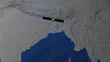
English: Animation of a generic satellite collecting digital elevation map data over the Ganges and Brahmaputra River basin. |
| Date | |
| Source | Goddard Multimedia |
| Author | NASA/Goddard Space Flight Center |
Licensing
| This file is in the public domain in the United States because it was solely created by NASA. NASA copyright policy states that "NASA material is not protected by copyright unless noted". (See Template:PD-USGov, NASA copyright policy page or JPL Image Use Policy.) | ||
 |
Warnings:
|
File history
Click on a date/time to view the file as it appeared at that time.
| Date/Time | Thumbnail | Dimensions | User | Comment | |
|---|---|---|---|---|---|
| current | 03:15, 21 March 2013 |  | (14.36 MB) | wikimediacommons>Originalwana | {{Information |Description ={{en|1=Animation of a generic satellite collecting digital elevation map data over the Ganges and Brahmaputra River basin. }} |Source =[http://svs.gsfc.nasa.gov/goto?4047 Goddard Multimedia] |Author =NASA/... |
File usage
The following page uses this file: