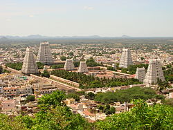
Adaiyur, Tiruvannamalai
This article needs additional citations for verification. (February 2012) |
Adaiyur
Adaiyoor | |
|---|---|
suburb | |
 Annamalaiyar temple at Thiruvannamalai | |
| Coordinates: 12°12′N 79°03′E / 12.20°N 79.05°ECoordinates: 12°12′N 79°03′E / 12.20°N 79.05°E | |
| Country | |
| State | Tamil Nadu |
| District | Tiruvannamalai |
| Taluka | Tiruvannamalai taluk |
| Government | |
| • Municipal special mayor | Balachandran (ADMK) |
| Elevation | 171 m (561 ft) |
| Population (2011) | |
| • Total | 19,560 |
| Languages | |
| • Official | Tamil |
| Time zone | UTC+5:30 (IST) |
| PIN | 606 (605,606) |
| Telephone code | 91-4175 |
| Vehicle registration | TN 25 |
| Sex ratio | 998 ♂/♀ |
| Lok Sabha constituency | Thiruvannamlai |
| Vidhan Sabha constituency | Thiruvannamalai city |
Adaiyur is a suburb of the town of Thiruvannamalai, in the Indian state of Tamil Nadu. Administratively, it is a panchayat village[1] of Tiruvannamalai taluk in Tiruvannamalai District.[2] It is located on the Kanji road about 3 km northwest of downtown Thiruvannamalai. Panchayat President: M.Kalaivani munusamy from-(2020)
Demographics
Its 2011 population was 7500, up from 9,230 in the 2001 census. (This phrasing makes no sense)
Mineral wealth
Recent research proves there is iron ore in the Adaiyoor region and hills, but native people did not agree to give the land for factories.[citation needed]
Notes
- ↑ 2011 Village Panchayat Code = 234687, "Reports of National Panchayat Directory: Village Panchayat Names of Tiruvannamalai, Tiruvannamalai, Tamil Nadu". Ministry of Panchayati Raj, Government of India. Archived from the original on 24 April 2013. Retrieved 24 April 2013.
- ↑ 2011 Census Village code = 633278, "Reports of National Panchayat Directory: List of Census Villages mapped for: Adaiyur Gram Panchayat, Tiruvannamalai, Tiruvannamalai, Tamil Nadu". Registrar General & Census Commissioner, India. Archived from the original on 24 April 2013. Retrieved 24 April 2013.
