Nallavanpalayam
This article has multiple issues. Please help improve it or discuss these issues on the talk page. (Learn how and when to remove these template messages)
|
Palayam
Nallavan Palayam palayam | |
|---|---|
Town panchayat | |
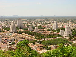
 Annamalaiyar temple at Tiruvannamalai | |
| Coordinates: 12°11′N 79°03′E / 12.18°N 79.05°ECoordinates: 12°11′N 79°03′E / 12.18°N 79.05°E | |
| Country | |
| State | Tamil Nadu |
| District | Tiruvannamalai |
| Government | |
| • President | Uma Elumalai(ADMK) |
| Area | |
| • Total | 16.3 km2 (6.3 sq mi) |
| Elevation | 171 m (561 ft) |
| Population (2012) | |
| • Total | 6,921 |
| • Density | 420/km2 (1,100/sq mi) |
| Languages | |
| • Official | Tamil |
| Time zone | UTC+5:30 (IST) |
| Telephone code | 91-4175 |
| Vehicle registration | TN 25 |
| Lok Sabha constituency | thiruvannamlai |
| Vidhan Sabha constituency | thiruvannamalai city |
| Climate | moderate (Köppen) |
| Avg. summer temperature | 41 °C (106 °F) |
| Avg. winter temperature | 18 °C (64 °F) |
Palayam is a Village in Tiruvannamalai Taluk in Tiruvannamalai District in Tamil Nadu State in India . Nallavanpalayam is 4.1 km distance from its Taluk Main Town Tiruvannamalai . Nallavanpalayam is 3.7 km distance from its District main city Tiruvannamalai and 161 km distance from its State main city Chennai.
Near By towns & Villages with distance are Melchettipattu (2.2 km), Viswanthangal (2.9 km), Melkachirapattu (3.5 km), Meyyur (3.6 km), Tiruvannamalai (3.7 km),. Near By towns are Tiruvannamalai (4.1 km), Thandrampet (11.2 km), Thurinjapuram (21.9 km), Keelpennathur (24.7 km),
Nallavanpalayam Pin Code is 606603, 606 604, 606 605.
demographics[edit]
Palayam having population of over 7000 providing sub urban to Tiruvannamalai urbanity. it comes under Tiruvannamalai urban agglomerations on Salem (via - harur & thandarampattu) road SH -9. there is one railway station for Palayam as "NALLAVAN PALAYAM" shortly as"N.P"at up coming route of tiruvannamalai-thandaramapttu-chengam-singarapet-uthangarai-samalpatti-bargur-vepannahalli-bangalore (k.r.puram) railway route.
