Nine Degree Channel
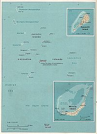
The Nine Degree Channel is a channel in the Indian Ocean between the Laccadive Islands of Kalpeni and Suheli Par, and Maliku Atoll (Minicoy Island).[1] These two subgroups of islands, together with the Amindivi Subgroup, form the Indian Union Territory (UT) of Lakshadweep.[2]
The Channel is approximately 200 km wide with a depth of 2597 metres. The Investigator Bank is located in the southern region of the channel.
It is so named as it lies on the 9-degree line of Latitude, north of the equator.
Sea Lane of Strategic Importance
The 200 kilometres of the Nine Degree Channel separating Kalpeni and Suheli Par from Minicoy sees the passage of nearly all merchant shipping between Europe, the Middle-East and Western Asia with South-East Asia and the Far-East.
Gallery of nearby important channels
Cocos Strait, Duncan Passage and other Indian channels
South China Sea, Malacca Strait, Gulf of Thailand, Sulu Sea, Celebes Sea
See also
- Geostrategic context
References
- ↑ Prostar Sailing Directions 2005 India & Bay of Bengal Enroute, National Geospatial-intelligence Agency
- ↑ An Act to alter the name of the Union territory of the Laccadive, Minicoy and Amindivi Islands
External links
Coordinates: 9°N 73°E / 9°N 73°E
