Sunda Strait
| Sunda Strait | |
|---|---|
 H.C.S. Sir David Scott at the entrance to Sunda Strait, February 1830 | |
| Lua error in Module:Location_map at line 526: Unable to find the specified location map definition: "Module:Location map/data/Indonesia" does not exist. | |
 | |
| Coordinates | 5°55′S 105°53′E / 5.92°S 105.88°ECoordinates: 5°55′S 105°53′E / 5.92°S 105.88°E |
| Type | Strait |
| Native name | (language?) |
| Etymology | Sunda Kingdom |
| Part of | Java Sea |
| Basin countries | Indonesia |
| Min. width | 24 km (15 mi) |
| Average depth | −20 m (−66 ft) |
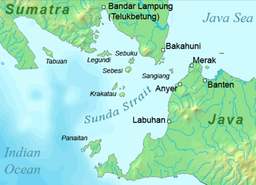
The Sunda Strait (, Hindi: सुन्दा जलडमरूमध्य or सुन्दा जलग्रीवा) is the waterway that lies between the Indonesian islands of Java and Sumatra, serving as a connection between the Java Sea and the Indian Ocean.
Etymology[edit]
The strait derives its name from the historical Sunda Kingdom, which governed the western part of Java, encompassing present-day West Java, Jakarta, Banten, and parts of western Central Java, from 669 until around 1579. Additionally, the name references the Sundanese people indigenous to West Java and Banten.
Geography[edit]
The strait runs in a roughly southwest-northeast direction, with its narrowest point measuring 24 km at the northeastern end, located between Cape Tua on Sumatra and Cape Pujat on Java. It features a triangular shape, flanked by two large bays on its northern side. While it is quite broad and deep at the southwestern end, the northeastern section becomes significantly shallower, with depths dropping to as little as 20 m in some areas.
Navigating the strait can be particularly challenging due to its shallow waters, strong tidal currents, sandbanks, and artificial structures like oil platforms along the Java coast. Historically, the Sunda Strait was a vital shipping route, particularly during the era of the Dutch East India Company, which utilized it as a gateway to Indonesia's Spice Islands from 1602 to 1799. However, its narrowness and shallowness, coupled with the lack of precise navigational charts, render it unsuitable for many contemporary large vessels, which typically favor the Strait of Malacca instead.
The strait is home to several islands, most of which are volcanic in nature, including Sangiang (Thwart-the-Way), Sebesi, Sebuku, and Panaitan (Prince's). The catastrophic eruption of Krakatau in 1883 had significant short- and long-term effects on the region, resulting in devastating tsunamis and pyroclastic flows that claimed tens of thousands of lives. Of the 3,000 inhabitants on the nearby island of Sebesi at the time, none survived. Some areas were never resettled and are now part of Ujung Kulon National Park.
See also[edit]
- Geostrategic context
- Andaman and Nicobar Command
- Andaman Sea
- Bay of Bengal
- Exclusive economic zone of Indonesia
- Exclusive economic zone of India
- Local context